Heat and fire weather continue to dominate the west
Aug 09, 2025

We managed to have a couple of days this week where flash flooding was not a major threat, but that is over now as the summer of flash flooding gets active again this weekend. The cold front that has been moving across the northern Rockies and Plains causing severe weather in the region as well as enhancing fire danger across parts of the West will be plodding across the upper Midwest this weekend and focusing thunderstorms with heavy rainfall.
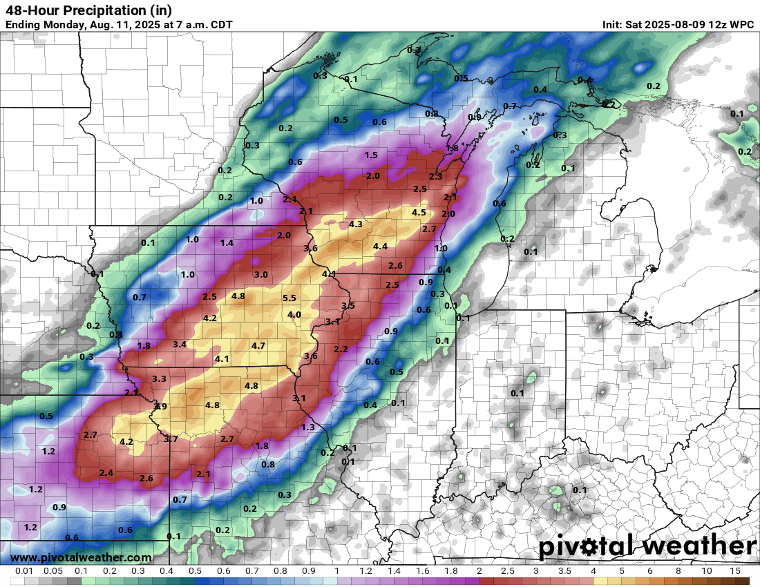
Multiple rounds of thunderstorms producing intense rainfall rates are expected across the region, with widespread rainfall amounts of 4 to 7 inches expected in a broad swath from northeast Kansas to southern Wisconsin.
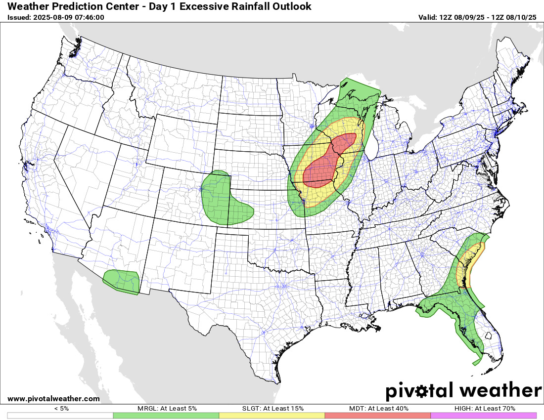
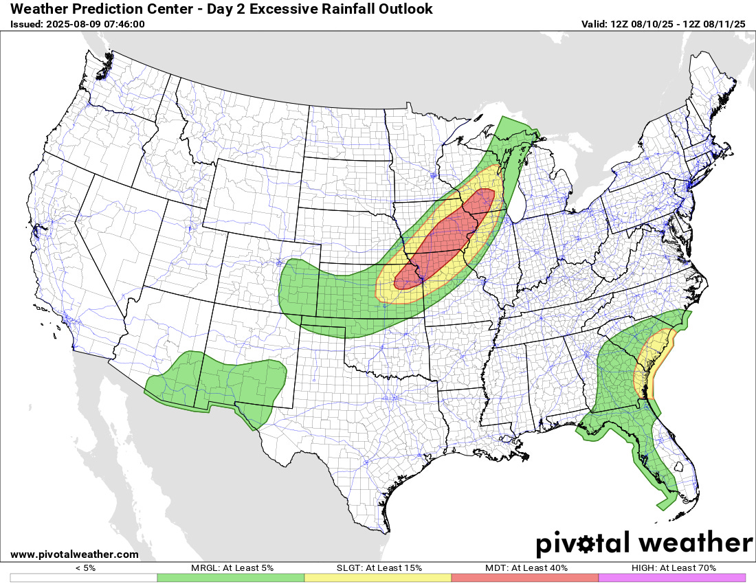
Moderate (level 3 of 4) risks of flash flooding have been issued by the Weather Prediction Center (WPC) for both today and Sunday. Areas across eastern Iowa and northeast Missouri would seem to be particularly vulnerable to flash flooding from an antecedent conditions perspective, as much of that area has been wet over the last two weeks with up to 200% of normal rainfall.

Given the recent rainfall and already high river levels, significant river flooding is also possible in this region.
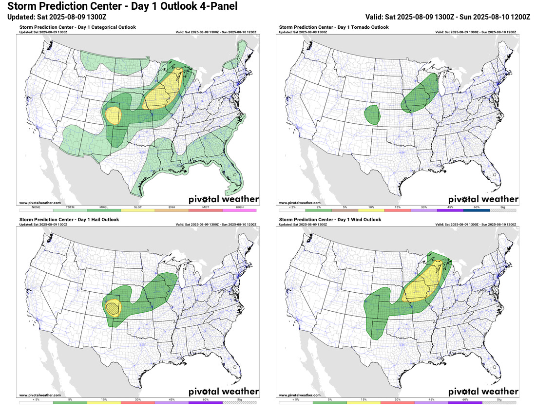
Severe thunderstorms are also possible in this region today, with damaging downburst winds the primary severe weather risk. A slight (level 2 of 5) risk of severe storms is also in place in eastern Colorado, where supercell storms could produce very large hail and possibly a couple of tornadoes.
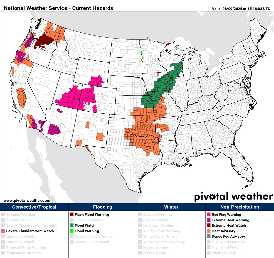
Heat stress continues to be a significant concern across the central and western United States, with heat advisories and extreme heat warnings in effect for a number of locations as shown above. Elevated fire weather conditions also continue across large parts of the West, and particularly in the Intermountain West and central Rockies region where red flag warnings are in effect and a number of large wildfires are already burning.
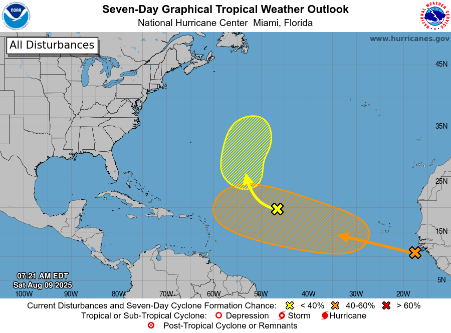
In the tropics, the tropical disturbance in the central Atlantic — 96L — continues to struggle with dry air and is unlikely to develop over the next few days. As we discussed yesterday, there is a bit of a window for development early next week as the system is moving north well east of Bermuda, but NHC has lowered the probabilities to 20%. The tropical wave that is southeast of the Cabo Verde Islands in the eastern Atlantic looks as if it will be in a more favorable environment for development over the next week as it moves west-northwest, and NHC now has it outlooked with a medium (40%) chance of developing into a tropical cyclone.
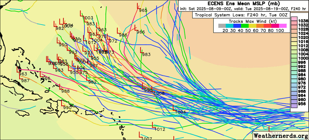
The models are quite bullish on this system; as an example, most of the 50 members of the overnight European ensemble model shown above develop the system into a tropical storm or hurricane by the time it reaches the western Atlantic in about a week to 10 days. Whether the system moves more to the west or recurves more to the north depends on a number of factors: how quickly the system develops, its speed of movement, and when and how strong of a weakness in the subtropical ridge across the western Atlantic develops about a week from now. Bottom line, there is a lot of time to watch this system, but it is one to have an eye on as we head into next week.

The area of disturbed weather we have been discussing from the southeast Gulf across the Bahamas will continue to move slowly west and northwest over the weekend. While a few model solutions continue to show a weak system developing out of this, it appears like this will remain mainly a enhancement to rain and thunderstorms across Florida this weekend and the Gulf Coast early next week.

In the Pacific, Tropical Storm Ivo has pulled away from the coast of Mexico and is expected to weaken over the next couple of days. Meanwhile, Henriette weakened to a depression, but is forecast to reintensify into at least a strong tropical storm as it moves on a rather unusual track well to the north of Hawaii over the next several days.

Leave a comment