New state of climate report raises lots of red flags; Invest 98L in Gulf showing signs of increased organization
Aug 14, 2025
The American Meteorological Society today released its annual State of the Climate report for 2024. AMS has been publishing an annual summary climate assessment each year since 1996. It provides a detailed update on climate indicators and other developments related to the global climate. With contributions from scientists around the globe and a rigorous peer review process, this has always been an important report, but it will likely become even more relied upon in the United States going forward given recent Trump Administration attacks on the federal National Climate Assessments.

I encourage you to at least read the highlights of the report in this media release here. The first paragraph of the release is a pretty sobering summary of the overall document:
According to the 35th annual State of the Climate report, greenhouse gas concentrations, the global temperature across land and oceans, global sea level, and ocean heat content all reached record highs in 2024, and glaciers lost the most ice of any year on record.
I have mentioned before that I was much more skeptical about global climate change early in my career; one of the main things that really spurred my evolution in thought about the topic was the massive retreat of glaciers that we have seen globally.
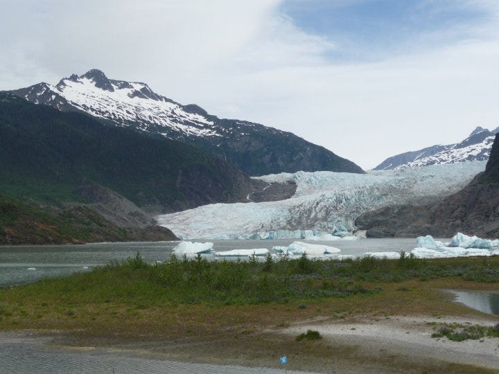
With the glacier outburst flooding on the Mendenhall River near Juneau in the last couple of days, there has been increased focus on Mendenhall Glacier, probably the most well known and visited glacier in the United States. The picture above is a picture my wife took on a family trip to Alaska in 2010.
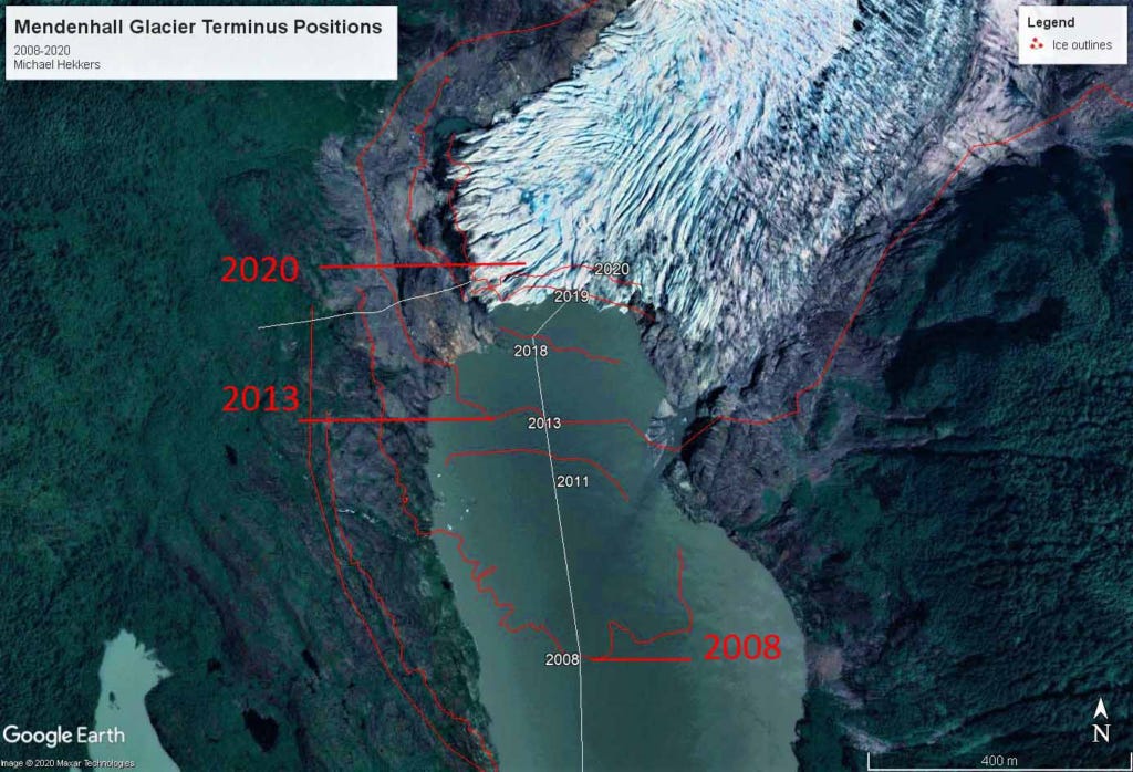
The glacier has been retreating since it reached a maximum in the mid 1700s at the end of the Little Ice Age, but that retreat has been accelerating due to the human-caused climate change. By the time we visited in 2010, it had retreated well away from the visitor’s center, and as the map shows above, it has continued to retreat up the Mendenhall Valley since then. It is now approximately 1.5 miles from the Visitor’s Center which was near the base of the glacier when it was built in 1962.
Glacial retreat is one of the most clear signs of the increasing warmth of the planet, and has a very tangible impact on society. Glaciers are a source of freshwater in many parts of the world, and their loss puts further stress on an already shrinking water budget available for human use and consumption. Melting glaciers and ice sheets are also the biggest source of sea level rise.
Another point from the AMS report I want to highlight is about the water cycle and global water vapor:
The water cycle continued to intensify. Higher global temperatures impacted the water cycle. Water evaporation from land in the Northern Hemisphere reached one of the highest annual values on record. The global atmosphere contained the largest amount of water vapor on record, with over one-fifth of the globe recording their highest values in 2024. This far exceeded 2023, where only one-tenth of the globe experienced record-high values of total column water vapor. Precipitation was globally high; 2024 was the third-wettest year since records began in 1983. Extreme rainfall, as characterized by the annual maximum daily rainfall over land, was the wettest on record. In April, Dubai in the United Arab Emirates recorded 9.8 in (250 mm) of rain in 24 hours — nearly three times its annual average.
These findings about the water cycle and increased moisture in the atmosphere are particularly meaningful as we continue to live through this 2025 summer of humidity and flash flooding. The April 2024 event in Dubai is an extreme example of the type of events we have been seeing frequently in the United States this summer with intense rainfall rates causing serious flash flooding, especially in vulnerable urban areas. As long as this trend with the water cycle continues, rainfall rates are only going to increase, and unless we rapidly upgrade infrastructure and warning systems to account for this trend, flash flooding impacts will only grow more costly and deadly.
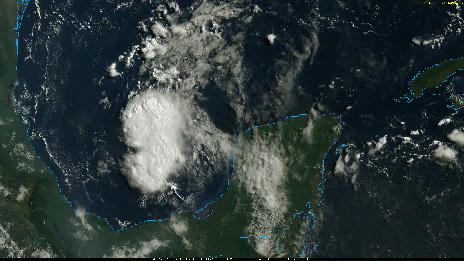
Starting off our daily weather tour in the tropics, but not with Erin, but rather a much closer to home system, the recently designated disturbance 98L in the south central Gulf. I mentioned this system a couple of days ago when it was down off the coast of Honduras. It looked like it was trying to organize then, but it has been tracking northwest over land much of the time since. It recently emerged into the Gulf off the Yucatan, and ever since it has been looking like it is trying to get better organized. There certainly seem to be indications in the visible satellite imagery that a low level circulation is trying to form within the northern part of the thunderstorm complex being produced by the disturbance.
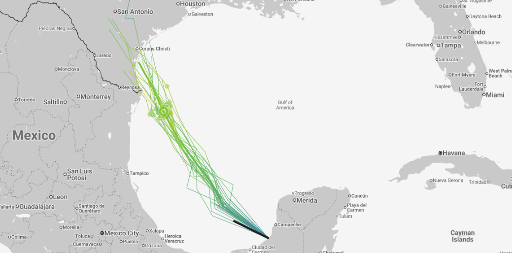
Overall atmospheric conditions look fairly supportive for development, and the models now seem to be trending toward at least a tropical depression potentially developing from 98L. The Google DeepMind AI system is shown above, and it shows the system developing into a low end tropical storm as it moves toward south Texas.
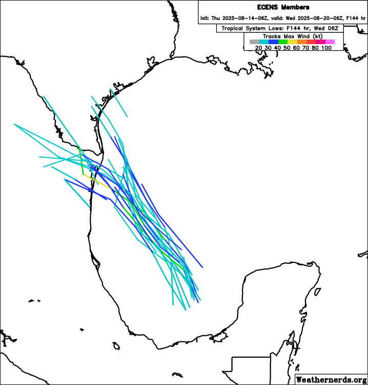
Meanwhile, the most of the members of the most recent European ensemble make 98L at least a tropical depression, with several developing into a tropical storm. Right now NHC has a low (20%) probability of tropical cyclone formation, and at a minimum I would expect that will be increased as we go through the day.
Luckily, this system only has about another 24 or so hours over water so its time to organize or intensify is short. US Air Force Reconnaissance out of Keesler AFB, MS is scheduled to investigate the system later today, so we should have a much better idea of what is going on with 98L by this evening. Regardless of development, it looks likely to bring increased increased rainfall and thunderstorms to south Texas.

Turning now to Erin, it has definitely become better organized in the last 24 hours. It still looks to be under a bit of easterly wind shear with most of the thunderstorm activity west of the center, but the thunderstorm activity is more robust and organized than yesterday. NHC now estimates the maximum sustained winds with Erin at 60 mph, a strong tropical storm.
Over the next few days Erin will be moving into an environment characterized by increasing moisture and sea surface temperatures providing an increasingly favorable thermodynamic environment for development. However, wind shear may increase a bit again, so as of now it seems like no more than steady intensification can be expected, with Erin likely to become a hurricane in the next 24 hours. It actually looks like the most favorable period for intensification may be in the 3 to 5 day period, when wind shear is forecast to be weakest and sea surface temperatures the warmest.
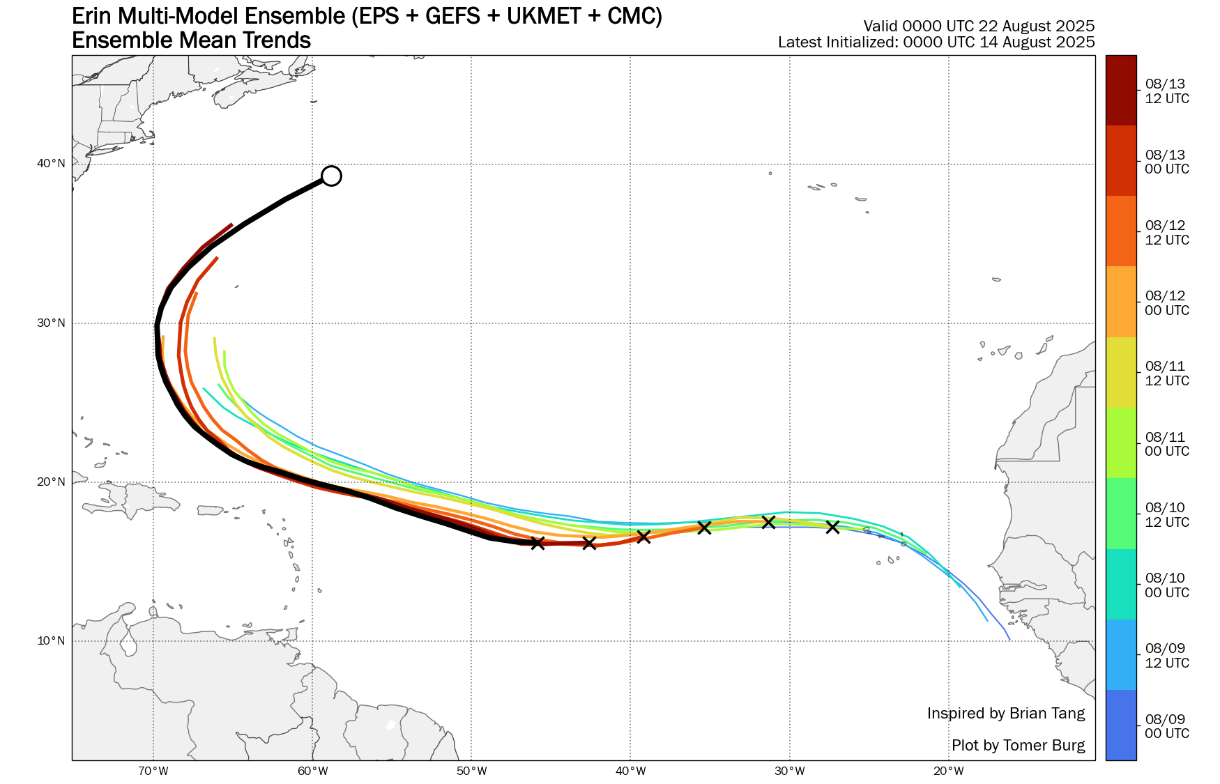
As far as track, the increased organization of the system in the last 24 hours means Erin will probably start to move a bit more poleward with time, meaning it should not get too close to the northeastern Caribbean Islands. Still, some impacts from squalls and bands of thunderstorms extending southward from the center can be expected. Farther out, as this trend in the model consensus — all of the global models essentially averaged together — shows, the model forecasts have shifted a bit more to the west over the last couple of days (most recent forecast in black). However, nearly all of the various deterministic and ensemble model solutions continue to show Erin recurving well east of the United States with Bermuda continuing to be the primary location of any concern. We are still several days out though, and there are some potential complicating factors that could arise in the long term track of Erin, so for now the East Coast should keep an eye on the forecast and trends.

Elsewhere around the country, plenty of moisture will be in place over the southern and eastern United States with scattered to numerous showers and storms expected. Locally heavy rains are possible in many areas, but a more focused risk for flash flooding is outlooked by the Weather Prediction Center from the Tidewater into southern South Carolina. Severe storms are possible in the upper Midwest today as an upper level disturbance and cold front move through the region. Monsoonal moisture will bring some high based thunderstorm activity to the Southwest and Intermountain West.

The thunderstorm activity in the Intermountain West has a particular concern for having limited rainfall and possible lightning induced fire activity. Red flag warnings are in effect for much of this area today. With all of the humidity and widespread above normal temperatures, heat stress will be relatively high over much of the eastern United States, and heat advisories are in effect for several areas in the Midwest and South.

Leave a comment