Goes from cat 1 to cat 5 in less than 24 hours
Aug 16, 2025
This post’s headline seems to be a pretty common theme in recent years: hurricane does something rarely seen before. To quickly summarize what Erin has performed in the last 24 hours: on the 5 pm ET advisory from NHC yesterday Erin had maximum sustained winds of 75 mph (minimal category 1 hurricane) and a minimum central pressure — the lowest pressure in the center of the storm, and a key indicator of intensity — of 993 millibars (mb, 29.32” of mercury). On the 2 pm ET intermediate advisory from NHC this afternoon, Erin had maximum sustained winds of 160 mph (category 5) with a minimum central pressure of 915 mb (27.02”). So in 21 hours, it intensified 85 mph and deepened (lower pressure) 78 mb. Rapid intensification, indeed – this is in the absolute upper echelon of strengthening episodes ever observed in the Atlantic.
Taking away the rapidity of the intensification and just looking at how strong it is, my colleague Michael Lowry pointed out that Erin is only the 5th category 5 hurricane this early in the season, and the first that did not form in the Caribbean or Gulf.
I mentioned in my early week post that if Erin intensified as much as forecast this early, it could be a sign that overall conditions in the Atlantic are particularly favorable this year. To build on that point, all of the years that my colleague Steve Bowen noted that had 150+ mph hurricanes by this point were quite active seasons.
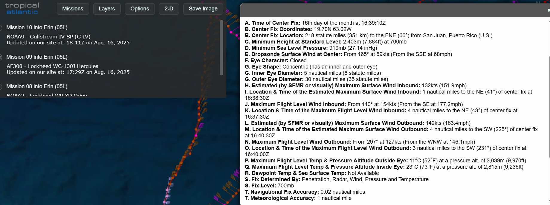
Looking at what the short and longer term future of Erin looks to be, I want to start by building a bit on my hurricane primer post and talk about the last fix (decoded Vortex Data Message above) by the US Air Force reconnaissance flight that just completed its mission in Erin, and demonstrate what incredibly important information we get from these scientists and pilots willing to fly into these storms.
Starting with the basics, line B is the precise center fix of the hurricane from the plane. Line D in the minimum central pressure measured by a dropsonde released by the plane: 919 mb. The next line, E, tells what the dropsonde observed as far as wind when it hit the water: 165 degrees at 59 knots. Now, the goal of the crew is to drop the dropsonde in the exact center and get a calm wind when it splashes. That has to be an incredibly difficult job given how rapidly the plane is flying through the storm, and I am amazed at how often they manage to hit it. Erin, though, has an extremely small eye: 5 nmi. As my meteorologist colleague Brian Tang amusingly pointed out this morning:
There is a general rule of thumb that for each 10 knots of wind observed on dropsonde splash, deduct 1 mb of pressure when estimating the central pressure of the hurricane. 59 knots is one of the largest winds I’ve seen on a splash – and NHC made a best guess on the advisory of 915 mb .
Lines F and G tell the character of the eye as observed by the crew: in this case closed (no breaks or openings in the eye) and concentric, meaning there are two eyewalls, one 5 nmi in diameter and the other 30 nmi in diameter. The presence of concentric eyewalls is hugely important information for meteorologists as it tells us that an eyewall replacement cycle (ERC) is in progress. An ERC is a natural process that intense hurricanes go through in which a new outer eyewall forms, chokes off the inner eyewall, and the outer eyewall becomes the main eyewall. This process results in a leveling off or perhaps some weakening, so Erin is likely near a peak in intensity. However, this process also results in the hurricane becoming larger in size.
Right now, Erin is a very small hurricane; lines H through O tell where the maximum winds were observed on the inbound and outbound legs into the eye. Flight level is the wind the plane observed, surface wind is the wind observed by the plane’s Step Frequency Microwave Radiometer (SFMR), a tool that estimates the surface wind through observing the character of the ocean water below using a microwave instrument. The maximum inbound and outbound winds were observed at 1 nmi and 4 nmi respectively, incredibly close to the eye and indicative of small, tight intense hurricane. The ERC will likely result in Erin becoming a slightly less intense, but larger, hurricane.
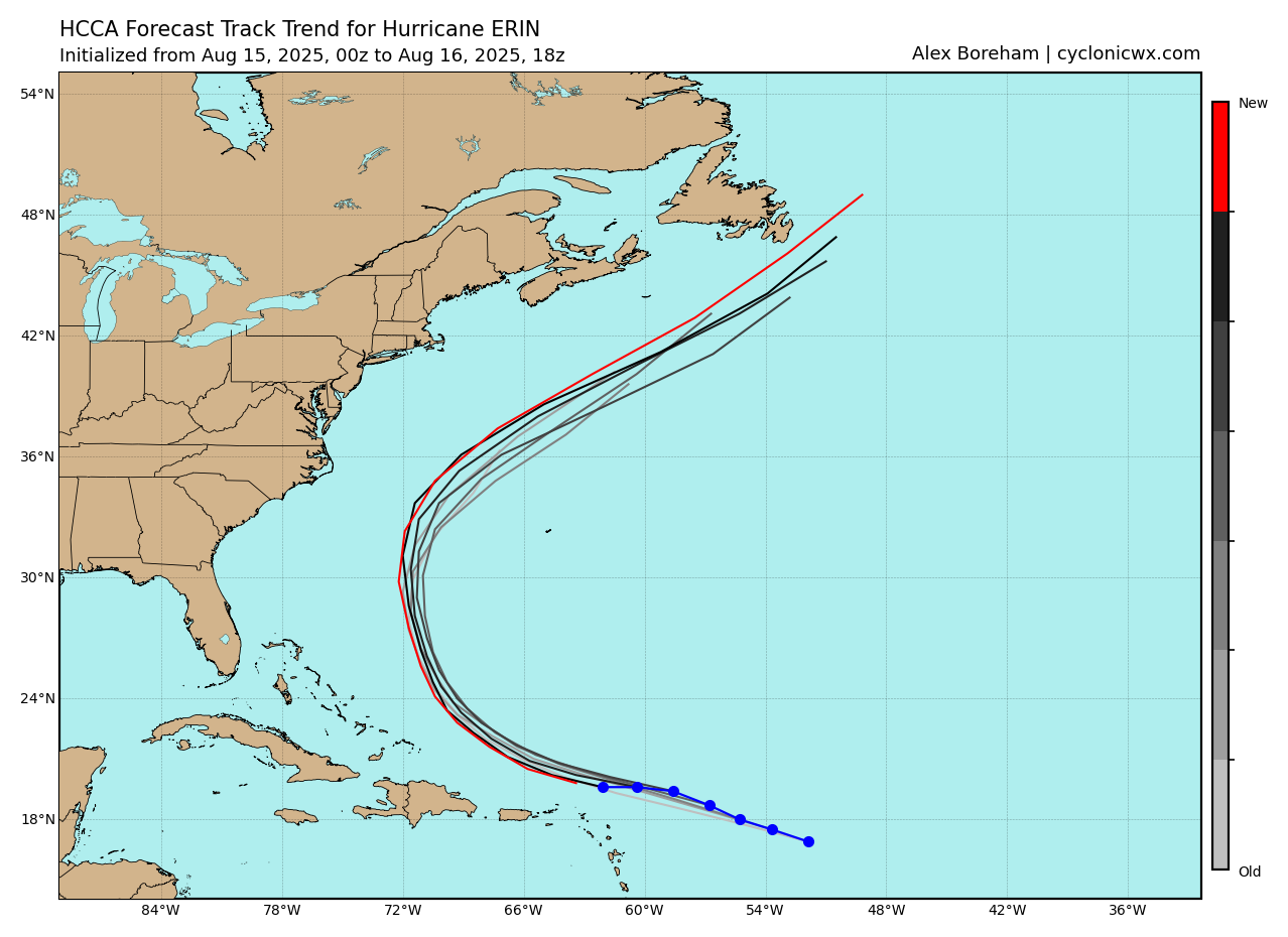
As far as the track, there has been a fair amount of strang and durm on social media today about the fact that Erin has been moving pretty much due west and a bit south of forecasts. That motion is likely mainly due to the strengthening process and trochoidal wobbling that is common very intense hurricanes like Erin. Having said that, as can be seen in the HCCA consensus track guidance that there has been a bit of a shift to the left in the guidance in the last 24 hours, and there are certainly some members of the model spread (e.g., the morning operational European model and some of the western most members of the European ensemble) that show a far enough west track to possibly bring some impacts to the eastern Bahamas and even the Outer Banks. Bottom line, while the main impacts to the East Coast still look to be high surf and rip currents, folks in the Bahamas, Bermuda and the East Coast (especially the Outer Banks region) need to be following Erin closely.
I will be back on a regular schedule tomorrow – and will also share any key updates I see with Erin using Substack notes and Bluesky/Facebook posts.

Leave a comment