In weather: record heat in the West, several tropical systems to keep an eye on
Aug 31, 2025
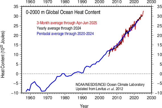
Starting off with a disturbing graphic shared this morning by the incredible climate scientist Zack Labe, who is a great follow for more climate information like this. The heat content in the upper 2000 meters of the global ocean hit another record last month, and as you can see in the chart above, the trend in recent years, and really since 1990, is alarming. Not only is climate change going to be particularly evident and trackable in the ocean given how much of the planet it covers and its integral role in our climate system as a heat sink, much of the tangible societal and ecological impacts from global warming will be seen in the ocean.
Sea level rise, melting ice, acidification, coral bleaching are just some examples of the potentially disastrous impacts on human and animal life to our oceans driven by global warming. Many of the potential climate “tipping points” — critical thresholds which if surpassed could yield irreversible and catastrophic changes to the planet’s climate — are centered around the oceans.
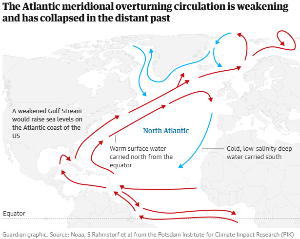
Just this week, a new study was published showing that the probability of a breakdown of the Atlantic Meridional Overturning Circulation (AMOC) — the driver of the Gulf Stream — prior to 2100 is much greater than previously estimated. This particular study found that the probability is as high as 25% even if Paris agreement carbon emissions are used in model simulations — and we are far from reaching those emission goals currently. While obviously this is just one study and other earlier studies showed lower probabilities of AMOC breakdown, AMOC breakdown would be such a calamitous event that even very low probabilities must be taken seriously, as “it would shift the tropical rainfall belt on which many millions of people rely to grow their food, plunge western Europe into extreme cold winters and summer droughts, and add 50cm to already rising sea levels.”
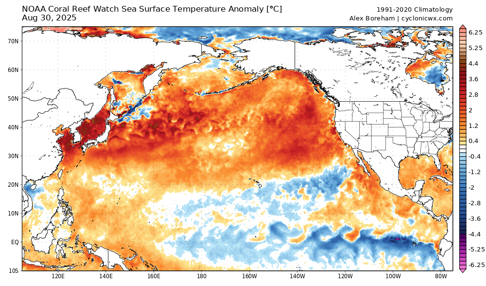
Of course, the record warm oceans are having tangible impacts on our atmosphere and society today. The increased oceanic heat means that marine heatwaves are more common, and for island nations this can lead to prolonged periods of record heat and humidity. Japan is living that reality this summer as it is surrounded by water temperatures nearly 5C above normal and has been locked in a nearly continuous record heat wave. The country broke its record for hottest temperature ever observed on two separate occasions separated by a week, the most recent being 107F at Gunma north of Tokyo on August 5. In the last month, more than 15 cities including Kyoto set new all-time hottest temperature records.
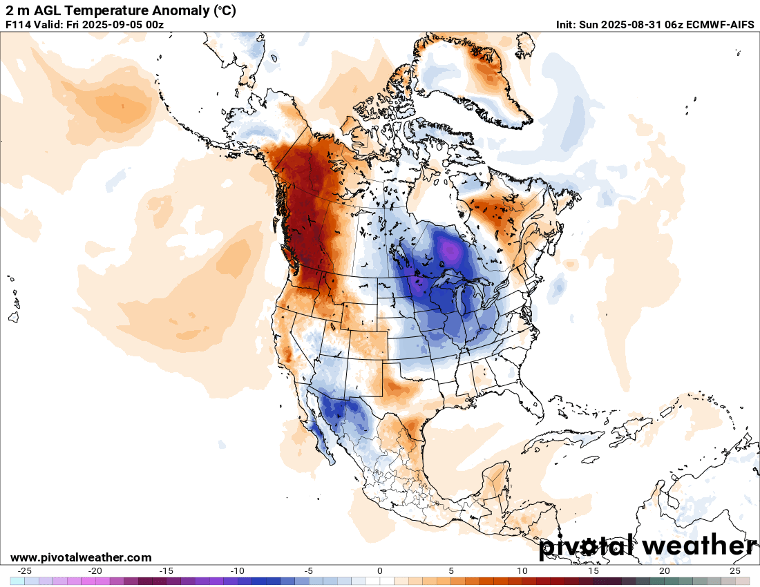
This week, western North America will be seeing record heat, with the heat wave looking to peak in the Wednesday through Friday time period. The all-time September national high temperature for Canada of 40C looks to be in danger as it seems likely that an interior station in British Columbia will reach that level at some point this week.
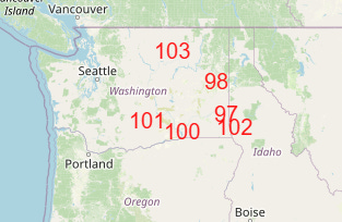
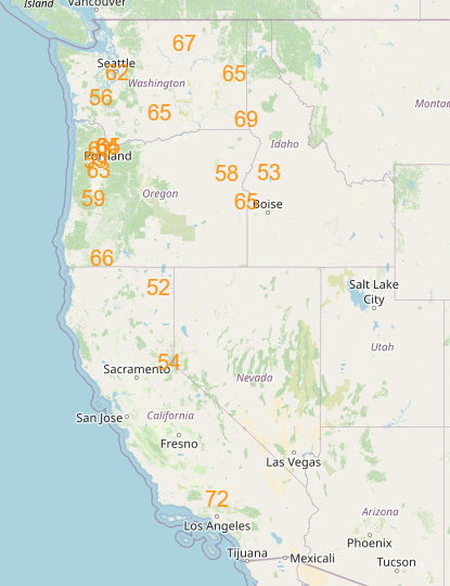
Record temperatures will be seen in the western United States as well, with a number of record highs (top) and warm minimums (bottom) expected on Wednesday. The hot and dry weather along with some potential high based, mostly dry thunderstorm activity will likely result in increased fire danger across much of western North America this week. Numerous large wildfires are already in progress in this region, with British Columbia alone reporting 58 out-of-control fires, so this is obviously a worrisome trend.
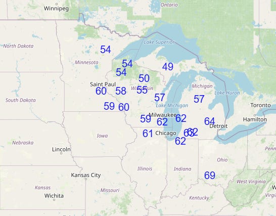
As can be seen in the surface temperature anomaly map a few graphics up, downstream of the West Coast heat, unseasonably cool air will be centered over the upper Midwest and Great Lakes. While currently this airmass does not look as if it will support widespread record low temperatures, on the peak day of the cool weather Thursday, clouds and the cold airmass will likely result in a number of record cool maximum temperatures in this region as shown above.

For today’s weather, the central part of the nation and along the Gulf and Southeast coasts will be the primary focus for thunderstorm activity. A slight (level 2 of 4) risk of excessive rainfall is in place from extreme southeast Arizona across much of central and southern Texas for localized intense rainfall that could cause flash flooding.
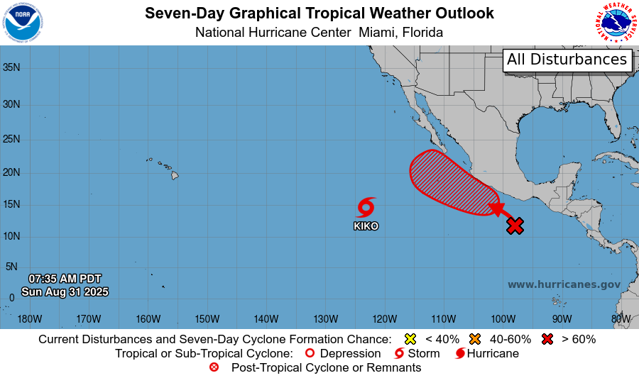
In the tropics, Invest 93E that we were talking about yesterday has become Tropical Storm Kiko in the east-central Pacific. This system is expected to slowly intensify into a hurricane as it moves west into the central Pacific ocean. The long range models suggest at least some risk for it to pass close enough to Hawaii to be of interest to the islands.
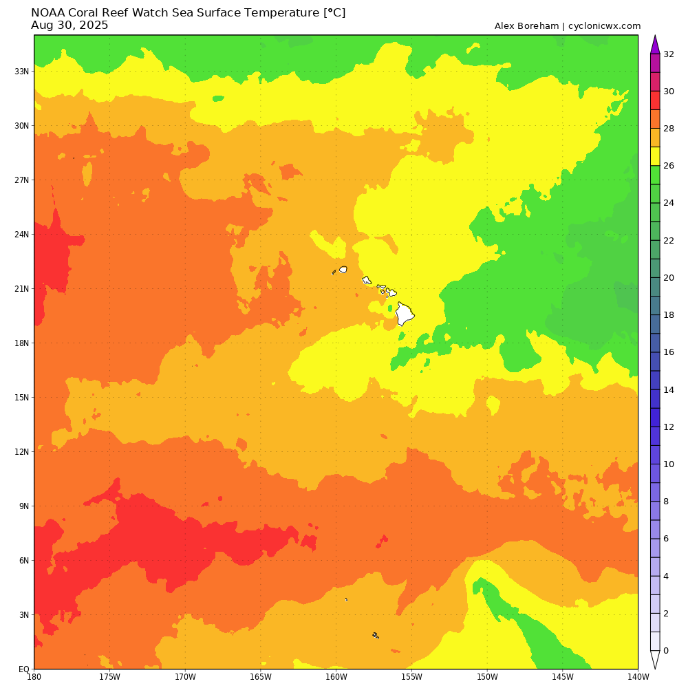
However, in contrast to what we talked about with Hurricane Henriette a few weeks ago and it taking advantage of much warmer than normal sea surface temperatures (SSTs) north of Hawaii, the SSTs south of Hawaii are actually a bit cooler than normal, so even if it moves on a track closer to the islands it will be moving over sub-26C SSTs that would likely promote weakening of any system. Regardless, we will of course watch it.
The other system in the eastern Pacific will likely become at least a tropical storm this week as it moves northwest off the coast of Mexico. In the longer range, the models have some discrepancies as the physical global models such as the European ensemble keep the system farther west, while the Google DeepMind AI shows a track farther east which could potentially bring some impacts to Baja California and some moisture to the Southwest. Another system to watch.
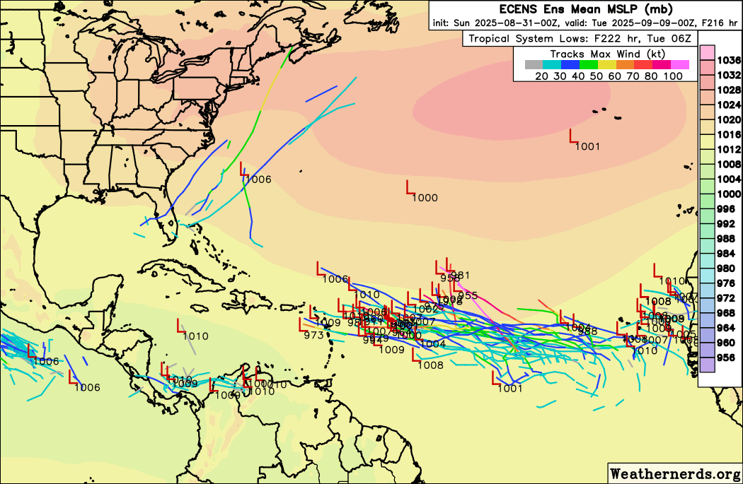
In the Atlantic, NHC continues to show a 30% probability of development on a tropical wave in the far eastern Atlantic. The models suggest a reasonably favorable environment eventually evolving ahead of it, and most of the European ensemble members show above develop at least a tropical depression or storm out of it as it moves west to west-northwest across the Atlantic over the next 7-10 days. The old stationary front from the Gulf into the Southwest Atlantic will continue to support areas of thunderstorm activity that could at some point pose some risk of development, but the situation has not really changed since yesterday and the probability overall is low.

Leave a comment