And announcing a new weather podcast project
Mar 03, 2026
Starting off today’s newsletter with a programming note that I am excited about. A couple of months ago at the International Association of Emergency Managers meeting in Louisville, I had the opportunity to go to dinner with my longtime friend John Gordon, who had recently retired as the Meteorologist-in-Charge (MIC) of the NWS there. Accompanying us was Tom Johnstone, who I knew back to my days as a forecaster in Cleveland in the early 1990s when he was at the then-new NWS office in Wilmington, OH. Tom also recently retired from NOAA as the MIC of that office.
At dinner, John outlined for us an idea he had been thinking of for a podcast. He is a fan of a podcast where a commercial airliner pilot (Captain Steeeve) uses his expertise and insider knowledge to explain newsworthy incidents and accidents in the aviation world. John thought that a similarly focused podcast after weather events would be an excellent way to educate people on not only the meteorology of events, but also the “behind the curtain” processes that get crucial forecasts and warnings to the public. Tom and I were both very interested in this idea, and agreed to work with John to further develop the concept.
Fast forward to today, and working with Tom’s friend and partner at Nashville Severe Weather Andrew Leeper, we are rolling out the new podcast “Debris Ballers.” In this pilot episode, we talk about our goals and plans for this podcast, which is for it to be a pop-up, unscheduled show after significant weather events in which we review the event and provide our analysis and insight based on our combined 100+ years as NOAA meteorologists.
While I am not familiar with the Captain Steeeve podcast, I have been listening a lot lately to “The Rest is History” and am hoping that “Debris Ballers” can have a smidge of the vibe and expertise in talking meteorology that Dominic and Tom have for discussing history on their show. For any of you familiar with John from his work over the last year with James Spann on WeatherBrains, you know that with him as the creator of this podcast, it will always be an interesting and fun listen. I hope you will join us as weather events happen in the coming months.
Learn about other BalancedWx Services
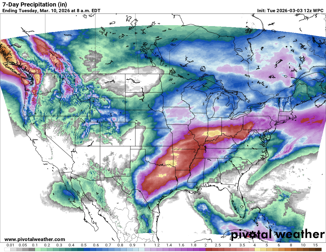
Looking at whether this week will bring us any significant weather events, we are still anticipating a wet week from east Texas northeast into the Ohio Valley as the upper level pattern dramatically shifts toward a major ridge of high pressure over the Eastern United States being the dominant feature for the next 7-10 days, with an upstream trough of low pressure to the west.
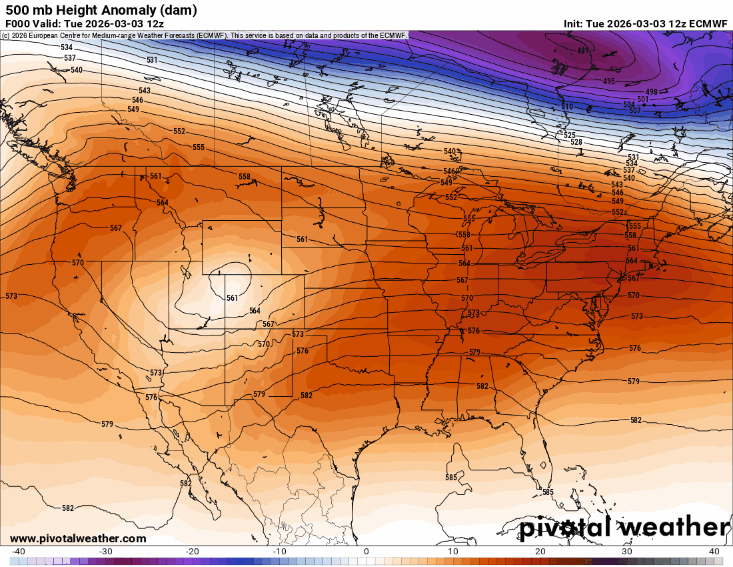
However, if we look at the forecast evolution of the mid to upper level atmospheric weather pattern as shown by this morning’s European model, we can see some very important changes in contrast to what was anticipated for this pattern several days ago. Instead of getting a persistent trough of low pressure along the latitude of the Rockies, it now looks as if the northern part of that trough will rapidly pull east and weaken as the southern portion breaks off and forms an upper level low pressure center west of Baja California this weekend. So while we are still anticipating a wetter and more active pattern for the central US this week, it now looks as if that pattern will not be quite as active or persistent as it looked last week.

Severe thunderstorms will definitely be a risk for the next several days as shown by the NCAR AI probabilistic forecasts based on the European ensemble shown above. However, given the forecast middle and upper level pattern evolution, right now it does not seem like a major severe weather outbreak or a day with a significant tornado risk looks to be in play this week.
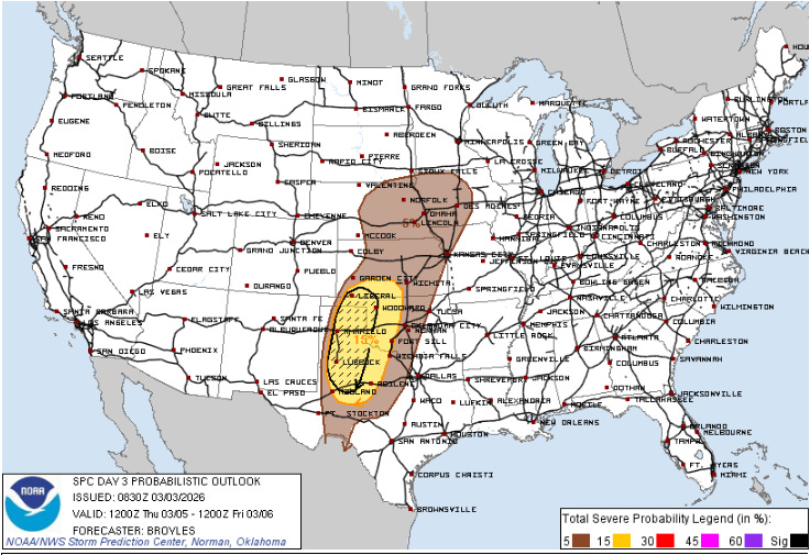
The NWS Storm Prediction Center is highlighting Thursday for some potential supercell severe storms with very large hail over the Texas and Oklahoma Panhandle regions.
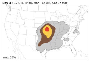
Friday looks like the most active day for severe storms as the initial low pressure system shifts east, and as shown by the SPC and AI (NCAR Euro for Friday above) forecasts. Again, though, as of now the pattern suggests more of a hail and straight line wind threat than a significant tornado concern. The period around next Tuesday will be another time to watch for severe weather as a new upper level trough will drop through the Rockies and pick up the upper low off of Baja, potentially resulting in a stronger storm system with greater severe weather potential. Obviously, that is still a week away and we have plenty of time to watch how the model forecasts evolve.
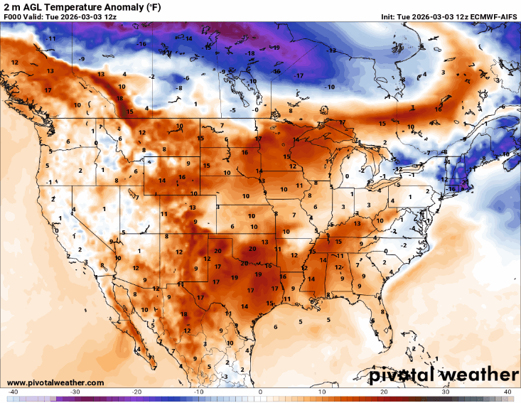
One thing that this weather pattern will definitely bring is a prolonged period of unseasonable and at times record warmth to the country east of the Rockies for the next 7-10 days as shown in this loop of surface temperature anomaly through next Wednesday from this morning’s European AI model.
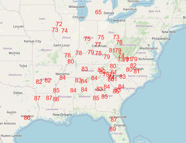
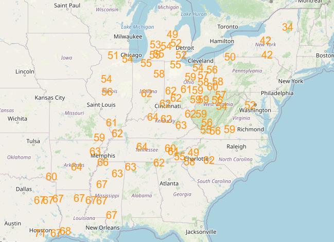
Numerous record warm maximum and minimum temperatures are expected Friday through Saturday across the eastern half of the country — with numerous records likely again in the Tuesday to Wednesday timeframe of next week. However, as you can see at the end of that temperature animation above, colder looks to start building in Canada by early next week, and as that starts to seep south and southeast, more wintry temperatures look probable by late next week into Mid-March, especially for the Upper Midwest, Great Lakes and Northeast.

Leave a comment