Longer term intensity and track forecast still rather uncertain
Oct 21, 2025
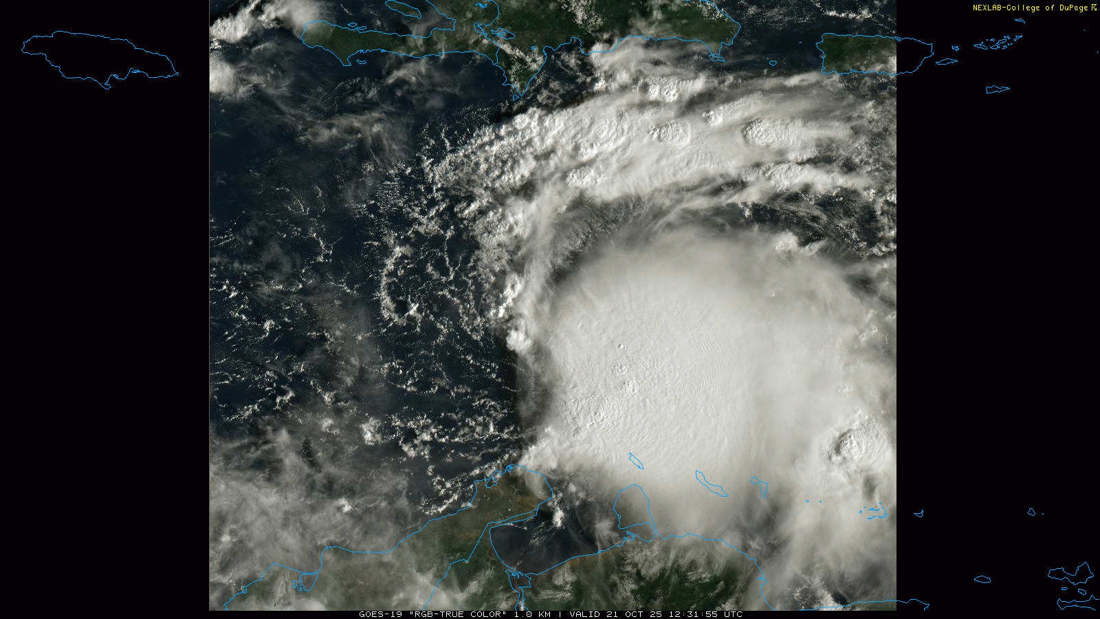
First light visible imagery this morning shows that the system we have been tracking over the Caribbean Sea continues to get better organized. A large mass of thunderstorm activity exists to the east and southeast of a developing low pressure center just a bit farther south than halfway between Hispaniola and the South American coast.
The system is already producing 45 mph winds and NHC just issued a statement that it is now Tropical Storm Melissa and they will be starting advisories and forecasts on it shortly. The fact that most of the thunderstorm activity is east and southeast of the center shows that the developing storm is still under some west-northwest upper level wind shear. While that wind shear is forecast to continue to gradually weaken, how fast that happens and how quickly Melissa intensifies will have a big bearing on the track forecast.
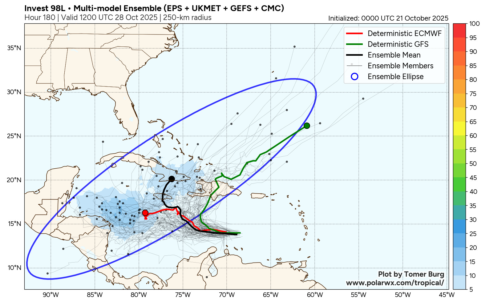
The track forecast has become slightly clearer since yesterday, but still has some significant uncertainties. There remain two camps in the models: a faster intensifying storm that turns northeast fairly quickly and moves across Hispaniola and out to sea, and a slower developing system that meanders west-northwest much of the next week. The second camp has evolved some since yesterday as most of the ensemble members in that camp now bring the system north or northeast out of the Caribbean in the next 10 days, it is more a matter of how quickly that recurve happens.
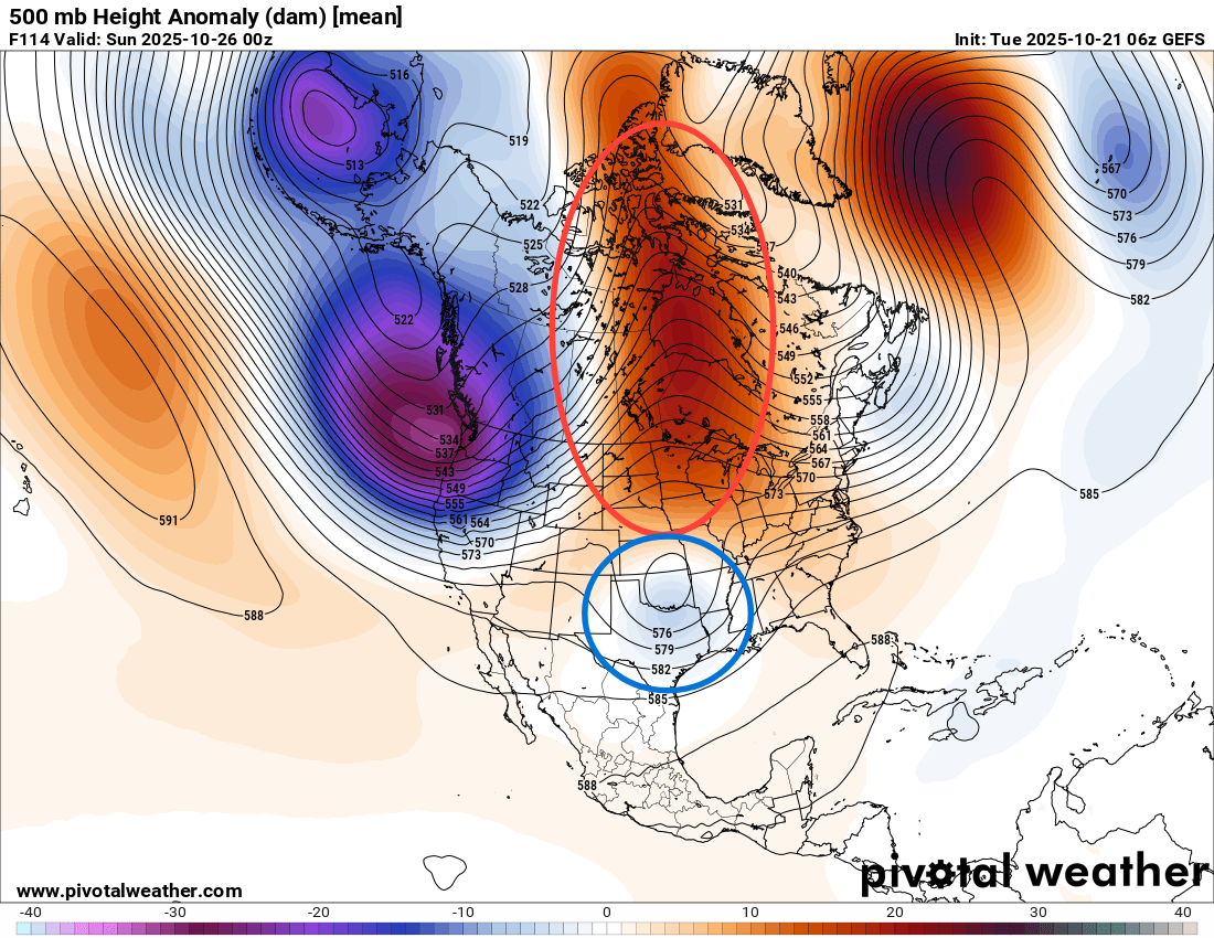
I want to take a pause here from talking about the developing tropical system to step back and talk about the overall mid and upper level wind flow pattern across North America. The pattern at 500 millibars (18K ft AGL, US Global Ensemble Forecast System 5 day forecast for Sunday evening shown above) remains highly amplified and complex. By this weekend, an unusually strong area of high pressure (red ellipse) will be over central Canada and the upper Midwest, while an upper level low pressure area will be sliding under it across the Lower Mississippi Valley. This is a notoriously challenging pattern for the models, and the models have been trending stronger with the low near the Gulf Coast — and with another system that follows behind. If Melissa is still around the western and central Caribbean when these two systems pass to its northwest, there would likely be some interactions and we could see some forecast changes.
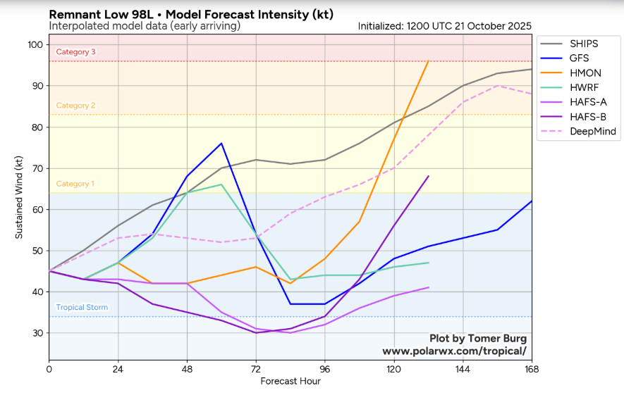
As far as intensity, the model solutions with the faster intensification and more northeast track do quickly make the system a hurricane with decreasing shear and very warm ocean waters. However, this scenario would probably have a lower ceiling for how intense the system would get as it would be interacting with Hispaniola in a few days, which would cause weakening. Meanwhile, the slower more west solutions would keep the system over very warm Caribbean waters for a much longer period, so even though the intensification the next few days would be slow, this is probably the scenario which could result in a more powerful hurricane.
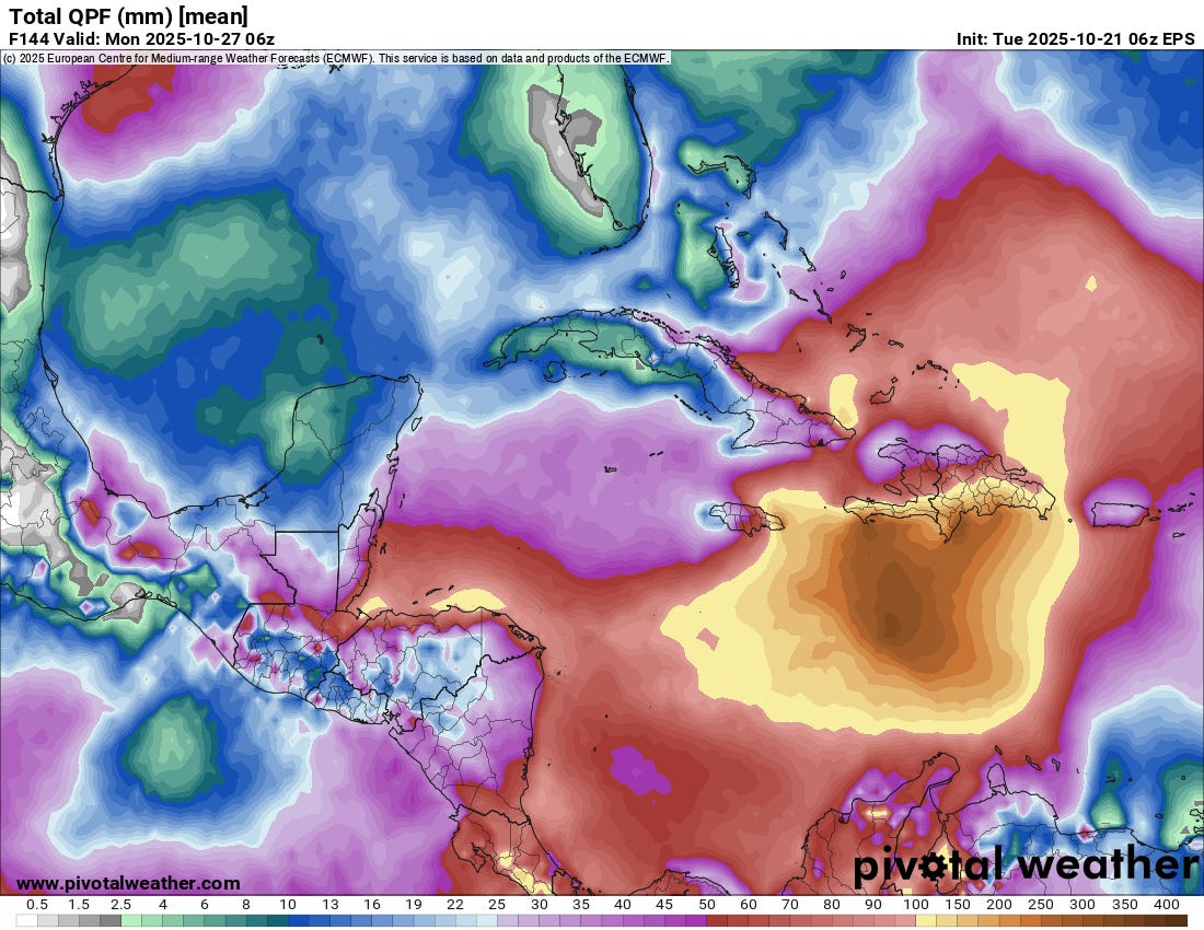
One aspect of this system that is becoming increasingly clear is the potential for very large rainfall totals and significant flooding in Hispaniola. Even the European ensemble, which has most of its members with the farther west solution, shows rainfall totals of up to a foot along the southern coastal region where extreme moisture is pushed into the mountains. Model solutions with more of a northeast turn show much heavier totals that encompass much of the island. If the forecast trends toward a slower farther west track, that would also bring parts of the Cuba into the risk of heavy rainfall (and of course potentially wind and surge issues as well wherever the system ends up tracking).
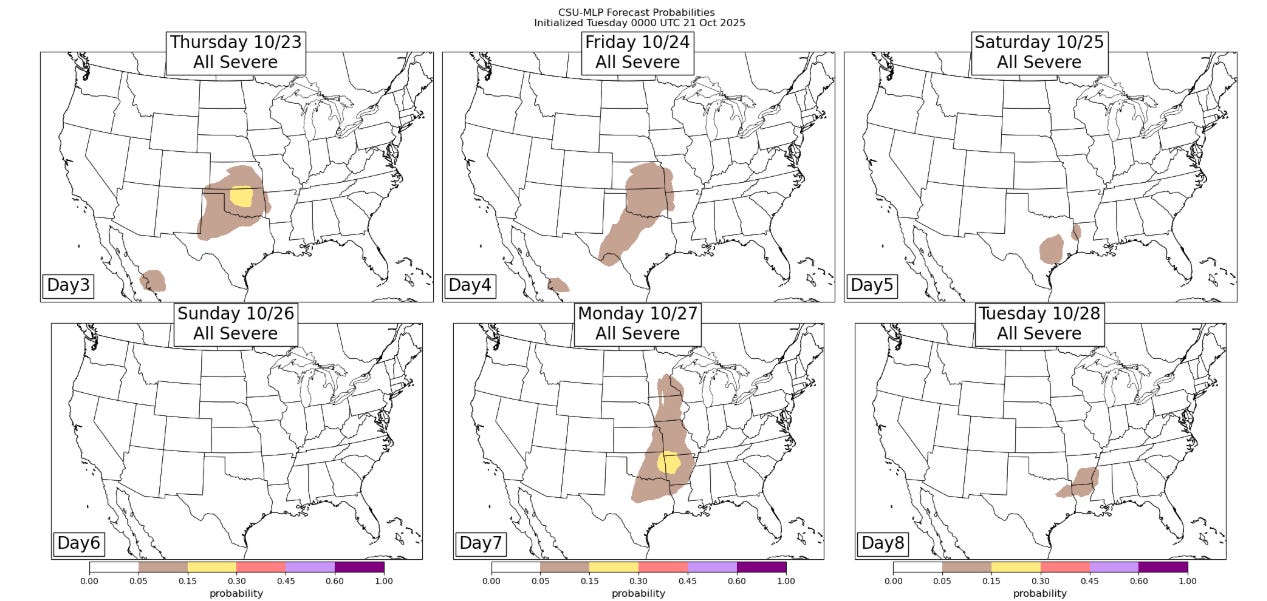
Stateside, the weather looks relatively quiet the next couple of days, but as the series of upper level low pressure storm systems I discussed above start to move across the south central US, some risk of severe weather (Colorado State University Machine Learning Probabilities shown above) and heavy rainfall looks to evolve late this week and into early next week. I will have more details on those risks in the coming days.

Leave a comment