Disastrous impacts from prolonged wind, storm surge and incredible rainfall with massive flooding and mudslides anticipated. Other regions of the Caribbean will also be seriously impacted.
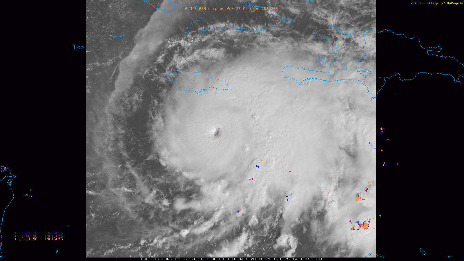
Morning visible satellite imagery this morning portrays an extremely ominous situation for Jamaica. Melissa has become a classic major hurricane centered about 100 miles due south of Kingston. With maximum sustained winds of 140 mph, Melissa is a category 4 hurricane on the Saffir-Simpson Hurricane Wind Scale (SSHWS). Melissa is yet another example of insanely rapid intensification of a tropical cyclone in the Atlantic, as it was a 45 mph tropical storm Friday evening and increased nearly 100 mph in intensity in about 36 hours.
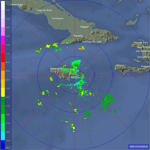
This ~36 hour loop of the Kingston radar from Brian McNoldy’s tropical radar page clearly shows how Melissa has intensified into a formidable hurricane is it moved west-southwest and then west to the south of the island. We can also see that waves of squalls have been moving west across the island bringing heavy rain and gusty winds — winds have been occasionally gusting to tropical storm force at both Montego Bay and Kingston the last couple of hours.

Unfortunately, the deteriorating weather conditions on Jamaica this morning are only a prelude to what looks to be an awful, devastating 48 to 72 hour period as Melissa moves agonizingly slowly west the next 24 to 48 hours and then turns north to move across Jamaica. This extremely slow movement will maximize the destructive potential of the hurricane, as intense winds and rainfall will be prolonged.
While the most recent reconnaissance aircraft mission found that Melissa appears to have reached a initial plateau as far as intensity, conditions remain favorable for strengthening and NHC is forecasting Melissa to be a category 5 hurricane at landfall in Jamaica. As noted by Michael Lowry in his excellent Substack post this morning, the most intense hurricane to strike Jamaica on record was Gilbert as a category 4 in 1988; Gilbert killed nearly 50 people and destroyed over 100,000 homes. Gilbert was a more typical “Caribbean cruiser” hurricane that moved across Jamaica from the east at a relatively rapid pace. Even if Melissa is not a category 5 hurricane at landfall — the actual intensity of the storm by that point will likely be dependent upon internal structural changes within the hurricane — the storm’s incredibly slow movement and the fact that it is coming up from the south means that it has the potential to be a more devastating storm to Jamaica than Gilbert.
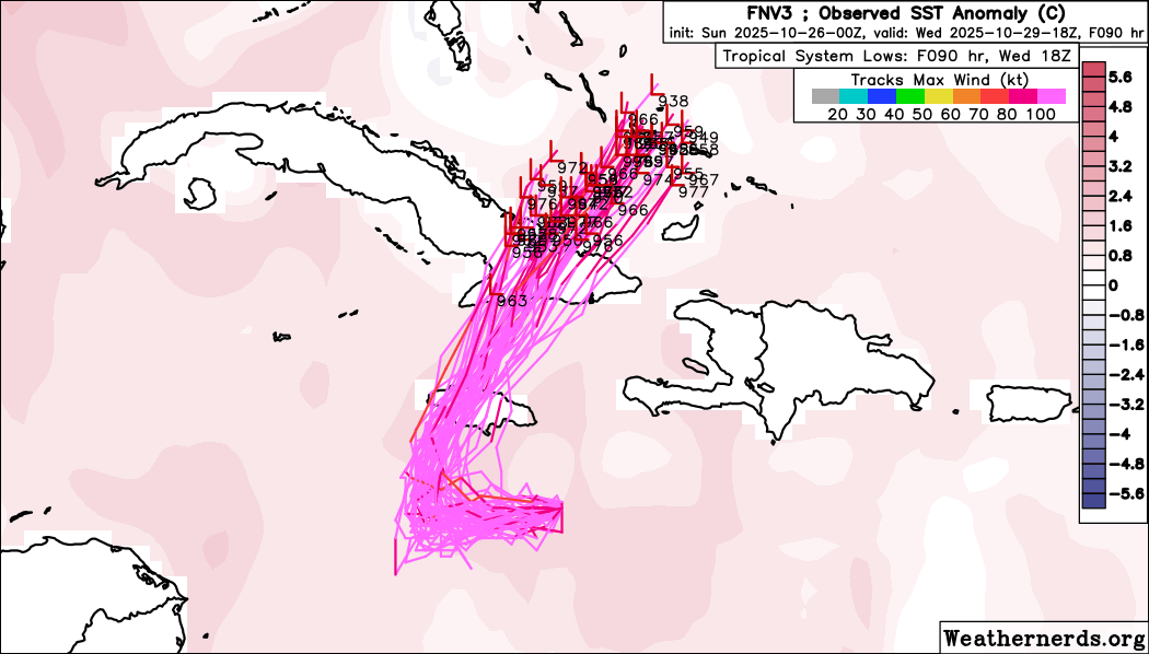
Alarmingly, recent trends in the models have shifted the track slightly more to the west, and most of the models (Google DeepMind ensemble shown above) now take Melissa across the central or western part of the island. If this track verifies, it means that much of the island will be exposed to the destructive core and/or more intense eastern side of the hurricane.
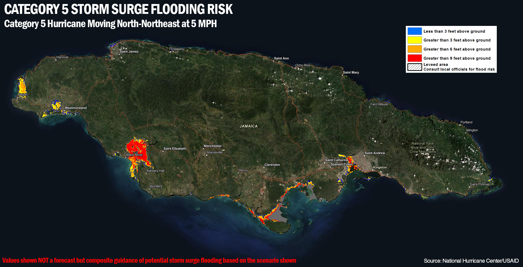
Additionally, most of the storm surge prone areas of Jamaica are on the south side of the island and will see maximum surge from a hurricane approaching from the south with the center passing just to the west. Areas along the coast near and just west of Kingston could be inundated by massive storm surge of 10’ or higher if the hurricane is a category 5 and passes to their west.
![[Image of rainfall potential]](https://substackcdn.com/image/fetch/$s_!FmAG!,f_auto,q_auto:good,fl_progressive:steep/https%3A%2F%2Fsubstack-post-media.s3.amazonaws.com%2Fpublic%2Fimages%2F25d88289-97e5-45c7-925f-705f1aaec6a6_3300x2550.gif "[Image of rainfall potential]")
Regardless of whether Melissa is a category 5 or a high end category 3 or somewhere in between at landfall, all signs are that this will be a devastating storm as bad or worse than Gilbert, which as noted above was the worst recorded hurricane in history for the island. Aside from all of what I have discussed as far as wind and surge, the rainfall will likely be the most devastating impact of all, with up to 40” of additional rainfall expected over the next 4 days across eastern Jamaica as the storm slowly meanders through the region. In the mountainous and urban regions of the island, this will obviously cause destructive, life-threatening flash floods and landslides.
![[Key Messages]](https://substackcdn.com/image/fetch/$s_!F5XS!,f_auto,q_auto:good,fl_progressive:steep/https%3A%2F%2Fsubstack-post-media.s3.amazonaws.com%2Fpublic%2Fimages%2F46297a5d-c9bf-4433-96b2-74bf1f353034_897x736.png "[Key Messages]")
While I have focused on Jamaica due to the extreme threat Melissa poses to that island, obviously this enlarging hurricane will have major impacts on other areas as well. Southern Hispaniola has already seen intense rainfall with serious and deadly flooding, and will likely see additional rainfall amounts of up to 15-20” over the next few days.
Melissa will likely weaken somewhat as its core passes over the mountainous terrain of Jamaica, but it is expected to still be a major hurricane when it moves over eastern Cuba. The timing of the hurricane’s move to the north and northeast is still somewhat uncertain, meaning that when the worst of conditions will occur in eastern Cuba and just how long the impacts will last on Jamaica is still somewhat unclear. However, as of now it looks like the worst conditions in Cuba will be sometime in the Tuesday to Wednesday time period.
After Melissa passes over Cuba, it will continue to move north-northeast across the eastern Bahamas and eventually threaten Bermuda late in the week. While conditions will be much less favorable for Melissa as far as intensity once it crosses Cuba, it is still expected to be a large and formidable hurricane with significant wind, surge and flooding impacts for the Bahamas — and will likely be at or near hurricane strength still as it makes its closest approach to Bermuda.
Luckily, the evolution of the upper level trough that will be controlling Melissa’s track this week is such that even the small probability of impacts to the Northeast that earlier models were showing has now disappeared as you can see illustrated by the most recent Google DeepMind ensemble forecast above. The Canadian Maritime region should probably be keeping an eye on Melissa just given how far out in time any nearby approach from the post-tropical system that Melissa will be by that point — but the risk even there appears pretty low.

Taking a quick look at weather over the US, the first in the series of storm systems for the eastern United States that will eventually turn Melissa to the north will be impacting the Southeast today with rain and thunderstorms. Flash flooding and a few severe storms are possible along the central Gulf Coast. The next upstream storm system will moving across the Western US, with some heavy mountain snows and valley rain showers.

Leave a comment