Hurricane conditions expected on Jamaica by sometime Monday, heavy rain and squalls continue there overnight.
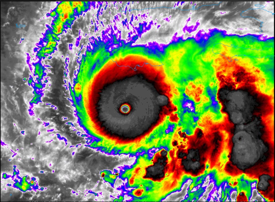
Good evening, I am going to be busy in the morning tomorrow, so I wanted to get out a bit more of a detailed post updating everyone with the latest on major Hurricane Melissa. Above is the most recent infrared satellite image of the hurricane — and unfortunately, I have to again say from a structural perspective, this is about as perfect of a satellite image of a hurricane as you will ever see. The eye is in the exact center of the hurricane and has very warm temperatures detected by the satellite, while very cold topped thunderstorms completely surround the eye.

To emphasize how impressive the structure of Melissa is this evening, the most recent objective satellite estimate using the Dvorak technique yielded a T-number of 8.0, which would imply a category 5 hurricane with winds of 170 knots (195 mph) and sub-900 millibar (mb) surface pressures. Reconnaissance aircraft has not found that intense of a hurricane to this point, with the most recent data as reported in the 10 pm CT NHC advisory having Melissa as a category 4 storm with max sustained winds of 145 mph and a minimum central pressure of 933 mb (27.55 inHg). Given the satellite presentation, though, it would certainly not be surprising for the next reconnaissance mission to find that Melissa is a category 5 hurricane.
![[Key Messages]](https://substackcdn.com/image/fetch/$s_!H0x1!,f_auto,q_auto:good,fl_progressive:steep/https%3A%2F%2Fsubstack-post-media.s3.amazonaws.com%2Fpublic%2Fimages%2F55e9c3f0-fdcf-478c-8475-a101c5efa822_897x736.png "[Key Messages]")
The forecast and impacts for Melissa are pretty much unchanged from what I discussed in this morning’s post. The eye of Melissa should continue to drift generally west the next 18 to 24 hours and then start to move north and northeast toward Jamaica. NHC continues to forecast Melissa to reach category 5 intensity before landfall in Jamaica as wind shear is forecast to remain light and obviously oceanic temperatures are incredibly warm. The actual intensity that Melissa makes landfall at will likely be governed by internal structural changes within the storm. Again, though, that intensity will mainly only matter for records as the impacts will likely be catastrophic regardless — particularly given the anticipated massive rainfall and flooding impacts.
After passing across Jamaica, Melissa will likely be weaker but should still be a major hurricane as it approaches eastern Cuba later on Tuesday or into Wednesday. It should be even a bit weaker but still a large, formidable hurricane as it then impacts the eastern Bahamas.
I will continue to post occasional short blurb posts, Substack notes, and BlueSky posts about Melissa as things evolve and time permits. I am planning a fuller update sometime later in the day Monday or Monday evening.

Leave a comment