Western and central Jamaica suffering catastrophic impacts
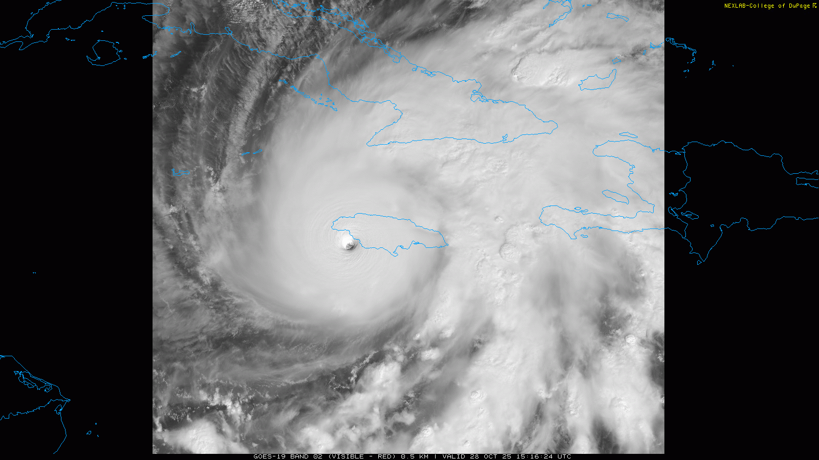
This visible satellite loop is literally one that will be in the meteorological history books. Hurricane Melissa is making landfall in western Jamaica just to the west of Black River Bay with a minimum central pressure of 892 millibars (26.34”) and maximum sustained winds of 185 mph. Assuming that the most recently measured 892 mb central pressure is what ends up being the final landfall pressure, Melissa would be tied with the 1935 Labor Day hurricane as the strongest landfalling hurricane by pressure ever recorded in the Atlantic basin. It is not hyperbole to say that western Jamaica is currently experiencing tropical cyclone impacts near the top of what is possible on this planet.

As an intense category 5 hurricane that has apparently not gone through an eyewall replacement cycle, the most intense winds will be right near the eyewall which will be passing across western Jamaica. The largest city in Jamaica, Kingston, will not experience these intense winds but strong winds will still occur — as of now, the highest wind gust reported there has been 59 mph.
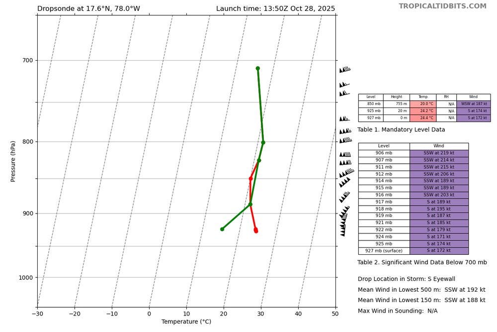
While 185 mph maximum sustained winds are estimated at the surface, even stronger winds will likely occur at higher elevations in western Jamaica. The data plot above is from dropsonde weather instrument released by a reconnaissance aircraft into the southern eyewall of Melissa this morning, showing measured winds of 215 knots (247 mph) just a bit above the surface. These stronger winds will likely impact higher terrain as the eye moves across the island. The previous benchmark hurricane for Jamaica was Gilbert in 1988, and it left areas of completely denuded landscape after its passage. Given Melissa is even more intense, similar or worse damage can be expected. As a side note, as reported on BlueSky by meteorologist Clark Evans, if the winds observed from this dropsonde are verified as accurate, these would be the strongest winds ever recorded on an Atlantic hurricane dropsonde.

The incredible intensity of Melissa combined with passing just west of this region and its angle approach from the south-southwest will unfortunately likely maximize catastrophic storm surge in the Black River Bay area, which as the map above shows is one of the most surge prone areas of Jamaica for a northward moving storm. Storm surge of more than 10’ will likely inundate large areas around this bay.
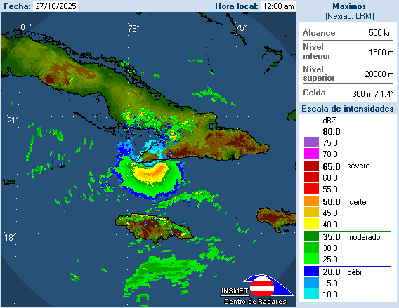
This multiday radar loop from the Pilon, Cuba weather radar from Brian McNoldy’s tropical weather radar webpage not only shows the approach of the eye of the hurricane, it also shows that waves of torrential rainfall have been moving across the entire island for many, many hours. Serious flash floods and landslides are likely already in progress and will continue to worsen in the coming hours as torrential rainfall continues.
While land and especially the higher terrain of Jamaica will help disrupt the core of Melissa and weaken it somewhat, it should still be a powerful hurricane producing intense wind damage as it reemerges off the north coast of Jamaica in the general area of Montego Bay. The NHC forecast currently shows Melissa as a 150 mph category 4 hurricane when it makes its anticipated second landfall in Cuba later tonight.
![[Key Messages]](https://substackcdn.com/image/fetch/$s_!okF2!,f_auto,q_auto:good,fl_progressive:steep/https%3A%2F%2Fsubstack-post-media.s3.amazonaws.com%2Fpublic%2Fimages%2F2ed8a531-5cb6-4222-b2ed-c6975dbbac71_897x736.png "[Key Messages]")
Devastating impacts from wind, surge and rainfall produced flooding are anticipated in eastern Cuba with this second landfall. While the hurricane will weaken even a bit more over eastern Cuba due to terrain and the start of increasing wind shear, Melissa should still be a powerful hurricane of at least category 2 intensity as it moves across the eastern Bahamas on Wednesday. Depending on the exact track and intensity, wind and rainfall impacts are likely on Bermuda Thursday into Friday while the weakening hurricane passes near the island.
I will continue to provide updates via Substack posts and notes as well as BlueSky posts as time permits today.

Leave a comment