Will pass west of Bermuda as a large category 2 hurricane later today; some impacts also expected for Atlantic Canada as Melissa moves past as a strong post-tropical storm.
For whatever reason, some tropical cyclones seem to be able to take whatever the atmosphere has to dish out as far as hostile conditions and continually rebound. Melissa was battered by shear early in its formative stages, but survived that and then went through one of the most intense and prolonged rapid intensification phases we have seen. After passing across the mountainous terrain of Jamaica, it was significantly weakened but almost immediately started reintensifying and was a strong, large category 3 hurricane when it made landfall in eastern Cuba several hours later.
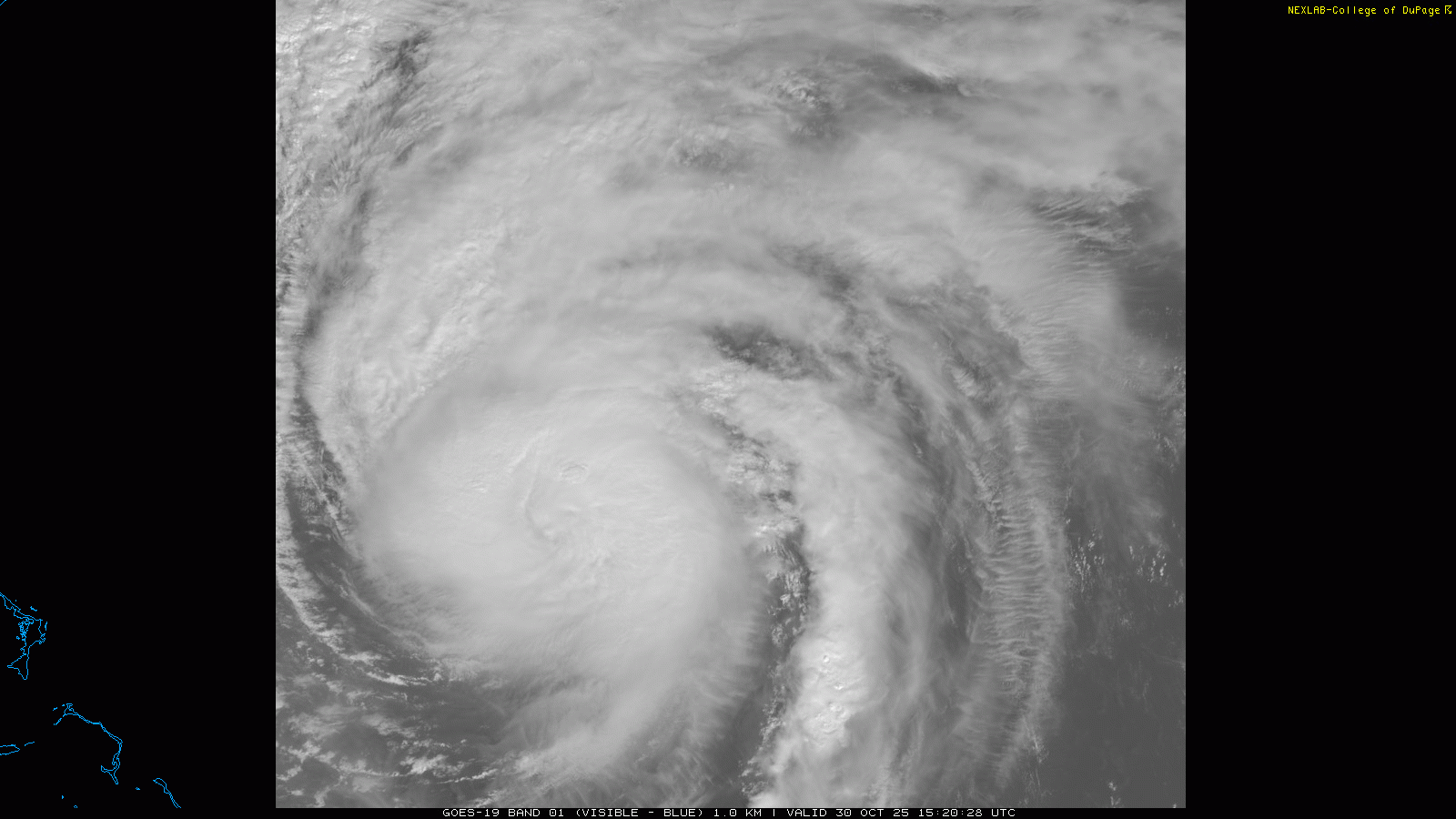
Then, after moving across Cuba, Melissa emerged into the Bahamas looking very disheveled. However, in the last 18 hours it has made a significant recovery once again in spite of increasing wind shear. While still nowhere near what it was like in the vicinity of Cuba and Jamaica, it has become better organized with an eye feature visible in satellite imagery and strong intense thunderstorm activity wrapping around the west and north sides of the eye. The most recent advisory from the National Hurricane Center pegs Melissa as a category 2 hurricane with maximum sustained winds of 105 mph and a central pressure of 965 millibars based on recent reconnaissance aircraft data.
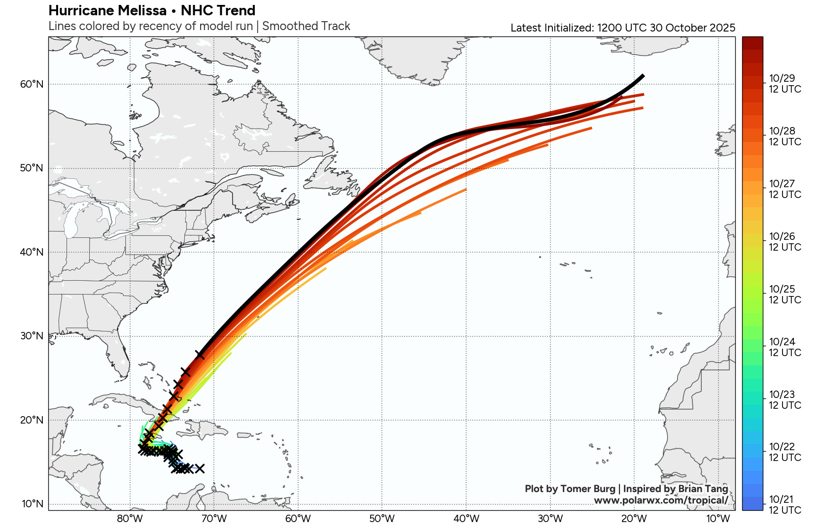
The very helpful NHC forecast trend graphic from Tomer Burg’s Polarwx.com shows how the forecast track of Melissa has been shifting west over the last few days. This means that impacts will likely be less in Bermuda than what was thought possible a few days ago, especially if the most intense thunderstorm activity continues to be on the north and west side of the eye. Obviously, we will be watching observational trends closely today to see how Melissa’s structure evolves and the exact track to monitor anticipated impacts for the island. A hurricane warning is in effect for Bermuda, and the hurricane should make its closest approach to the island tonight.

Once Melissa passes Bermuda, it will start moving over much cooler oceanic temperatures and wind shear will increase even further, meaning the storm should become post tropical relatively quickly. However, atmospheric conditions will support Melissa remaining an intense post-tropical storm system as it passes near the southeast tip of Newfoundland late Friday into Saturday morning. Strong winds and heavy rainfall are in the forecast for this region already due to a nor’easter, but the Canadian Hurricane Centre is anticipating enhanced wind and rain in eastern Newfoundland as Melissa makes its closely approach. They are also cautioning about the potential for heavier rain and possible coastal flooding on the Avalon Peninsula if the post-tropical storm moves a little farther west than forecast.
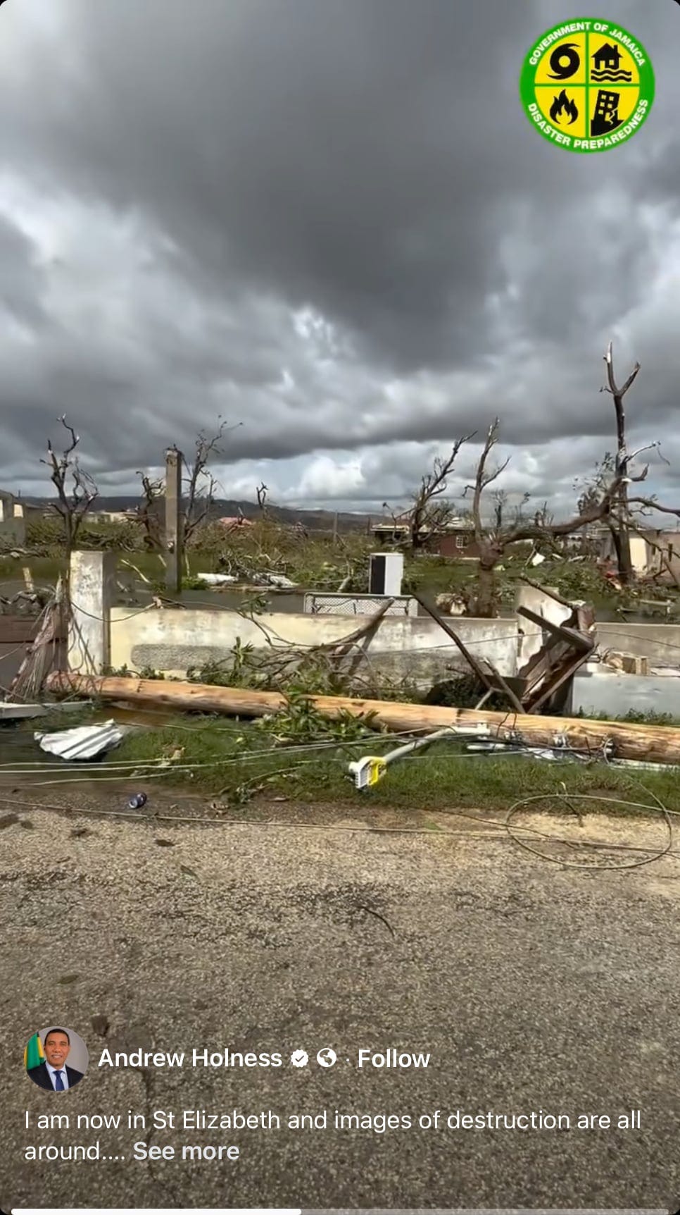
With regard to what Melissa has left behind, as I have been stressing it will take many days to start to get a picture of what has happened in the most impacted areas on Jamaica. However, the BBC is reporting that a Jamaican senator says that “entire communities have been marooned and areas seem to be flattened.” The above picture from a social media post by the Jamaican prime minister shows incredible wind damage in St. Elizabeth Parish that as a meteorologist reminds me of violent tornado damage. I fear that there are many scenes like this along the path of the eye of the storm as it tracked across western Jamaica from just west of Black River to east of Montego Bay. The one “positive” is that the lack of an eyewall replacement cycle in Melissa meant that the intense winds were very focused in and near the eyewall, meaning areas farther to the east including Kingston were spared the worst wind damage.
We are also only beginning to get a sense of the destruction caused by storm surge in Black River Bay where the surge was likely maximized, as well as the impacts of rainfall induced flooding. It is also important to recognize that while Jamaica was ground zero for this hurricane, many other areas of the Caribbean suffered disastrous impacts that will also take a long time to evaluate. Haiti reports at least 25 fatalities from catastrophic flash flooding that occurred due to days of intense rainfall produced by Melissa. In Cuba, the president reports that there has been considerable damage with the city of Santiago de Cuba being particularly hard hit.
Response and recovery in this region is just starting and will be a long haul. Time Magazine has put together a nice webpage with a list of non-profit organizations that will be working in Jamaica if you are interested in looking for a way to help.
Learn about other BalancedWx Services

Looking briefly at US weather, the nor’easter I talked about with regard to Melissa above will bring wet and windy weather to much of the Mid-Atlantic, Northeast and eastern Great Lakes regions today.

As that low pressure system moves Northeast, cooler air will overspread the eastern US, and some higher elevation snow will be likely in the Adirondacks and northern New England. The approach of new storm system to the Pacific Northwest will also bring wet weather there with some higher elevation snow.
Most of the country will be looking at a dry Halloween. Cooler than normal temperatures are expected over much of the country, but much warmer than normal conditions will persist over the Southwest. A few record high temperatures are possible in this region the next few days.

Leave a comment