Monday tropical deep dive focuses on the western Pacific
Good morning and happy Monday. Starting off this week with yet another canceled government contract impacting the availability of observations to the National Weather Service. Unlike with the Alaskan seismic data contract I posted about yesterday that was canceled by NOAA, this is a contract that the FAA has canceled for surface observations from airport sites, mostly in North Carolina and Maryland.
The NWS sent out a notice Friday afternoon stating that 58 observation sites would start disappearing that evening from their feed of surface observations due to the fact that “FAA is not renewing contracts with their third party vendor.” You can see the list of sites in the notice at the link above, but 42 of the 58 affected sites are in the state of North Carolina. Twelve are in Maryland.
Surface observation sites are so critical to meteorologists in performing their warning and forecast services — not just to the NWS, but to all of public and private sector meteorology. Remote sensing technology like satellite and Doppler radar provide incredible real-time information to meteorologists about what is happening in the atmosphere, but generally speaking, meteorologists have to imply what is happening at the surface based on that remote sensing data. We still need ground truth observations at the surface to confirm what is actually happening, and of course this observational data is also needed for numerical weather models. Aviation surface observations from airports around the country are still one of the primary, gold standard sources of this critical weather data.
Airport surface weather observations have long been a joint responsibility of the National Weather Service and the Federal Aviation Administration (FAA), as obviously both of these entities have a critical need for this data to meet their mission. In my career as a meteorologist, these agencies have worked together to add hundreds of new observational sites around the country which has made a big positive impact on weather forecasting and warning in recent decades.
The idea that we are now clearly headed the other direction is very disappointing. The idea that we are going to lose 42 sites from a state the size of North Carolina and 12 from a state the size of Maryland is almost unfathomable, as this has to be a significant percentage of the previously available aviation observation sites — I would guess at least half for each state. While of course none of the major commercial airports are affected here, there are some sites that even I have used pretty regularly in my national work, such as College Park Airport and Frederick Municipal Airport in Maryland. I obviously would defer to my colleagues those who routinely forecast for those states on the potential impact of the loss of these sites, but it seems substantial.
This is just another stage in the erosion of our federal weather infrastructure, and in the area of surface observations comes on the heels of the NWS and FAA deciding to transition 207 sites around the country from Automated Surface Observing System (ASOS) sites to Automated Weather Observing System (AWOS) sites rather than the next generation of ASOS. ASOS is the gold standard observation system that provides not only the data needed for hourly weather and aviation monitoring, it also provides higher temporal resolution data and sensors for climate monitoring (e.g., precipitation totals) that AWOS-C does not. Per the NWS webpage about this transition:
The FAA funding budgeted for this upgrade is insufficient to recondition all 570 FAA ASOS locations to the modernized processing and dissemination integrated systems. The decision to transition to the AWOS-C in lieu of ASOS 2.0 was therefore a budgetary decision by the FAA.
While AWOS-C may meet the basic requirements of the FAA for weather observations, transitioning from ASOS to AWOS-C is definitely a step backwards with regard to NWS needs as far as forecasts/warnings and climate monitoring. Again, as I discussed yesterday about the Alaskan seismic data and tsunami warnings, in my opinion federal entities should be funded to be able to meet their mission requirements. To be fair, NWS was already under serious budget strain prior to 2025, both due to actual appropriations but (in my opinion) also due to their own unwillingness to seriously pursue organizational changes that would have reduced built-in, must-pay costs to the agency. Regardless, the budgetary situation will likely only get worse for NWS and — especially — other key federal agencies in the federal weather and water infrastructure given the current environment in Washington.
While airport aviation weather observations are the national “gold-standard” for surface observations, they are obviously not the only source of surface weather data, with a variety of sources offering differing levels of quality and data quality control. The other source of high quality data that has been growing in recent years are state mesonets, surface observation networks operated at the state level for a variety of needs. The renowned Oklahoma Mesonet, which has at least one high quality surface observing system in every county in the state as well as a robust data quality and visualization program, was the first, groundbreaking state mesonet started in the early 1990s. Over the intervening years, many other states have started mesonets, and now NOAA/NWS has a National Mesonet Program — which grew out of Congressionally authorized projects and other grassroot efforts — to help coordinate and encourage the development of state (and local) mesonets.
Obviously, state and local entities have their own needs for weather and water data, and there should be a strong collaboration between federal, state and local entities to help develop observing systems of mutual benefit. However, that should not replace the requirement for federal entities to support the basic level of observations needed to provide robust warning and forecast services, and I worry that what I have discussed over the last two days with seismic data and surface observations show that we are continuing down a road towards not meeting those basic requirements.
Furthermore, I am very concerned we are on a slippery slope where the quality of important governmental services such as weather forecasts and warnings will become less dependent upon a standard of service provided by the federal government and more dependent upon which state or locality you are in. For example, in the wake of the tragic July Hill Country floods, the state of Texas appropriated $28M for state-focused improvements to atmospheric monitoring and numerical weather prediction, and there have been increased calls in the state for state-led improvements to weather forecast and warnings services.
Again, while I am not opposed to any efforts that improve forecast and warning services, I do think we have to be cognizant that focusing on state or local improvement efforts could leave us in a situation where people in states with more resources (e.g., Texas, Florida, California) may be getting better warnings than people in other states — and that this doesn’t just apply to residents, it applies to people who are visiting those areas. Perhaps this is the overall strategy our country wants to pursue when it comes to weather services — but I think it is important that we fully understand the implications of making that decision before heading down that road.
Learn about other BalancedWx Services
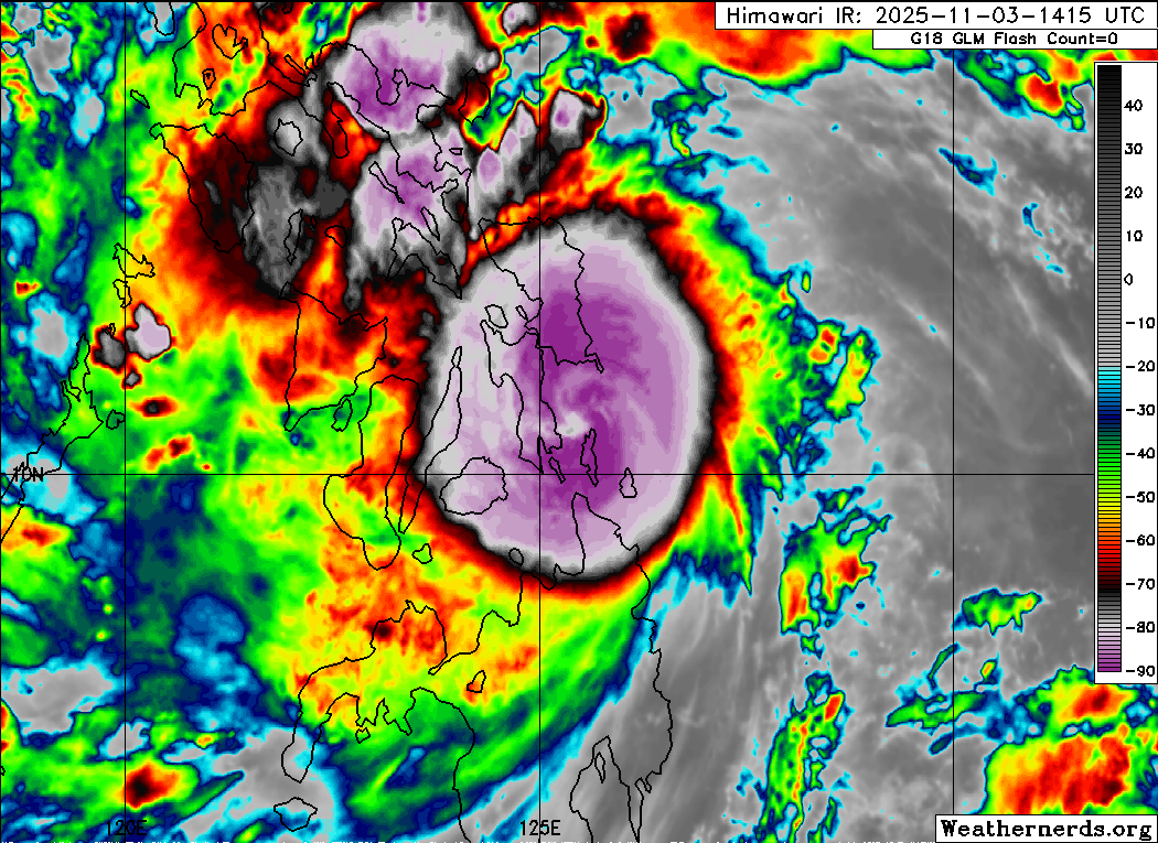
Since Monday is usually my tropical focused newsletter, I want to start off on the weather section of today’s post by looking at Typhoon Kalmaegi, which in the last couple of hours has made landfall in the central Philippines. As expected, Kalmaegi intensified to a category 2 equivalent typhoon prior to landfall, and could have been a little stronger given that satellite trends showed continued intensification right up to landfall, including with an eye starting to become visible in infrared imagery. Obviously, without reconnaissance data we do not have an exact intensity, but certainly significant wind, storm surge and rainfall is impacting the central Philippines currently. The Associated Press reported that more than 150,000 evacuated in the region ahead of the landfall.
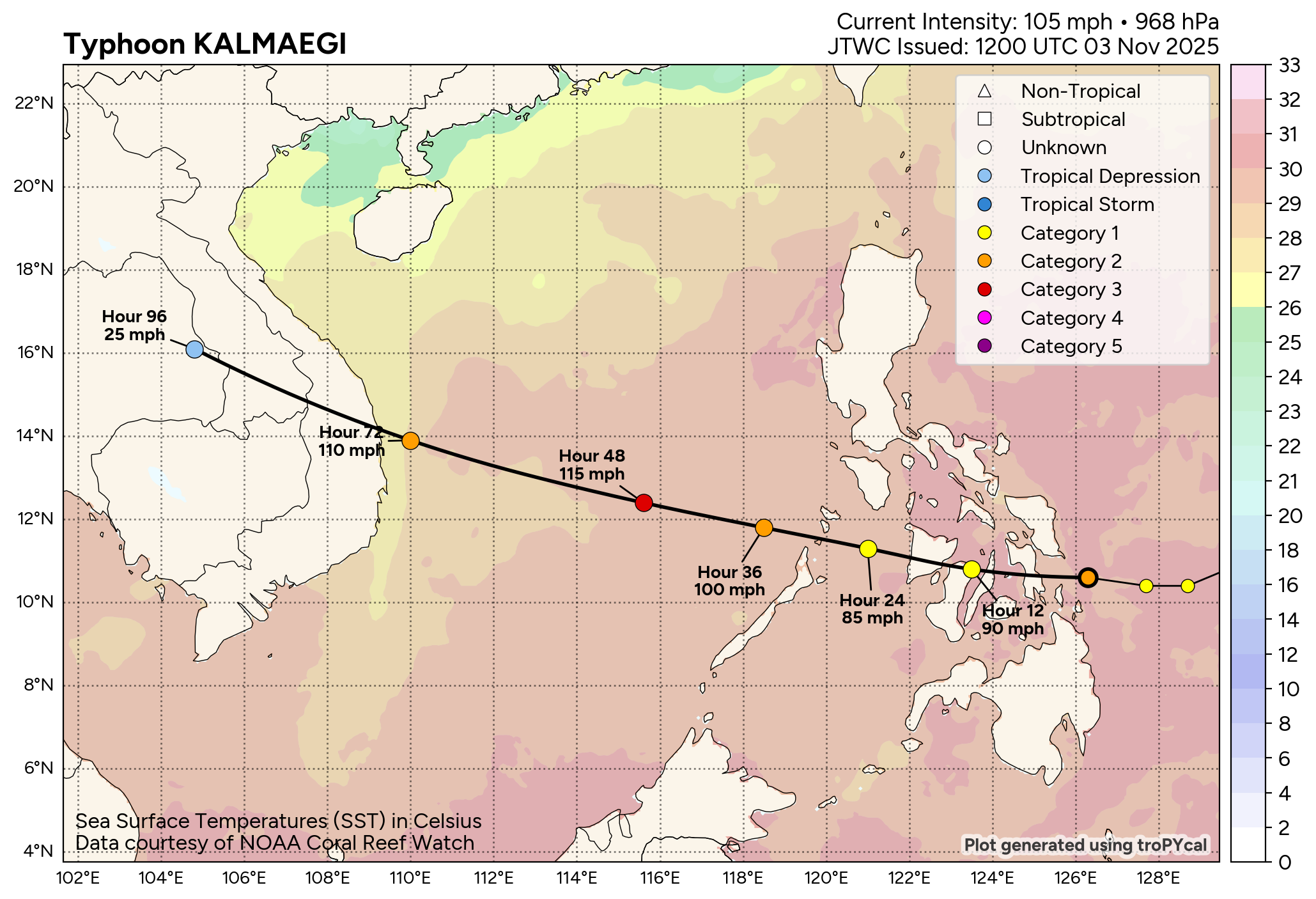
While Kalmaegi will weaken somewhat as it passes over the islands of the Philippines, it should reintensify as it moves west across the South China Sea, and is likely to reach the equivalent of major hurricane intensity. It may weaken a bit prior to landfall in Vietnam but should still be a powerful typhoon with significant impacts when it makes landfall in a few days.
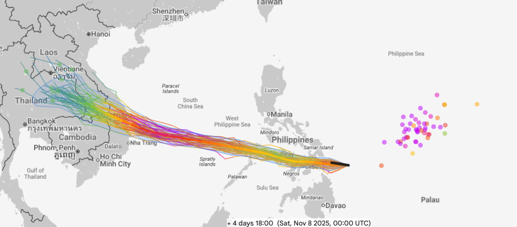
Another system (Invest 90W) is developing well east of the Philippines today, and the Google DeepMind AI (GDM) ensemble shows this system developing into a powerful (equivalent to category 4 or 5 on the Saffir-Simpson Hurricane Wind Scale) by the end of this week as it moves west. Longer range forecasts begin to show more uncertainty in the track of this system, but it certainly could pose a threat to the northern Philippines by this weekend. This can still be a busy time of year in the western Pacific with some of the most devastating supertyphoons happening in November and December, so we will be watching all of this closely.
The western Pacific looks to be the global tropical focus for the next two weeks as there is still little sign of anything brewing in the eastern Pacific or Atlantic. A few members of the GDM ensemble show development in the western Caribbean in week 2 — but given that this is the climatologically favored part of the basin at this time of the year, seeing that noise level of development is not surprising. We will of course keep watching.
Obviously, we do not want to forget the humanitarian disaster ongoing in Jamaica and surrounding islands after Melissa. These BBC videos from on the ground and in the air give compelling perspective on what people in western Jamaica face. The death toll in the Caribbean region has risen to at least 60, including 28 in Jamaica and 31 in Haiti. The prime minister of Jamaica continues to warn that the toll there will likely continue to rise.
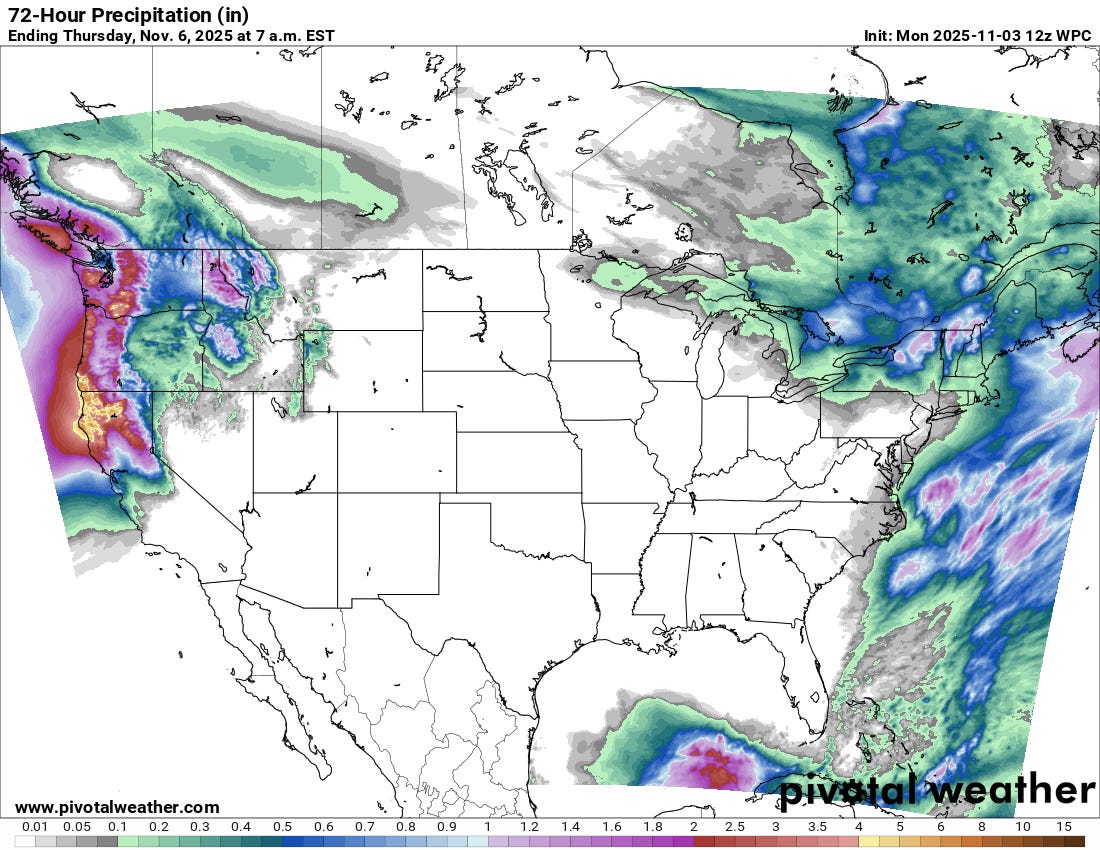
Stateside, most of the country will be quiet the next few days, with the primary exception being in the Pacific Northwest, where a series of storm systems will bring waves of heavy rain and some (very) high elevation snowfall. A number of record high temperatures were set in the western half of the country on Monday, and unseasonable warmth will be gradually spreading east through the week.
Note: The US weather community relies on the work of NOAA scientists who are exempt from the ongoing federal furlough due to the life-saving nature of their work. These federal employees are in their 34th day of working without pay and without knowing when they will eventually receive pay. You can read more about this situation in this post.
Balanced Weather is made possible by the generous support of paid subscribers, who as thanks get access to live Balanced Weather chats and videos as well as the ability to post comments and ask questions on posts. To become a paid or free subscriber, click below:

Leave a comment