Kalmaegi intensifying as it approaches Vietnam, and next system still looks to be a major threat to northern Philippines.
Nov 05, 2025
I am sure that all of you have heard about the tragic crash of a UPS cargo flight at Louisville International Airport last evening. My also recently retired NSSL colleague Ken Howard shared with me a fascinating (and terrifying) loop of mosaicked radar reflectivity data from the Multi-radar Multi-sensor (MRMS) system that shows the explosion from the crash and the resulting smoke and debris plume expanding downstream.
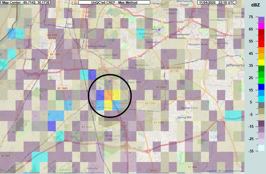
Looking at this in more detail, the 5:18 pm ET reflectivity product — 3 minutes after the approximate time of the crash per media reports — shows high (greater than 45 dBZ) values that would typically be associated with heavy rainfall if the radar had been detecting weather phenomena (note that you can see the airplane icons for the airport runway locations on the map above). In this case, the radar is detecting debris and particulate matter from the crash and resulting explosions being lofted into the atmosphere — the aircraft was fueled for a long-haul flight to Honolulu.
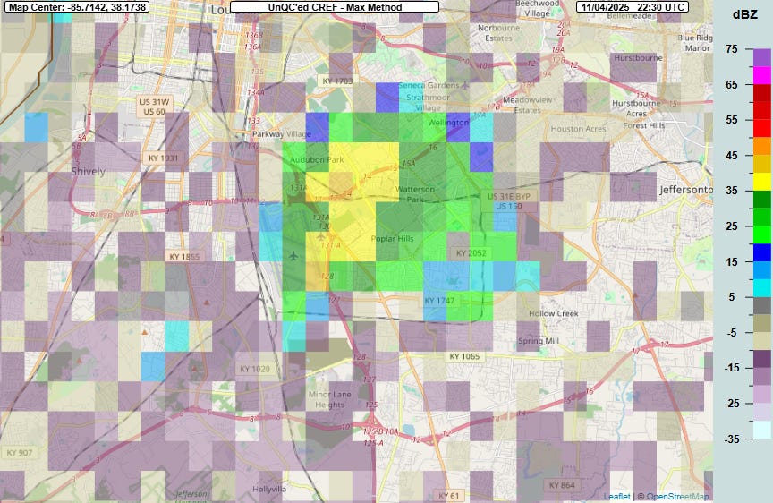
By 5:30 pm ET, the higher reflectivity is starting to spread to the northeast as the smoke and particulates are carried downstream by south-southwest winds into a large plume that was visible in media coverage of the tragedy.
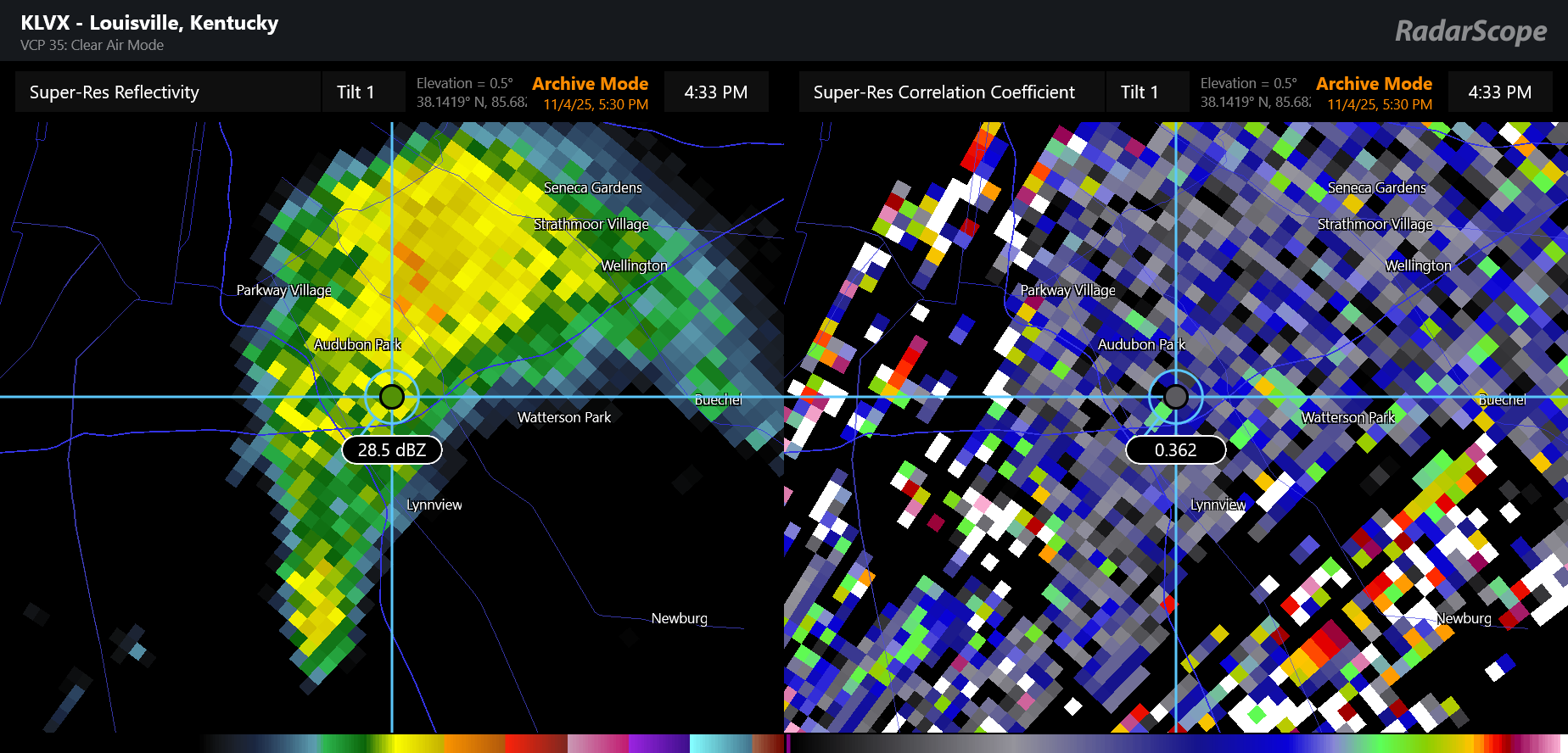
If along with the radar reflectivity data we look at dual-polarization radar data from the Louisville radar, the correlation coefficient data confirms that what the radar is detecting is some mixture of smoke, debris and particulate matter. Correlation coefficient is essentially detecting the size and shape of the objects the radar is detecting, and the fact that the values are low shows that what the radar is “seeing” are varying significantly in shape and size, meaning they are unlikely to be weather echoes. This is the same general signal we look for in the radar data to see a tornadic debris signature.
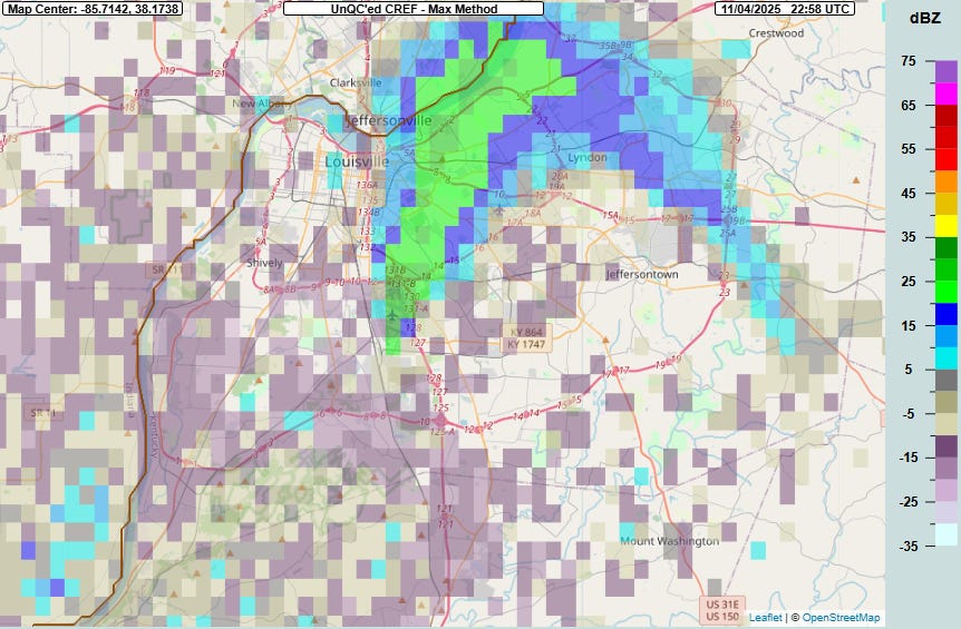
By 6 pm ET, the reflectivity values are lowering and continuing to expand to the north-northeast as the plume fans out. Over the next hour the plume continues to fan out and it pretty much dissipated by 7 pm ET.
I wanted to share this to demonstrate how the our national NEXRAD (WSR-88D) Doppler weather radar network has utility well beyond its weather reconnaissance mission. Data such as this can be highly useful to emergency managers and firefighters as they respond to these sorts of catastrophic events. In similar events when hazardous materials are involved, National Weather Service meteorologists can utilize radar data to provide decision support to these entities to help them as they work to keep the public safe.
Other similar non-weather applications include tracking space debris — NEXRAD radar played a crucial role in the response and investigation of the space shuttle Columbia disaster, and ongoing research at the National Severe Storms Lab and University of Oklahoma is investigating similar applications of weather radar data today to help warn the public of potential dangers from deorbiting space objects. Obviously, the NEXRAD weather radar network is a crucial national resource for monitoring weather and water hazards, but applications such as these show its tremendous versatility and applicability and demonstrate why it is so important for it to be kept robust.
On a completely different and much more positive note, I have an update on the situation I reported on Monday with regard to a large number of aviation surface weather observations in North Carolina and Maryland becoming unavailable. Even though the notice the NWS sent to users stated that the observations were being lost due to the cancelation of an FAA contract, colleagues with contacts within the FAA have reported to me this morning that the issue here is that the private entity that was responsible for transmitting the data for the 58 observation sites in question has actually went out of business. These sources report that the FAA is working to identify new entities that can provide this service. In fact, the FAA has already identified a new data provider for the North Carolina sites and is hoping to find a new provider for the Maryland sites soon, so the missing data should hopefully only be a temporary situation.
Obviously, this is much more positive than the initial NWS notice made the state of affairs sound — and I am glad to be able to report something positive for a change within the realm of federal weather and water data availability. However, I will also point out that this situation suggests seriously confused communication occurring within the federal agencies, and confirms what I have been hearing from colleagues still in these federal agencies about a very chaotic environment. Certainly the shutdown is not helping any of this, as I am sure that has left a number of employees within NOAA, FAA, etc. who handle things like project management and contract renewals on furlough. Hopefully at least that aspect of the challenges facing the federal agencies will be resolved sometime soon.
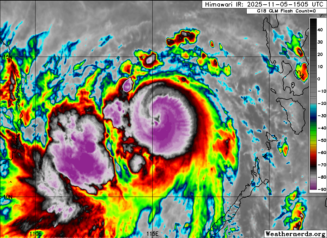
Turning to weather, Kalmaegi has reintesnified as forecast, and is now at an intensity equivalent to a category 2 hurricane on the Saffir-Simpson Hurricane Wind Scale with maximum winds of 105 mph. Infrared satellite data above suggests that Kalmaegi may be intensifying further, as the eye has continued to become warmer and more centered within the thunderstorms around the center, all signs of intensification. The automated satellite intensity estimates that we talked about during Melissa are also going up fairly rapidly. It certainly would not be surprising to see Kalmaegi make category 3 intensity before it starts to encounter less favorable environmental conditions just prior to landfall in central Vietnam, which should occur about 24 hours from now and could seriously exacerbate ongoing flooding impacts there. Sadly, the death toll from Kalmaegi in the Philippines has reached at least 90.
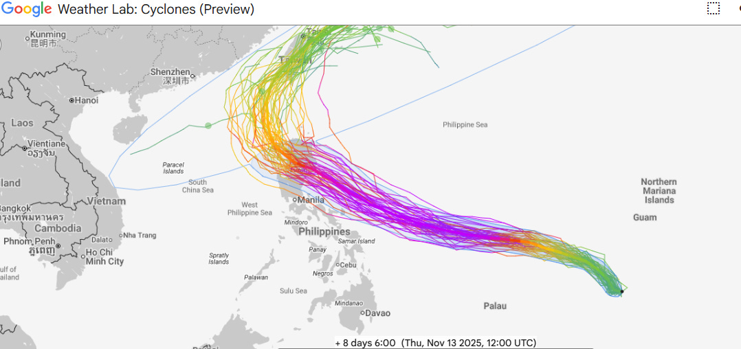
The system trailing behind Kalmaegi is still an organizing tropical depression to the southwest of Guam this morning, but continues to look to be on track to intensify — potentially into a super typhoon — as it moves west-northwest over the next several days. Both the Google DeepMind AI and PolarWx grand ensemble continue to suggest the most likely scenario is for the landfall of an intense typhoon in Luzon late this weekend (US time).

Stateside, the series of storm systems will continue to bring rain and mountain snows to the Northwest today, while a weaker storm system will bring rain showers and higher elevation snow showers to the Northeast. Unseasonably warm conditions will continue over much of the country today after several record highs were set on Tuesday, including Amarillo, TX reaching 89F and breaking their more than 100 year old daily record high temperature by 4 degrees.
Note: The US weather community relies on the work of NOAA scientists who are exempt from the ongoing federal furlough due to the life-saving nature of their work. These federal employees are in their 36th day of working without pay and without knowing when they will eventually receive pay. You can read more about this situation in this post.

Leave a comment