Fung-Wong now a typhoon and still expected to impact northern Philippines. And an update on Michelle and Kalmaegi impacts.
Nov 07, 2025
My weather content the last couple of weeks has been dominated by the tropics given the tremendous impacts of Melissa and Kalmaegi. I will definitely be continuing to focus on the western Pacific the next few days as Fung-Wong looks set to cause major additional impacts to the Philippines — more on all of this below — but I do want to start off this Friday morning talking about US weather with the first big shot of cold air on tap for the East this weekend.
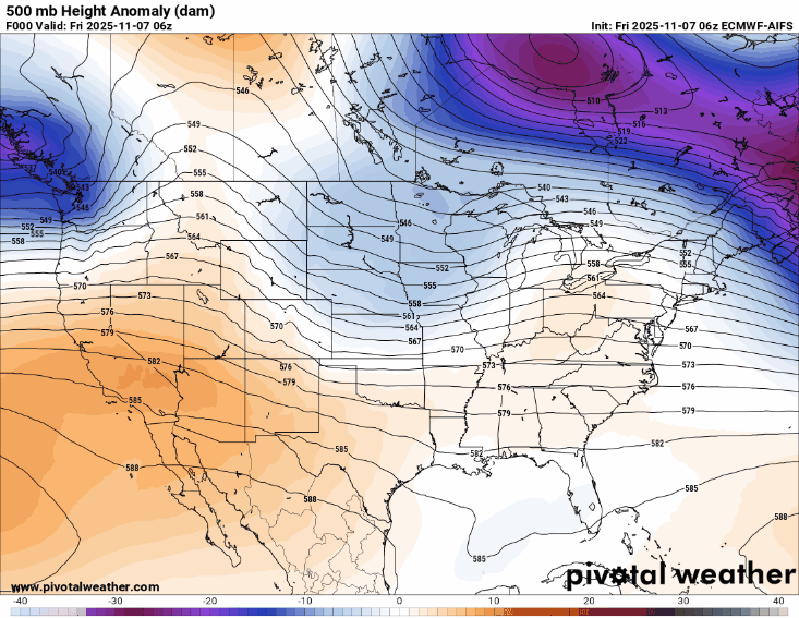
The evolution of the weather pattern in the middle and upper levels of the atmosphere is what is driving this outbreak of cold air. To illustrate that, above I have a loop from the most recent European AI model of the heights (similar to isobars, i.e., pressure lines, on a surface weather map) at 500 millibars — about 18,000 ft AGL. The image is how the heights are differing from normal, i.e., blue is where there is lower than normal heights and shows upper level troughs of low pressure, while orange/red shows above normal heights and areas of upper level high pressure.
What we can see in this forecast loop is that a series of disturbances will carve out an unusually strong upper level area of low pressure over the eastern United States that will reach its peak in intensity early next week. Meanwhile, upstream an unusually strong ridge of high pressure will build across the western half of the country.
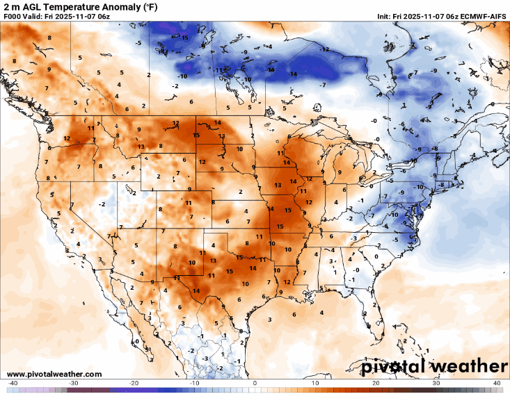
The implications of this at the surface — where we live! — is that the strong upper level trough will help unseasonably cold air plunge south. The position and intensity of the upper level trough will enable this cold air to move all the way down into the Deep South and Florida, the region which will actually see the largest cold anomalies — temperatures up to 25F below normal — and most numerous record cold temperatures.
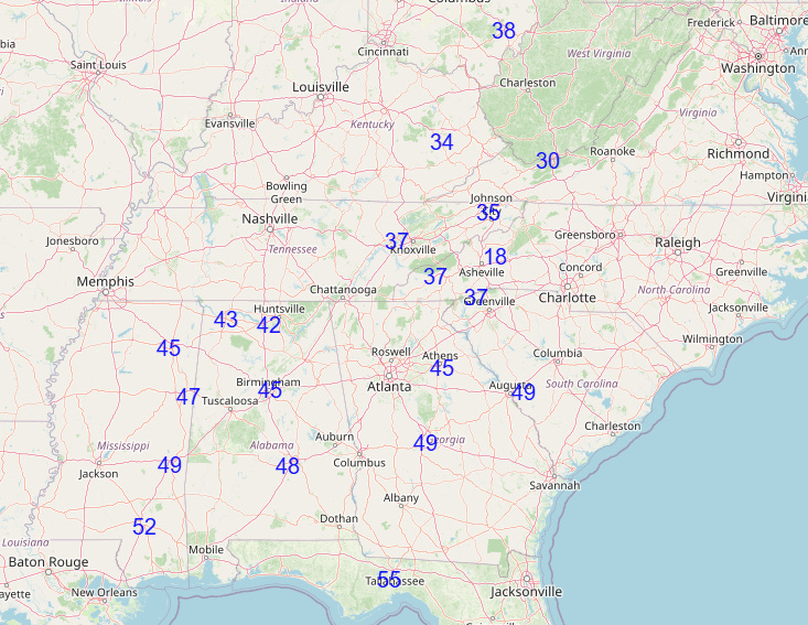
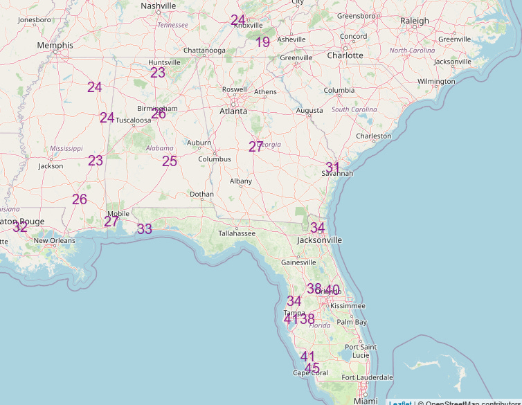
Monday into Tuesday should see the coldest temperatures, with numerous forecast record low maximums (top graphic) and record low minimums (bottom graphic). Low temperatures in the 30s will be possible all the way south to the I-4 corridor in central Florida. While this is certainly unusually cold air for this early in the season, it is not near monthly cold records given that we are early in the month and colder temperatures have occurred later in November. I did a spot check on several locations to see how this compares to all-time cold records for the first half of November, and from what I saw the forecast temperatures for early next week still look several degrees above those readings as well.
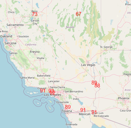
Meanwhile, under the upper level area of high pressure in the west, unseasonable warmth is expected, and a number of record high temperatures are expected on Monday in parts of Nevada, California and Arizona.

Looking at the 500 millibar forecast again, we can also see that even though the upper level trough driving the cold air outbreak is intense, it is also what meteorologists refer to as “progressive,” meaning that it will move east quite quickly.
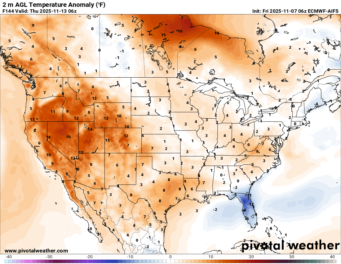
This means while it will be unusually cold, it will be short-lived, and by midweek the temperature anomaly map shows that most of the country (except Florida) will be back to near or above normal over most areas.

As far as precipitation risks, the first disturbance and cold front moving through the East today will bring scattered to numerous showers and thunderstorms to much of the eastern third of the country. A few severe storms are possible from the Tennessee Valley to the central Gulf Coast, with the greatest risk over middle Tennessee and south central Kentucky where the Storm Prediction Center has a slight (level 2 of 5) risk area. Damaging wind gusts are the primary severe weather risk.
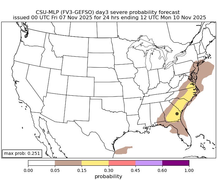
Additional thunderstorms are expected in the Southeast this weekend, and as another stronger upper level disturbance moves through the region on Sunday, a risk of severe thunderstorms could evolve in coastal areas from the Tidewater to southern Georgia as shown by the Colorado State University Machine Learning Probabilities system above — the forecast level of probabilities are equivalent to a level 2 of 5 risk from SPC.
As we go into Sunday and the early part of the new work week, the cold air streaming across the Great Lakes will result in increasing lake effect snow downwind of each of the Great Lakes. On Sunday the typical lake effect areas downwind of lakes Superior and Michigan look to see the more significant snow with several inches of snow possible. Lakes Erie and Ontario look to be the focus Monday into Tuesday, and the Tug Hill plateau of upstate New York looks set to get their first big heavy lake effect event of the winter.
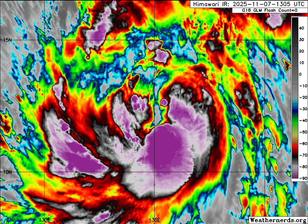
Turning now to the tropics, Fung-Wong (above) has continued to get better organized over the last 24 hours, and is now a minimal typhoon with maximum sustained winds of 75 mph.
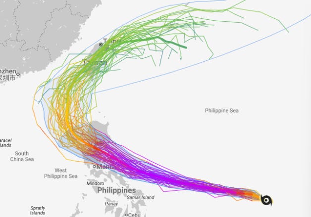
The forecast for Fung-Wong at a high level is still on track. It is expected to intensify into a major typhoon, potentially reaching super typhoon levels (equivalent to at least a strong category 4 on the Saffir-Simpson Hurricane Wind Scale) as it moves west-northwest toward the northern Philippines.
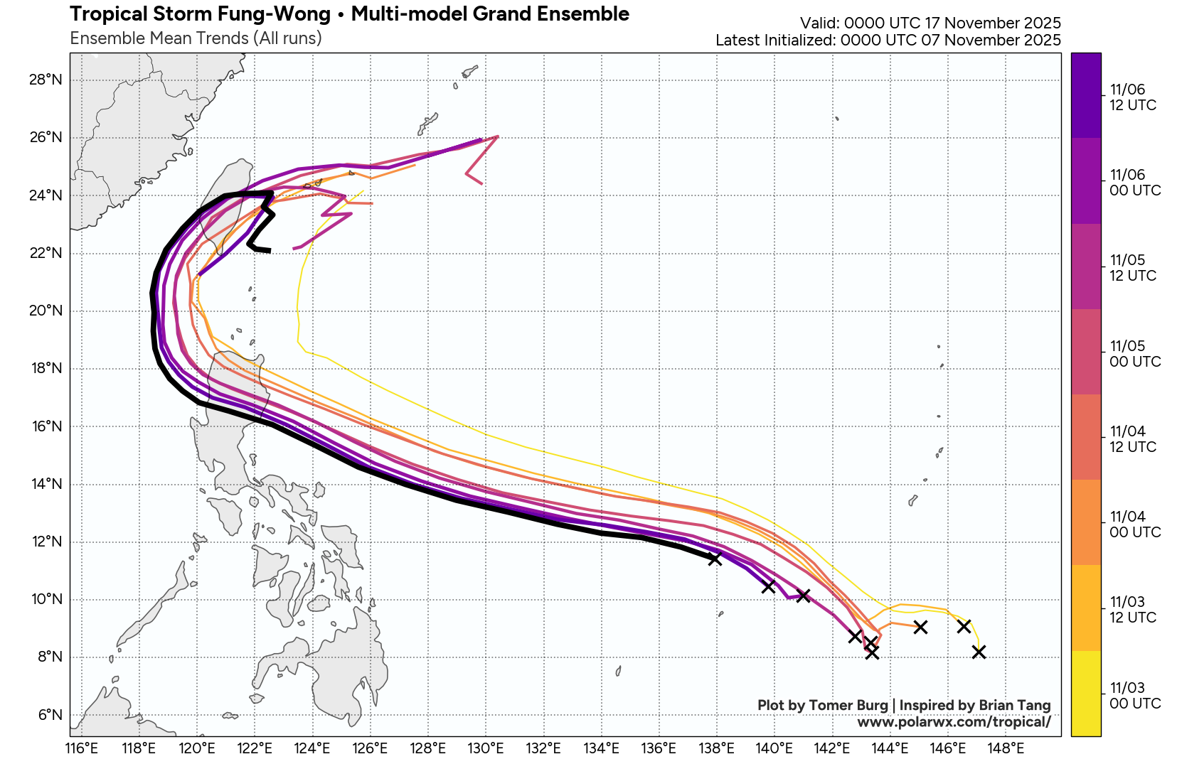
The most important noticeable change in the forecast has been a trend toward a farther south track in Fung-Wong (known as Uwan in the Philippines). This is an important trend as it could bring impacts from the typhoon farther south into the more heavily populated areas of Luzon (the large northern island of the Philippines), including the Manila metro area which is now along the southern fringe of the ensemble tracks for Fung-Wong.
This trend is particularly concerning given that the Philippines is already in the midst of a major response to the catastrophic damage left in the central Philippines by Kalmaegi. The death toll from Kalmaegi in the Philippines has now reached 188 with numerous people still missing. Philippine President Ferdinand Marcos Jr. said, “We suffered many deaths, it was very grave. The biggest problem we’re seeing (now) is, we have to think who and how many of the personnel now handling government relief and support in the central Visayas region can be shifted to prepare for Uwan.” Fung-Wong (Uwan) should make landfall on Luzon sometime on Sunday (US time).
Damage from Kalmaegi is still being assessed in central Vietnam where the typhoon made a second landfall about 24 hours ago; as of now, 3 people are confirmed dead and a number are missing. Of course, we also do not want to forget the ongoing crisis in Jamaica and surrounding islands left by Michelle. The Guardian reported yesterday that many people in western Jamaica are still waiting for aid and need food, water and shelter. The United Nations Office for the Coordination of Humanitarian Affairs (OCHA) reports that while the death toll remains at 32 in Jamaica, an unknown number is still missing and that many areas remain difficult to access. Distressingly, they also reported that many displaced families are leaving official shelters due to limited access to relief. Again, this USA Today link has a list of non-profits working in the region if you are interested in helping with recovery in the Caribbean.
Note: The US weather community relies on the work of NOAA scientists who are exempt from the ongoing federal furlough due to the life-saving nature of their work. These federal employees are in their 38th day of working without pay and without knowing when they will eventually receive pay. You can read more about this situation in this post.

Leave a comment