Record cold gives way to warmth and signs of an increasingly stormy pattern for western and central US
Nov 11, 2025
Yesterday afternoon, the Chancellor of the University of Nebraska-Lincoln (UNL) announced his final proposal to make budget reductions to deal with a growing financial shortfall for the university. This final proposal includes elimination of the Earth and Atmospheric Sciences (EAS) program at the university, including all degrees and associated minors in meteorology, climatology, geology and earth and atmospheric sciences. Yesterday’s finalized plan comes after an initial plan was announced in September and opened to feedback from the university community. The university’s Academic Planning Committee provided input on the initial plan and rejected the elimination of the EAS program; however, the final plan submitted to the university’s board of regents moves forward with the program’s elimination. The UNL Board of Regents will vote on the final proposal December 5.
Assuming the program’s elimination is approved, this will make the second long-time university atmospheric sciences program to be eliminated in recent months, joining St. Louis University (SLU, my undergraduate alma mater) which announced in April that it was eliminating its meteorology program. The growth of university meteorology programs during my career has been dramatic; while estimates vary based on what one exactly counts as a meteorology or atmospheric sciences program or degree, somewhere in the neighborhood of 100 different universities and colleges have an undergraduate or graduate degree program in this field.
University of Georgia professor John Knox did a seminal study in 2008 that showed that the numbers of meteorology graduates was growing much faster than demand, and while that demand has likely continued to grow in the years since, so has the number of meteorology programs. Hence, it is not a big surprise to me that we are seeing some contraction in atmospheric science programs, especially given the current federal science budget climate.
What concerns me, though, with the loss of Nebraska and St. Louis University is that we are losing storied meteorology programs that have a rich history of developing talented scientists and performing important research. A number of my colleagues at the National Severe Storms Laboratory earned at least one of their degrees at UNL. UNL’s atmospheric sciences program has been a major contributor to recent severe weather research projects, including serving as the lead institutions for the NSF funded Targeted Observations by Radars and UAS of Supercells (TORUS) severe storms field research project that ended in 2022.
Meanwhile, I am admittedly biased in my perspective of St. Louis University, but in my opinion it has been one of the atmospheric sciences programs during my career that has most focused on performing research on operational forecasting problems. This work started with the late Dr. Jim Moore and his focus on the use of isentropic forecast techniques and improving forecasts of mesoscale convective systems through the Cooperative Institute for Precipitation Systems (CIPS). Dr. Chuck Graves took over the leadership of CIPS after the passing of Dr. Moore, and under his leadership the CIPS Analog system was developed. This system was an early effort to prototype the types of analog forecasting approaches that are now being able to fully leveraged using AI, and this system has been used extensively by NWS forecasters and other meteorologists for more than a decade. SLU’s focus on operational topics has led to a number of graduates playing key leadership roles in NOAA and the NWS, and in September Dr. Graves was awarded the National Weather Association’s Lifetime Achievement Award for his leadership of SLU’s atmospheric sciences program.
Meteorology programs like UNL and SLU that offer master’s and doctorate degree programs that produce the scientists needed by NOAA and other scientific entities must have robust research programs, and those programs are expensive and rely heavily on federal research grants. As I have discussed extensively on Balanced Weather, federal science dollars are rapidly being cut and if administration budget plans come to fruition, will be cut much more going forward. Obviously, there can and should be open debate and discussion on what we as a society can afford as far as scientific research and what the priorities for that funding should be. However, I worry that if these federal science budget reductions continue to accelerate, the loss of these meteorology programs at the University of Nebraska and St. Louis University will just be the start, and that the capacity of our academic sector to produce impactful weather research and develop world class atmospheric scientists will deteriorate significantly.
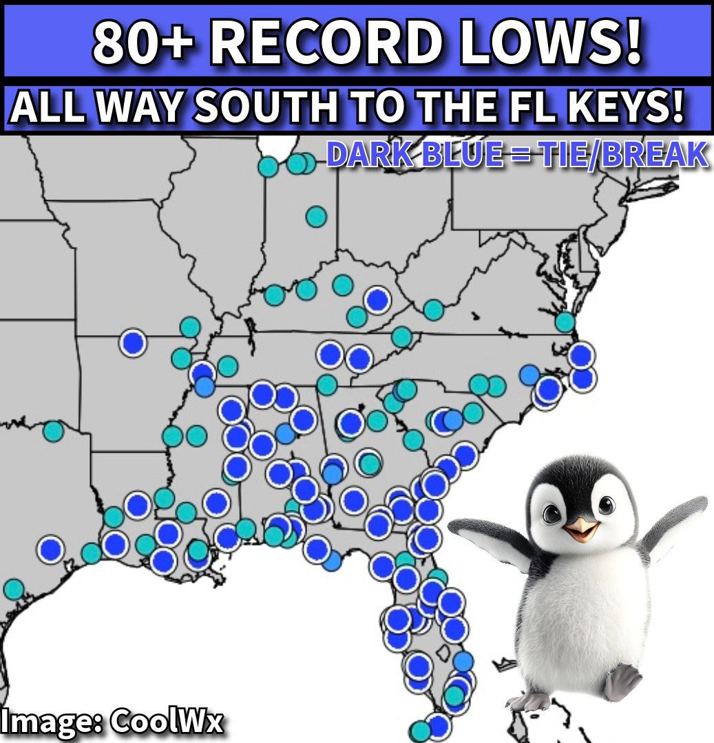
The big weather story this morning is the widespread record cold over the southeastern quarter of the nation as shown in the map above courtesy of CoolWx and Jeff Berardelli. More than 80 record lows were tied or broken this morning. A freeze occurred as far south as northern Florida, and south Florida saw morning lows in the 40s.
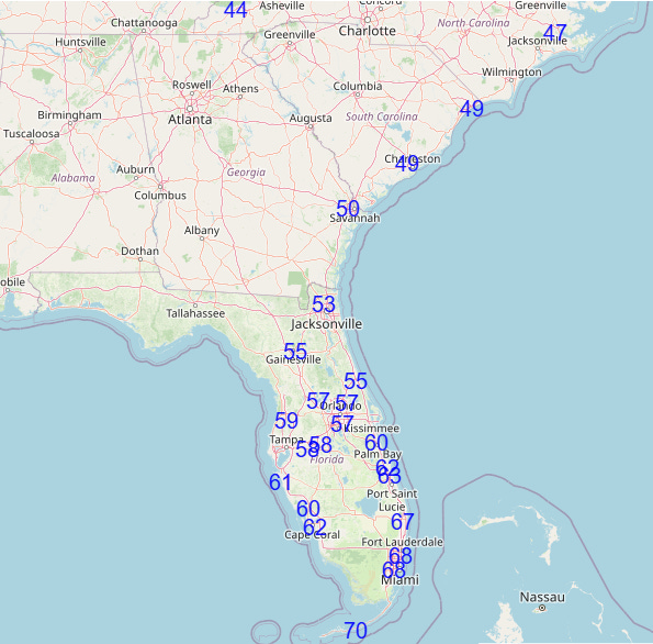
The record cold will continue this afternoon in Florida and along the Southeast coast as numerous record low maximum temperatures are anticipated, with highs in the 50s or colder as far south as the Interstate 4 corridor.
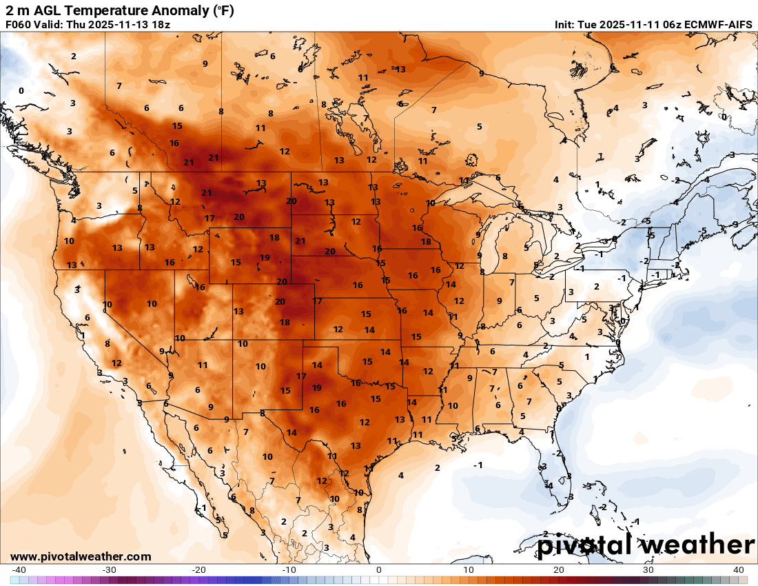
Today will be the last day for record cold though, as a dramatic shift toward above normal temperatures will quickly develop as unseasonably warm air over the western United States starts to rapidly shift east. By Thursday afternoon, much of the country will be at or above normal with regard to temperatures, with the central third of the country much above normal.
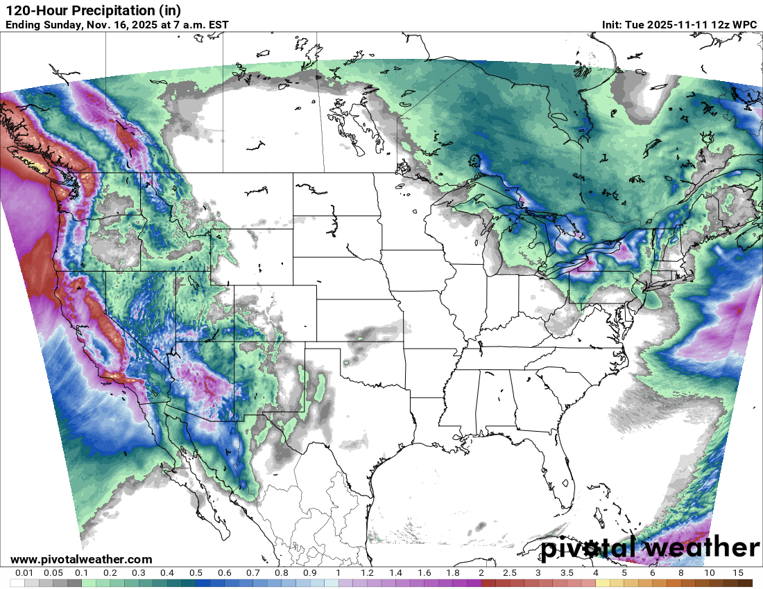
Heavy lake effect snow will continue for a couple of more days in the eastern Great Lakes, while a series of weather disturbances will bring heavy precipitation up and down the West Coast over the next several days. While some low probabilities of flooding issues will accompany these systems across California and the Southwest this week, overall this precipitation should be quite beneficial.
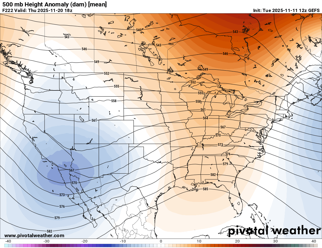
The weather pattern this week looks to be the start of an evolution to a more persistent pattern of an upper level trough in the western United States and a strong upper level ridge of high pressure in the East. This pattern would likely yield increased storminess across the central part of the country, and there are hints in some of the long range AI severe weather forecasts of increasing probabilities for severe thunderstorms in parts of the south central US starting next week.
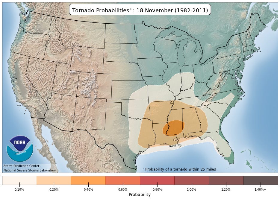
Mid to late November is a relative maximum in tornado activity for this part of the country, so this pattern shift will definitely something we will be keeping a close eye on in the coming days.
Note: The US weather community relies on the work of NOAA scientists who are exempt from the ongoing federal furlough due to the life-saving nature of their work. These federal employees are in their 42nd day of working without pay and without knowing when they will eventually receive pay. Last night, the Senate approved a bill which, if approved by the House and signed by the President, would end the shutdown and return federal employees to work, potentially as soon as late this week. Read more here.

Leave a comment