Wet and windy California the next couple of days, while unseasonable warmth builds for much of the country.
Nov 13, 2025
The big news this morning affecting the weather community is that the partial federal government shutdown is officially over. This means that so-called “non-essential” federal employees will return to work, and that the essential employees that have been working for 6 weeks without paychecks to maintain public safety will finally be getting paid for their efforts. As I talked about in a post during Hurricane Melissa, some essential NOAA employees have literally been undertaking potentially hazardous missions without pay in their roles as public servants, and I thank them and all of my former NOAA colleagues who have been working long and occasionally dangerous hours for weeks without knowing when they might be paid for their work.
Although the shutdown is over, most of the federal government, including NOAA and other federal agencies with important weather and water roles such as NASA, USGS, and FEMA, still do not have a budget for Fiscal Year (FY) 2026, which started on October 1. These agencies will be operating under a continuing resolution (CR) through January 30. This resolution is part of the bill passed by Congress and signed by President Trump last night to end the shutdown, and as I talked about on Monday, this particular continuing resolution seems even more restrictive than the “typical” CR in limiting how agencies can spend. Given that and the fact that the holidays are upcoming, I would expect federal science activities will be limited to the most basic activities and maintenance of operational capacity for the duration of this CR.
Obviously, the hope is that before January 30 we will have actual appropriations bills passed by Congress and signed by the President. At least for the main science agencies I refer to above — NOAA, NASA, USGS — there is a little bit of hope that this could happen. Senate Majority Leader John Thune (R-SD) intends to include the Commerce, Justice and Science appropriations bill that funds NOAA and NASA and the Interior and Environment appropriations bill that funds USGS into a new “minibus” funding bill that will be the next priority of the chamber.
However, as this Politico article lays out, there are still a lot of obstacles for this bill even in the Senate, as “all 100 senators would have to quickly assemble the (various appropriations) bills on the floor, likely followed by weeks of debate before a vote on passage.” Once that happens, the Senate appropriations leaders would have to work with their House counterparts to develop a compromise bill, and the article notes that right now there is a lot of distrust between the various factions of the legislature.
The obvious elephant in the room in all of this is that Congress as a bipartisan whole has a very different vision for what they want to see from the federal science agencies than the Trump Administration. The House and the Senate Appropriations Committees have already approved funding bills for NOAA and NASA, and they are much more about maintaining the status quo of these science agencies versus the major cuts and reorganization that the administration has proposed in its FY2026 budget.
As the Politico article discusses, all of this is further complicated by the fact that Office of Management and Budget Director Russell Vought has been shifting, freezing and canceling billions of dollars of spending Congress already approved — for example, the administration’s canceling the procurement of a new NOAA Phased Array Radar research instrument. The article notes that in the spending bills passed to this point that Congress has been more explicit in their wording about how the administration must spend the money.
Emergency management is a obviously a critical piece of the federal weather infrastructure in this country, and a FY2026 budget for FEMA is much farther away than what I have discussed for the science agencies. As of now, there is not even a draft Senate Homeland Security appropriations bill.
Needless to say, the coming months will be very consequential for the future of the federal part of the weather enterprise as all of this is navigated. Hopefully, the process will move forward in a way that will avoid us being right back in a partial shutdown situation come February 1.
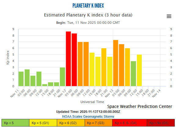
Following up on the space weather situation, the ongoing geomagnetic storm failed to ramp up last night to the same levels observed on Tuesday night, as can be seen in this graph of Planetary K-index. Hence, while aurora was seen in northern parts of the contiguous United States last evening, it was not visible nearly as far south as Tuesday night. While another peak in the storm is expected this evening, with level 3 (on a scale of 1 to 5) storm conditions returning, as of now it seems unlikely that aurora activity will become as active as that seen Tuesday night.
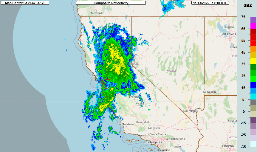
With regard to weather down here on the ground, the main focus this morning is in California, where heavy precipitation and strong gusty winds have been ongoing with a strong low pressure system offshore of northern California. Rainfall amounts of up to 3” have been reported along the coast, and some localized issues with flash flooding were reported around the Bay Area.
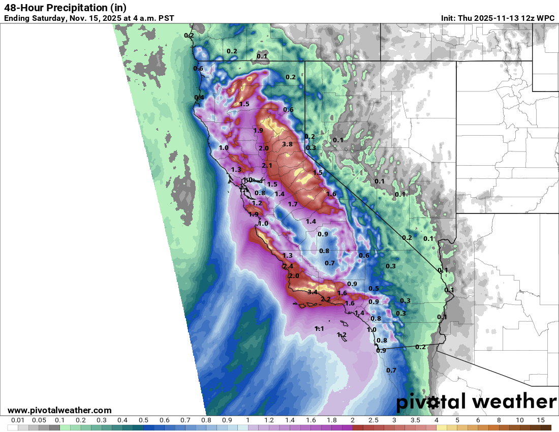
The heaviest precipitation today will be in the Sierra Nevada, where there is a slight (level 2 of 4) risk of flash flooding and winter storm warnings are in effect at higher elevations for heavy snowfall. The precipitation will shift farther south on Friday, with heavy rainfall expected in the mountainous areas north of Los Angeles.
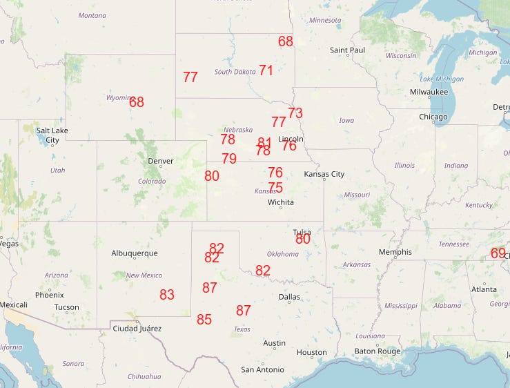
The other big weather story over the next few days will be the unseasonable warmth that will dominate much of the country, replacing the record cold that much of the Southeast saw the last couple of days (a few locations in Florida set record lows again Wednesday). Some record high temperatures were set out west on Wednesday, and numerous record warm temperatures — both maximums and minimums — are anticipated the next several days, with the peak coming on Friday (map of forecast record max temperatures above).
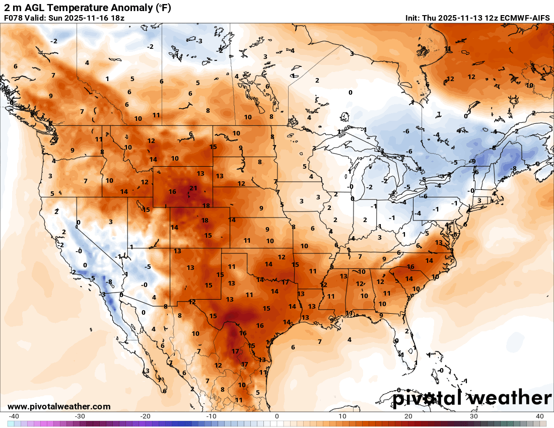
The Northeast will be the main holdout in this warm pattern, as a series of upper level weather disturbances and associated surface low pressure systems and cold fronts will keep some cooler air in place there into the upcoming weekend.
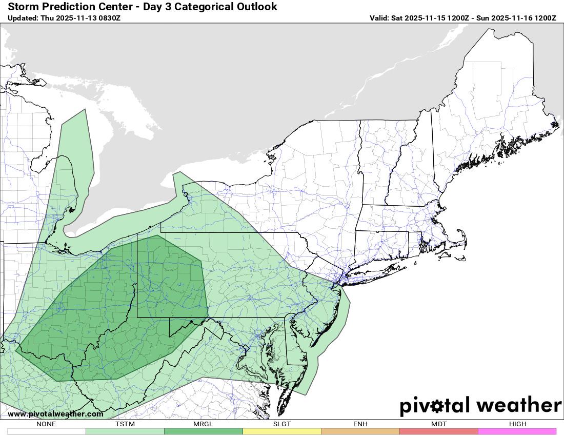
Of note with this weather pattern for the Northeast is that the Storm Prediction Center has added a marginal (level 1 of 5) risk for severe thunderstorms for parts of the eastern Great Lakes and upper Ohio Valley for Saturday, with the potential for a line of low-topped thunderstorms producing damaging winds along a cold front associated with a strong storm system moving through the region.
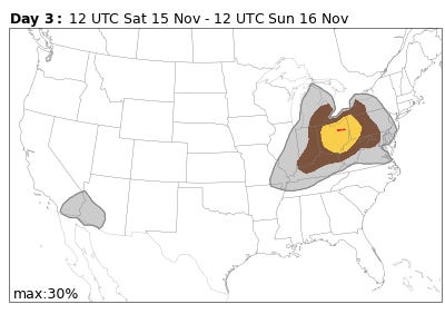
The new National Center for Atmospheric Research (NCAR) machine learning severe weather probability forecasts based on the European AI ensemble (shown above) have been quite bullish on this scenario for several days, and continue to show probabilities of up to 30 percent — equivalent to an enhanced risk from SPC — for Saturday. It will be interesting to see how this risk evolves over the next few days, and if this is case where the AI sniffed a situation out before the physics based models or a case where the AI was overaggressive.
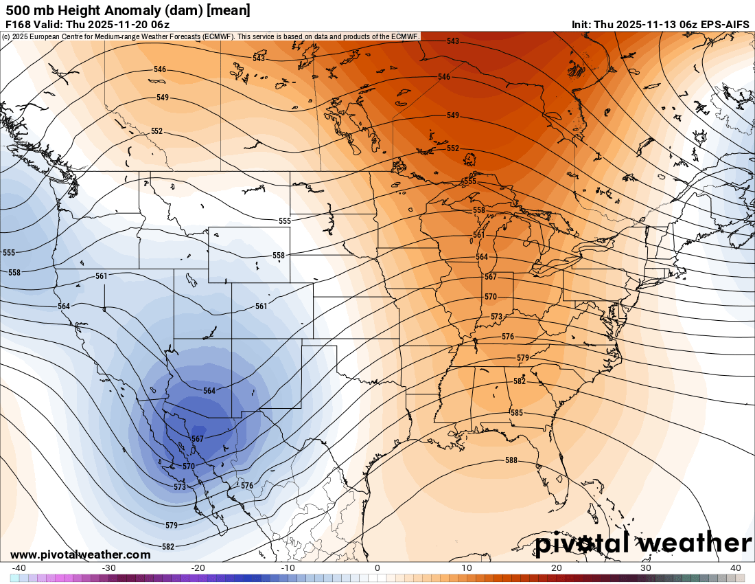
Meanwhile, the weather pattern continues to look more active and interesting with regard to severe thunderstorm potential for next week, especially across the south-central part of the country. While the models are in general agreement on the overall pattern of a persistent upper level trough of low pressure over the western United States and a downstream strong ridge of high pressure across the East as shown above, there is a lot of variance in how disturbances will move through that pattern, meaning there is corresponding uncertainty in timing and magnitude of potential risk areas.
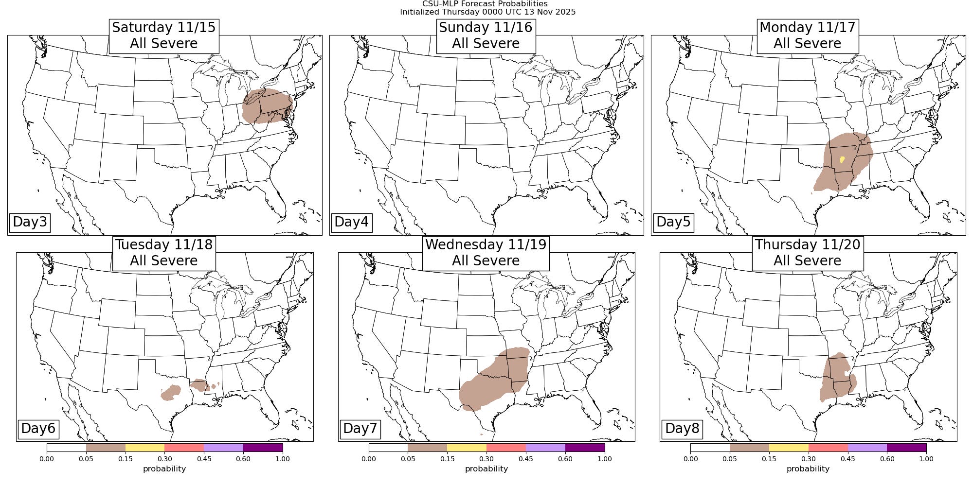
However, the various flavors of machine learning severe weather guidance are showing some areas of potential for next week (Colorado State University system shown above), and given the overall forecast pattern and that mid to late November is a relative climatological maximum in severe weather risk for this part of the country, we will be keeping a close eye on it.

Leave a comment