Also: Celebrating 50 years of meteorology at Jackson State University
Nov 14, 2025
Happy Friday! Before we get into the weekend’s weather stories, I want to acknowledge and congratulate the meteorology program at Jackson State University (JSU) which this week is celebrating its 50th anniversary. This meteorology program started in 1975 as a partnership between the university and NOAA, and was the first undergraduate meteorology program at a historically black college or university (HBCU).
In the 20 years I worked at the National Weather Service in Jackson, MS, I was lucky enough to play a role in the ongoing partnership between the JSU meteorology program and the National Weather Service. A number of JSU meteorology students came through our NWS office as student trainees and volunteers, and NWS meteorologists and professors and students in the program worked on many collaborative research-to-operations projects. In fact, one of my first peer reviewed journal articles, an analysis of a record snowfall event in central Mississippi in December 1997, was the result of a collaborative project between myself and Dr. Paul Croft, who was the JSU meteorology program coordinator at the time. Many meteorologists who would go onto successful careers and leadership roles within the meteorological community got their start in the program at JSU. This story from WJTV in Jackson (by JSU meteorology program graduate Ken South) gives more background on the JSU program.
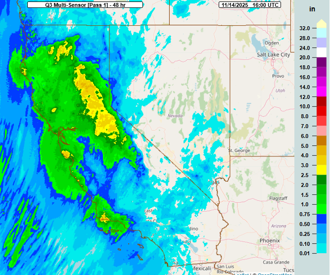
California continues to be the focus for active weather in the US today, as the upper level low pressure system that brought heavy precipitation (48 hour MRMS precip estimate shown above) to northern California, particularly the Sierra Nevada, shifts south.
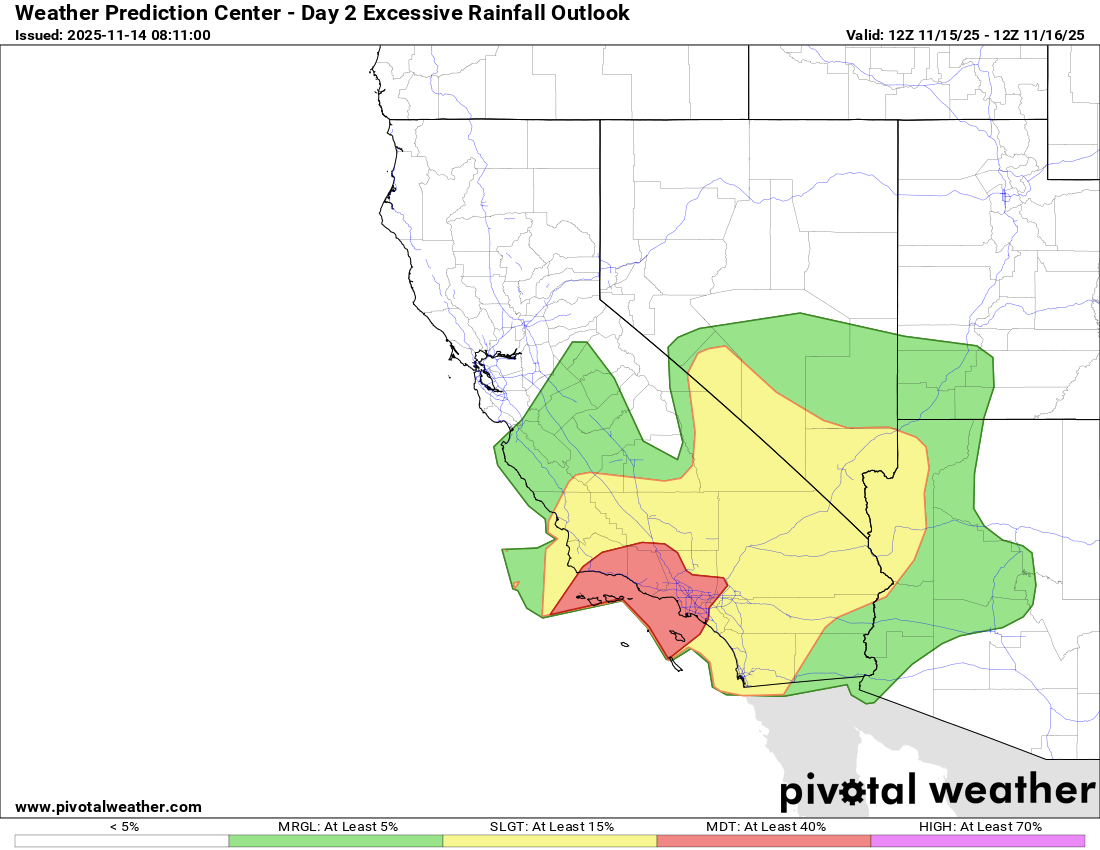
The threat for heavy rainfall and flash flooding in southern California has increased for tonight into Saturday, as a new strong upper level disturbance rotating around the upper low will push northeast into the region. The Weather Prediction Center now has a moderate (level 3 of 4) risk of excessive rainfall and flash flooding tonight into Saturday from the mountains north of Los Angeles into much of the metro area.
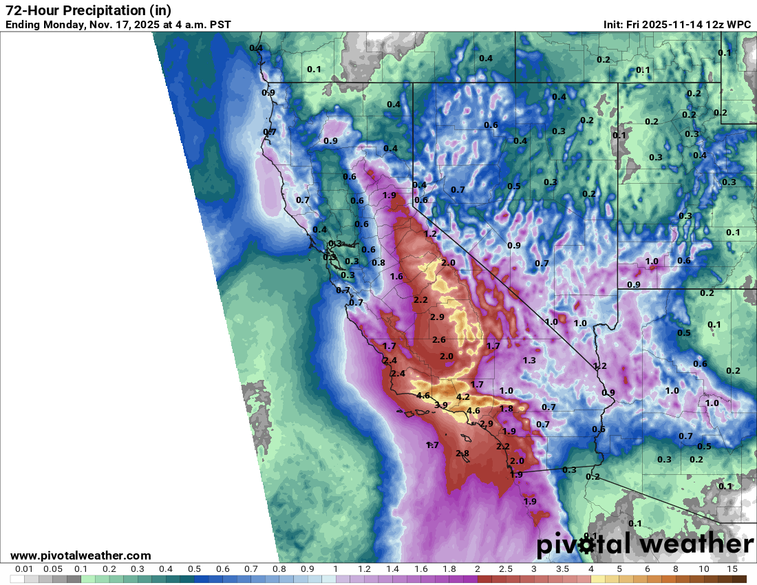
Rainfall totals of 6-10” are possible through the weekend across the terrain of southern California, particularly in the Los Angeles vicinity, with heavy precipitation also expected to extend northeast into the Sierra Nevada. Flash flood watches are now in effect for most of southern and central California, and winter storm warnings are in effect for the higher elevations of central California where heavy snow will continue.
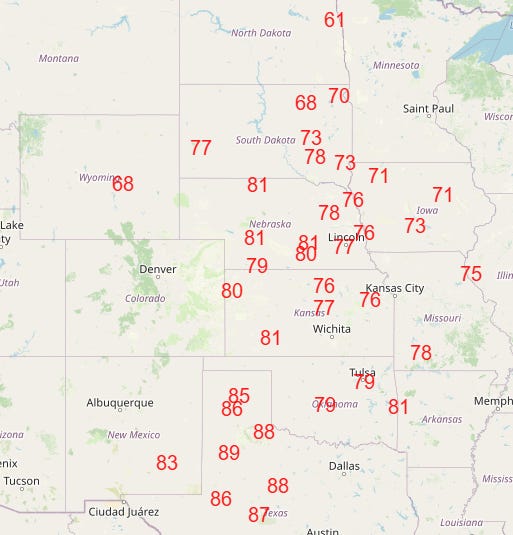
The other big weather story today is the widespread record warmth anticipated across the center of the country. After a number of record warm temperatures in the Rockies the last 24 hours, record high temperatures are expected this afternoon from the Canadian border to the Rio Grande (above). Unseasonable warmth will continue across the central and southeast parts of the country into early next week, but the record warmth will become more focused across the south central US.
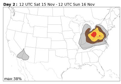
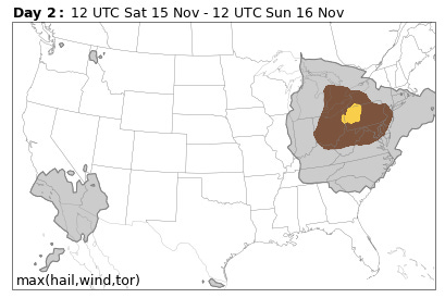
Meanwhile, we continue to watch an interesting forecast situation for the eastern Great Lakes and upper Ohio Valley for Saturday. The National Center for Atmospheric Research (NCAR) AI severe weather probability forecast based on the European AI model ensemble (top graphic) and Colorado State University AI forecast based on the US Global Ensemble Forecast (GEFS, bottom graphic) both show increased threats for severe weather in the region Saturday afternoon and evening. Given the overall forecast scenario, this would likely be in associated with a squall line along a cold front, with damaging straight line winds the main threat.
However, we are now within the time range of high resolution modeling, and even though these models show favorable parameters for an evolution like the AI forecasts are showing, none of these models develop the necessary squall line, and as a result they show little risk of severe weather. For example, the NCAR AI day 2 severe weather forecast based on the morning High Resolution Rapid Refresh model shows very limited severe weather risk over the region. As of now, the Storm Prediction Center has maintained a marginal (level 1 of 5) risk.
It is definitely a challenging forecast. As someone who forecasted in this region for several years, I certainly understand what the AI forecasts are seeing, as I have seen similar setups produce squall lines with a lot of wind damage. However, the upper level forcing for storms seems a bit misaligned with the cold front, which could result in the high resolution models being correct — but it would only take some small changes in the timing of the upper level system to yield a solution with greater severe potential. Needless to say, this will be an interesting situation to monitor.
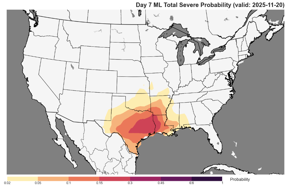
The overall pattern into next week continues to look potentially more active for severe weather. However, there are still significant differences in even the various ensemble forecasts for the basic atmospheric setup next week, and as a result the different AI severe weather probability systems have differing solutions for the magnitude and timing of the threat. They do suggest increased risk though (NSSL/SPC day 7 AI forecast based on the GEFS shown for illustration), and given that this is a climatologically more favored period for severe weather in this region, it is worth watching.

Leave a comment