Watching for a more active pattern for the central US next week
Nov 15, 2025
The main focus of active weather today will continue to be in southern California, where a strong upper level weather disturbance will move northeast across the region, bringing periods of heavy rainfall and scattered strong thunderstorms. The heaviest rainfall overnight was from just west of Los Angeles up through Santa Barbara, where radar estimates and gauge reports show amounts of up to 2.5”. Flash flood warnings and flood advisories are in effect in these areas this morning, including for the Palisades and Franklin burn scars. A number of reports of flash flooding, including a few mudslides, have been received by the NWS in this area.
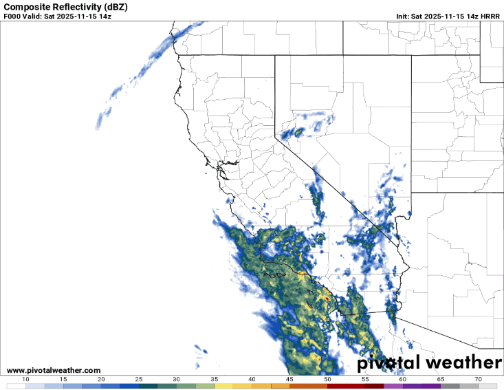
Expectations are that the peak of heavy rainfall and thunderstorm activity is still to come, particularly for the immediate Los Angeles area northeast into south central California, as well as for the San Diego area. This loop of forecast radar from the morning High Resolution Rapid Refresh model show increasing coverage of rain and some scattered thunderstorms across the LA basin and San Diego area this morning with peak activity this afternoon, followed by more scattered showers and storms into the evening.
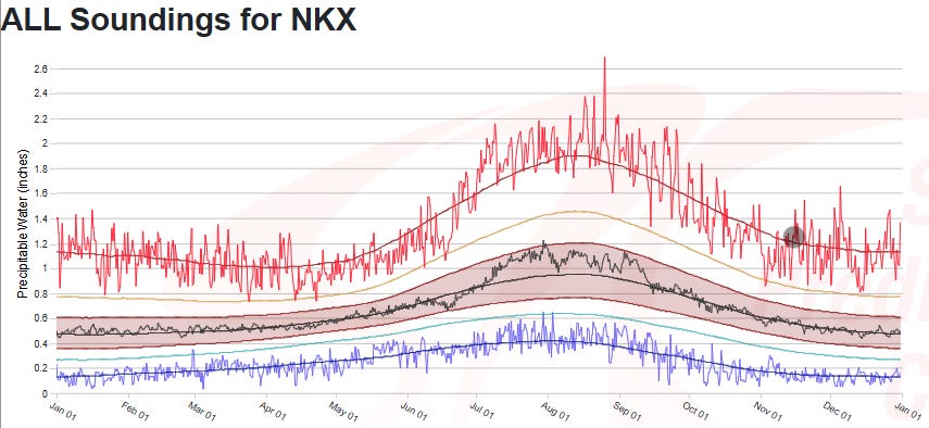
This weather system is pulling up tropical moisture from well to the south. The morning upper air balloon data from San Diego shows that precipitable water — the parameter that shows how much moisture is available in the atmosphere to form precipitation — is near the climatological max for the date. Rainfall rates of up to at least 1” per hour are possible in the most intense showers and storms today, and high resolution models suggest local amounts of up to 5” of additional rainfall, particularly in favorable terrain areas. This could produce significant flash flooding, particularly in urban areas, areas of terrain, and especially burn scar regions.
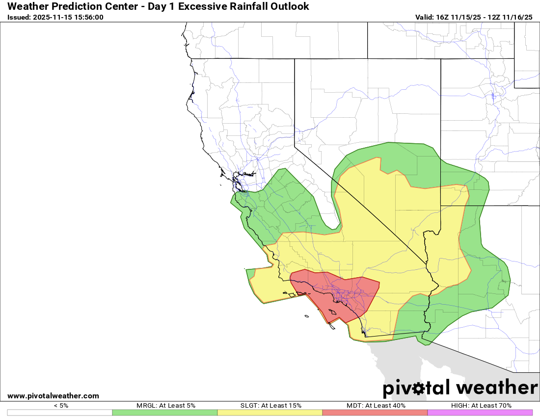
A moderate (level 3 of 4) risk of excessive rainfall and flash flooding is in place for the Los Angeles region, with a large slight (level 2 of 4) risk extending into southern Nevada and northwest Arizona. Flash flood watches are in effect for much of this region.
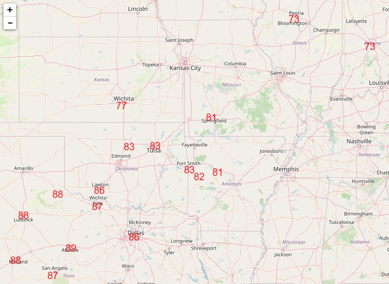
The other big story continues to the unseasonable, record warmth in the central United States. After dozens of record warm temperatures in the western and central US on Friday — including record highs at El Paso (83F), Oklahoma City (82F), Cheyenne (71F), Bismarck (73F), Wichita Falls (88F), Des Moines (74F) and Abilene (89F broke previous record by 5 degrees) — more record highs are anticipated across the central US today.
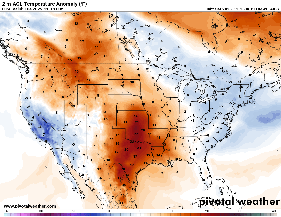
Unseasonable warmth will continue into early next week (Monday afternoon surface temperature anomaly from European AI model shown above), with more record warm temperatures anticipated particularly across the south central US. Unusually warm low temperatures are anticipated across the region, with forecast lows in the 70s in south Texas. These are values more typical of the summer, as normal low temperatures in south Texas at this time of year are in the 50s.
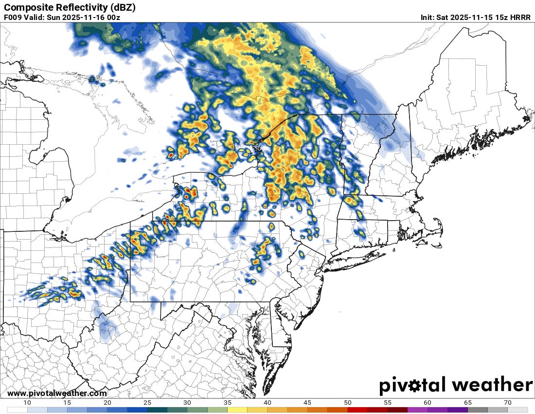
The Monday temperature anomaly map shows some cooler air in the East, and we continue to watch for the potential for some thunderstorm activity with gusty winds across the eastern Great Lakes and upper Ohio Valley regions this afternoon and evening as the cold front ushering in that cooler air moves across the region. Morning high resolution models are now showing a couple of bands of showers and a few thunderstorms moving across the region (latest High Resolution Rapid Refresh model forecast radar for 8 pm ET above) that could help mix down stronger wind gusts. These storms still do not look well organized into the type of squall line that could produce more significant and widespread winds, and right now the Storm Prediction Center continues to just have a marginal (level 1 of 5) risk of severe storms in place.
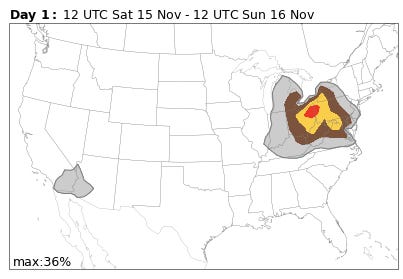
The AI severe weather forecasts based on the global European (shown above) and US models continue to be much more bullish on severe weather potential in this region today. My gut instinct is that these models are overdone due to not being able to discern the lack of smaller scale thunderstorm organization needed to produce a more significant severe weather event in this sort of weather setup — but obviously we will keep an eye on it today.
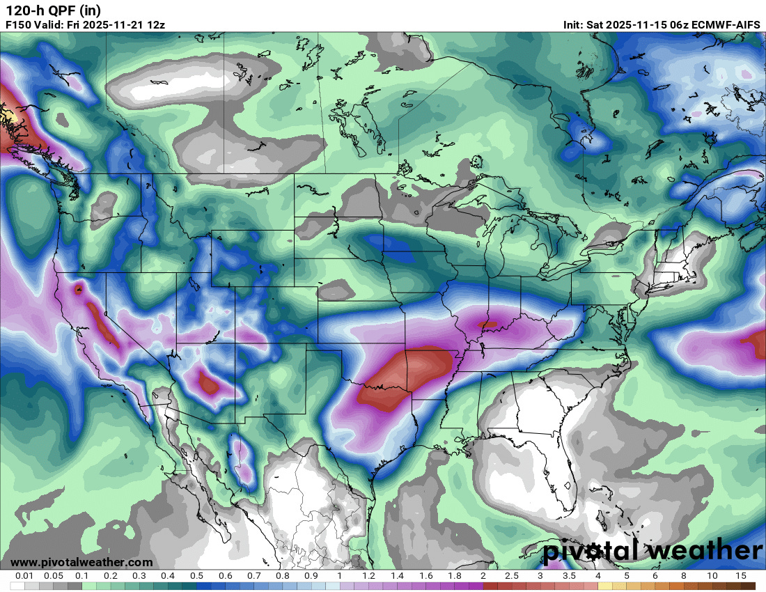
The weather pattern continues to look more active for the central part of the country next week. There still looks to be some increased risk for severe thunderstorms in parts of the central and south central US, but as I discussed yesterday, there are still a lot model differences as far as timing and magnitude of the potential risk. At a minimum, the pattern should bring increased rain and thunderstorm activity to an area that has been quite dry in recent weeks. More heavy precipitation is also anticipated early next week across California and the Southwest, which could lead to additional flooding concerns.

Leave a comment