Wet weather over the West gradually shifts into the center of the country this week, while Sunday brings an unusual critical fire danger risk to the Mid-Atlantic.
Nov 16, 2025
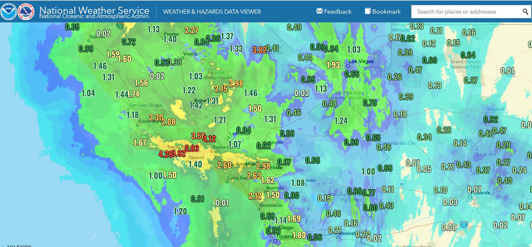
Starting off this morning with a quick recap of the heavy rain and flooding in southern California. Saturday was the peak of this first period of significant rainfall (48 hour observed and radar estimated totals above) for the region, with heavy rains causing flooding and mudslides as summarized in this Los Angeles Times article. Luckily, though, Saturday’s rainfall appears to have verified on the lower end of model projections, so while there were certainly issues, the observed amounts combined with mitigation efforts taken in advance of the event appear to have prevented much in the way of serious impacts. The rainfall of course is also very beneficial as far as reducing fire danger — last year southern California saw an extremely dry start to rainy season which helped fuel the devastating January wildfires.
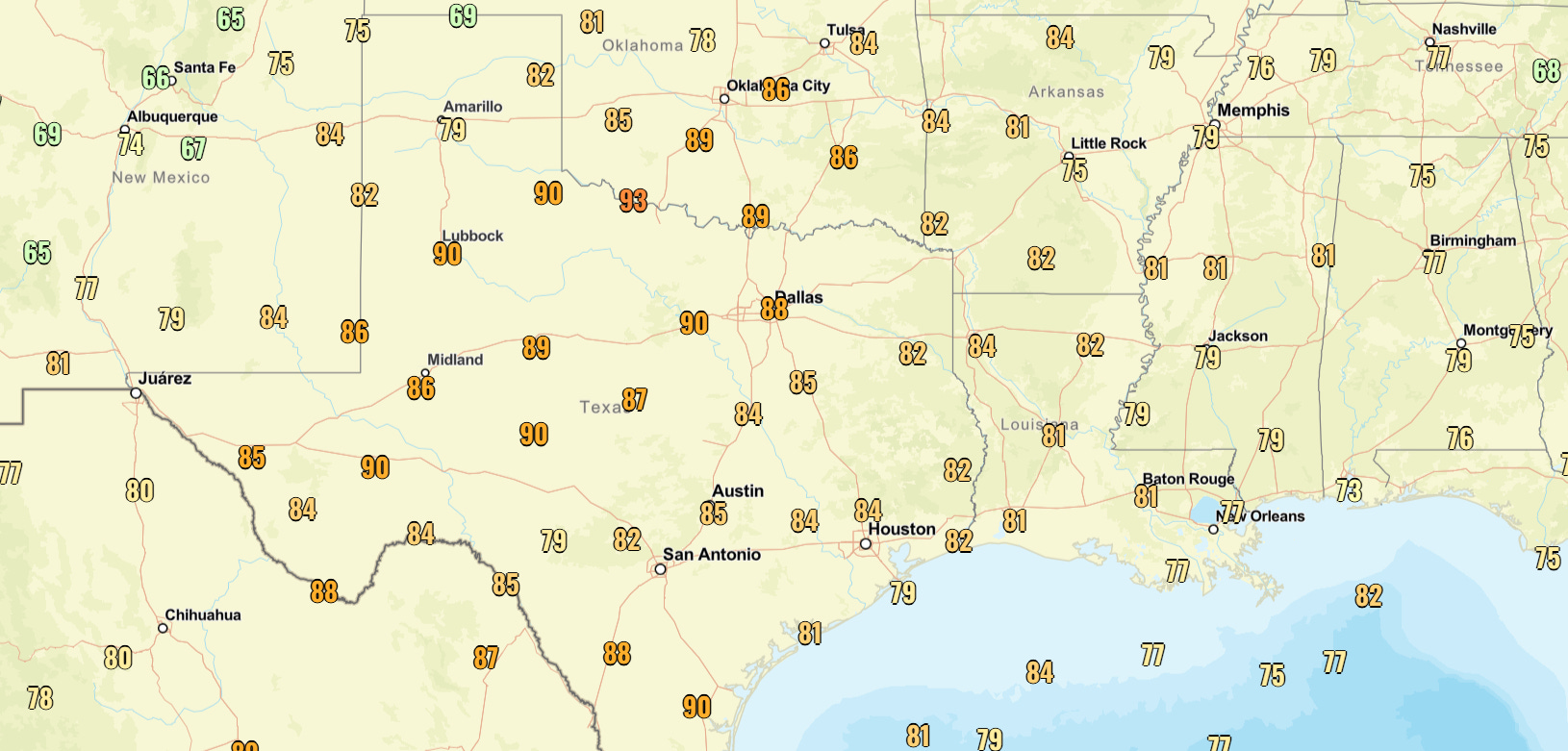
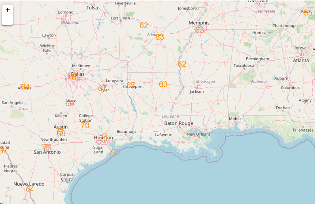
The other major weather story Saturday was the extraordinary mid-November warmth — really, heat — across the south central United States. High temperatures in the 80s and even lower 90s were widespread across the region. A number of locations in northwest Texas and southern Oklahoma set all-time record high temperatures for the month of November. These included Lawton with 91F and Lubbock with 90F; these locations broke their records for latest 90F in the year by 7 and 6 days, respectively.
While the unseasonable and record breaking cold over the Southeast got a lot of media attention earlier this week, this stretch of warmth over the central United States is actually much more unusual climatologically. Breaking November record high temperatures in the middle of the month is very unusual, since as an autumn transition month record warm temperatures are usually established early in the month. Warmth has also been a persistent trend for much of the first half of the month. As an example, Denver has experienced its 5th warmest first half of November on record, running 7.5F above normal. Meteorologist Chris Bianchi posted on BlueSky this morning that 2025 is now in the top 5 for latest first snowfalls on record for Denver, and will reach the top 3 later this week.
In doing research for today’s post for my central Florida focused weekly weather newsletter Fairy Dust Forecast, I discovered that this past Tuesday, the peak day of the record cold in the Southeast, was actually the coldest November day in the 21st century in Orlando, with a daily mean temperature of 47F. While it seems pretty impressive to have that sort of a record set so early in November, when you dig deeper, you find that even though it was the coldest November temperature of the last 25 years, it was only tied for the 24th coldest November daily mean temperature on record. In fact, only one other 21st century day is even in the top 75 coldest November days on record for Orlando (records back to 1892).
Obviously, if these cold temperatures were distributed evenly over the entirety of the Orlando climate record, we would expect to see a lot more than two days this century in this list of coldest November days. This is yet another demonstration of how much rarer prolonged cold outbreaks have become in recent years — and helps explain why this brief record cold shot was so newsworthy.
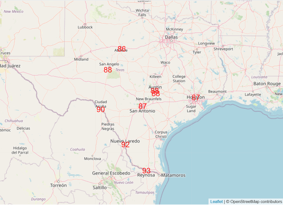
The record warmth is not going anywhere anytime soon. Today, record highs will be more confined to Texas, but there will still be a number of locations reaching the upper 80s and lower 90s (forecast records shown above).
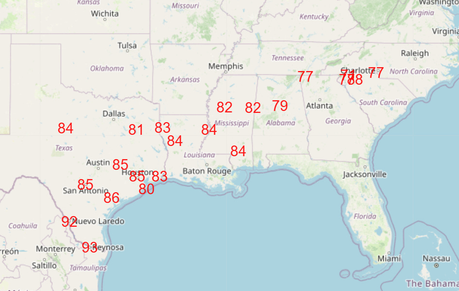
The record warmth will continue and gradually expand, and by Thursday record highs are expected across much of Texas and the Southeast (shown above).
With unusual warmth and moisture, record warm minimums will also be widespread, with Wednesday (shown above) looking to the peak extent of these. Low temperatures in the 70s in south Texas are more typical of summer than the last half of November, when normal lows in this region are mainly in the 50s.
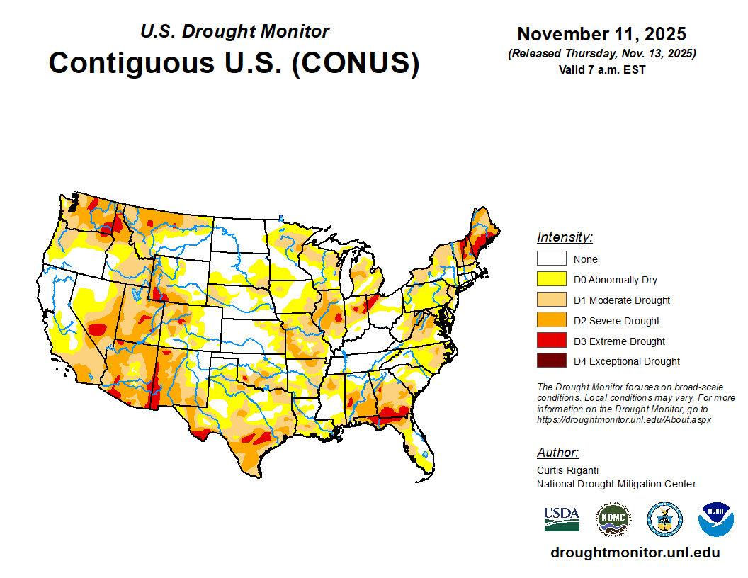
Along with the unseasonable warmth, drought has also become an increasing issue in recent weeks for large parts of the country.
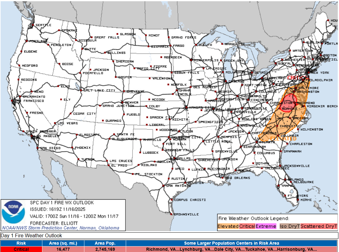
In the wake of a cold front, gusty and dry northwest winds will create a rather unusual critical fire danger day today in the Mid-Atlantic, one of the areas that is suffering from moderate to severe drought. Red flag warnings are in effect for most of Virginia and northern North Carolina. Gusty northwest winds are also anticipated farther north with wind advisories in effect for much of Pennsylvania and southern New York. Heavy lake effect snow showers are also anticipated downwind of lakes Erie and Ontario.
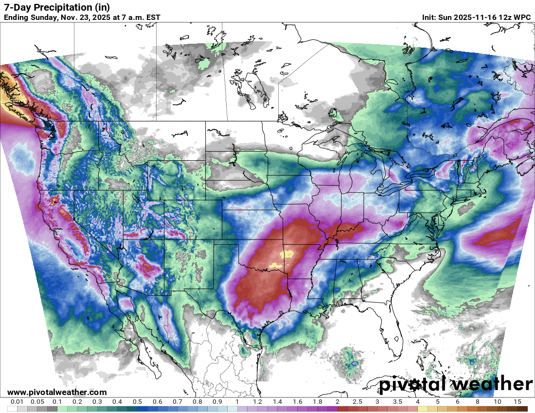
With regards to precipitation this week, a new upper level low pressure system will bring additional heavy precipitation to the West the next few days. By later in the week, the active pattern that we have been talking about for the central United States will begin to evolve, with waves of showers and thunderstorms bringing some needed rainfall to the region. Some risks for severe weather and flash flooding will likely evolve, so we will be keeping an eye on that.
Speaking of severe weather and looking back at our discussion the last couple of days about the possibly overzealous AI severe weather forecasts based on the global models, while there were a handful of severe thunderstorm wind damage reports across West Virginia last evening, the overall severe weather risk did remain more muted, along the lines of the Storm Prediction Center’s forecast and AI forecasts based on the high resolution models.

Leave a comment