Additional heavy rainfall is forecast to push some rivers well above all-time record levels
Dec 10, 2025
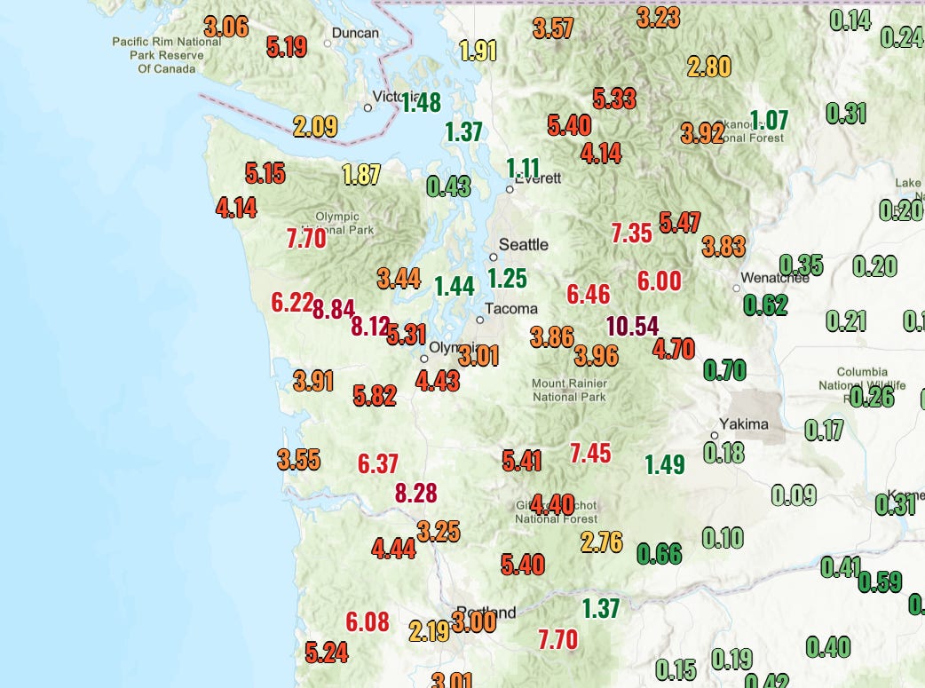
There are lots of weather and emergency management related news stories this morning, but I will defer talking about those to focus this post on the ongoing significant and potentially catastrophic flooding in the Pacific Northwest. Widespread moderate to heavy rain is falling over the Pacific Northwest this morning, and the 48 hour rainfall total map above shows that higher elevations of western Washington and northwest Oregon have seen widespread 5 to 10 inch rainfall totals.
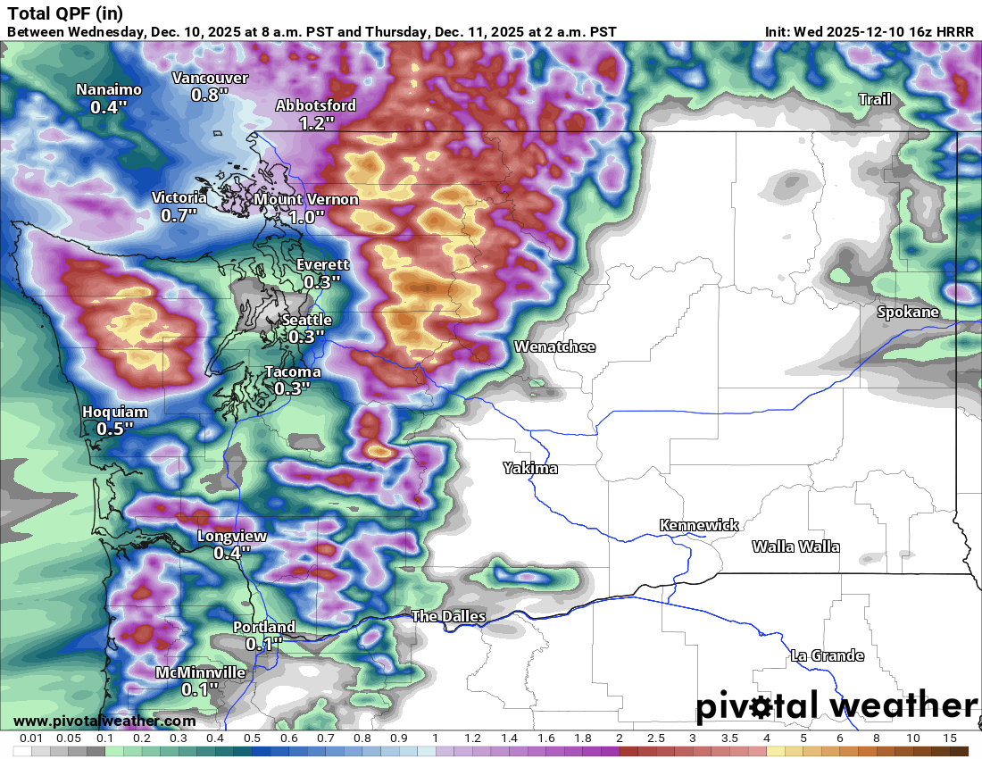
As the final weather system in this current wet pattern moves through, additional heavy rainfall is expected through the day today, particularly across northwestern Washington state. NWS Seattle noted that forecast rainfall totals with this wave of heavy rainfall have increased, and the most recent High Resolution Rapid Refresh model rainfall forecast (above) shows widespread 4” rainfall totals in the higher terrain west and east of Seattle, with particularly heavy amounts in the Cascades to the east.
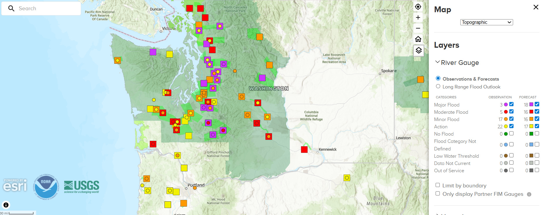
The rainfall that has already occurred has pushed a number of rivers in the region into flood, with a few locations already in major flood. The snow levels with these weather systems have been unusually high, meaning that even at higher elevations where snow would normally be occurring, heavy rain is falling instead and running off into streams and rivers. With the additional heavy rainfall forecast in the Cascades east and northeast of Seattle, the rivers flowing west from those mountains into Puget Sound are of particular concern for seeing significant additional rises today that could result in record — and in some cases potentially catastrophic — flood levels
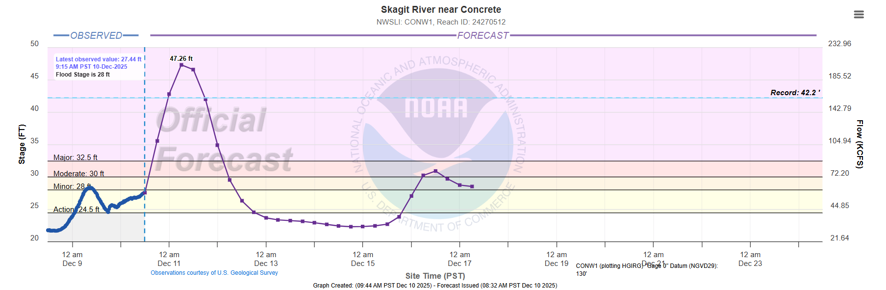
The forecast for the Skagit River is almost hard to believe, with the gages at Concrete (shown above) and Mount Vernon forecast to crest early on Thursday at about 5 feet above their previous records. Both of these gage sites have periods of record of more than 100 years, and exceeding the record levels by 5 feet would be almost incomprehensible to me.
Needless to say, this would result in catastrophic impacts along the river, given that the forecast impacts for a 40’ stage as taken from the NOAA hydrology website.
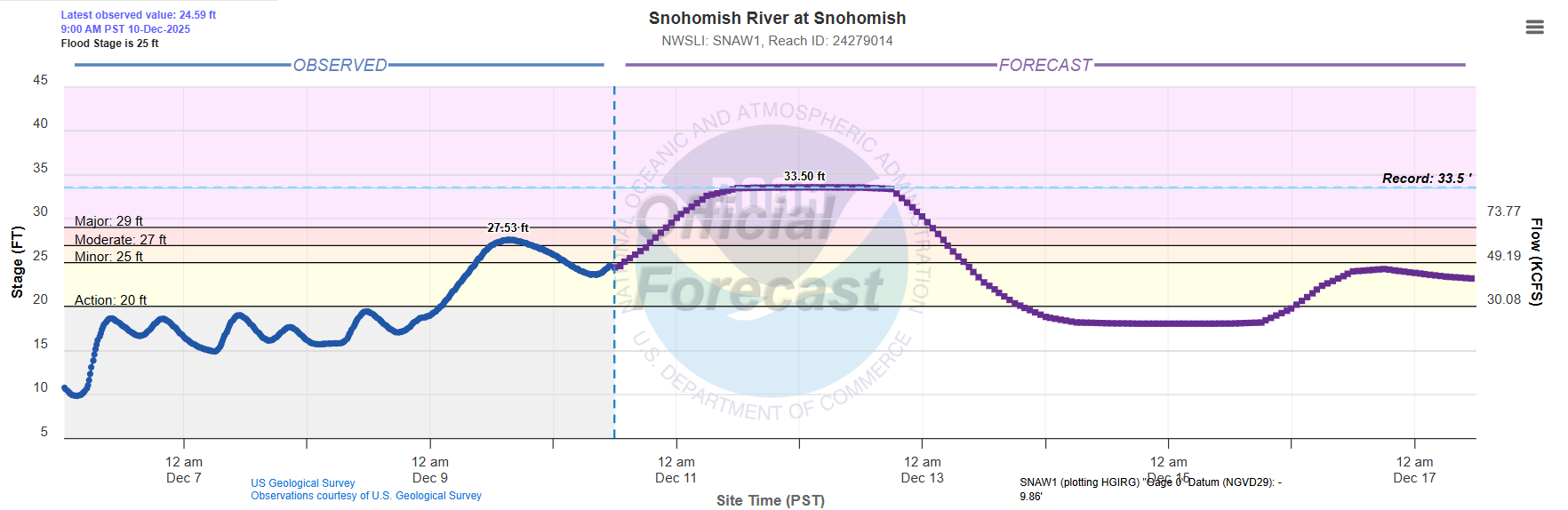
The Snohomish is another river in this region of serious concern, as it is forecast to crest near the all-time record with major impacts anticipated.
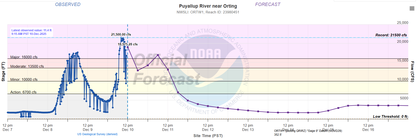
Meanwhile, the Puyallup River south of Seattle looks to have peaked earlier this morning at or near a record level.
In addition to the river flooding, the potential for landslides is also high today in the region, along with possible debris flows in burn scar areas from prior wildfires.
As we have been discussing, after today the weather pattern looks to trend drier (although still with high precipitation chances) for the Northwest. Unfortunately, longer range models suggest the return of heavier precipitation along with unusual warmth and high snow levels by sometime this weekend into at least the first part of next week.
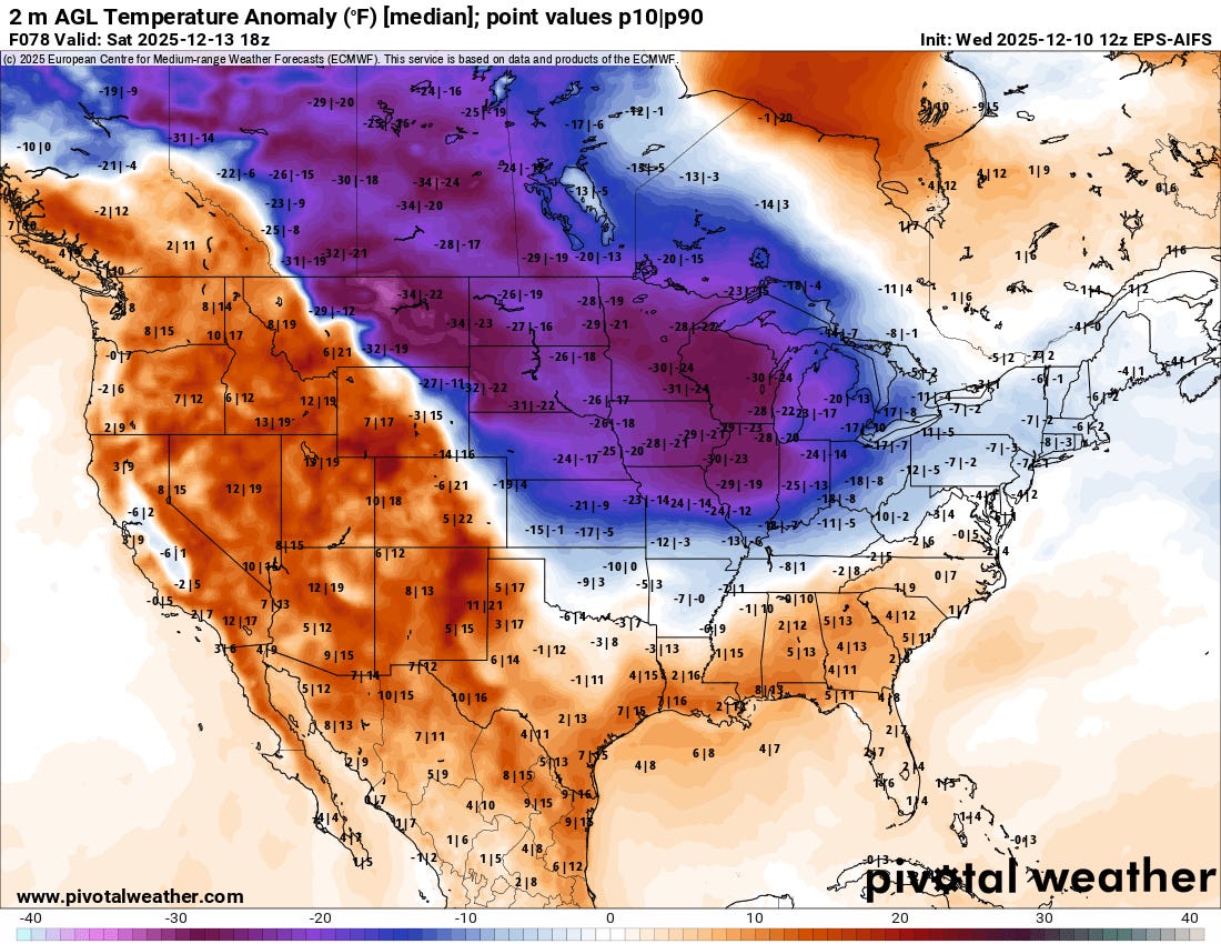
Finally, just a quick note that while unseasonable and at times record warmth will continue in much of the West (except the Central Valley of California, see this post from SF Chronicle meteorologist Anthony Edwards), another shot of arctic air is expected into the Midwest and parts of the Northeast by this weekend, with temperatures as much as 30 degrees below normal (forecast temperature anomalies for midday Saturday from European AI ensemble above). Some record cold temperatures will again be possible, especially in the Ohio Valley.
I will be continuing to monitor the flooding situation in the Northwest, and will provide updates via BlueSky and Substack. I am also tentatively planning a video update on the situation this evening – as a reminder paid subscribers can participate in these videos as they happen and ask questions, I will send out a specific time and information to participate later today. If interested in a subscription, more info on the ongoing holiday special below.

Leave a comment