Some Deep South snow on Sunday may set the stage for more southern winter weather later this week
Jan 19, 2026
Happy Monday! After a week of focused on Congress and the process surrounding the federal budget, this week is going to need a lot more discussion of actual weather, as we are looking at the potential for a very cold and active winter weather pattern east of the Rockies later this week and into early next week. Before we dive into the weather, though, I did want to mention that as of now, the President has not yet signed H.R. 6938, the federal funding bill the Senate passed last Thursday. I am not aware of any issues or concerns that it will not be signed — just clarifying that it is not yet officially signed into law.
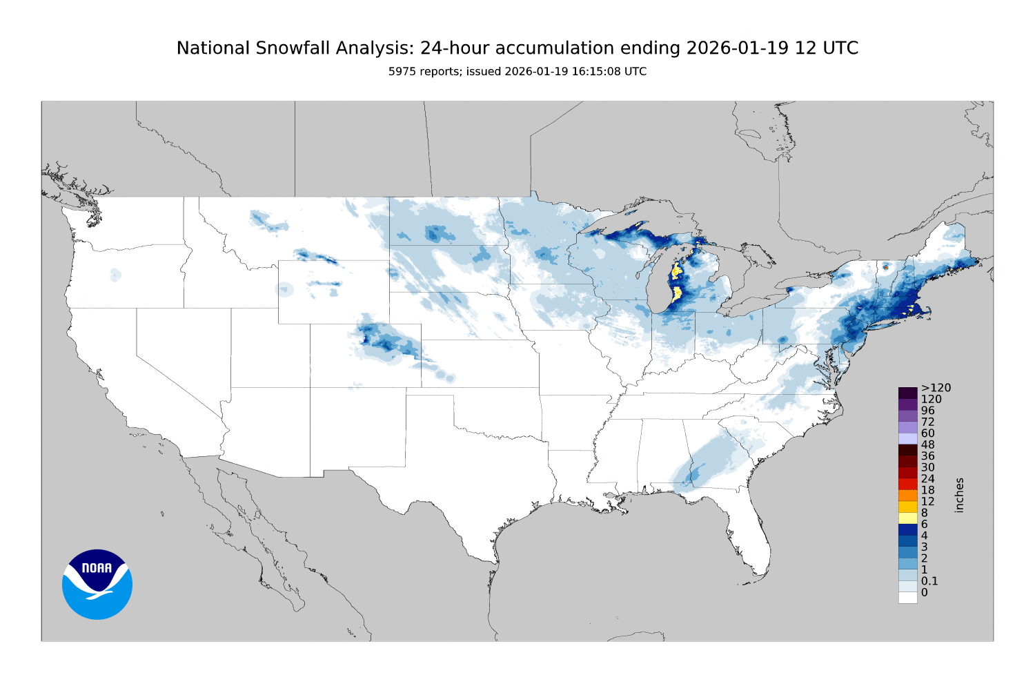
A quick recap of yesterday’s winter weather, there was some periods of snow across parts of the Florida Panhandle into the Carolinas Sunday morning, with some light accumulations from northwest of Tallahassee across central Georgia. Spots in southwest Georgia picked up 2”. Once the sun came out yesterday afternoon, though, that snow melted pretty quickly as is often the case in the South. As expected, the more substantial snowfall Sunday was from the Delmarva into southern New England and Downeast Maine. Heavy lake effect snow of up to 10” fell downstream of Lake Michigan across the western Lower Peninsula.
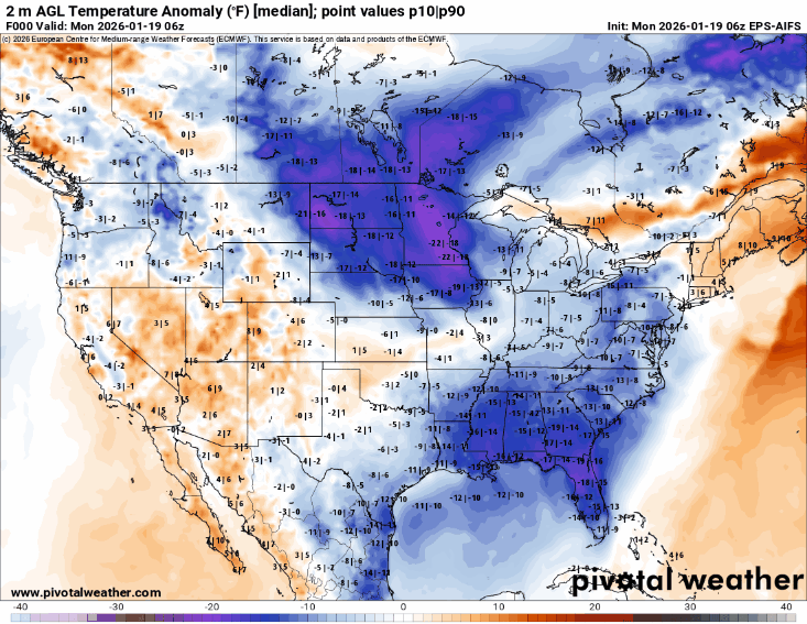
At a high level, the overall weather pattern that we have seen the last number of days looks to stay pretty locked in for at least the next 7-10 days, i.e., a large upper level ridge of high pressure centered along the West Coast an eastern Pacific dominating the pattern, with a downstream upper level of trough of low pressure across the eastern half of the country. This will allow continued pieces of cold Arctic air to drop south into the region east of the Rockies with brief warm ups ahead of each cold shot — this is shown well in the animation of surface temperature anomalies for the next 8 days from the AI European ensemble model shown above.
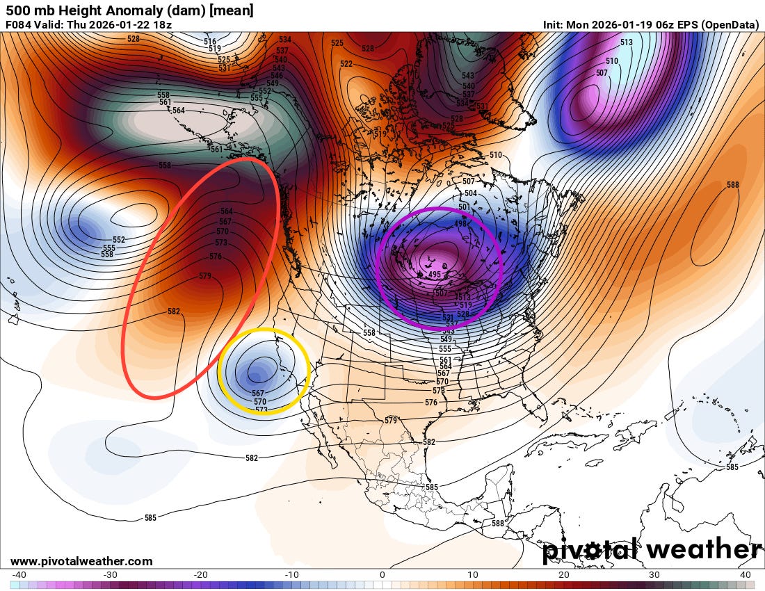
Some subtle changes to the pattern this week though will provide a path for a period of particularly cold weather for the central and eastern US this weekend, along with the potential for a significant winter storm. The upper level weather pattern will experience “retrogression” this week, meaning the main features will all shift west. This can be seen in the above 500 millibar (~18K ft) weather chart from the European ensemble model valid midday Thursday above. The upper level ridge (red ellipse) will shift farther to the west and be centered into the Gulf of Alaska, which will allow the polar vortex (purple circle) to drop south into south central Canada. All of this will enable a plunge of Arctic air through the central part of the nation all the way to the Gulf Coast by this weekend (seen in the deep purples dropping south in the temperature animation this weekend).
Meanwhile, an upper level low pressure system (yellow circle) that will break off over the Pacific southwest of California will be forced northeast by all of these changes, and will become a driver for a winter storm that will interact with this cold air to provide a large swath of wintry precipitation into early next week.

This forecast change of the weather pattern is a rather complex evolution, and the models notoriously struggle with retrogressive patterns. Hence, there is still a lot of uncertainty in how this will all play out. For now, the NWS Weather Prediction Center (WPC) probabilistic winter storm severity index (WSSI) for next weekend shown above looks to provide a good first guess of potential locations that could be impacted by wintry precipitation. Areas along the southern periphery will be more likely to experience freezing rain and/or sleet, while areas farther north will have higher chances for snow.
This setup could result in heavier accumulations of wintry precipitation in some of these areas depending on the ultimate evolution of the main storm system, so people across the southern half of the country should be keeping a close eye on forecasts. Obviously, I will be updating on things as we go through the week.

Leave a comment