Still lots of details to resolve, but serious impacts look increasingly unavoidable
Jan 20, 2026
When I started this Substack nearly a year ago, my stated goal was to provide weather information with (hopefully) helpful scientific background and explanation and without unwarranted hype, i.e., “hype for clicks.” However, I also said that my intent will be to loudly sound the alarm on weather events when it is warranted — and it is looking increasingly like the winter weather pattern that is setting up for much of the country this weekend into early next week warrants that sort of hype.
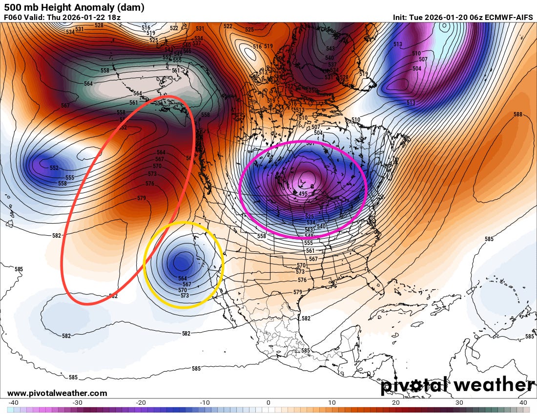
The overall weather pattern driving this winter weather situation has not changed since yesterday. An intense upper level high pressure ridge (red ellipse) will retrograde to be aligned from the Gulf of Alaska south, forcing an intense polar vortex (purple ellipse) south into the upper Midwest and south central Canada. This will drive a very strong area of surface Arctic high pressure south into the United States, delivering unusually cold air all the way to the Gulf Coast.
Meanwhile, an upper level low pressure center off of southern California will be sliding east and “undercutting” this pattern, resulting in the development of a low pressure system over the Gulf that will move east-northeast toward the southwest Atlantic. This system will be tapping into unusually high levels of subtropical and Gulf moisture to produce widespread heavy precipitation across the southern half of the country. Obviously, with cold air funneling south, significant wintry precipitation in the form of snow, sleet and freezing rain will be occurring where temperatures get cold enough to support those wintry precipitation types.
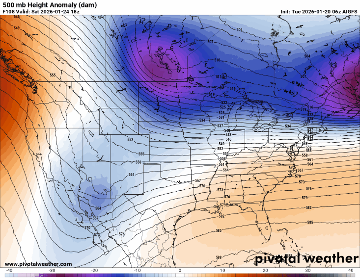
While this overall upper level weather pattern is supported by all the models, there remain a lot of differences in the details which will have huge implications on how much and what type of precipitation will fall in any given area, as well as how cold temperatures will get. This animation shows the individual 500 millibar (~18K feet AGL) forecasts for midday Saturday from seven operational deterministic models (US and European AI global models, US Global Forecast System, European model, Canadian model, German model, and the UK model). I obviously do not expect non-meteorologists to understand the details of this, but rather I am just showing it to demonstrate how much difference there is between the models — particularly with the location and strength of the undercutting system in the Southwest and the next piece of the polar vortex dropping south into the northern US. These differences will have major ramifications on the details of the forecast for this weekend.
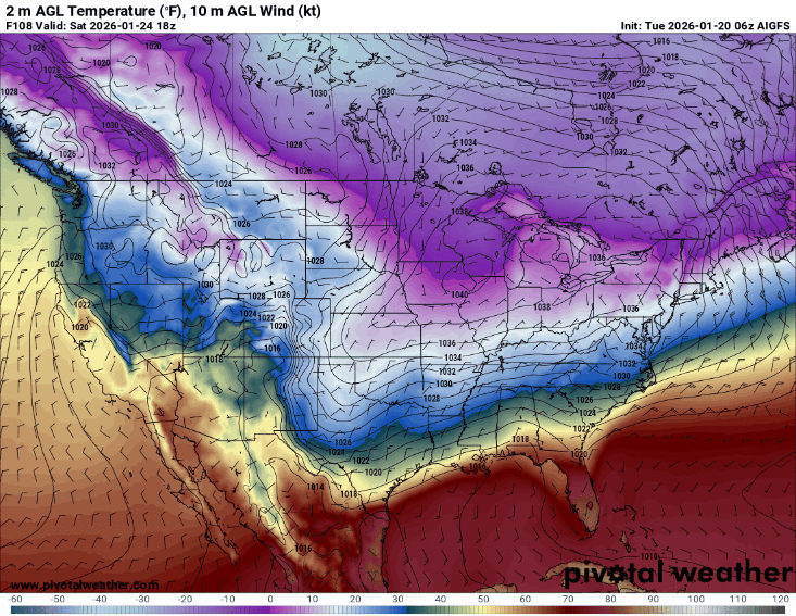
One of the main ways in which these model differences will impact sensible weather is with surface temperatures. This animation is the same type of loop as the one above, only this is for surface temperatures at midday Saturday. Again, without getting into the details, you can pretty clearly see the major differences in the intensity and location of the Arctic air — which will significantly affect precipitation types across the southern US.
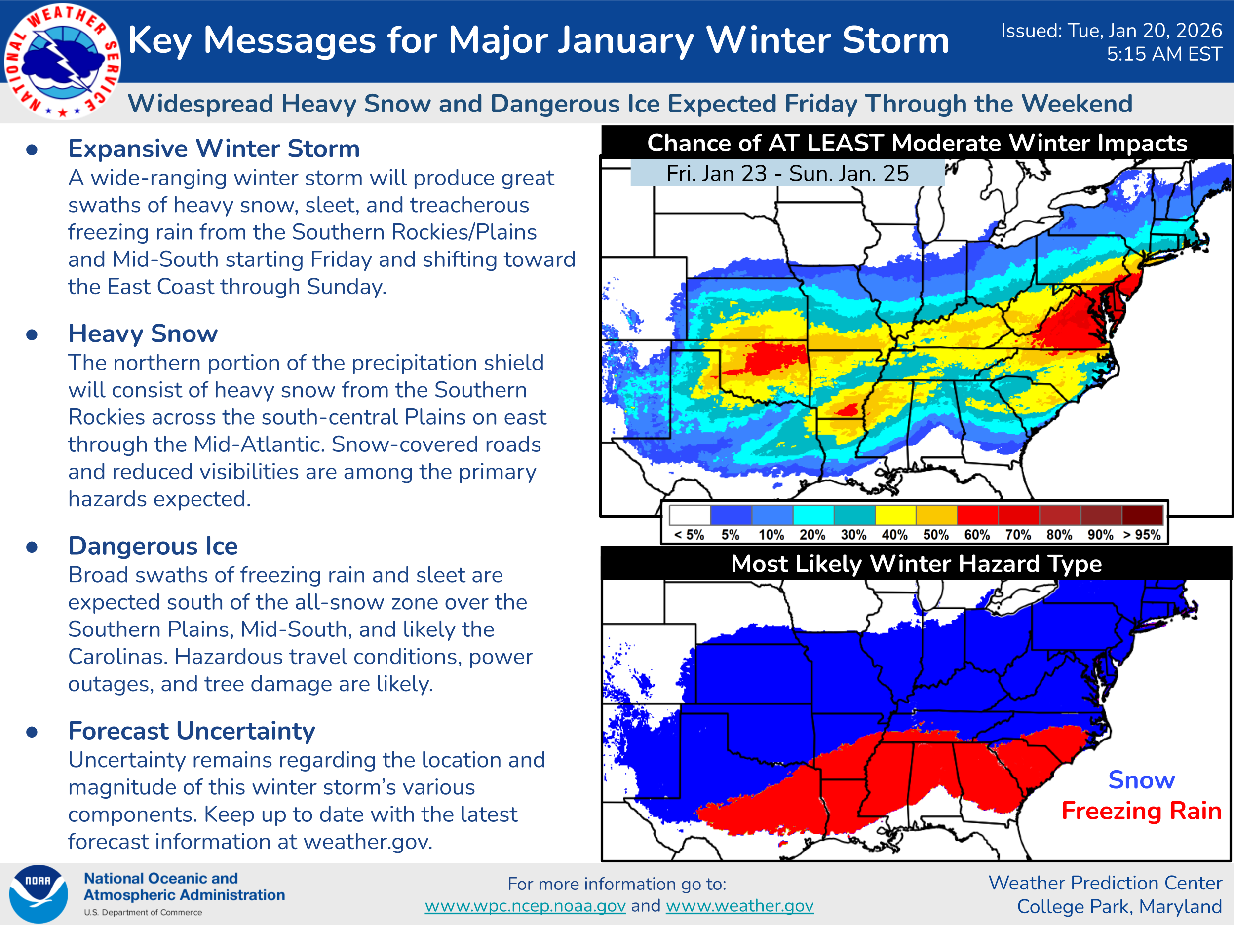
This key messages graphic from the NWS Weather Prediction Center provides an excellent overview of the potential impacts as things stand right now. The graphic in the upper right is derived from WPC’s probabilistic Winter Storm Severity Index (WSSI), and shows the likelihood of at least moderate impacts, i.e., disruptions to normal daily life due to winter weather. (Note that some significant accumulations of sleet are also likely, particularly in the transition region between snow and freezing rain on the winter hazard map above.)
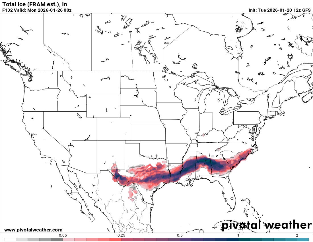
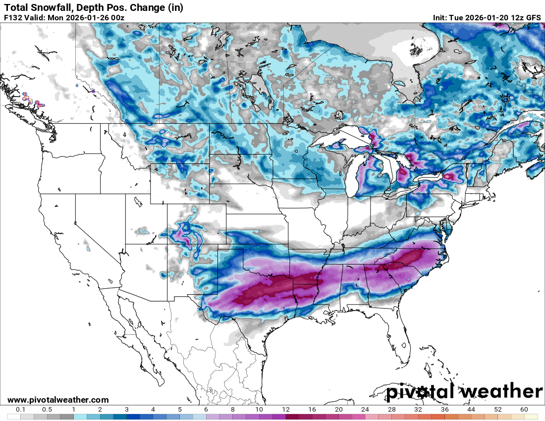
I think it is important to emphasize that while the uncertainty in the details remain, the overall setup and the consensus of the models suggest that there will be swaths of very heavy snow and ice with this system. For illustrative purposes, above are the forecasts of freezing rain and snow accumulation through Sunday evening from this morning’s US Global Forecast System. While other models show different locations and maximum amounts, all the models pretty much show that there will be swaths of 1 foot or greater snowfall with extremely heavy glaze accumulations south of the heavy snow. Hence, while we cannot yet pinpoint exactly what areas will be most impacted, there are high probabilities that major impacts — including treacherous to impossible travel and widespread power outages — across parts of the southern half of the country this weekend.
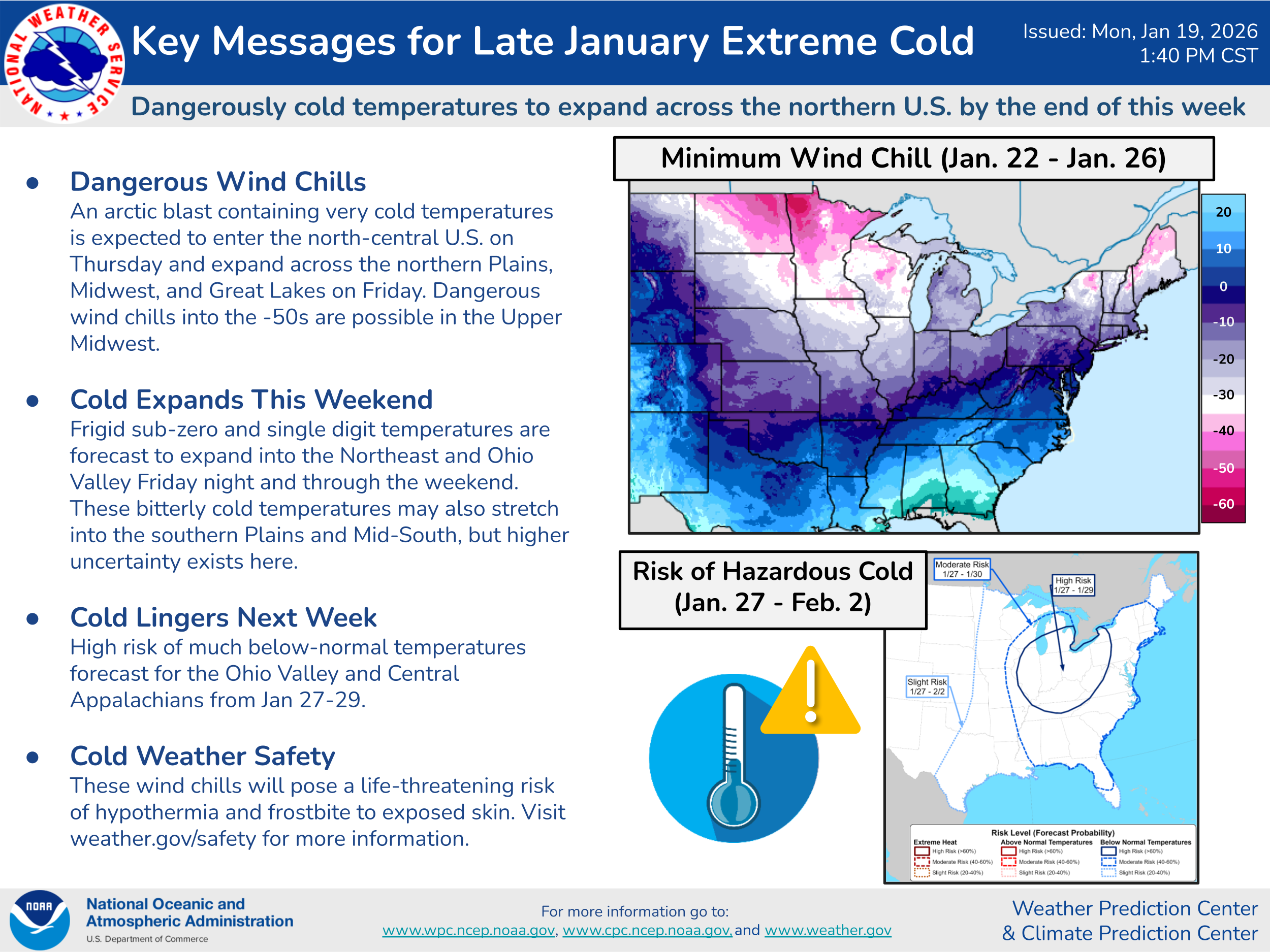
Obviously, along with the high impact winter precipitation, brutally cold weather will be a serious concern, again well summarized by this WPC key messages graphic. The upper Midwest will of course see the core of the coldest air, with surface temperatures as low as the -30s and wind chills in the -50s possible this weekend. As noted in the graphic, how far south extreme, record cold penetrates remains uncertain, but certainly it will be possible for unusually cold air to spill into the Southern Plains, Mid-South and Tennessee Valley regions by late this weekend into early next week, particularly if widespread heavy snowfall occurs.
If you are in the areas potentially impacted by this extreme cold and/or winter storm, now is the time to start thinking about necessary preparations and beginning any steps that require a longer lead time. I will be providing updates via my daily Substack posts, as well as Substack notes and Bluesky posts. I am also planning to do some live chats (a paid subscriber benefit) and potentially some videos this week to discuss some of the more technical details and the implications of some of the uncertainties and model differences. More to come…

Leave a comment