Widespread and serious impacts from major ice accumulations, very heavy snowfall and extreme cold anticipated across a large swath of the country
Jan 22, 2026
Sorry I am a little late today, but I have been doing media interviews about the impending winter storm and trying to sort through all of the data surrounding this major event. Let’s get into it.
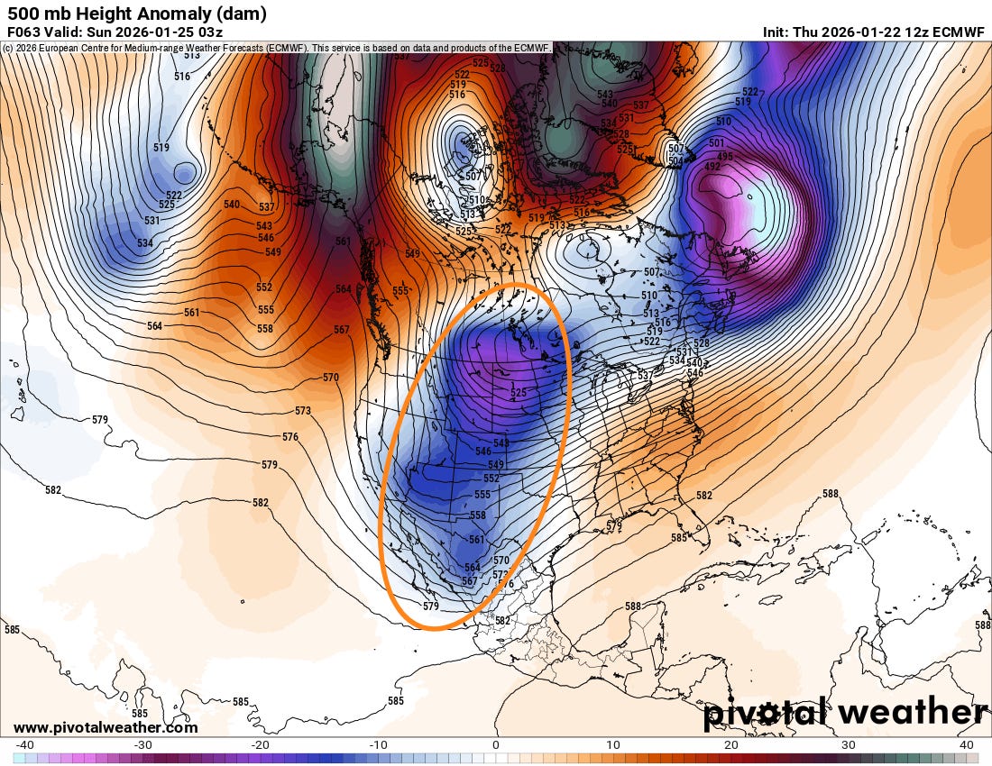
As we get closer to this major impactful winter storm, luckily the models seem to generally be starting to converge on the large scale weather pattern that will be driving it. Above is the 500 millibar (~18K ft AGL) forecast for Saturday evening from this morning’s European model — and it continues to show its trend toward a stronger, larger and more “phased” upper level low pressure system across the western and central US. The other models are generally trending in this direction now, and while there is still of course uncertainty in the forecast, there is enough confidence and we are getting close enough to the event where we can start to focus a bit more on specific potential amounts and impacts.
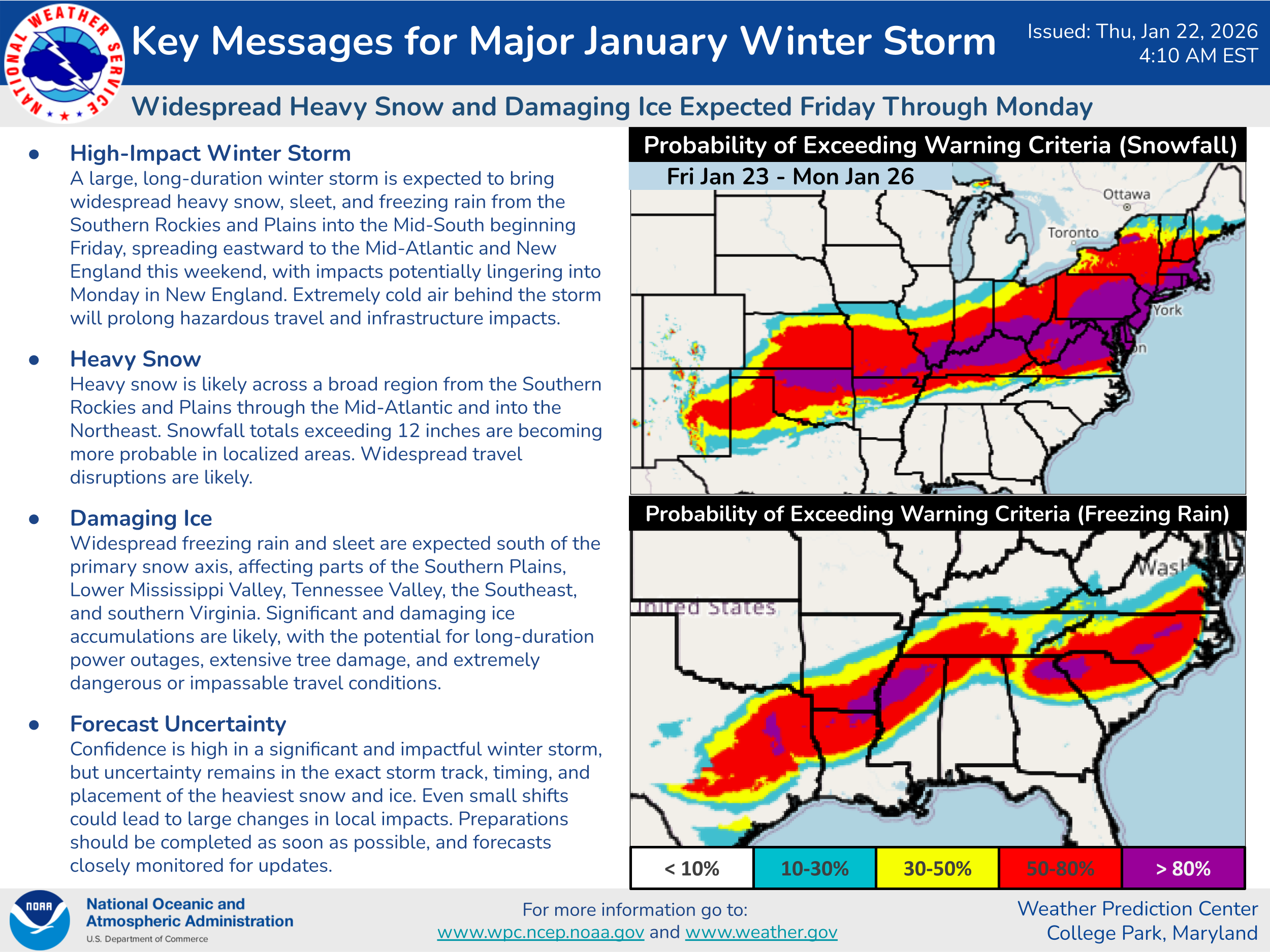
As shown in the NWS Weather Prediction Center key messages above, a broad swath of heavy snow is anticipated from the Southern Plains across the Mid-Mississippi Valley and into the Mid-Atlantic and Northeast, with localized accumulations of a foot or more expected. Farther south, a broad region of heavy — and in some spots, potentially very heavy and catastrophic — accumulations of ice are possible from central and northeast Texas across the Arklamiss Delta and into the Tennessee Valley, and also from northern Georgia across the Carolinas. In between these two areas, more mixed precipitation is anticipated including potentially heavy accumulations of sleet.
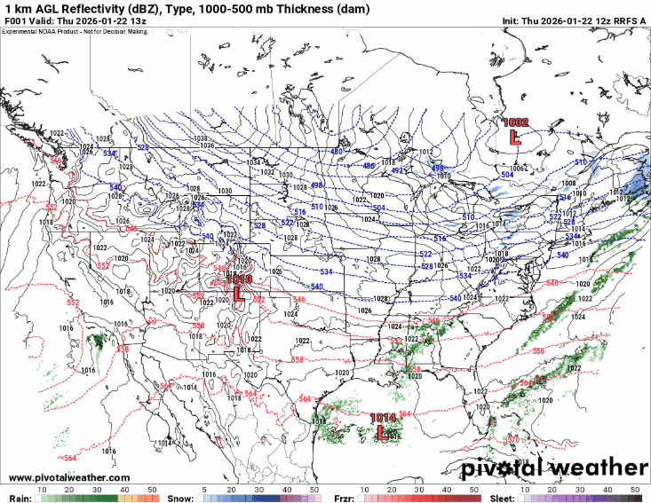
The above animation is the forecast of radar depiction of precipitation from this morning’s Rapid Refresh Forecast System (RRFS) for the next 84 hours (through Sunday evening). I am not showing this with the idea of it being a perfectly accurate forecast, but rather to give you an idea of the overall timing of precipitation that can be expected over the next few days. Wintry precipitation should expand in coverage and intensity across the Southern Plains Friday and gradually expand east through the weekend, with most of the impacts in the Mid-Atlantic and Northeast coming Sunday into Monday. Multiple waves of moderate to heavy precipitation will affect the south central part of the country through the weekend, which will help to bring particularly heavy accumulations of wintry precipitation here.
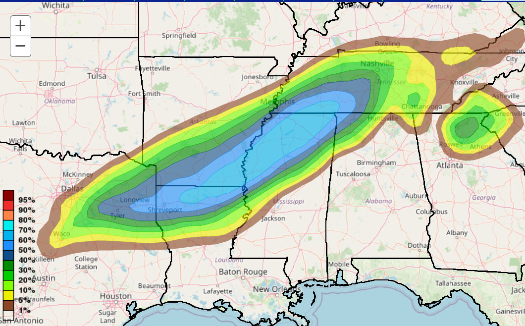
While obviously the expansive high end impacts from heavy snow are of serious concern, my greatest focus right now is on the potential for major accumulations of ice from freezing rain. Above is the most recent WPC forecast for the probability of greater than .5” of ice in 24 hours ending Sunday at 6 am CT, and you can see very high probabilities from the Arklatex across the Delta and into southern Tennessee. Concerns for these sort of heavy ice accumulations will also exist eventually across the Carolinas as well.
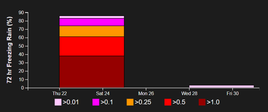
Some of this morning’s model forecasts show the potential for 1-2” of ice in some of these areas, and this probabilistic graphic from the NWS National Blend of Models for Oxford, MS shows about a 40% chance of more than 1” of ice accumulation. Widespread ice accumulations of greater than .5” would likely result in massive damage to power infrastructure and trees in the region which could mean prolonged power outages and serious impacts to travel.
This is particularly concerning given that the weather pattern looks as if it will continue to support well below normal temperatures and periodic blasts of arctic air. Prolonged power outages would be a serious threat to life and property when combined with extreme cold, especially in the South where many homes are not as well insulated or prepared for cold weather.
Again, I will continue to provide updates via Substack notes and posts, as well as BlueSky and Facebook posts. We had a great live chat with a number of paid subscribers yesterday to talk about some of the technical aspects of the forecasts for this event and I was able to answer a number of specific questions. I intend to do a couple more of these through the weekend, as well as potentially some videos. Stay tuned — and of course in your under risk from this winter weather event, continue to also closely monitor local sources of forecasts.

Leave a comment