Record cold, strong winds for many area, as major winter storm focuses snow, wind and coastal flooding impacts on the Carolinas
Jan 30, 2026
Happy Friday – we are looking at another weekend of very complex weather across the eastern United States with the potential for multiple major impacts. The overall scenario has come into pretty good focus — but due to the complexity and the fact that the development of the intense low pressure system that will drive significant impacts for parts of the Southeast and Mid-Atlantic will hinge on smaller scale atmospheric features, there are still uncertainties. I am going to use today’s newsletter to go into a chronological deep dive of it all.
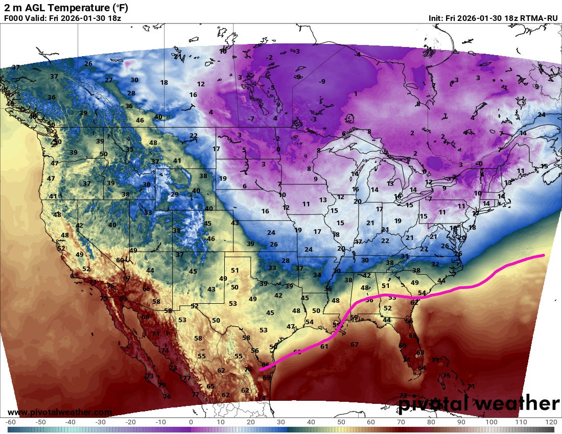
Starting with what is happening now, I have sketched in with a purple line on the current temperature analysis the approximate location of a stationary front that separates warmer and moister Gulf air from colder, polar air to the north. A new surge of Arctic air is coming into the Midwest and Northeast with temperatures in the single digits and teens.
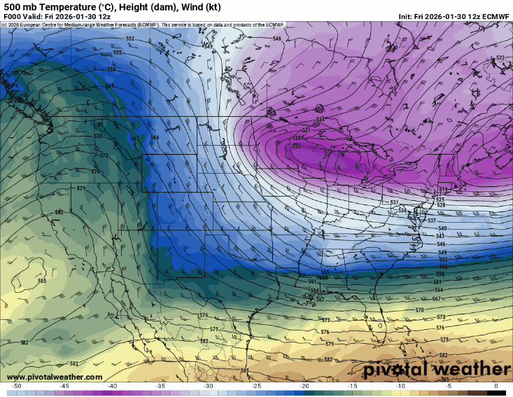
This surge of Arctic air is being driven south by an unusually intense middle and upper level disturbance that is diving south from eastern Canada towards Florida. This animation of heights and temperatures at 500 millibars (~18,000 ft AGL) from this morning’s European model shows the forecast path of this disturbance, with temperatures at this level as cold as -40C moving into parts of the Southeast.
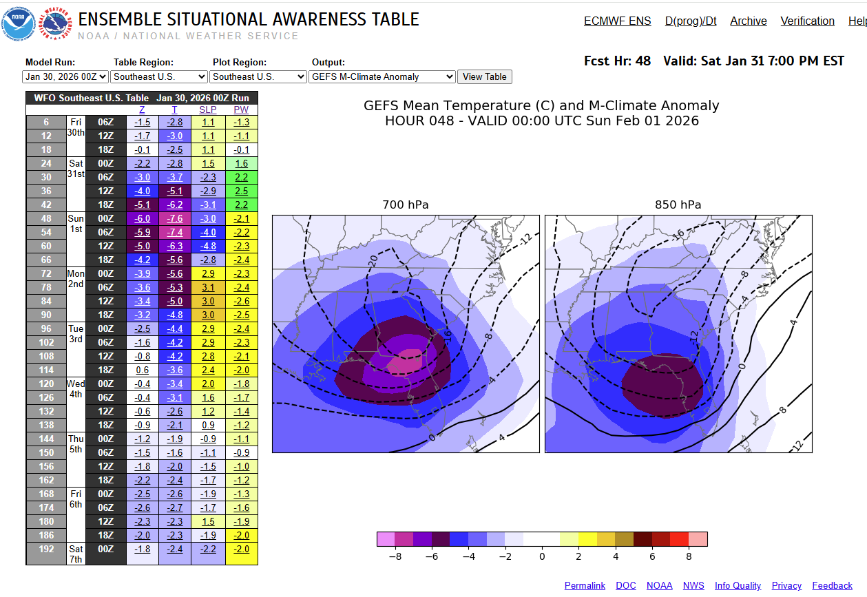
The extreme cold air at the heart of this disturbance shows that this is truly a piece of the middle atmospheric polar vortex being forced south by unusually warm air that has been in place for weeks over much of the Arctic region, particularly around Greenland. The NWS Ensemble Situational Awareness Tool shows that the temperature at 700 millibars (~10,000 ft AGL) will reach nearly 8 standard deviations below normal across the Southeast tomorrow evening (thanks to my colleague Jeff Craven for this graphic). Record cold temperatures at all lower and middle levels of the atmosphere are possible across the region (note that upper air data records only goes back to around the 1950s).
As the energy and incredibly cold air aloft with this disturbance starts to interact with the intense temperature gradient between the polar air to the northwest and Gulfstream enhanced warm, moist air over the Atlantic, a low pressure system will develop and explosively intensify off the coast of the Carolinas Saturday and Saturday night.
The various models of course have differences in the exact amount of intensification — or “deepening” — of the surface low, but the morning European model (shown above) shows the low deepening from 1008 millibars (mb) at 7 am ET Saturday to 971 mb at 7 am ET Sunday, or 37 mb in 24 hours. Most people have now heard the term “bomb cyclone” and the definition for that: a storm that deepens 24 mb in 24 hours. However, the actual criteria a “bomb” is latitude dependent, and 24 mb/24 hr is for a storm at 60N latitude. For a system at 25N latitude which this low is closer to (it’s at about 33N) it only takes 12 mb of deepening in 24 hours as it is “harder” to get lowering pressure the farther south one goes. According to the European forecast, this low will actually deepen 26 mb in 12 hours Saturday night — an incredible rate of intensification for a low at this latitude.
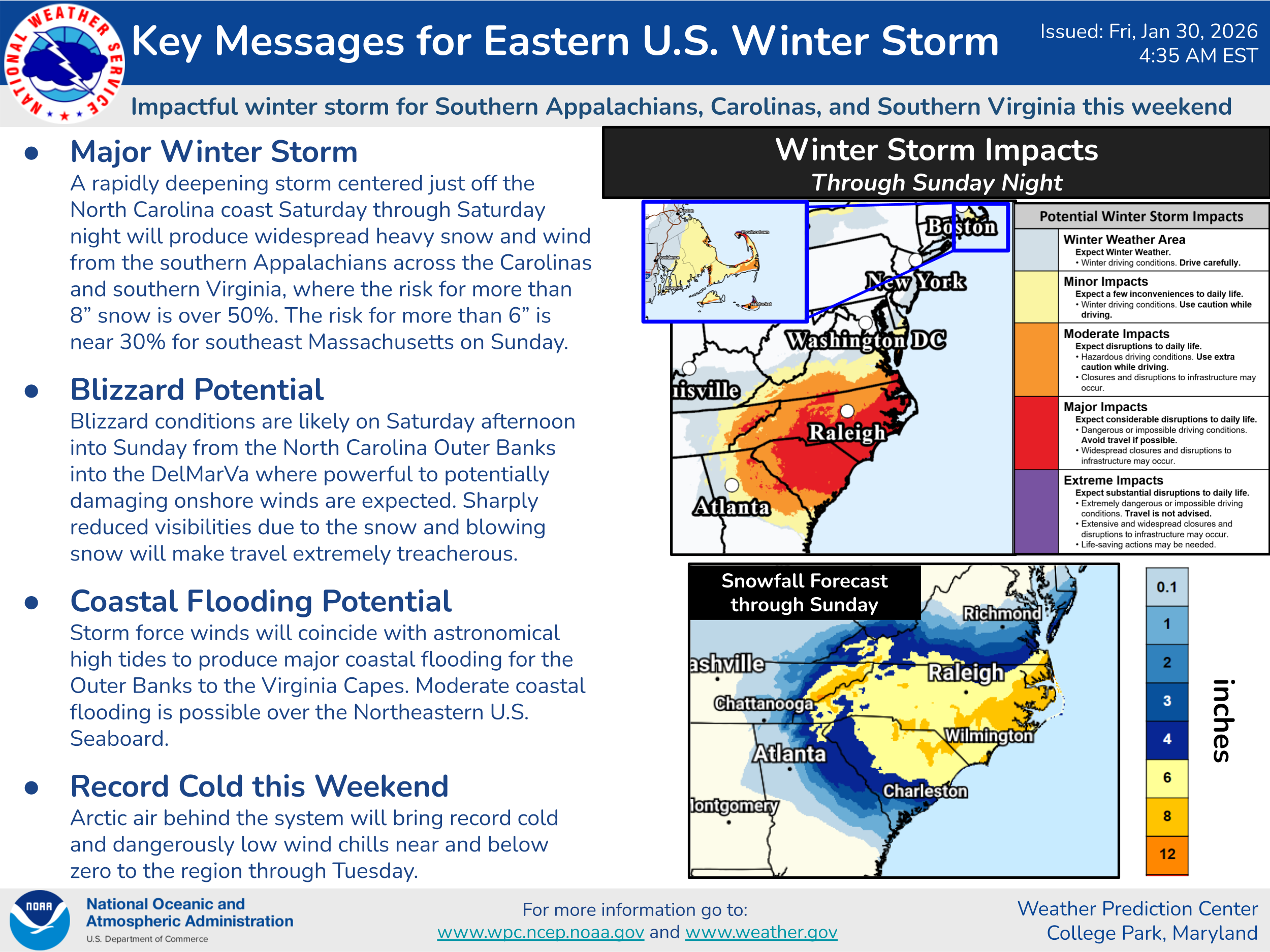
While we are lucky that this low will be moving east-northeast away from the Mid-Atlantic coast and more out to sea, it will still be close enough to produce major snowfall, wind and coastal flooding impacts centered on the Carolinas as well as adjacent parts of Georgia and southeast Virginia. Needless to say, there will be a lot of complex atmospheric processes going on with this storm system, which will lead to localized maxima and minima in impacts that will be difficult to anticipate. The NWS Weather Prediction Center key messages above do a great job of describing the situation, with the graphics probabilistically showing the impacts and the most likely snowfall totals as of now. Note that even though the low will be pulling away to the east-northeast on Sunday, it will move close enough to southeast New England to cause some snow and wind, primarily for Cape Cod and the Islands as shown on the graphic above.
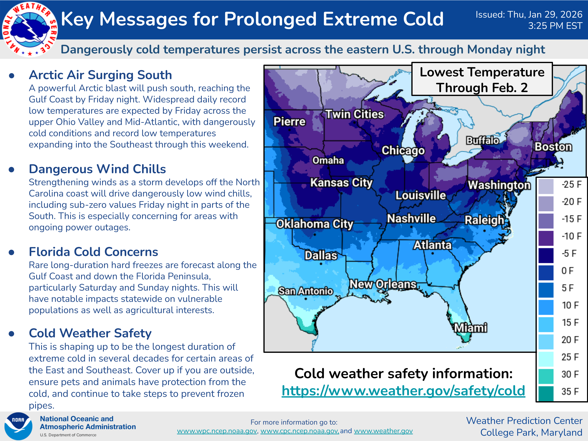
The other major story will be the wind driven extreme cold in the wake of this developing storm. Arctic air will continue to surge south tonight into Saturday, and even colder air will be pulled south as the low winds up and strong north to northwest winds develop across much of the Southeast.
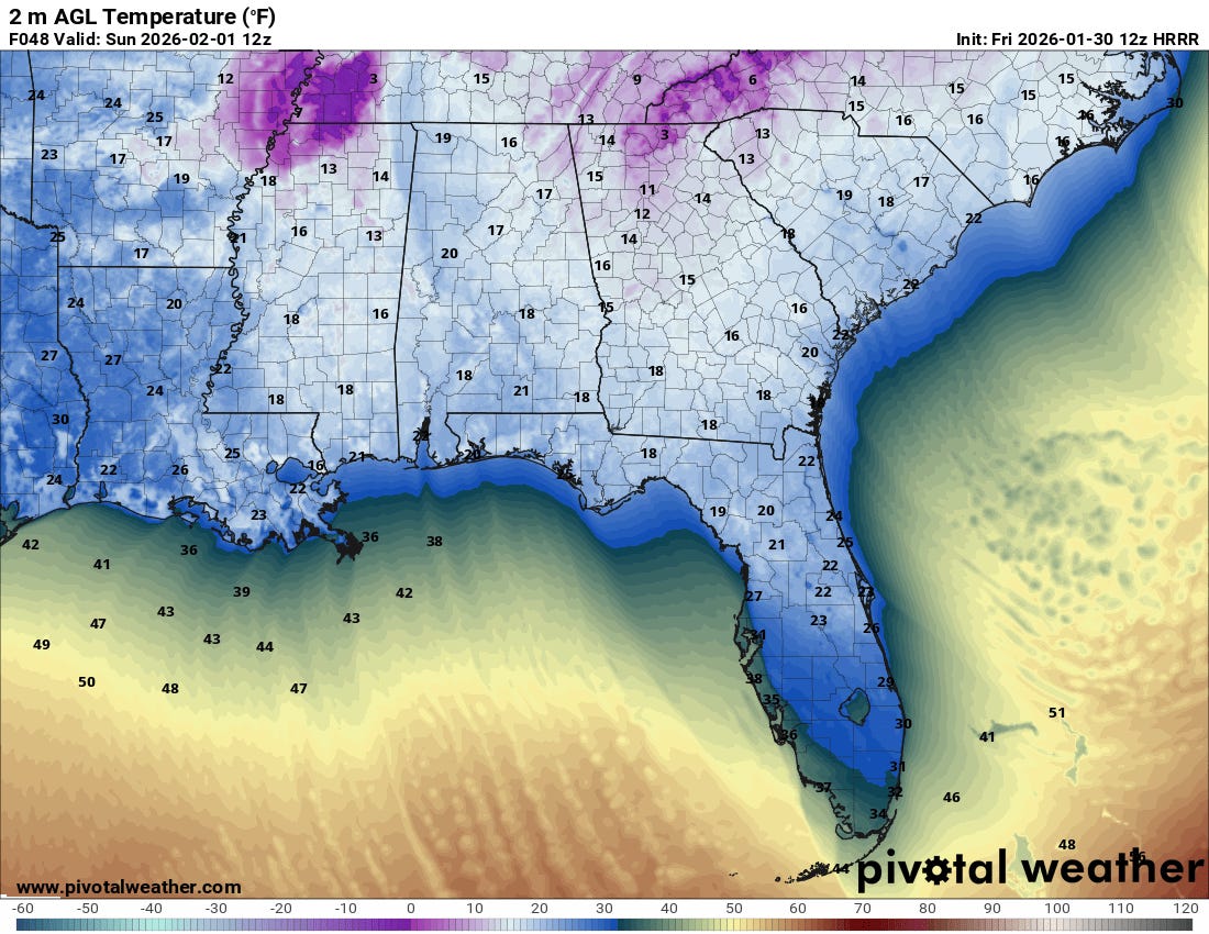
This will drive unusually cold air well south into Florida, with the potential for a freeze all the way south to parts of the Miami area (High Resolution Rapid Refresh forecast of 7 am ET Sunday temperatures above). This will result in numerous record lows in Florida and adjacent parts of the Southeast coastal region — farther north and west, while temperatures will be bitterly cold, they will not generally be record breaking.
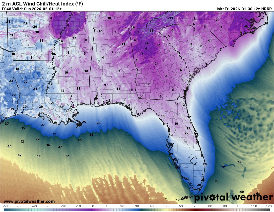
The record cold combined with the strong winds will result in almost unheard of wind chill readings across Florida with some single digits possible north of the I-4 corridor. Unusually cold single digit and in some cases subzero wind chill readings will be widespread across the Southeast on Sunday morning.
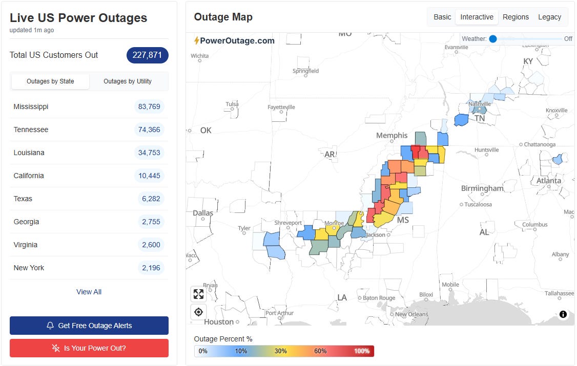
Again, I cannot overstate the particular concern from this extreme cold that exists in the areas reeling from the ice storm last weekend, with more than 200,000 customers still without power. Additional power outages will be possible across the Southeast this weekend — both directly due to the snow and winds from the major storm system, and in these ice storm impacted areas as strong, gusty winds impact heavily damaged trees and power infrastructure.
I will be providing updates on this weather situation through tonight via Substack notes and social media posts, and will also likely do a live chat at some point this afternoon or evening. Paid subscribers will receive a note when I schedule that.

Leave a comment