In fact, data strongly shows extreme cold is getting less frequent with time globally
Feb 03, 2026
With the weather finally in a bit of a quieter mode for the US, I want to continue to follow-up on the what and why of the last couple of weeks of busy active weather, as well as take a look at some global weather news stories.
Whenever we go through a particularly cold period in the US, social media is generally full of posts from both sides of the climate change “debate”, with skeptics saying “what happened to global warming” and some advocates implying that climate change somehow makes cold waves more intense and/or frequent. As I alluded to in yesterday’s post, neither of these perspectives have much (any?) validity.
To look a little deeper from my perspective: there is some climate change research that suggests that greater warming at the poles versus the tropics is causing the jet stream to slow down and become more “wavy.” This seems to be resulting in longer periods of more persistent patterns where the jet stream is can get locked into rather stable, amplified configurations. We have seen such a stable pattern across North America much of this winter with a large upper level high pressure area over the West and downstream upper level trough over the East.
This sort of weather pattern leads to frequent weather disturbances moving southeast out of Canada across the eastern United States, capable of tapping into cold polar air. If the corresponding high latitude pattern is also favorable, this means that bitterly cold Arctic air can surge south.

The Arctic Oscillation (AO) is a teleconnection index that meteorologists use to monitor that high latitude pattern. In simple terms, when the AO is negative, it favors warmer than normal conditions in the high latitudes and a pattern that supports Arctic air being forced south into the mid-latitudes. You can see in the top graphic that the AO has been very negative over the last few weeks, meaning that the weather pattern we have been seeing over the US has been able to transport unusually cold Arctic air well to the south.
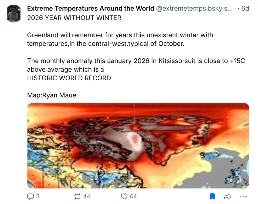
Another consequence of this weather pattern is that the Arctic areas of northern Canada and Greenland have been seeing record warmth as noted in this post from Extreme Temperatures Around the World, with parts of Greenland seeing a record warm winter so far and periodic temperatures above freezing, unheard of during the winter. These warm anomalies are larger than the corresponding cold anomalies farther south, because the overall global climate is warming.
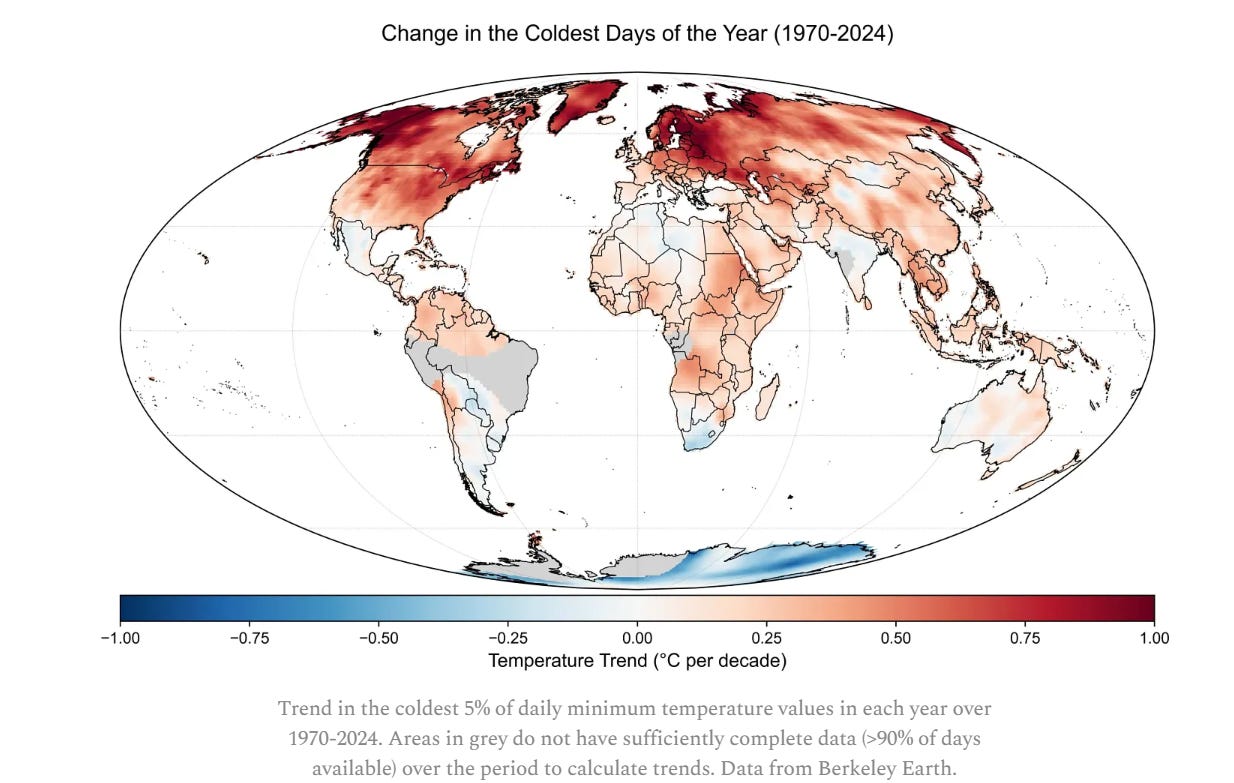
Noted climate scientist Zeke Hausfather reposted yesterday his excellent article explaining the climate science that clearly demonstrates that nearly all of the globe is seeing extreme cold become a less frequent phenomena, as shown in this graphic from his article above.
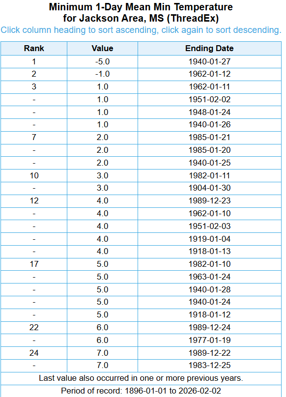
Of course, we can see these trends in climate data for local communities, and I will share a couple of examples for illustrative purposes. When I first became an NWS meteorologist in Jackson, MS in 1996, I did a winter climatology for the region and found that on average Jackson observed single digit or subzero low temperatures about once every four years. You can see in this screengrab from the XM-ACIS climate data website that the top 25 coldest minimum temperatures in Jackson are all 7F or colder — you can also see that they are all from 1989 or earlier.
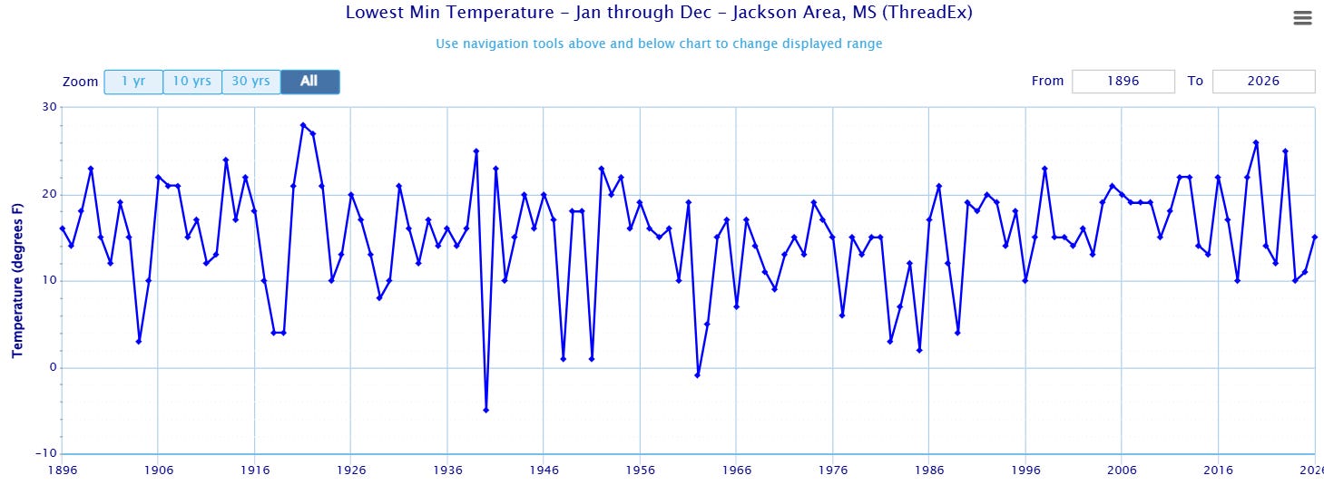
In fact, Jackson has not seen a low below 10F since 1989 (it has hit 10F exactly a few times) — in this particularly cold stretch over the last few weeks, the coldest temperature observed there was 15F, 20 degrees warmer than the all-time record low of -5F set in 1940.
As I talked about in my Sunday post on my central Florida weather focused Fairy Dust Forecast Substack, you can see a similar trend in data for Orlando. The daily mean temperature at Orlando Int’l Airport on Sunday was 35F, which tied with January 9, 2010 and January 24, 2003 for the coldest daily temperature in the 21st century, and was the coldest February daily temperature since 2000. However, to give you an idea of how much the climate has evolved in the last 150 years, this only ties for the 24th coldest daily temperature on record at Orlando, where records go back to 1892.
Obviously, this does not mean that the cold weather we have seen over the last two weeks is not extreme. As my colleague Victor Murphy pointed out to me, the morning low of 24F at Orlando on Sunday was the coldest February low temperature in Orlando since 1917, and West Palm Beach had their first subfreezing low temperature since 1989. Cuba set a national record low temperature of 32F, and the Bahamas set a record low maximum (thanks to Extreme Temperatures Around the World for highlighting these records) during this cold wave.
Record cold will still happen, but the bottom line is that all of the data strongly supports that extreme cold is becoming less frequent and less “extreme” when looked at from a long term, global perspective. For an interesting perspective on the societal implications of this, I suggest watching this short video from my colleague Daniel Swain about how the intense cold waves that do still happen could be particularly impactful against the backdrop of global warming trends.

Another area that has been dealing with severe winter weather in recent weeks is Japan. The northern island of Hokkaido is one of the snowiest places on Earth, but particularly cold weather in recent weeks has led to unusually heavy snow for even this climate, with feet of snow causing roof collapses and leaving 30 people dead.
In the Southern Hemisphere where summer is ongoing, heat related issues have been a serious problem in recent weeks. Australia had its fourth hottest January on record, with multiple heatwaves impacting the company. The Australian Broadcasting Company did a fascinating article highlight studies that show how more frequent heatwaves are changing Australians’ spending habits. Meanwhile, Chile is recovering from January wildfires that left 19 dead and destroyed hundreds of homes.

Taking a quick look at US weather, today will see another storm system moving across the eastern United States, but rain and thunderstorms will be the predominant precipitation type as warmer Gulf air surges north. Some wintry precipitation will occur in the Mid-Atlantic and Ohio Valley on the northern fringe of the precipitation shield. Warmer than normal and mainly dry weather will continue over the West.

That storm system will continue to move toward the coast by Wednesday, with some light freezing rain and mixed wintry precipitation possible over the Mid-Atlantic with rain and storms farther south. Most of the rest of the country will be dry.

Leave a comment