Bill moves to full Senate for consideration. Other news: WMO retires the name “Melissa” from the Atlantic tropical cyclone naming lists, severe weather a risk in central US next several days.
Mar 04, 2026
This morning, the Senate Committee on Commerce, Science and Transportation held a “markup hearing” on the recently introduced Weather Act Reauthorization bill which was introduced by committee leadership last week, and which you can read more about in my post here. The markup hearing is the committee’s formal process to discuss the bill, approve amendments, and finally vote on the bill — once the bill is approved by the committee, it goes to the full Senate for consideration.
In their opening remarks for the hearing, both committee chairperson Sen. Ted Cruz (R-TX) and ranking member Sen. Maria Cantwell (D-WA) noted that this bill is the result of extensive work by the committee’s members and their staffs, and helps bring together a number of pieces of legislation related to NOAA’s weather programs that have been drafted by committee members. This includes the TORNADO Act and legislation to establish the Radar Next weather radar modernization program. Sen. Cruz in his remarks emphasized that the Weather Act would ensure that NOAA remains focused on its core public safety mission:
The Weather Act updates the National Oceanic and Atmospheric Administration’s research and forecasting programs, ensuring that the agency remains focused on its core public-safety mission. The bill is aimed at improving the accuracy and actionability of forecasts and weather warnings, as well as modernizing weather systems. It addresses hurricanes, tornadoes, wildfires, landslides, droughts, and atmospheric rivers. It will go a long way toward modernizing radars and satellites, leveraging commercial data, and integrating artificial intelligence capabilities into NOAA programming. I am also happy to say the bill will reform the NOAA Weather Radio program, a critical safety system that I worked to improve following the tragic floods we saw in Texas last July. All told, the Weather Act packages multiple bipartisan pieces of legislation, many of which have previously passed out of committee and five of which passed the Senate last session.
Sen. Cantwell discussed the massive floods that impacted her home state of Washington in December and how that event and the more than $100B in weather related damage in 2025 demonstrates the need for the programs authorized in the Weather Act: “We should not underestimate how important this is to our nation’s continued success in letting our citizens know how important science is to determining where we put resources and how we help our citizenry…the Weather Act will ensure that America’s weather enterprise is nimble, innovative and equipped to meet the evolving challenges of the 21st Century.”
You can watch the full committee hearing here which also included the markup for a similar authorization bill for NASA (which appears to have limited implication for NASA’s atmospheric science programs). In the end, the Weather Act bill passed the committee unanimously and it was sent forward for full Senate consideration. A handful of amendments were added to the bill during the final approval process that will be integrated into the draft bill to generate the final bill that goes to the full Senate for consideration.
I will be discussing this bill in more detail in the coming weeks and months, but want to emphasize that at a high level all indications are that this bill being approved by Congress (it needs separate House approval in addition to Senate passage) and signed into law by the President would be a tremendously positive step (in my opinion) for the weather community. It would formalize the intense bipartisan Congressional pushback against the Trump Administration’s plans to reduce and reorganize a number of NOAA weather programs. For example, the bill would legislatively authorize the Office of Oceanic and Atmospheric Research (OAR) and its weather focused research programs such as VORTEX-USA.
The bill would also authorize a number of new initiatives, including the Radar Next program to develop the crucial weather radar infrastructure to replace the aging NEXRAD Doppler radar network, atmospheric river research programs, new social and behavioral science efforts to improve weather communication and warnings to the public, and a Fire Ready Nation initiative. Obviously, more to come as this bill navigates the legislative process.
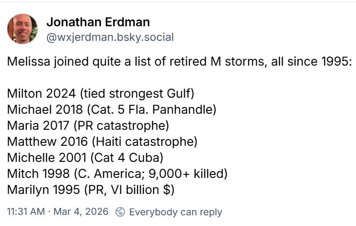
Another breaking news item this morning is that the World Meteorological Organization (WMO) Hurricane Committee officially retired the name “Melissa” from its list of hurricane names, meaning the name will never be used again for an Atlantic tropical cyclone. The WMO maintains the lists of tropical cyclone names used around the world, and retires names from the list when a storm causes sufficient impacts that it is deemed that it should not be utilized by any future storm. The name “Melissa” will be replaced with “Molly” going forward.
Just last week, the National Hurricane Center issued its final post-storm summary report on last year’s Melissa, and determined based on analysis of observational data such as reconnaissance aircraft and satellite data that Melissa was actually slightly stronger than real-time estimates indicated. NHC now says that Melissa’s peak sustained winds reached 190 mph while it was offshore of southern Jamaica, which means it ties with Hurricane Allen in 1980 as the strongest hurricane on record ever in the Atlantic basin.
My colleague Jonathan Erdman from the Weather Channel noted on Bluesky that the list of retired “M” storms has gotten long and sadly impressive:

I have spent a lot of time in today’s newsletter on breaking news, but do want to note that severe weather continues to be a risk over parts of the central United States the next several days. The Storm Prediction Center (SPC) now has an enhanced (level 3 of 5) risk of severe storms in place for Friday afternoon and evening as can be seen in the graphic above. I will note that there is still some uncertainty surrounding Friday’s severe weather risk, and that most of the AI guidance shows the higher probabilistic risk focused farther north over the mid-Missouri valley. Obviously, we will hone in on that risk over the next 24-36 hours.
SPC has also added a severe weather risk for next Tuesday and Tuesday night. Again, there is still a lot of uncertainty at that time range, but there are certainly indications in some of the ensemble forecasts for the potential for that to be a higher end severe weather day.
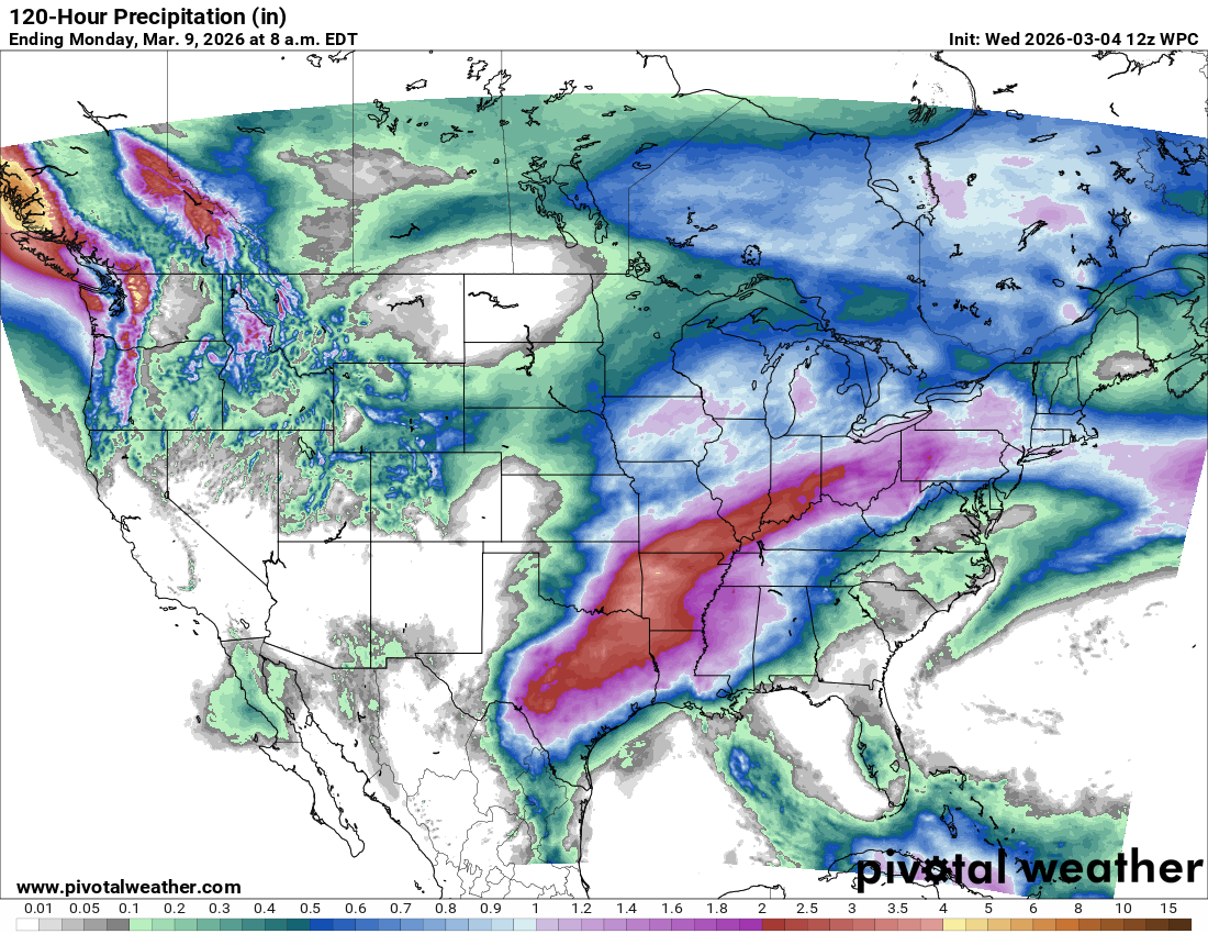
Again, while most of the rainfall with this active weather pattern will be beneficial, there will be the potential for some localized flash flooding due to high rainfall rates and the potential for some training of thunderstorms.

Leave a comment