March 22
One of my goals with this Balanced Weather substack is to bring more awareness to weather events that are happening globally. So I want to start off today by taking a quick look at what temperatures are doing across the planet as we start off this weekend.

While you can certainly see some pockets of darker blue (well below normal) temperatures (central Canada, parts of Antarctica), as is pretty common these days the darker reds (well above normal temperatures) are more prevalent, with large swaths of Europe, Asia and northern Africa well above normal. A number of locations in these areas are experiencing record warmth, in some cases records for the month of March or record for so early in the year. Lark Harbour, Newfoundland in Canada set a monthly record high at 19.5C, and St. John’s, NL had their earliest 17C maximum on record (reached 17.5C); locations in Algeria, Mali, Kazakhstan and Siberia set monthly record maximums, and locations in Siberia and Mongolia set record warm monthly minimums (information from Extreme Temperatures Around the World).

NOAA’s National Centers for Environmental Information (NCEI) maintains a running tally of temperature records both within the United States and globally. As you can see above, both daily and monthly records of warmth significantly outpace cold records. For the last 365 days, daily warm records are about 5 to 6 times more common than cold records, and warm monthly records around 8 to 10 times more common than cold monthly records. This trend has been quite persistent in recent years as global warming has continued.
Weekend Weather

Turning back to the U.S., the storm system that brought heavy mountain snows to the Northwest on Friday will continue to move east today spreading some wintry precipitation across the northern tier, including potential freezing rain in northern parts of Minnesota, Wisconsin and North Dakota.
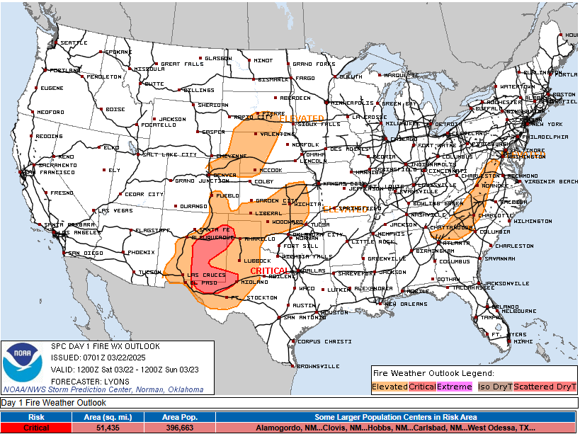
Strong west/northwest downsloping flow on the southwest side of this system will combine with dry air to produce widespread elevated to critical fire weather conditions across parts of the southern Rockies and the central and southern Plains. The most critical conditions will be in eastern New Mexico and parts of west Texas. Winds will be gusty – though not the extreme winds seen in recent wind/dust events in this region – along with widespread relative humidity values below 10%, resulting in conditions favorable for rapid fire growth and spread.
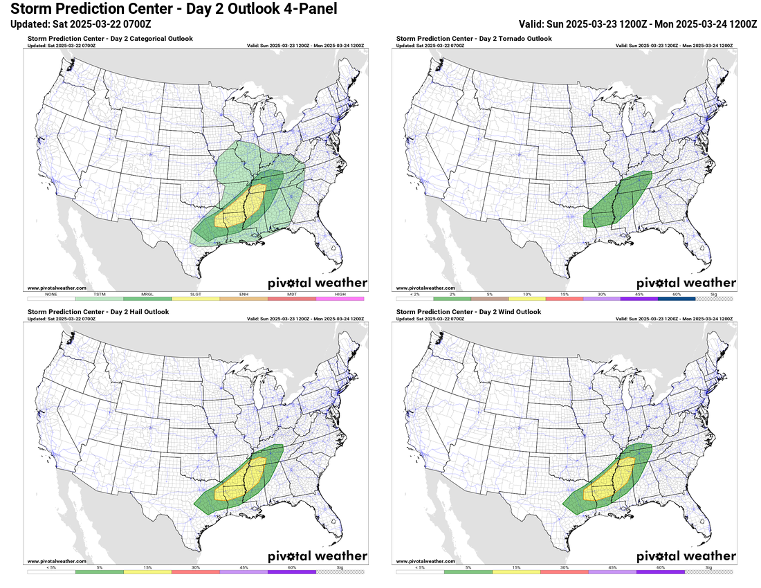
Later on Saturday and especially on Sunday, this weather system will begin to interact with modest Gulf moisture return to produce scattered thunderstorms over the middle part of the nation. Conditions will become somewhat supportive of severe thunderstorms on Sunday from the Arklatex into the lower Mississippi Valley. The track of this system to the north and northeast of the region combined with only somewhat support moisture and instability means that a significant severe weather episode is not anticipated. Still, SPC has outlooked the region in a slight (level 2 of 5) risk of severe storms, primarily for some incidences of damaging winds and large hail. A couple of tornadoes could occur, but wind shear in the lower levels of the atmosphere will not be particularly supportive, and SPC has the lowest level risk for tornadoes (upper right hand image above) forecast. A few severe storms producing hail are also possible this afternoon and evening over parts of Missouri and adjoining eastern Kansas and northeast Oklahoma/northwest Arkansas.

Over the rest of the country, this system will spread some wintry precipitation across the northern tier, including heavy snow in the Upper Peninsula of Michigan and adjoining northern Wisconsin and Minnesota, as well as potential freezing rain in parts of New York and Pennsylvania as shown above.
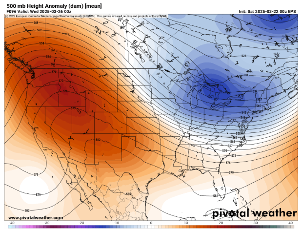
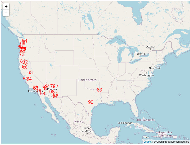
Taking a quick look at the weather pattern for early next week, the overall pattern as shown above in the mid levels of the atmosphere at 500 mb – about 18,000 ft AGL, the level meteorologists use to monitor weather patterns in the mid/upper levels of the atmosphere – shows the western and central United States will be dominated by a large ridge of high pressure, while a trough of low pressure will be centered over the Northeast and Great Lakes. Overall, that will mean cooler than normal weather in the much of the east, while most of the western US will be warmer and drier than normal. A number of locations in the West are forecast to approach and potentially break record high temperatures (both maxes and mins) in the western and south-central United States next week. Below is the map from the Weather Prediction Center showing sites that will be near record high temperatures on Tuesday.
Reference Websites for more info
Climate Reanalyzer, University of Maine

Leave a reply to Balanced Weather Cancel reply