March 29
Good morning! I am on the road today and doing this morning’s post in a McDonald’s. My day is starting with a Sausage McMuffin with egg, hash browns and a Diet Coke – all of which I love – and listening to a guy who has no idea the person in the booth next to him is a meteorologist. He is telling his wife that she should go back to school to be a meteorologist because she’s only right 15% of the time and that’s the only profession she could get paid for that success rate. So…it’s a mixed bag morning.
Anyway, lots and lots of weather to talk about today, so let’s get started.

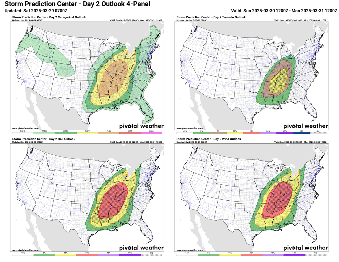
The severe weather setup we have been discussing for this weekend still looks on track, and things seem to be coming into a bit more focus. As the system starts to pull out into the Plains later today and this evening, it should begin to encounter a quite unstable atmosphere across northern Oklahoma and cause the development of scattered supercell severe storms. Conditions look favorable for a few of these storms to produce very large hail, and SPC has a hatched area in their hail forecast to highlight this potential. With time, the storms will likely evolve into more of a complex that could produce damaging winds and hail as it moves northeast into western Missouri before eventually weakening. SPC has a slight risk (level 2 of 5) for this scenario as seen in the top graphic (upper left in the 4 panel).
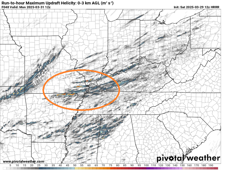
The most widespread severe weather risk – as well as the most impactful potential severe weather – looks to come Sunday afternoon and night as the overall weather system intensifies a bit and moves into the middle Mississippi Valley. As we have been discussing for the last few days, a large area from the Arklatex northeast into Indiana and western Ohio should become favorable for severe storms with a threat for all hazards (large hail, damaging winds and tornadoes), and SPC has a large enhanced (level 3 of 5) risk for this area. Looking at the evolution of the various features, my sense right now is that the greatest tornado risk is likely to be in the region from southern Illinois and southeast Missouri down to around the Memphis area. This is also the area where this morning’s High Resolution Rapid Refresh model shows the most intense storms with the strongest rotation (see below). This is a fairly complex meteorological scenario, and the models still have some disagreement with the large scale features driving it, so we could still some changes to the forecast.

The storm system will continue to move east on Monday with an accompanying risk of severe storms. While not as favorable for severe storms as farther west, conditions look to support a continued risk of some storms with hail and strong winds, and SPC has a large slight (level 2 of 5) risk area outlined.
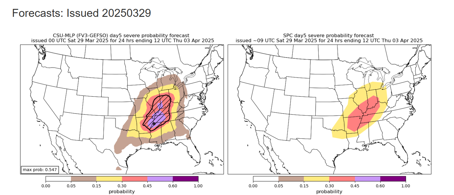
Attention will then turn to the next major weather system forecast to move into the Midwest for the middle of the week. This system should bring an initial risk of some severe storms in the mid-Missouri Valley region Tuesday afternoon and night before the main severe weather episode anticipated on Wednesday. The Colorado State University machine learning system (CSU-MLP) is already showing quite high probabilities over a large area for Wednesday and Wednesday night, including a “hatched area” indicating the potential for significant severe weather (very large hail, winds of 75 mph or greater, or EF2+ tornadoes). SPC has a 30% area outlooked in the same general area (30% probabilities are as high as SPC can go in the day 4-8 outlook). There are still some rather significant differences in the weather models with some models (e.g., European) an even more intense storm system than some of the others. Overall, though this system has the hallmarks of one that could produce a higher end severe weather day, and thus needs to be monitored closely.
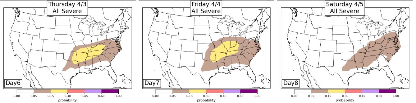
The weather pattern looks to remain favorable for active severe weather through the middle part of the country after Wednesday’s system, with a large trough of low pressure over the western United States. This system will likely eject disturbances out across the middle part of the country which will interact with moisture and instability from the Gulf to yield rounds of severe thunderstorms. While in this sort of a pattern it’s difficult to determine timing and areas at this time range, the CSU-MLP shown above reinforces the potential active pattern, as 15% probabilities as days 6 and 7 are rather high.
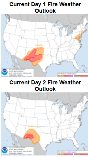
Along with the severe weather risks, on the southwest, drier side of these storm systems we will be watching critical fire weather conditions. SPC has highlighted parts of the southern Rockies into the southern Plains for elevated to critical fire conditions this weekend due to gusty winds and dry fuels/airmass. The midweek system should bring additional fire danger concerns to the same general area.

And last but not least, on the cold side of the weather systems we still have winter weather to deal with. Today a swath of winter weather – including freezing rain – is anticipated from the upper Midwest into northern New England. Ice storm warnings are in effect for parts of northern Wisconsin and Michigan, as well as upstate New York.

Leave a reply to Balanced Weather Cancel reply