April 3

Good morning…after a busy Wednesday, let’s start today but taking stock of where things stand now. The visible satellite image above with GOES satellite lightning mapping array data overlaid shows where our band of of storms has stalled out. As expected, it’s running from West Virginia down to along the Red River; you can see the most intense storms this morning are in southern Oklahoma, and are the strong/severe storms leftover from a cluster of severe storms that affected north Texas in the predawn hours this morning.
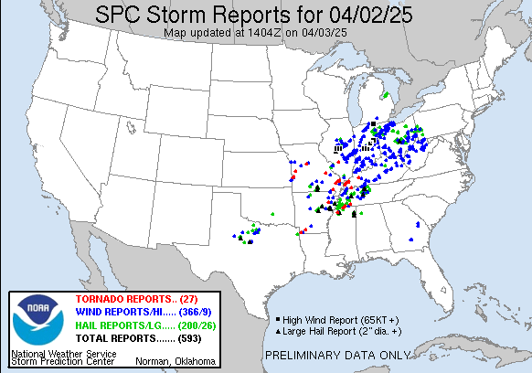
You can see the area of reports of large hail – some greater than 2” – and wind damage with those early morning storms west of the Metroplex on the Wednesday severe storm reports map. In total, there have now been nearly 600 reports of severe weather from Wednesday. I provided a preliminary overview of what transpired through yesterday evening in a post last night. Additional severe weather did occur overnight, including tornadoes in Tennessee. Media reports that 4 people have died from severe weather in the last 24 hours, 3 in Tennessee and 1 in Missouri.
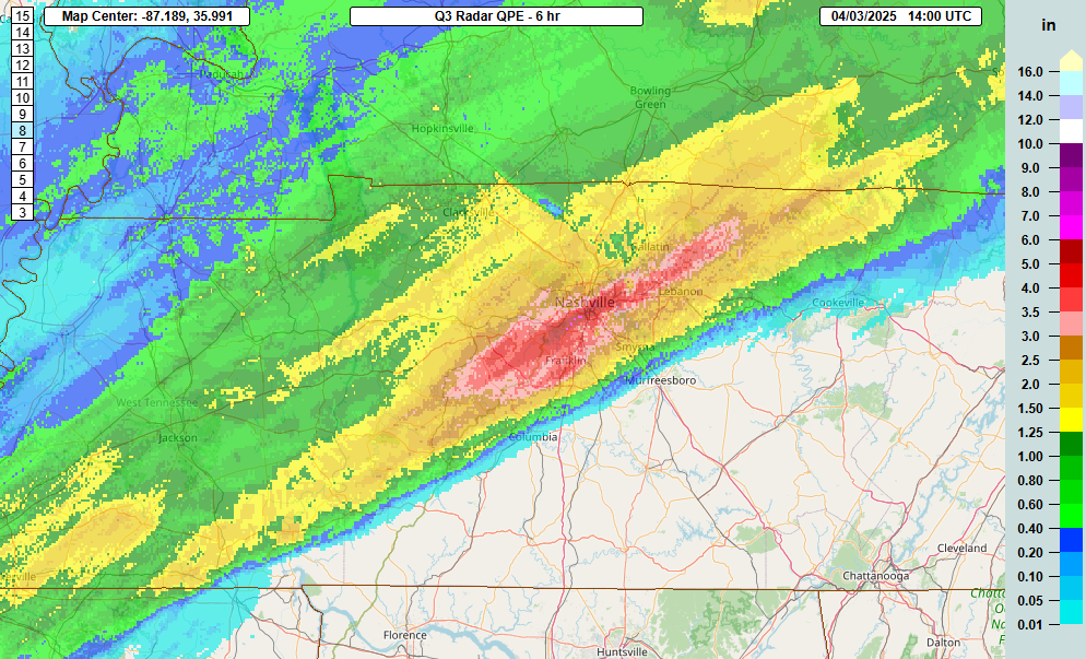
Over the last several hours, an axis of very heavy rainfall (up to 6” in 6 hours per MRMS radar estimates) has set up right through the Nashville metro area, causing considerable flash flooding.
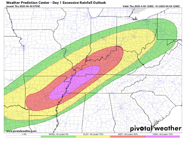
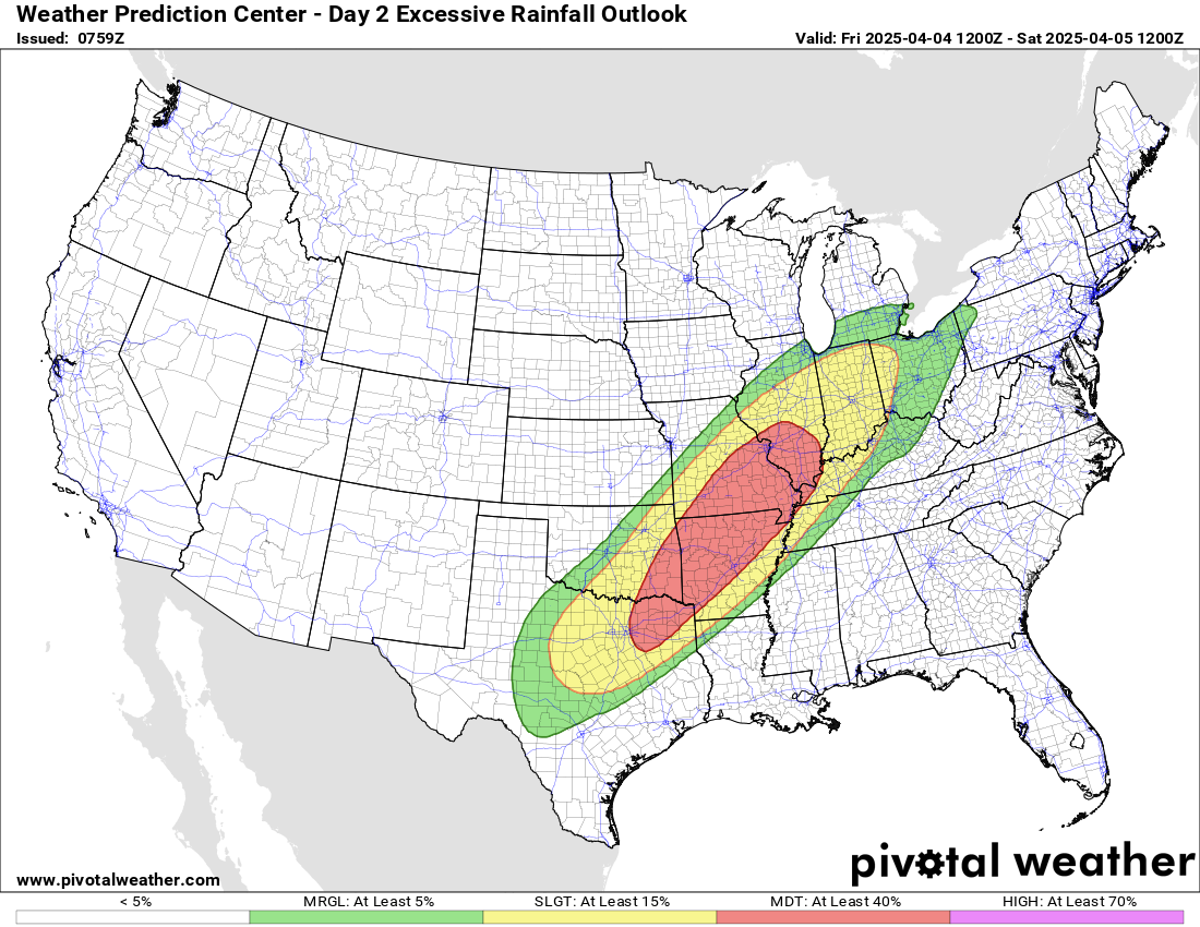
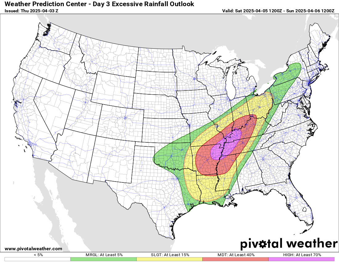
This flash flooding is just the start of what is expected to be a several day period of serious flash flooding. For today, the axis of heaviest rain will shift a bit northwest as the front that has stalled out begins to lift back a bit to the northwest. NWS Weather Prediction Center (WPC) has outlooked a large region from the Arklatex to the Cincinnati area in a moderate (level 3 of 4) or high (level 4 of 4) risk of flash flooding for today.
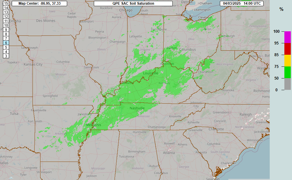
This graphic shows soil saturation as of this morning from the MRMS FLASH hydrologic system, and you can see that soils are already rather wet in this region, so additional heavy rainfall will run off very quickly and potentially create serious flash flooding risks. People living near flood prone areas need to be ready to take action, not just today but over the next few days, as we’ll discuss more below.
In addition to the heavy rainfall risk, the severe weather risks will also increase again this afternoon and evening. As you can see in the visible satellite image above, south of the stationary front, there will be quite a bit of sunshine heating up a very moist and unstable atmosphere, which will help fuel redevelopment of thunderstorm activity.
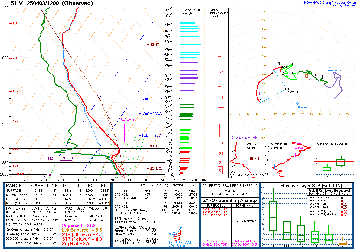
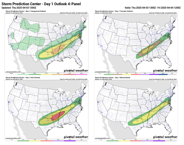
This is the morning upper air balloon data from Shreveport, LA, and it shows a very primed atmosphere for severe weather, with strong wind shear and very unstable conditions. Lapse rates – the change in temperature with height – are quite steep and indicative of the potential for very large hail with any severe storms that form. A few strong tornadoes are also possible in a zone from the Arklatex to near Memphis as depicted in the SPC tornado outlook in the upper right panel of the SPC day 1 outlook shown above.
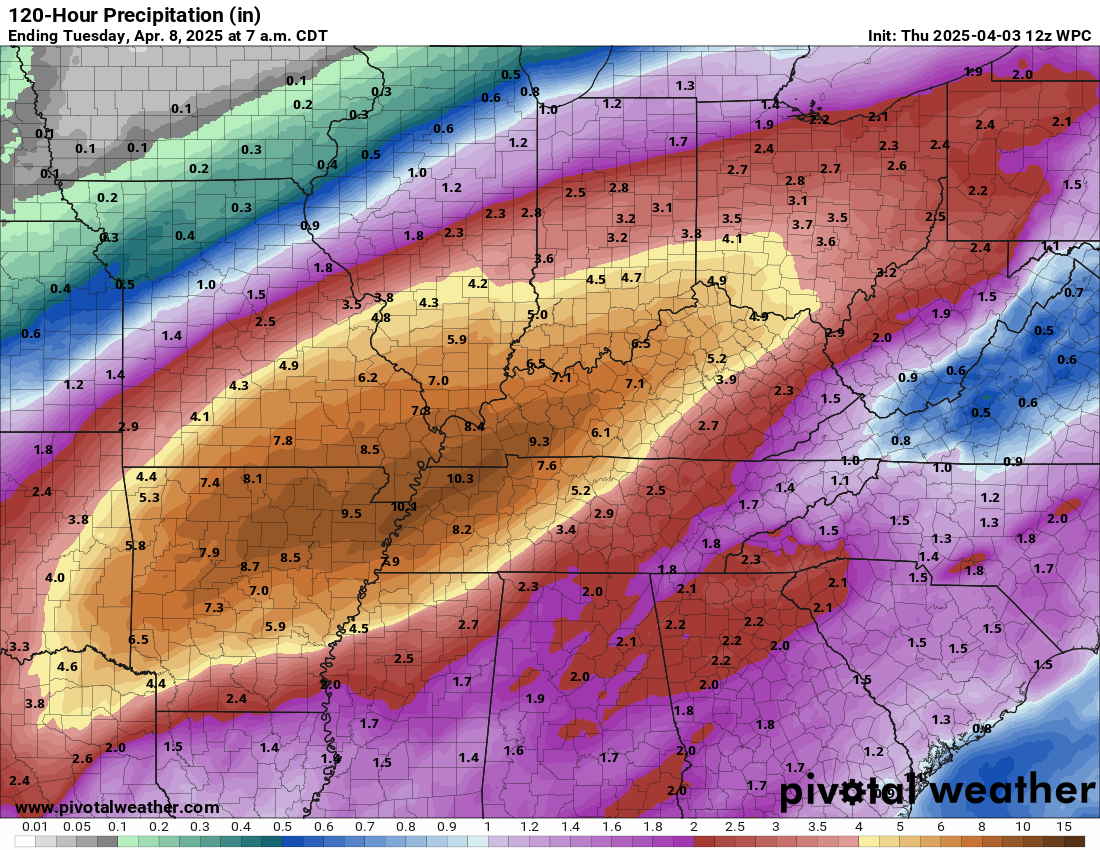
Active weather will continue for the next 48 to 72 hours after today, and the focus will increasingly be on the serious heavy rain and flash flooding risk. As shown in the 5 day total rainfall map from WPC above, additional rainfall of up to 10” is expected in a large swath from the Arklatex right up the Ohio Valley. As weather disturbances eject out from the large upper level of trough of low pressure in the Southwest US we have been discussing, multiple rounds of intense thunderstorms will develop over this region and move repeatedly over the same area.
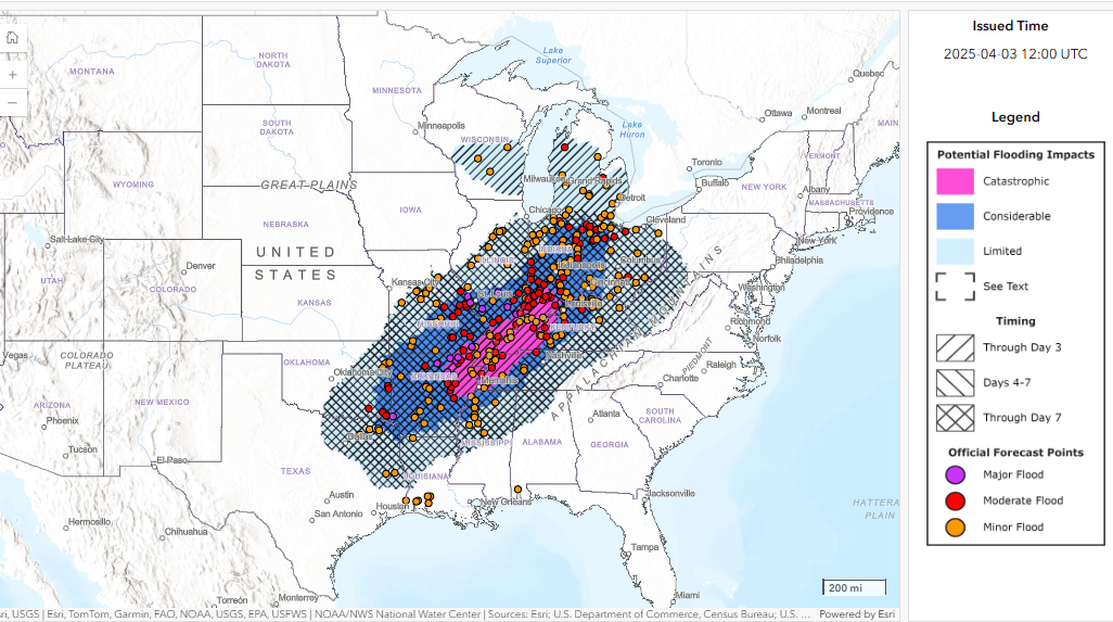
The storms will fueled by near record levels of moisture for the time of year, resulting in potentially catastrophic flash flooding. As rainfall totals build over such a large area, increasingly serious river flooding is also likely to develop. The event should culminate on Saturday with the most intense rainfall as the main Southwest US weather system finally ejects into the region, and when WPC again has a high risk forecast.
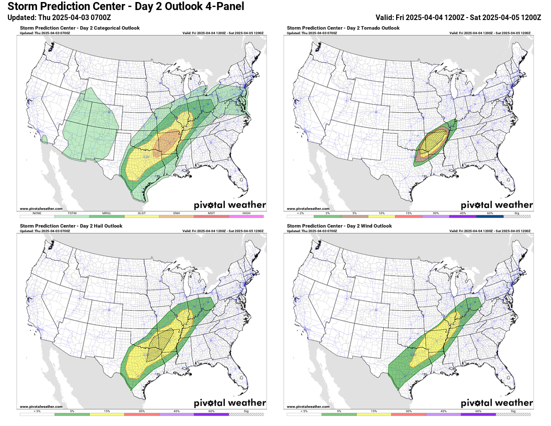
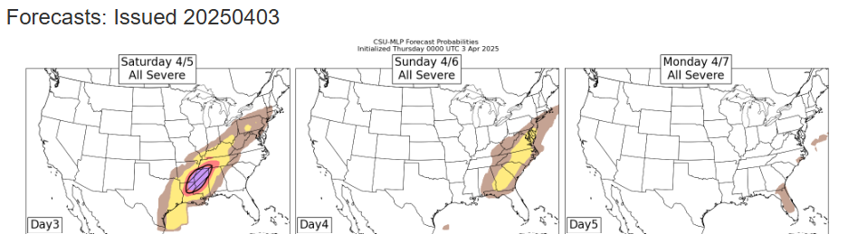
Severe thunderstorms will also be a significant risk the next few days. The SPC day 2 outlook has another enhanced (level 3 of 5) risk for severe storms centered over Arkansas, with strong tornadoes and very large hail again possible. Saturday is expected to bring another day of potentially serious severe weather to the mid-South and lower Mississippi Valley as the main storm system impacts the region. By Sunday, the system will be weakening but will still bring some risk of severe storms to the Southeast as shown on the day 4 CSU machine learning forecast above.
Given the very busy weather, I only have space here for a high level overview of what is expected the next few days. I am planning to continue to provide additional details and updates via special posts, Notes, live and recorded video briefings and real-time Substack chats. As I continue to better learn Substack and the subscriber base continues to grow (nearly 250 free subscribers now, thanks!), the videos and chats will become paid subscriber benefits soon as outlined here.

Leave a reply to Balanced Weather Cancel reply