More auroral displays possible tonight. The West is main focus of impactful weather the next few days.
Nov 12, 2025
I am going to start this post with a disclaimer: I am by no means an expert on aurora or space weather. However, I am an aurora enthusiast, dating all the way back to my years as a teenager when I remember my parents taking me and my sister on a drive through rural Madison County, Illinois on a night when it was predicted that even as far south as the St. Louis metro area we might be able to see aurora (we struck out).
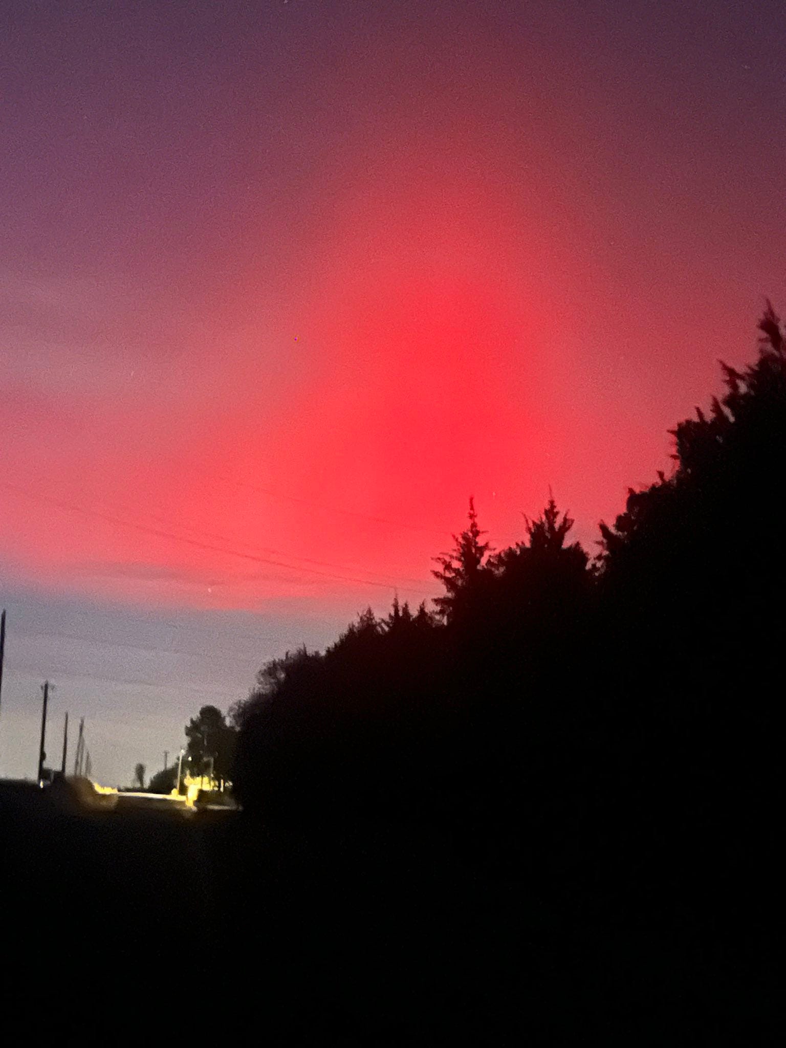
Last night was a bucket list event for me as far as my quest to see the beautiful aurora borealis (see pic above from rural east Norman, OK), and I am compelled to write about it today, especially given the event is still ongoing and more auroral displays (and other impacts) are possible today. I will do my best to explain things, and if and where I slip, hopefully I will get one of the incredible people who read this Substack to correct me. I have inserted many links to more information and definitions of various terms from NOAA and NASA, and I encourage you to visit these sites to learn more.
Per NOAA’s Space Weather Prediction Center (SWPC), aurora (borealis in the Northern Hemisphere and australis in the Southern Hemisphere) is…
the result of electrons colliding with the upper reaches of Earth’s atmosphere…The accelerated electrons follow the magnetic field of Earth down to the Polar Regions where they collide with oxygen and nitrogen atoms and molecules in Earth’s upper atmosphere. In these collisions, the electrons transfer their energy to the atmosphere thus exciting the atoms and molecules to higher energy states. When they relax back down to lower energy states, they release their energy in the form of light. This is similar to how a neon light works. The aurora typically forms 80 to 500 km above Earth’s surface.
When space weather is more active and geomagnetic storms occur, the aurora is more energized and extends equatorword, allowing it to be seen at lower latitudes than “normal” situations when the aurora is typically confined to polar regions. Space weather “refers to variations in the space environment between the sun and Earth (and throughout the solar system) that can affect technologies in space and on Earth. Space weather is primarily driven by solar storm phenomenon that include coronal mass ejections, solar flares, solar particle events and solar wind. These phenomena can occur in various regions on the sun’s surface, but only Earth directed solar storms are potential drivers of space weather events on Earth.”

Space weather is more active when the sun is in the active phase of the 11-year solar cycle. The graph above from SWPC shows how the solar cycle reached its peak several months ago, but obviously solar activity (e.g., sunspots and coronal mass ejections (CMEs)) remains very high.
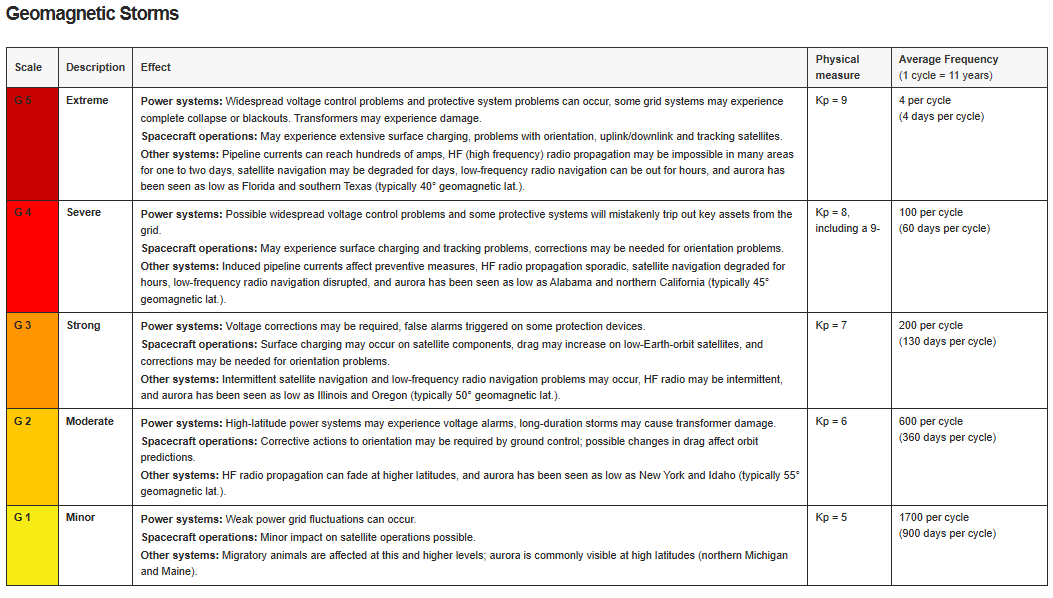
The very active space weather we are experiencing currently is the result of a series of coronal mass ejections over the last few days (click here for a very cool visual view of the CMEs from NASA and the European Space Administration’s Solar and Heliospheric Observatory). Geomagnetic storms are the resulting disturbance in Earth’s magnetic fields caused by these solar events, and they are measured on the G-scale of 1 to 5 using the observed Planetary K-index as shown above.
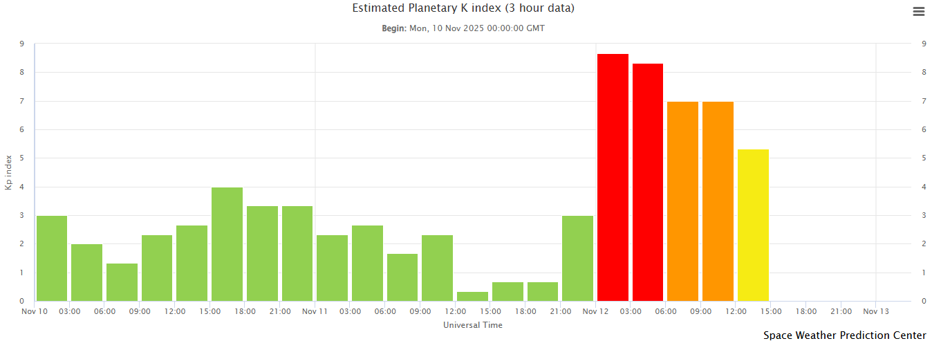
As this graph of observed K-index shows, the K-index peaked just shy of 9 last evening during the aurora display, indicative of a level G4 storm.
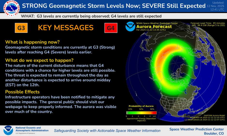
NOAA’s Space Weather Prediction Center (SWPC) is responsible for observing, forecasting and issuing United States warnings for space weather events. In their latest forecast issuance, they note that G3 storm conditions are currently being observed, but another CME produced disturbance is expected to arrive today and depending on how it interacts with Earth, G4 conditions are possible again later today or tonight.
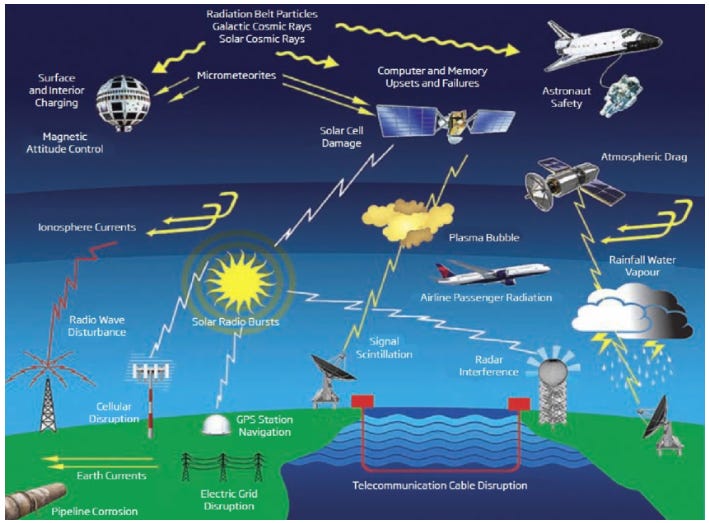
Of course, aurora is a positive impact of these solar events and geomagnetic storms, but there are many potential negative impacts as well as the graphic above shows. Interference with communication systems and GPS are commonly observed in stronger geomagnetic storms, and even more catastrophic impacts are possible from intense G5 level events. During a G5 level event in March 1989, a massive power outage occurred in Quebec due to power grid disruptions caused by the geomagnetic storm. These types of impacts are why the forecast and warning work that SWPC does is so important to our society.

Turning back to the more “fun” topic of aurora, if the intensification to G4 storm levels does occur aurora could be visible much farther south than normal again tonight. While this solar maximum has provided several opportunities to view aurora at lower latitudes — mainly using the more sensitive “eyes” of our cell phone cameras —the display last night was by all accounts the most impressive of the cycle, at least for North America. I never envisioned being able to so clearly see shimmering, moving red auroral displays as far south as central Oklahoma like my wife and I were able to watch last night. It was so visible we were even able to take a selfie with aurora in the background — literal peak life moment for me.
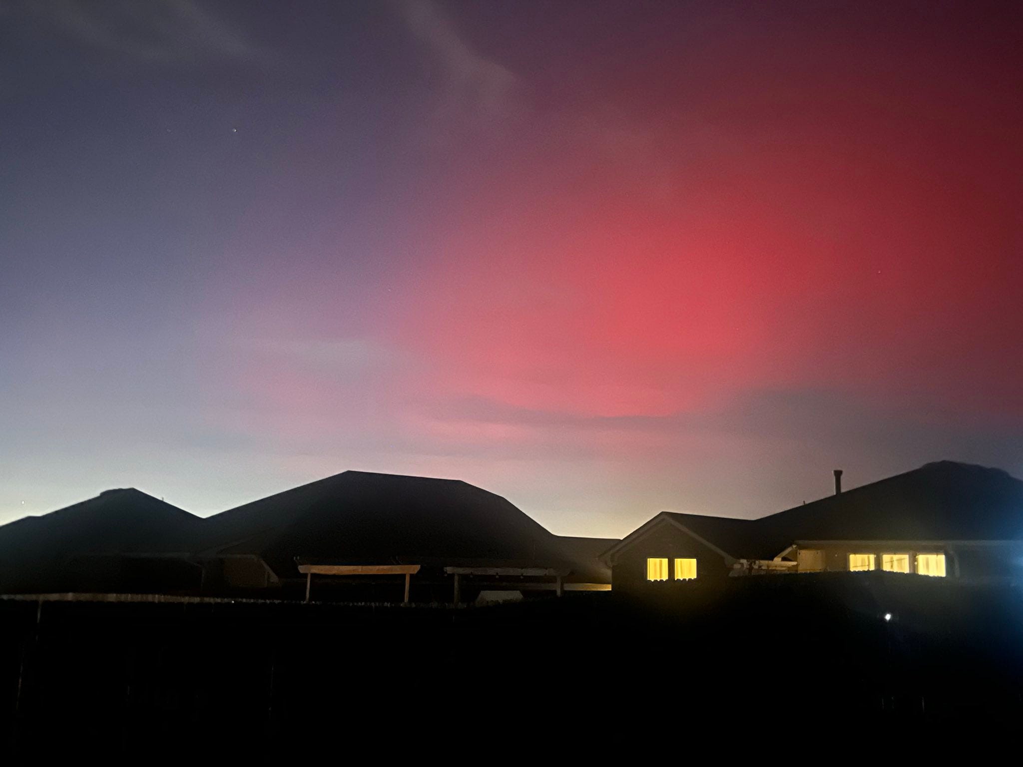
While we went out into a darker, rural area east of Norman to get a really excellent view, last night’s display was so impressive that even this far south it was visible to the naked eye even in suburban (and some urban) areas with light pollution, as my picture from about 9:30 pm CT last night shows. It was visible as far south as Florida.

Most of the pictures last night show that red coloration dominated the auroral displays. This graphic about auroral colors posted last night by broadcast meteorologist Eric Fisher shows how reds are generally only visible during intense solar activity. If you are interested in seeing aurora tonight, I urge you to follow the social media channels of SWPC and the Aurora Bot on BlueSky for the latest information.
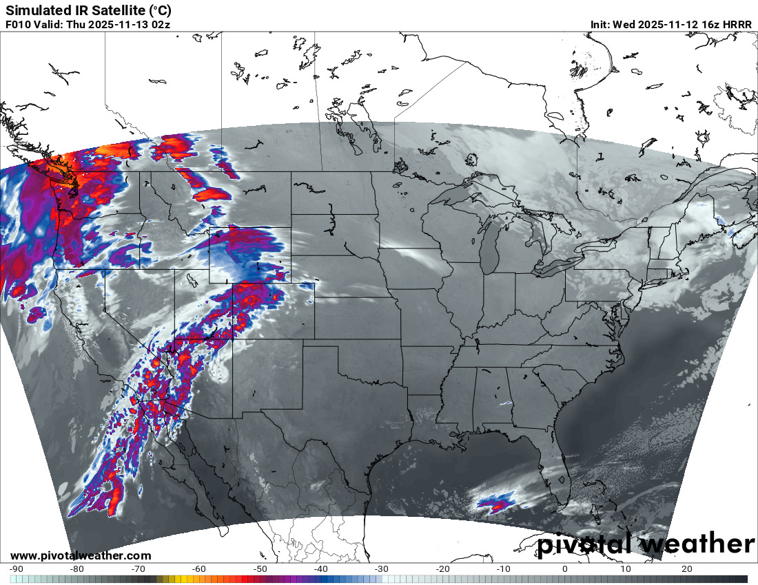
The forecast satellite picture for 8 pm CT this evening shows that cloud conditions for aurora viewing this evening should be generally favorable for much of the central and eastern United States, except the Northeast where low clouds are anticipated. Clouds and precipitation will make for much more challenging viewing conditions in the western United States.
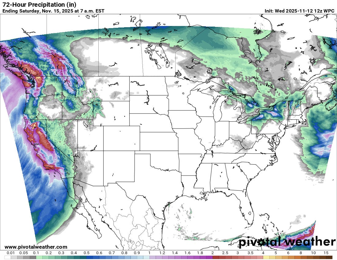
The West will be the main focus for precipitation the next few days, as a series of storm systems brings rain, thunderstorms and heavy mountain snows to the region. Winter storm warnings and winter weather advisories are in effect for the Sierra Nevada, and some localized flash flooding is possible across parts of California the next few days. Overall, though, this precipitation will mostly be beneficial from a drought perspective.
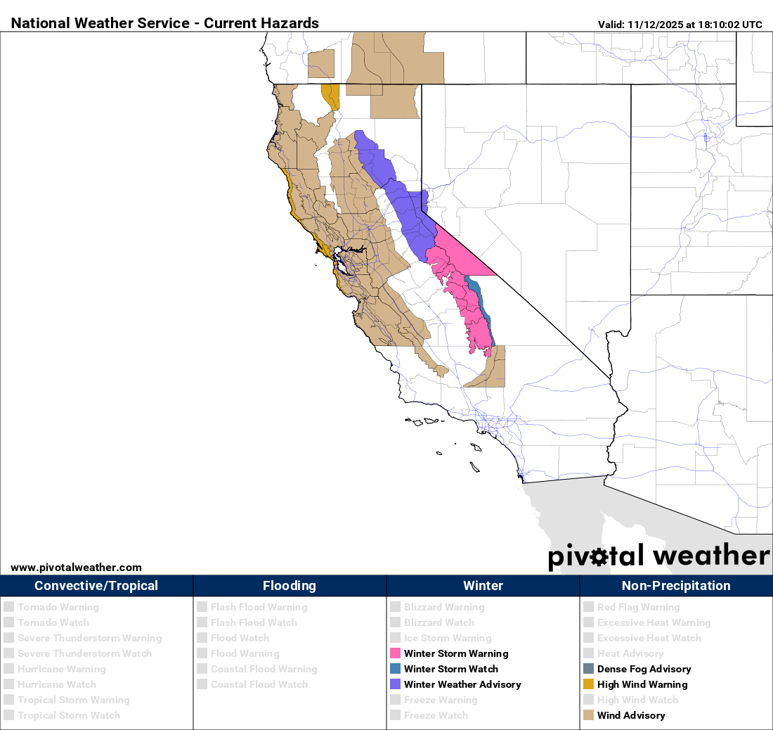
Strong winds are expected across parts of California and Oregon tonight as a low pressure system moves onshore; wind advisories are in effect for many areas (above), with high wind warnings along the coast from the Bay Area to north of Fort Bragg.
Note: The US weather community relies on the work of NOAA scientists who are exempt from the ongoing federal furlough due to the life-saving nature of their work. These federal employees are in their 43rd day of working without pay and without knowing when they will eventually receive pay. The Senate has approved a bill which, if approved by the House and signed by the President, would end the shutdown and return federal employees to work, potentially as soon as late this week. Read more here.

Leave a reply to underswansea Cancel reply