And taking a look at how unusual the severe weather over the upper Midwest over the last week has been
Apr 20, 2026
Starting off this week with a note of good news from the federal science world. As I highlighted in a post earlier this month, the University of Colorado had warned that work performed by scientists at its Cooperative Institute for Research in the Earth Sciences (CIRES) for the NOAA Global Monitoring Lab (GML) in Boulder would be halted in May due to a lapse in federal funding from NOAA. However, late last week the university rescinded the pending furlough notices for the 42 CIRES scientists performing work for GML as the $4M in grant funding was finally released, meaning their work on atmospheric and climate monitoring and observing can continue.
While there is obviously a lot of negativity permeating the national scientific community these days, I think it is very important to recognize when a potential cut is rescinded. My sense is that part of the strategy of the current administration is to announce a lot of major budget and staffing cuts — and then see which ones get a lot of pushback and which ones do not. In such an environment, it is more important than ever for groups like the atmospheric science community to be vocal with their concerns.
One particular point in this story about the CIRES furlough rescissions I wanted to highlight was CIRES Director Waleed Abdalati telling the Boulder Reporting Lab that “in the past, if federal funding lagged, the university trusted ‘that the government was good for it’ and could cover staff costs until funding came in to reimburse the university. ‘But given the current funding environment, that’s a risk that we just can’t take,’ he told Boulder Reporting Lab in early April.”
As someone who personally has a lot of experience from the federal side in working through these scientific grants to universities, I cannot stress just how important I find this observation by Director Abdalati. While the delays in processing federal science grants we are seeing today are way beyond what was common in the past — and in fact seem to be a strategy by administration budget officials to curtail spending — “normal” bureaucratic delays in getting federal money to universities doing scientific work for the government is certainly nothing new.
In my own experience, these delays occasionally got to the point where project funding was actually about to run out. However, just as Director Abdalati explains, in all of those situations the university was able to keep scientists employed and working based on assurances from their federal partners that the money was “on the way.” I do not believe there is any way in the current environment that university officials could continue that practice given the clear messaging by the current administration about aggressive cuts to scientific budgets — and of course the fact that the administration is actually allowing funding to lapse for a number of projects. These are the sort of issues that will complicate the administrative processes of federally supported science going forward even if and when budgets return to more stable levels.

After a very busy week last week, the weather this week is starting off much quieter. A storm system moving into the West Coast will bring rain, thunderstorms, and some high elevation snow to the Pacific Northwest and California the next couple of days. While the precipitation is of course very welcome for much of this area, the track of this weather system is such that it will bring limited precipitation to areas from the Southwest into the central Rockies that most desperately need it given ongoing extreme drought. Showers and storms will bring some much needed moderate rainfall to parts of Texas.

Last week was very active for severe weather, with nearly 2200 reports of severe weather received, culminating in the severe weather outbreak on Friday (graphic above) that produced a number of significant tornadoes across the upper Midwest, widespread damaging winds and embedded tornadoes across the mid-Mississippi Valley, and hundreds of reports of large hail all across the central U.S.
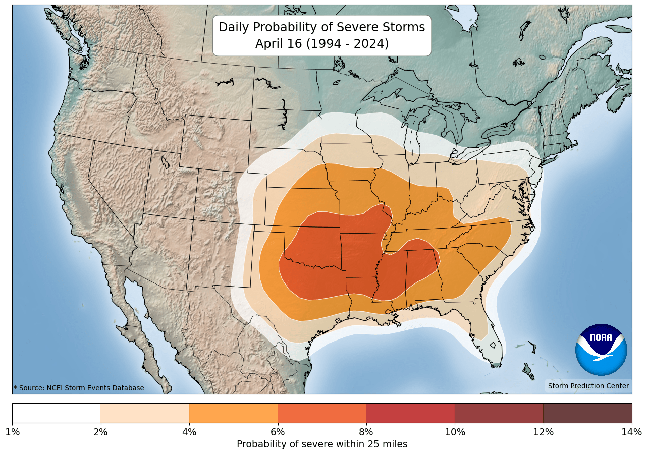
The biggest focus for severe weather much of last week was in the upper Midwest, which is very unusual for this early in the year. As this graphic shows, the daily climatological probability of severe weather for mid-April is focused much farther south (data available from Storm Prediction Center).
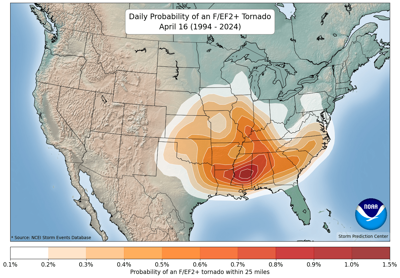
The probability of significant tornadoes is even more dramatically focused much farther south at this time of year, primarily along the Interstate 20 corridor and parts of the lower Ohio Valley.
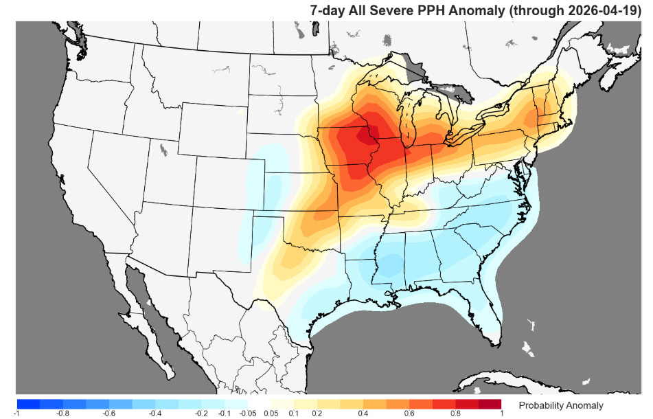
The National Severe Storms Lab and Storm Prediction Center have a wonderful severe weather monitoring page that enables examining all sorts of trends in recent severe weather reports, including how recent reports compare to “normal.” This graphic shows just how unusual the severe weather over the last week in the upper Midwest was compared to normal. Below normal severe weather activity in the Southeast is also quite apparent.
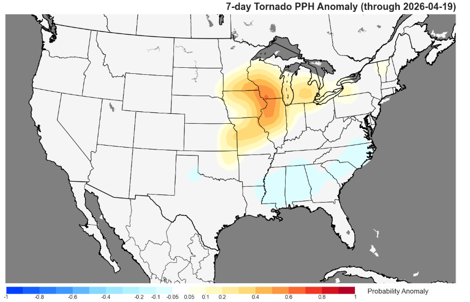
A similar trend can be seen in the tornado reports over the last week, with a maximum in above normal activity centered over southwest Wisconsin.

While this week is starting off quiet, it does look as if severe weather probabilities will ramp up later this week as the storm system moving into the West Coast the next couple of days pulls east into the Midwest. Once again it looks like the threat of severe storms will be unusually far to the north with this system, with the NCAR AI probabilities showing a large swath of rather high probabilities of severe weather on Thursday from the mid-Missouri Valley north into the upper Midwest. By next week it does seem as if the threat for severe weather may start to shift southward as a large upper level area of high pressure developing over Canada should force the jet stream farther south.

Leave a comment