Severe risk and record heat will build across central US next few days
May 14, 2026
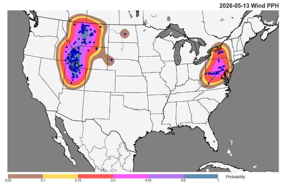
Wednesday was a surprisingly active day for severe thunderstorms in the Intermountain West, with over 250 reports of damaging winds including more than 20 reports of significant (greater than 75 mph) wind gusts. The coverage of reports and number of significant reports were more typical of an enhanced to moderate risk level event as shown in the verifying reports and probabilities above. Blowing dust from thunderstorm winds caused a five vehicle chain reaction accident near Soda Springs, ID that injured 3 people, while another similar incident injured seven on US Highway 91 along the Utah/Idaho border.
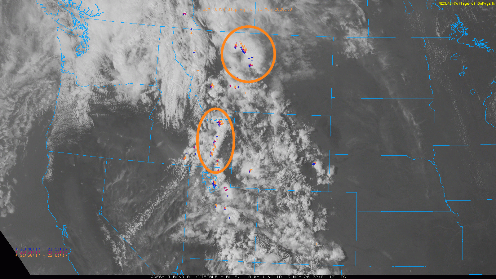
A visible satellite image with satellite detected lightning flashes overlaid from 4 pm MT does not look overly impressive, with scattered thunderstorms over much of the Rockies. There are two more organized bands of convection that I have highlighted, though — one over northern Montana and the other over southeast Idaho.

An mid-afternoon upper air sounding for Pocatello, ID derived from a 2-hour forecast from the High Resolution Rapid Refresh model shows some key meteorological aspects to why the storms in the region were so proficient in producing severe winds. First, the temperature and dewpoint trace show the classic “inverted-V” signature favorable for dry microbursts, as I talked about in a post last April.
The sounding shows sufficient instability to support high based thunderstorms, with the very dry low levels supporting evaporational cooling that will drive strong downdrafts and associated intense wind gusts when those downdrafts reach the surface. The DCAPE parameter in the lower right hand corner (blue box) is a parameter meteorologists look at to determine the potential for strong downdrafts, and the value of 1344 on this sounding is quite high.
The sounding also reveals that a strong upper level disturbance ejecting northeast through the region is providing rather strong mid-level winds, with 55 knots at 500 mb (~17,000 ft AGL). This is providing wind shear of 33 knots between the surface and the mid levels (purple box) — sufficient to help the storms loosely organize into bands of convection that could produce swaths of strong wind gusts.
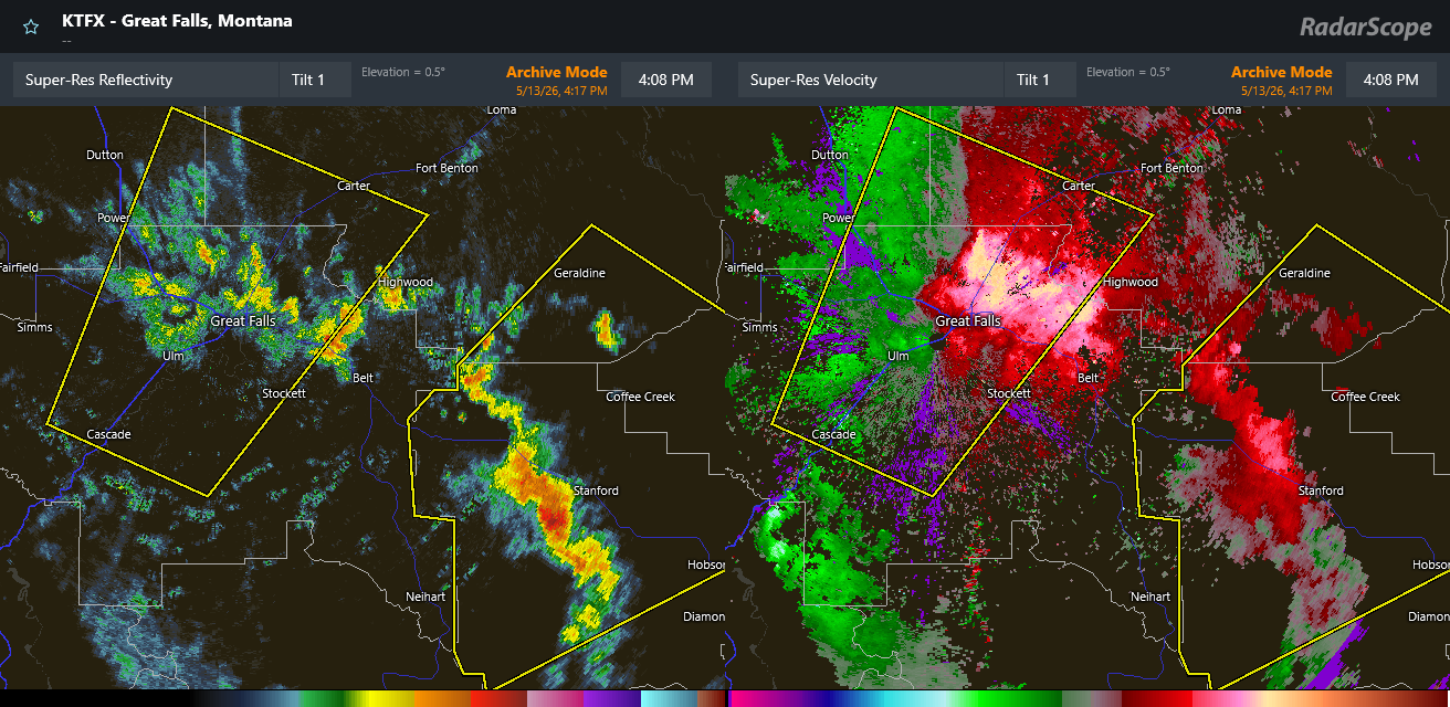
Radar data from Great Falls shows this well, with a band of scattered storms pushing through with a band of outflow winds up to 80 mph northeast of the radar, and another warned band of storms southeast of Great Falls.
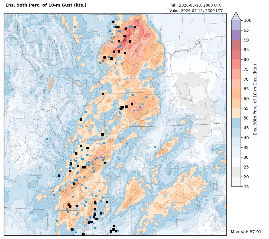
Some of our newer forecasting tools did a particularly good job with this event. The National Severe Storms Lab Warn-on-Forecast high resolution, rapidly updating modeling system was running — and it did a very good job of showing the swaths of damaging winds through Montana and southeast Idaho a few hours in advance.
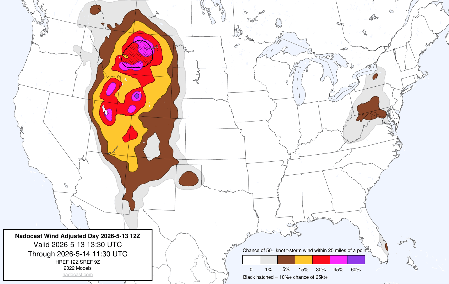
The Wednesday morning guidance from the Nadocast AI system also showed well the potential for a higher end severe wind event over the region, including highlighting potential significant winds gusts across Montana.
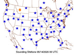
One thing I do feel compelled to point out is that Great Falls is an NWS upper air site (orange dot above), and the data from the site has been missing for many weeks, apparently since April 9th. While given the performance of tools like WoFS and Nadocast I do not think that this was a huge issue here, I do also obviously suspect the NWS meteorologists in Montana and at the Storm Prediction Center would have been helped by having access to this data.
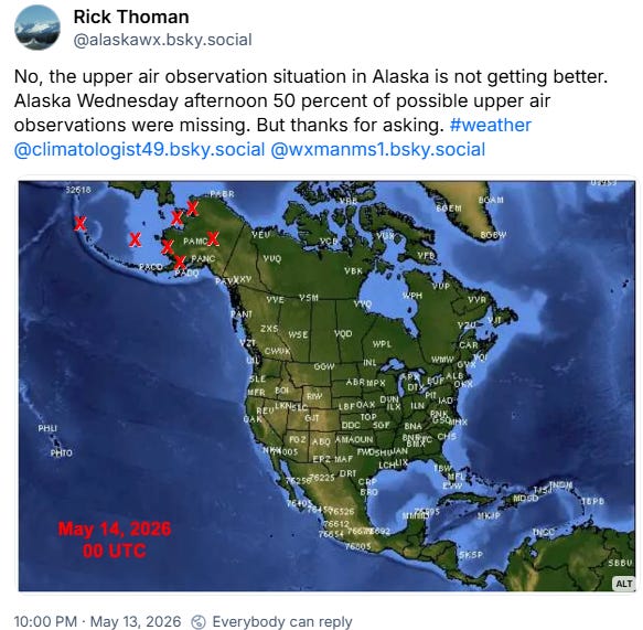
It just so happened that my retired NOAA colleague from Alaska Rick Thoman shared last night this BlueSky post highlighting that missing upper air data remains an ongoing problem in the 49th state. Not only is this an obvious issue for forecasting up there, I have had a couple of numerical weather prediction experts mention to me that missing data in Alaska could very well be particularly problematic for longer range forecasts in the US given its position upstream of us.

Speaking of forecasts, the forecast for severe weather looks increasingly active over the next several days for the central part of the country as an upper level trough of low pressure evolves in the West. While it is a little far out still for details, Sunday and especially into Monday looks to have the potential for higher end severe weather across the center of the nation as the upper level trough swings east and a strong associated surface low pressure system develops.
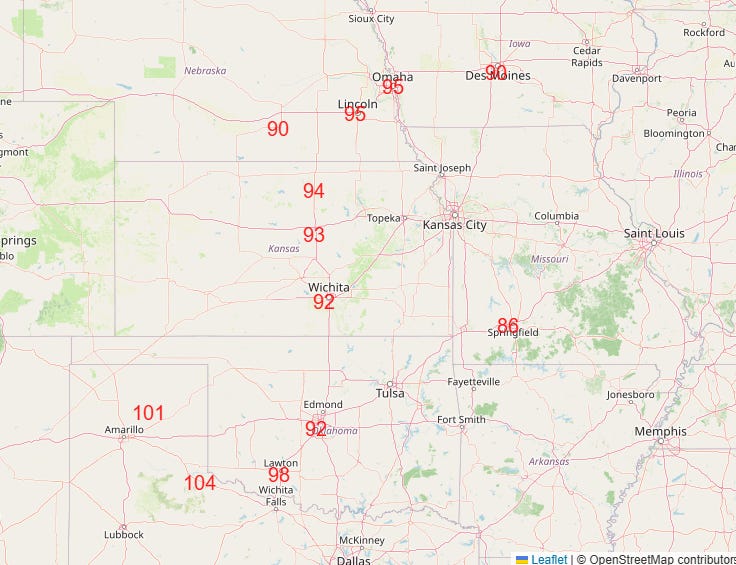
Record heat will also continue to build across the central US, with a number of record highs expected on Friday (above). This heat will continue to shift east, with numerous record warm maximum and minimum temperatures expected in the eastern US early next week.

Leave a comment