
Some relief anticipated in Southeast and parts of the West; early season heatwave builds over western Europe
May 24, 2026
Happy Sunday – going to use today’s newsletter to do an update on what’s going on climatewise nationally and globally.
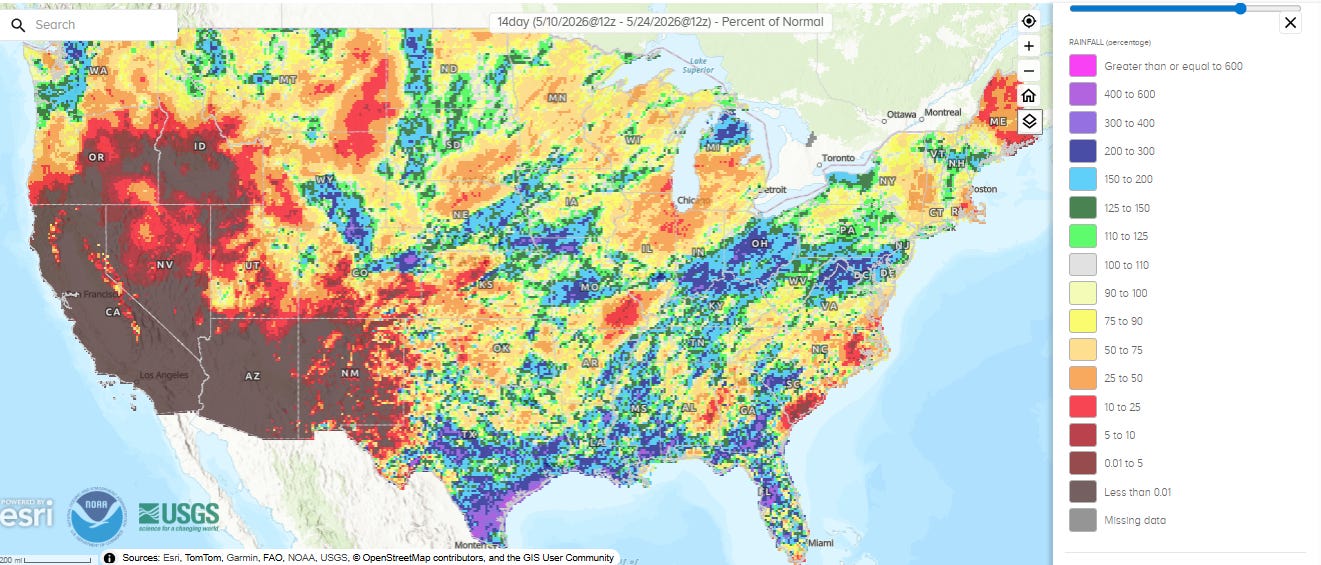
The last two weeks have finally seen some beneficial rainfall for the Gulf Coast region, with well above normal precipitation fairly common along the coastal areas and much of Florida. However, just inland the rainfall pattern becomes more inconsistent, with many areas below normal. Farther north, the Missouri Valley into the Mid-Atlantic are another area that has done well with rainfall the last two weeks, while much of the Upper Midwest has seen normal to below normal precipitation. Most of the area from the Rockies to the west has seen little if any precipitation in the last two weeks, with the exception of the Front Range of Colorado and Wyoming where locally heavy and beneficial precipitation has fallen.
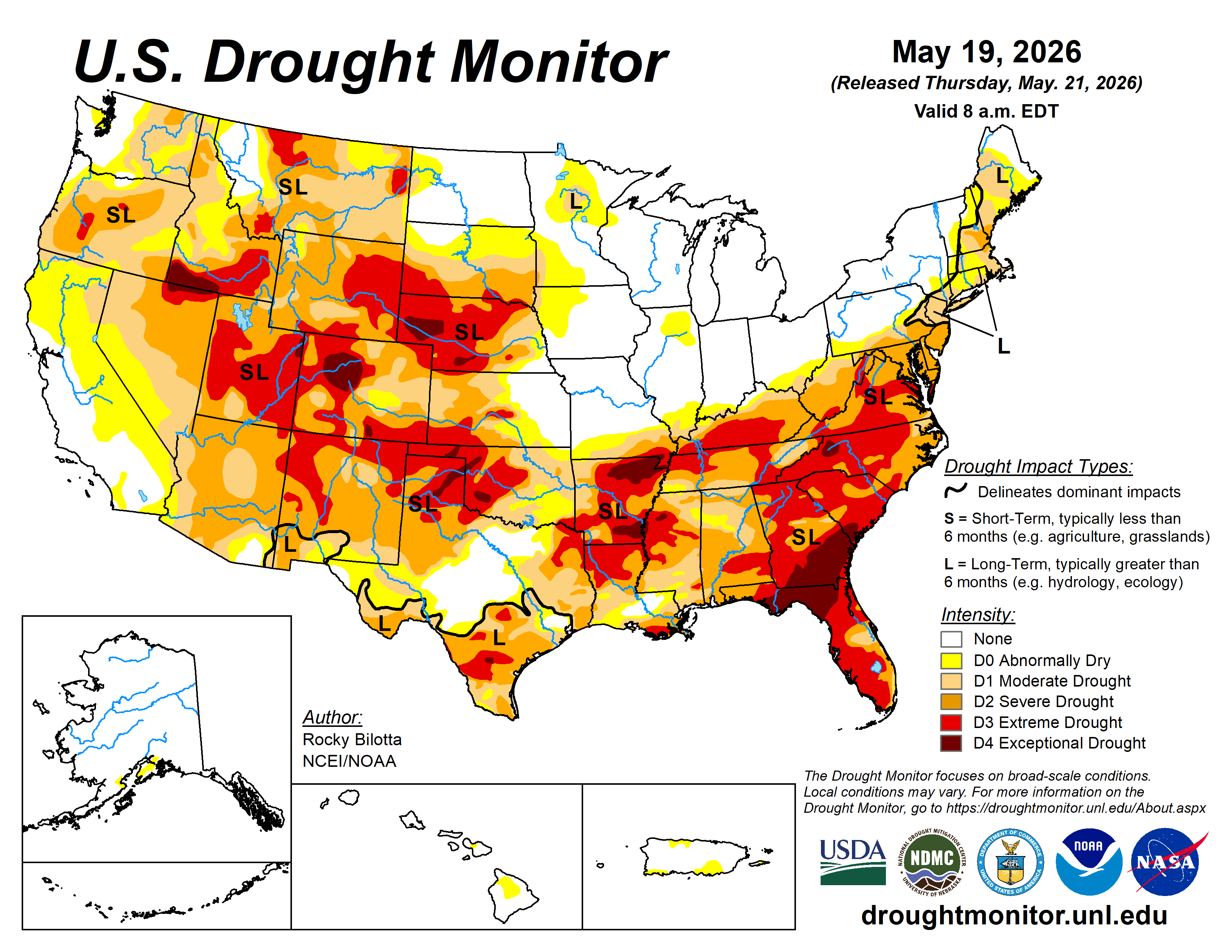
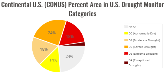
The most recent US Drought Monitor shows that the total CONUS landmass experiencing severe or greater drought has doubled in the last 3 months, going from 22% to 44%.
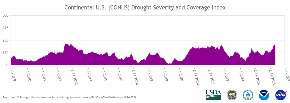
The CONUS Drought Severity and Coverage Index (DSCI) has reached 206, which is the highest level since 2012, just surpassing the peak value of 201 reached in the summer to autumn drought of 2023. The National Integrated Drought Information System (NIDIS) team recently released their latest Western snow drought update in which they noted the likelihood of critical water shortages this summer:
- Snowpack, the western U.S.’s largest non-man made reservoir, is already gone in many places. Significant hydrological drought impacts (low water supply) are already occurring and will continue through summer across much of the West. Compounding these impacts, the West continues to experience long-term drought. Drought conditions can be expected to deteriorate, and impacts to become more pronounced
- This year’s peak snowpack will be the new benchmark low for Wyoming, Utah, Colorado, and New Mexico; there are no comparable years. In these states, snow water equivalent (SWE) around April 1, the usual peak date, was 32- 53% lower than the previous record low during the SNOTEL era. In Idaho, record warm temperatures pushed snow to only the high elevations, leaving the state with no historical comparison.
- As the West enters summer, evaporative demand (thirst of the atmosphere) and water demands will increase. This will further strain and reduce water supplies. Current outlooks favor-warmer-than-normal normal temperatures. Any relief will depend on late spring storms, along with the level of activity and geographic extent of the monsoon season.
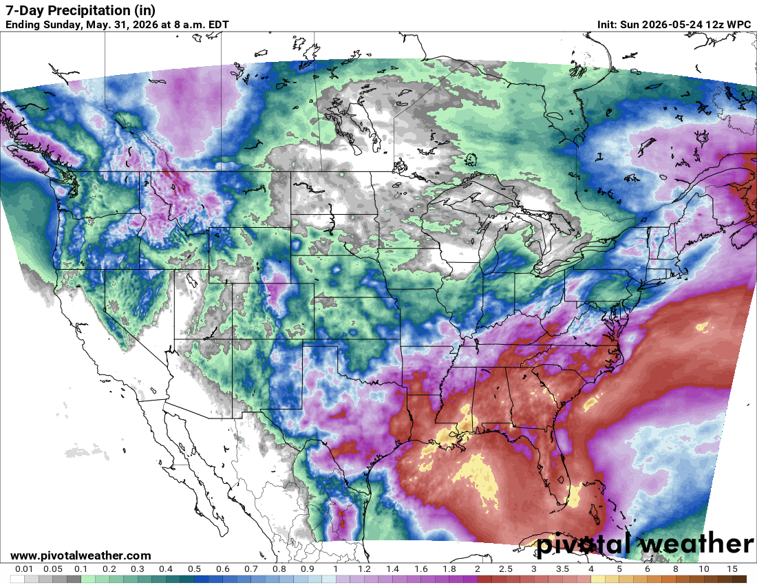
With regard to the last NIDIS bullet point, luckily the weather pattern for next week of two does look to favor some precipitation in parts of the West, as the westernmost upper level trough in the omega block pattern I discussed yesterday brings some rainfall to the region.
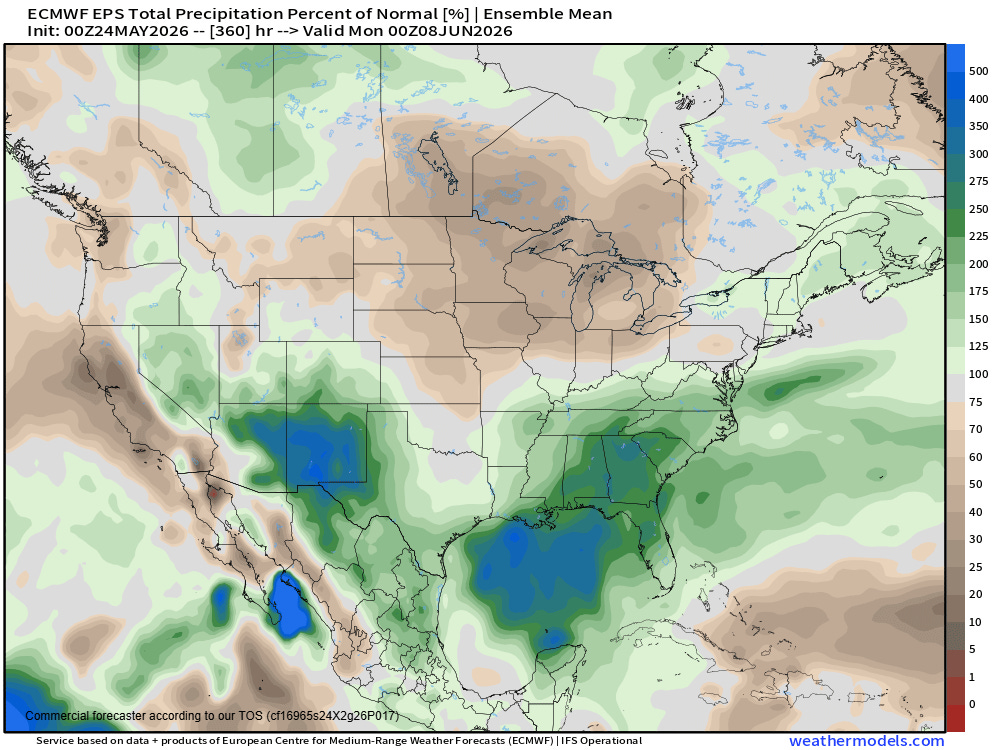
The European ensemble model two-week precipitation forecast favors beneficial above normal precipitation in the Southeast and parts of the Great Basin and Southwest. Important note, May into June is the driest part of the year in Arizona and Nevada so the actual precipitation amounts needed to get above normal precipitation is quite modest, but any rainfall at this time of year is a bonus.
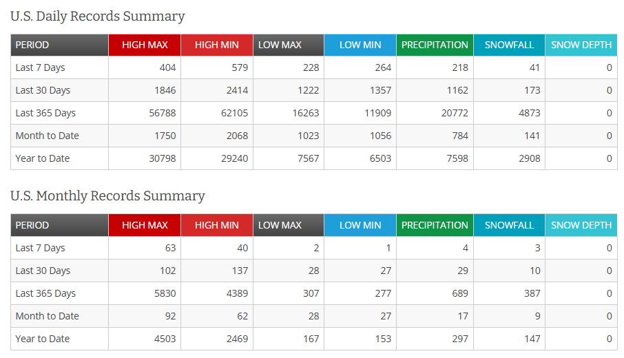
As far as temperatures are concerned, the last month or so has (as usual) seen much more frequent record warm temperatures versus cool temperatures — particularly with respect to monthly records. However, there have been a significant number of record cool temperatures as well as parts of the country have alternated between record warmth and record cold. For example, Philadelphia set their all-time May monthly maximum temperature with 98F this past Tuesday, was 95F on Wednesday — and then yesterday had a high of only 57F, just a degree above the daily coldest maximum temperature on record.
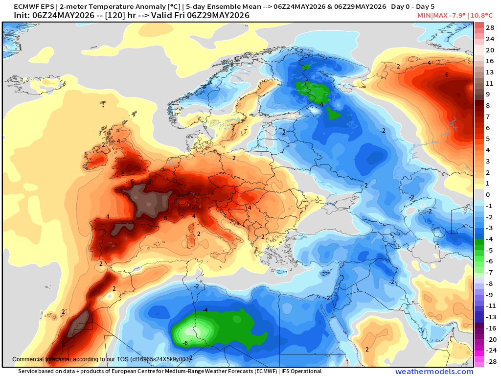
Many parts of the globe are seeing record heat, including northwest Africa and western Europe. Per climatologist M. Herrera at Extreme Temperatures Around the World, the UK saw their earliest 30C maximum temperature over 70 years on Saturday, and several locations in Spain saw their record warmest May nights on record. The record warmth is expected to continue much of this week, with some locations in Spain and France approaching and potentially exceeding 40C (104F).
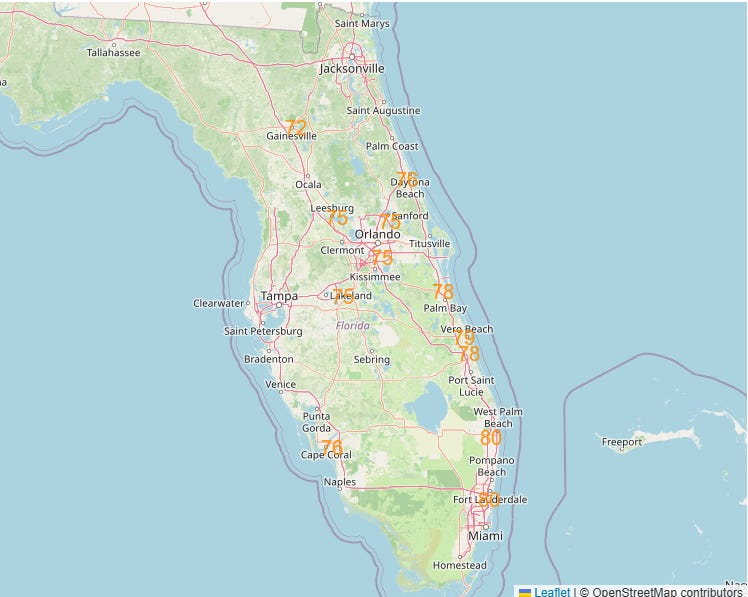
Record warm minimum temperatures are becoming more frequent in our changing climate due to the combined effects of increased temperatures and moisture, and in recent days a number of other locations around the world including in China and Central America have set May monthly warm minimum temperature records. In the US, Florida is in the midst of a string of unusually warm overnight lows, with daily record warm minimums set in the last several days at locations such as Orlando, Melbourne and West Palm Beach. Near record warm minimums are expected the next several days (NWS forecasts at or near record for Monday morning shown above).
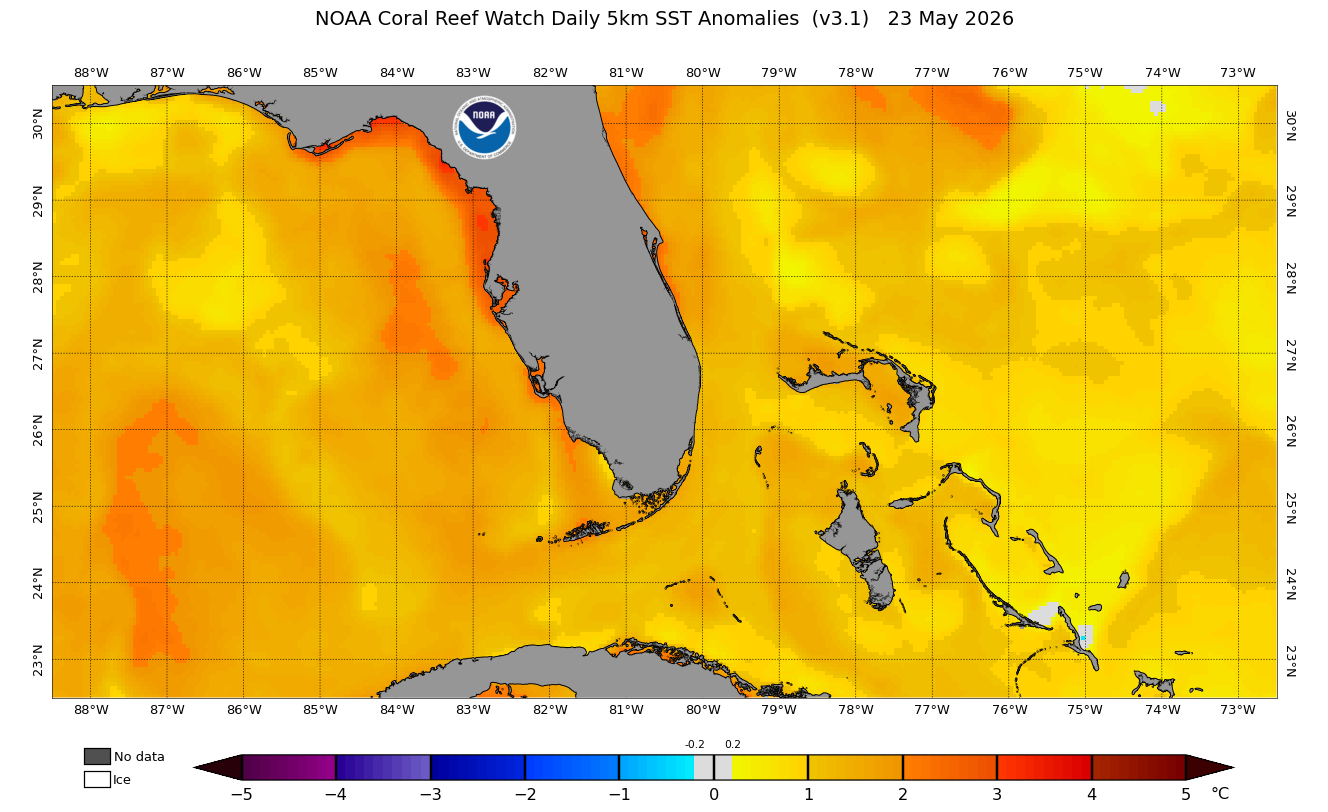
These warm minimums in Florida are likely in part due to the anomalously warm oceanic temperatures surrounding the state currently, as shown above.


Leave a Reply