
Flash flooding a concern along Gulf Coast today
May 25, 2026
I haven’t talked much about the tropics lately as they have been fairly quiet, but with the Eastern Pacific season now officially underway and the Atlantic season just a week away, I figured today was a good day to get back into the routine of using Monday’s newsletter to provide an update on the global tropics.
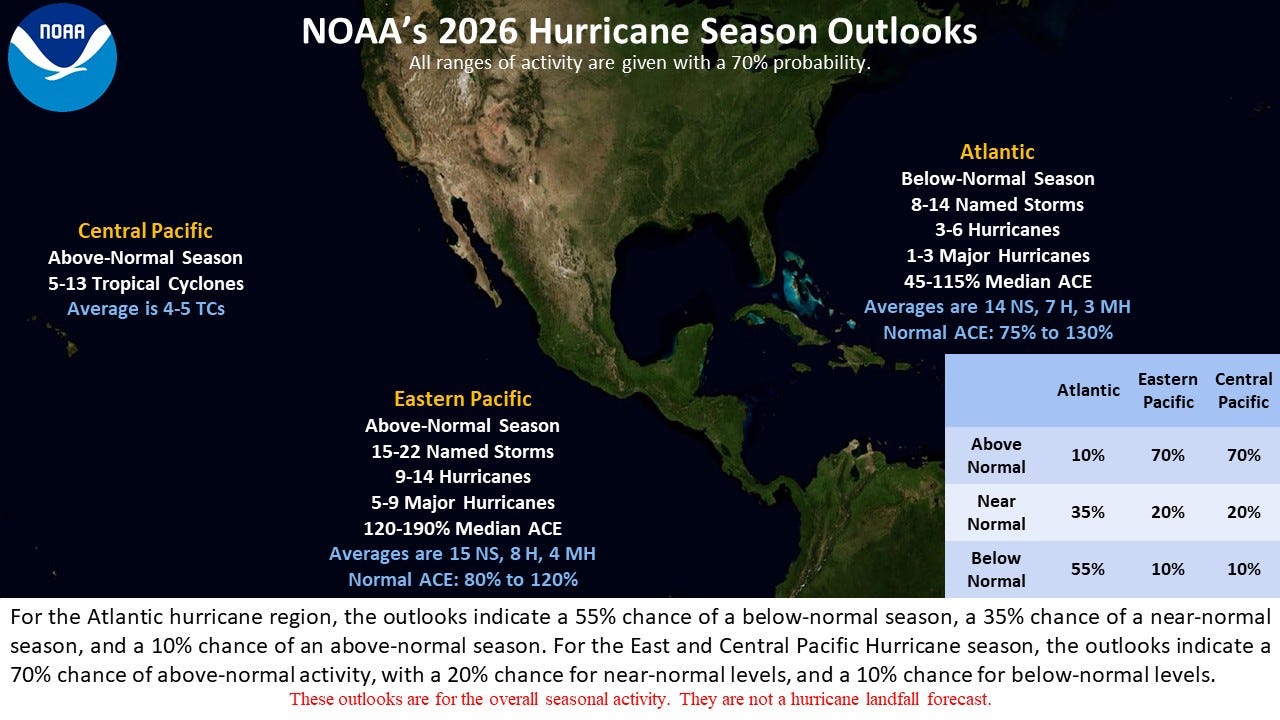
This past week, NOAA released their seasonal hurricane outlooks. For the Atlantic basin, NOAA is calling for a below normal season to be the most likely with a 55% probability of below normal activity; normal seasonal activity is 14 named storms with seven hurricanes, including three major hurricanes. Both the Eastern and Central Pacific basins are forecast to have above normal seasons, with a 70% likelihood of above normal activity.
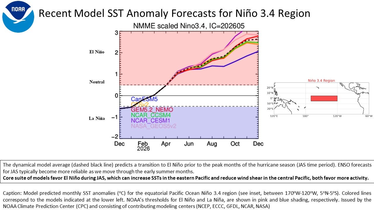
The most important driving factor for these forecasts is the anticipated evolution of an El Nino event this summer. El Nino and La Nina events cause major impacts to the global climate, and their influence on the tropics are particularly profound. With regard to hurricane season, at a basic level the increased thunderstorm activity that results from warn El Nino oceanic waters in the tropical Pacific causes enhanced upper level wind shear downstream over the Caribbean and tropical Atlantic, which typically reduces the frequency and intensity of tropical development here. Meanwhile, the shear is reduced over the eastern and central Pacific, allowing increased activity.
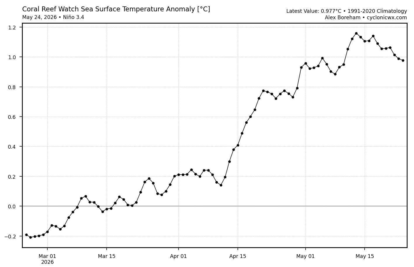
These seasonal outlooks — as with so much in the weather and climate world — come with a great deal of uncertainty, and given the importance of El Nino, the evolution of the sea surface temperatures (SSTs) in the Pacific is a key source of uncertainty. SSTs warmed dramatically the eastern and central equatorial Pacific from mid-April to mid-May and are now averaging about 1C above normal, which is already in the range for a substantial El Nino event. However, these warm anomalies will have to persist for many more weeks for an El Nino to become “official.”
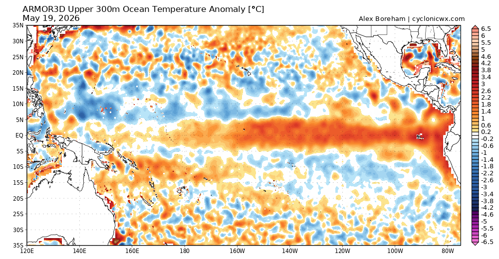
A key reason why forecasts for El Nino are so bullish heading into the summer and fall is the tremendous amount of warm water being observed under the surface all across the equatorial Pacific, suggesting that there is still plenty of upside for surface level oceanic temperatures in the coming weeks. How — and how quickly — the atmospheric circulation reacts to these changing SSTs will also be a key factor in how the hurricane season is impacted.
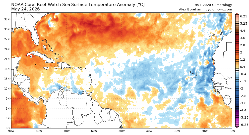
While El Nino plays a dominant role on the hurricane season, it is of course not the only factor. For example, the Atlantic basin is currently in a period in which the Main Development Region east of the Caribbean has seen above normal SSTs most years. As of now, though, SSTs are below normal in this region, which is another factor pointing toward a below normal Atlantic season.
An above normal season only increases the number and intensity of storms and associated opportunities for landfalls. While the Accumulated Cyclone Energy (ACE) totaled slightly above normal for the 2025 Atlantic hurricane season, the overall weather pattern favored the most intense storms forming well to the east of North America and recurving north before reaching land. Of the 4 major hurricanes in 2025, late-season Melissa was the only one that caused major direct impacts to land.
Along the same lines, the fact that 2026 is likely to be a below normal season certainly does not mean there will not be significant tropical impacts somewhere along the East or Gulf Coasts. Interestingly, SSTs in the Gulf and off the East Coast are currently well above normal — suggesting that any system that might form in these regions will have plenty of fuel to tap into.
I will have more to say about some of new and enhanced tools for forecasting hurricanes and their associated hazards — but one of the most promising advances in the last couple of years has been the development of the Google DeepMind (GDM) tropical cyclone forecasting system, which verification statistics last year showed was the most accurate forecast model system in the Atlantic basin.
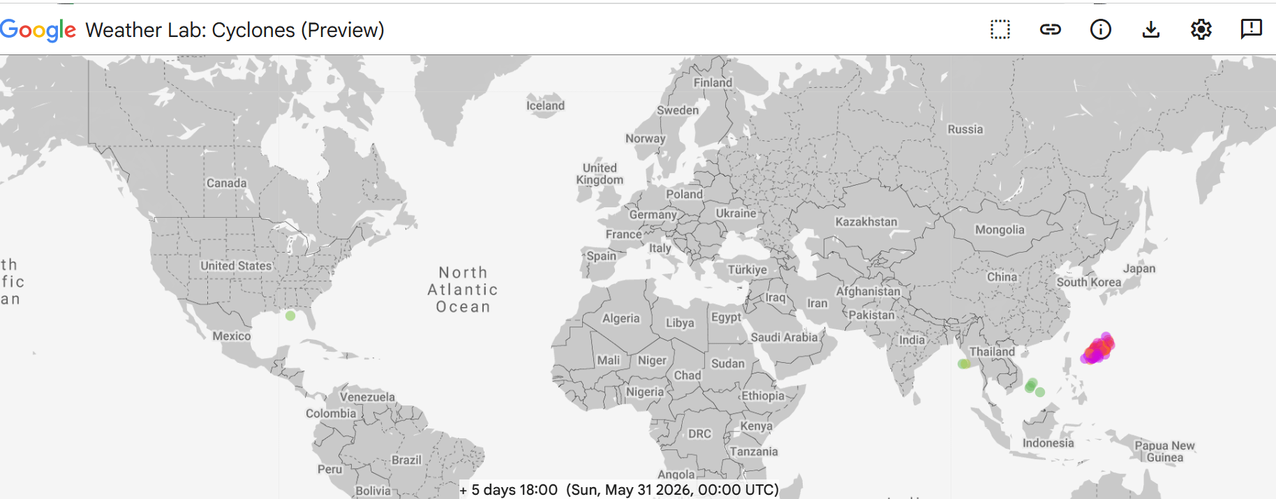
For the next several days as we head toward the “official” start of the Atlantic season, the GDM shows most of the global tropics remaining quiet with the glaring exception of the western Pacific Ocean. The western Pacific does not have a defined “season” with tropical cyclones possible at any time of year. The GDM (and other models) suggest the potential for a significant system to develop east of the Philippines over the next several days and track north-northwest. This system will obviously be closely monitored for potential impacts over the next 7-10 days, particularly for Japan as it moves in that general direction.
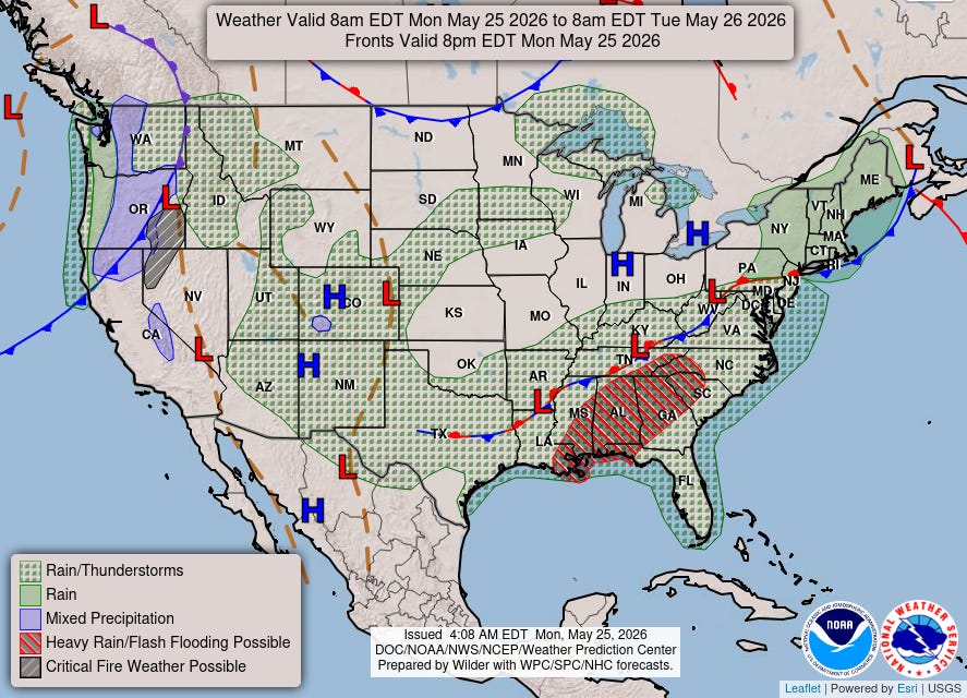
Taking a quick look at US weather as we start off the week, the main focus for impact weather will continue to be over the Gulf Coast and into the Southeast, where thunderstorms with very heavy rainfall will bring a risk for flash flooding.
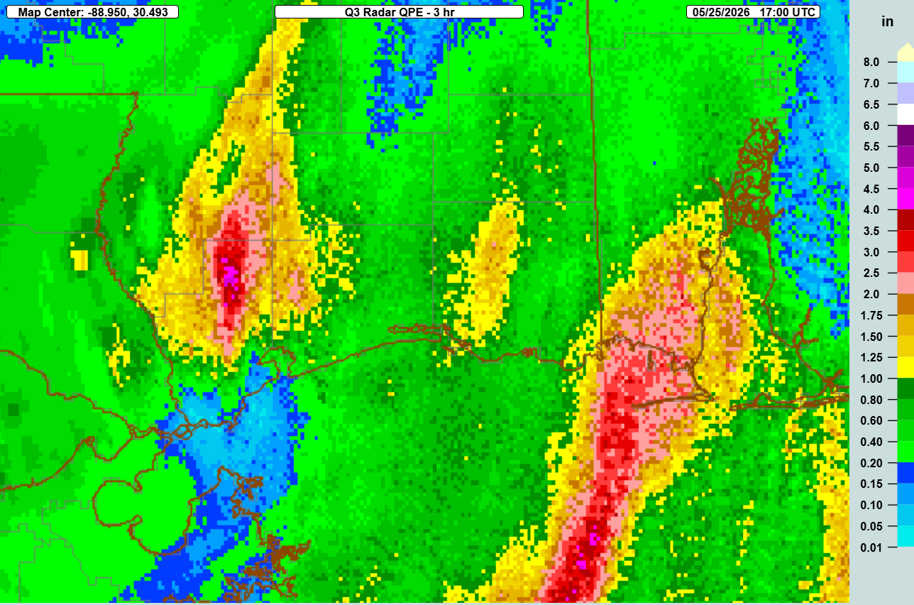
In fact, training thunderstorms have been producing very heavy rainfall along parts of the central Gulf Coast the last few hours, with 3-hourly MRMS rainfall estimates ending at Noon CT totaling nearly 5” over parts of Hancock County, MS.
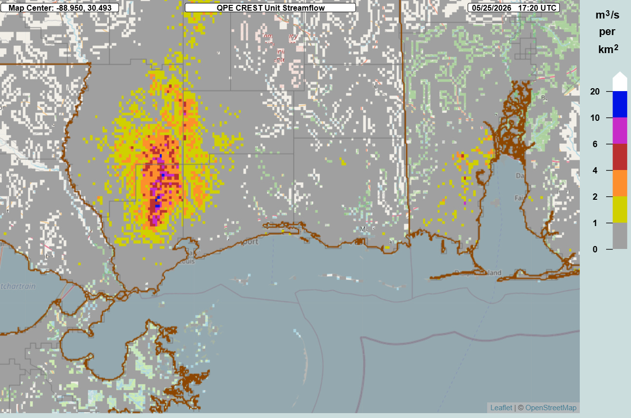
MRMS FLASH unit streamflow — a product that provides an estimate of potential inundation based on rainfall estimates and hydrologic modeling — suggests that significant flash flooding may be ongoing in parts of Hancock and Pearl River counties in Mississippi. Values greater than 10 typically are indicative of significant inundation.
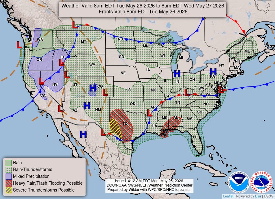
This area will have additional flash flooding risks on Tuesday, while another disturbance in the subtropical jet stream will bring a risk of thunderstorms with potential severe weather and flash flooding to parts of central and western Texas.


Leave a Reply