More severe weather expected into the weekend – and keeping an eye on the Gulf
Jun 12, 2026
Thursday into Thursday night was the latest day of extremely active severe thunderstorms across the central and eastern United States, with more than 750 reports of severe weather received by the NWS Storm Prediction Center.
As in the past few days, widespread wind damage was reported in many parts of the Midwest and Mid-Atlantic, with nearly 800,000 customers losing power at the peak of the event Thursday evening per PowerOutage.us. One person was killed in Des Moines when severe storms blew a tree onto a homeless encampment Thursday morning.
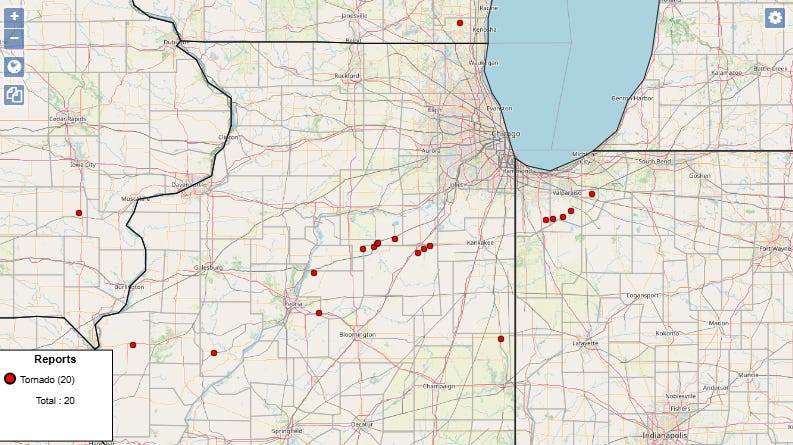
What differentiated yesterday’s event was much more significant tornado activity than in previous days, with several likely strong tornadoes occurring in parts of central and northern Illinois and northern Indiana. As supercell storms developed in western Illinois, they interacted with a northward moving boundary left over from earlier storms, which resulted in the storms have a greatly enhanced tornado potential as the moved east through Illinois and into Indiana.
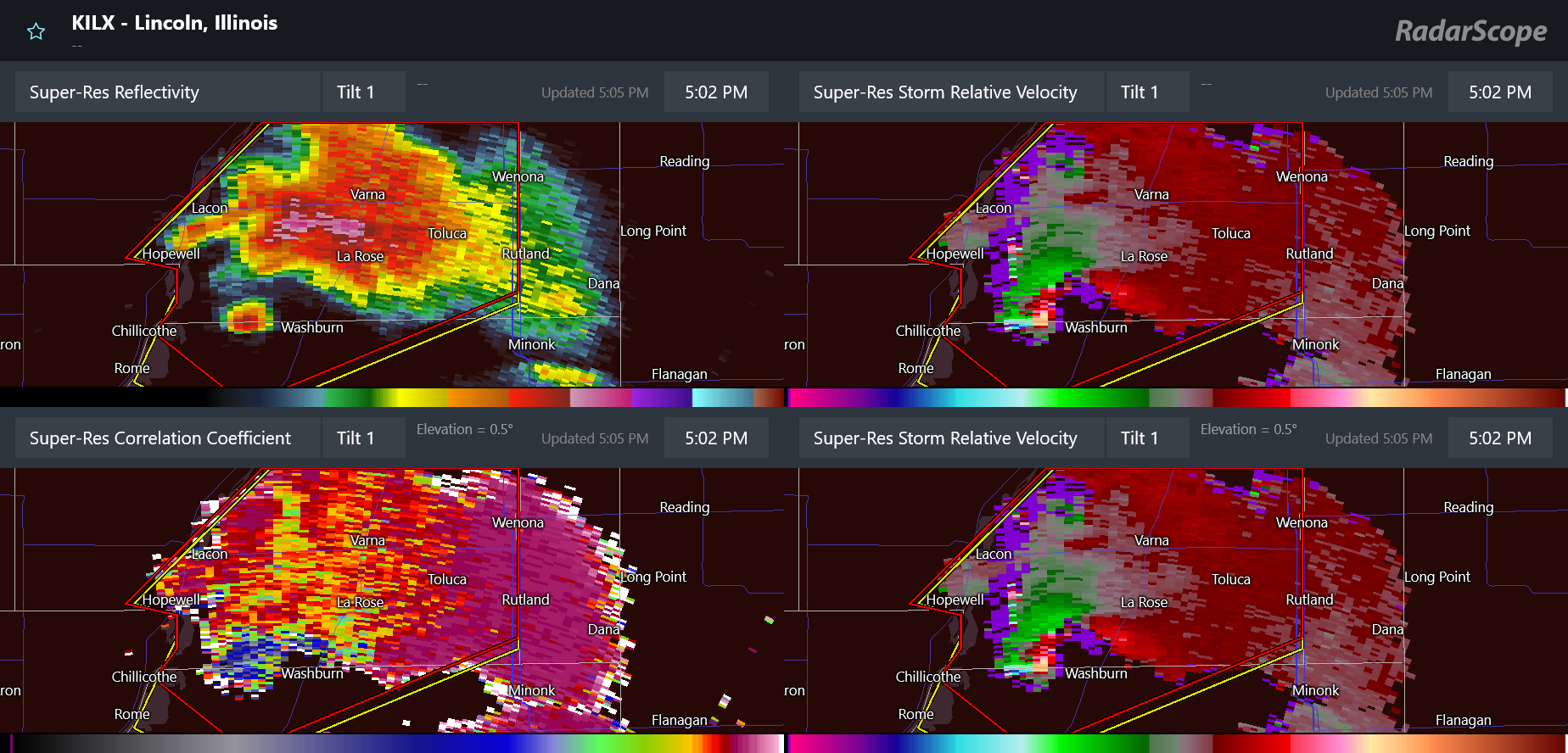
Some very impressive radar captures of tornadoes occurred in this region, including this one north-northeast of Peoria, IL. Reflectivity data (upper left) showed a classic hook like pattern – but with the debris ball actually fully detached from the rest of the storm’s reflectivity signature. The correlation coefficient data also shows the tornadic debris signature west of Washburn, collocated with intense rotation.

This is a visual of the tornado at around this time, as shared by @kentucky_wx on X and Instagram.
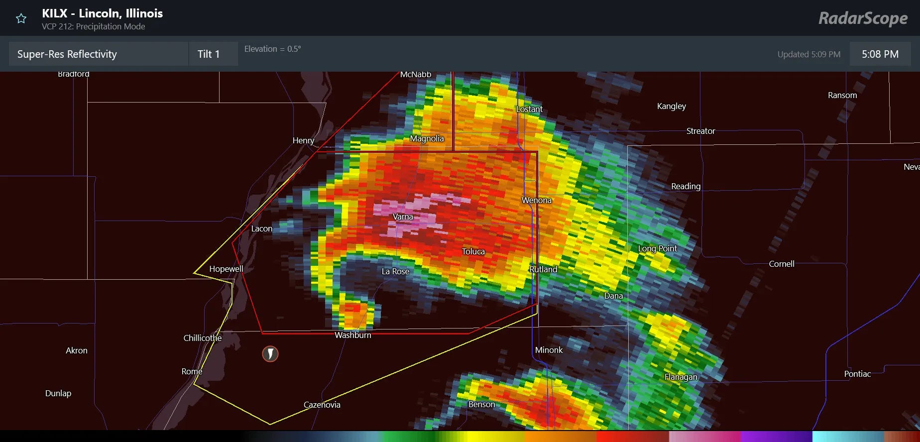
Shortly after the 4-panel above, the supercell evolved into this incredibly classic hook echo – an impressive sight anywhere, but particularly in north-central Illinois.

Today will be another active severe weather day — but a bit less so than the previous several days. The most widespread activity looks to occur along the East Coast, where scattered severe storms are expected to develop in the hot and humid airmass across the region. Damaging winds should be the main threat with these severe storms. Meanwhile, a few severe storms should also develop in upslope flow in the High Plains, with the potential for intense downburst winds and some large hail.
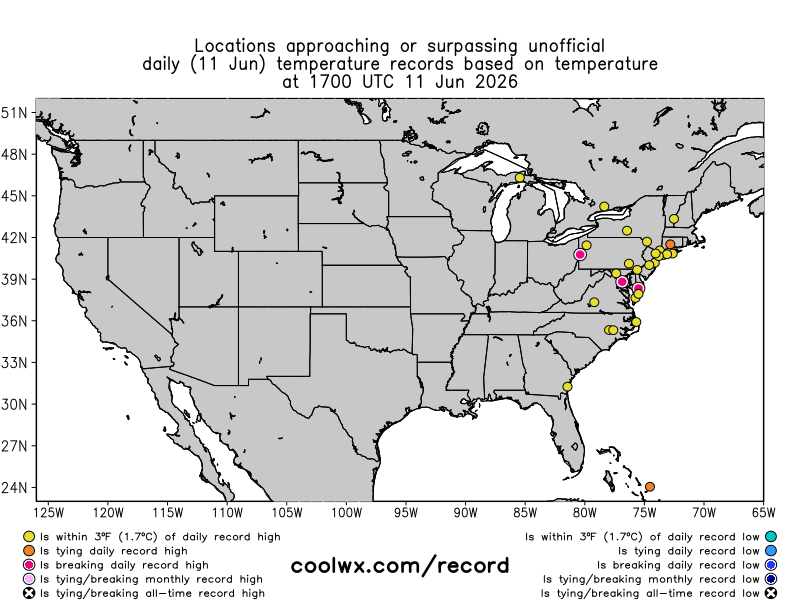
A number of record high temperatures were set along the East Coast Thursday before storms moved in — and more are anticipated today.
Record heat is expected on both coasts this weekend. That heat will continue in the West into early next week under a strong upper level area of high pressure, while the East will see a cooling trend as an upper level trough of low pressure develops over the Great Lakes region.

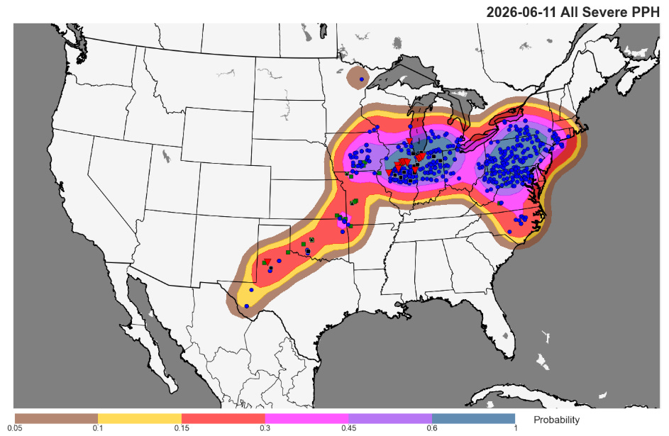
The risk of higher end severe weather will return to the central part of the country on Saturday where SPC has an enhanced (level 3 of 5) risk for eastern Kansas and much of Missouri. Severe storms during the afternoon and evening are expected to produce potentially significant damaging straight line winds, as well as the risk of large hail and a few tornadoes. By Sunday, as the cold front with the developing upper level trough moves into the hot and humid air along the East Coast, scattered severe thunderstorms are expected in the afternoon and evening with damaging winds again the main threat. After a couple of days of more suppressed severe weather activity with the upper level trough of low pressure, potential will likely build again later next week as shown in the NCAR AI severe weather probabilities above.
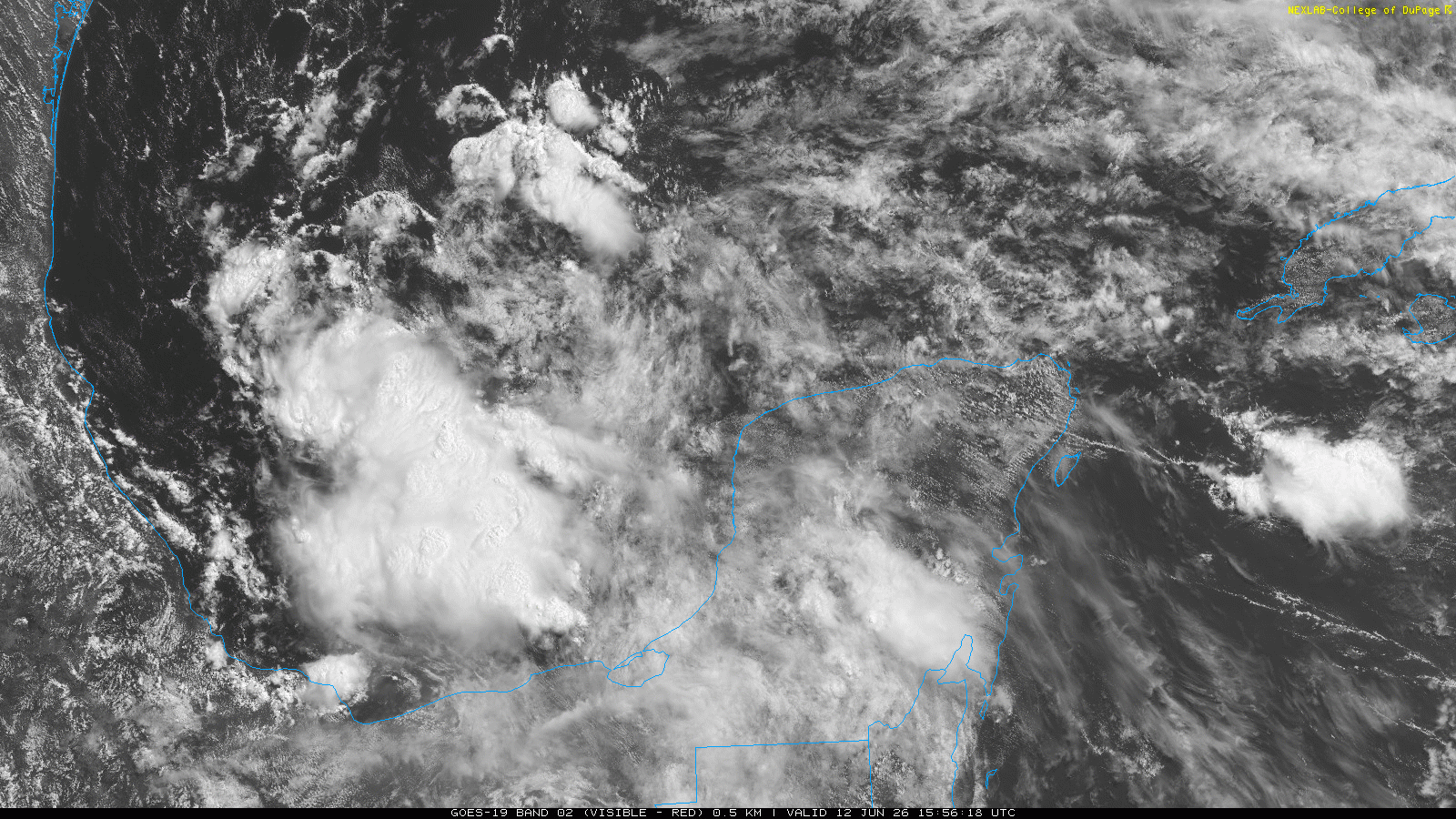
In the tropics, we continue to keep an eye on the disturbance in the southwest Gulf of Mexico, which the National Hurricane Center has marked with a low (10%) probability of development into a tropical cyclone. The system actually does not look too bad in visible imagery this morning, with decent turning apparent. However, conditions are not particularly favorable with a lot of dry air and wind shear nearby, so it seems unlikely to develop over the next couple of days as it moves northwest toward the Mexican coast.
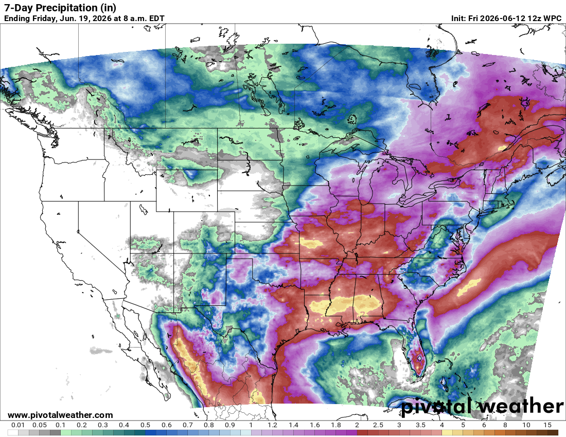
Regardless of any development, the surge of tropical moisture associated with this disturbance is expected to fuel heavy rainfall across the Gulf Coast region early next week.
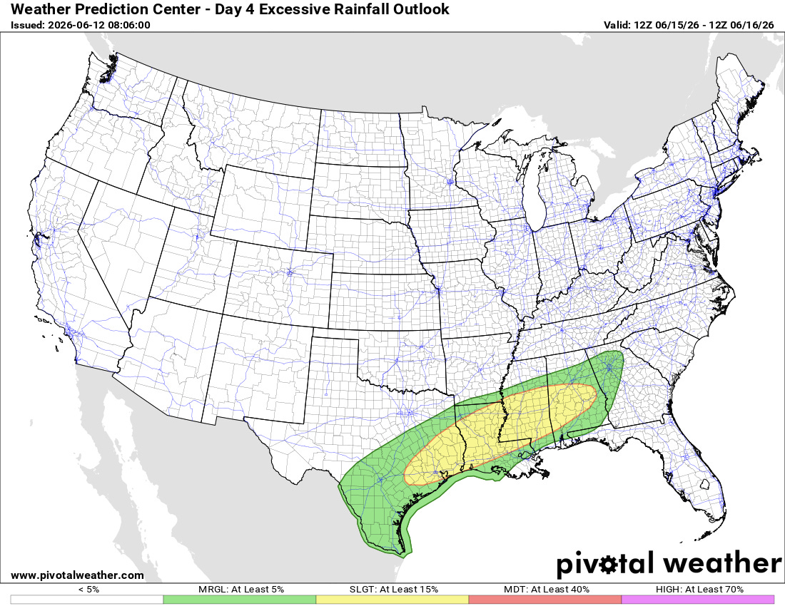
This will bring several days of potential flash flooding risk to the region(Monday Weather Prediction Center outlook shown above).
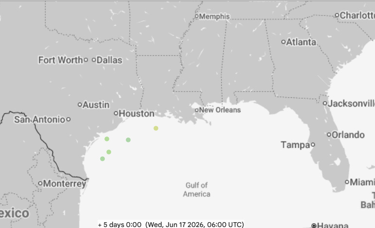
Additionally, a handful of members of the AI ensemble guidance — including the Google DeepMind (above) and European AI ensemble — have been showing a system developing over the northwest Gulf during the early to middle part of next week. This is likely due to festering thunderstorm activity with this disturbance and in the favorable region southwest of the jet stream associated with the Great Lakes upper trough. While this is a low probability evolution, it is the kind of tropical development that tends to happen in June — particularly in an El Nino — so it is worth keeping an eye on.
Programming Note: Given the increase in active weather, I have started utilizing the Substack Chat feature again to share real-time updates. I will be utilizing chat and possibly occasional live videos over the next several days — as a reminder, these are benefits that paid subscribers receive for their support of Balanced Weather. Any videos I do will also be recorded and shared to all subscribers. I also provide updates on my BlueSky and Facebook feeds, and via occasional Substack Notes.

Leave a comment