Record flooding in parts of the Great Lakes, while drought intensifies in parts of the South and West
Apr 19, 2026
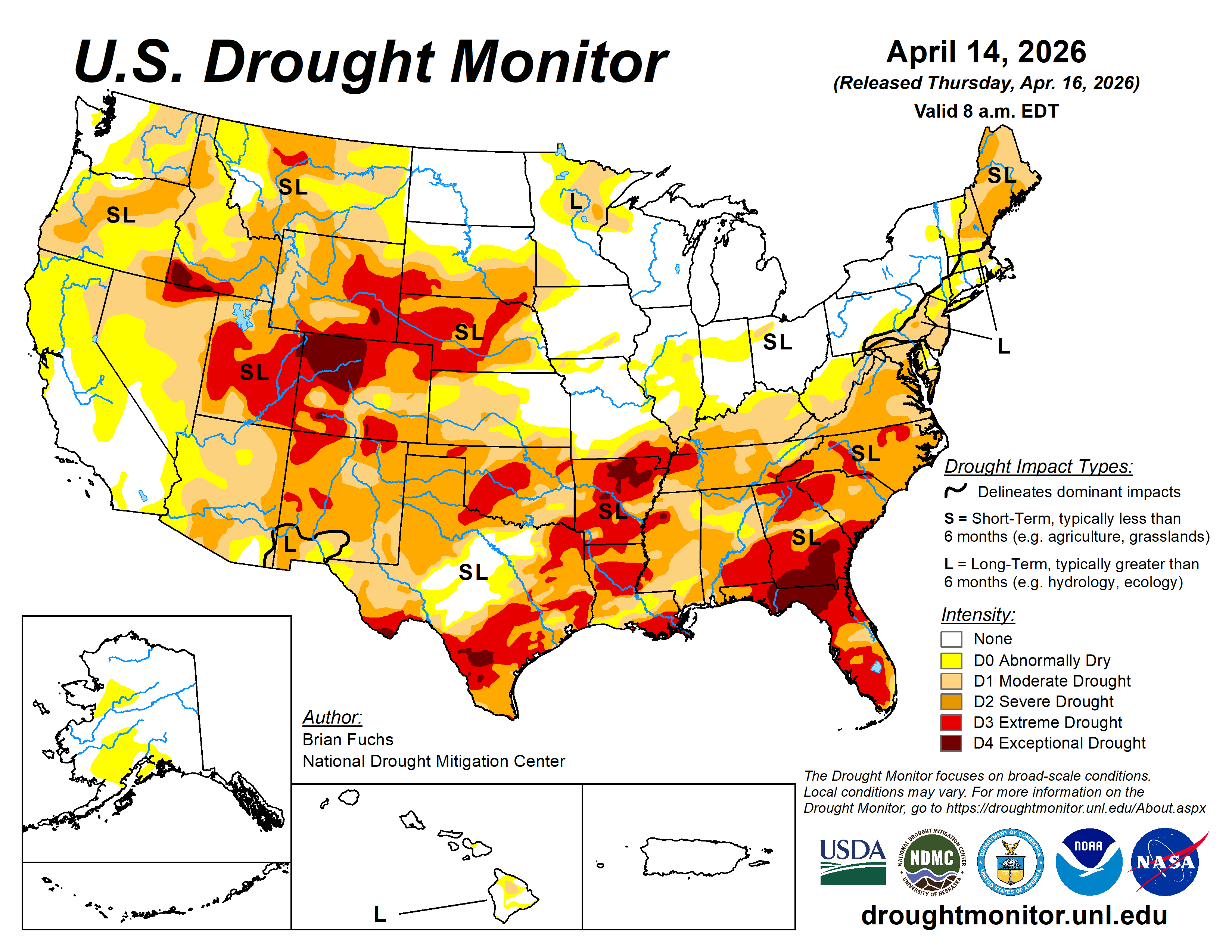
The most recent drought monitor from the USDA and NOAA was released late last week, and it showed that drought has continued to intensify across parts of the country. 15% of the country is now experiencing extreme or exceptional drought, the highest percentage since the first half of 2022. The most extreme drought is focused in three main regions of the country.
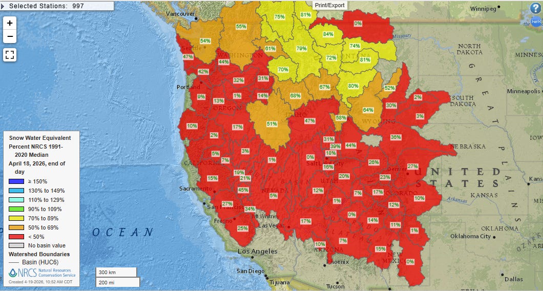
As has been extensively reported in the media in the last several weeks, snowpack is extremely poor over pretty much the entire western United States, with most areas other than the mountains of Washington and the northern Rockies seeing snow water equivalent (amount of water that would result if all snow on the ground were melted) values well below 50% of normal.
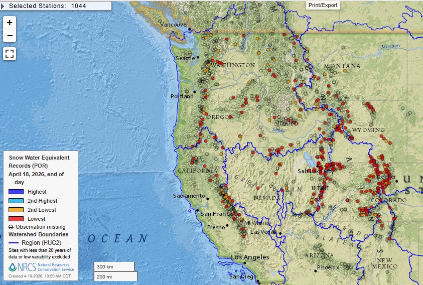
All of these stations marked with red dots observed their lowest snow water equivalent (SWE) on record for the date yesterday, with the orange dots representing the second lowest on record.
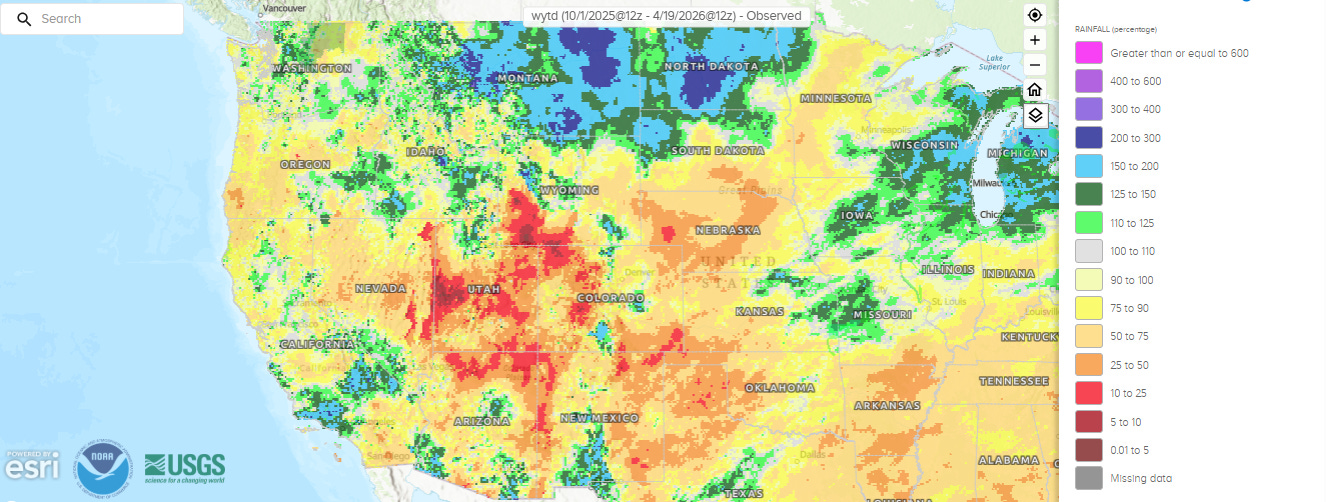
The SWE map shows a particular concentration of record low values across Utah and Colorado, and the percent of normal precipitation for the current water year (October 1 to today) shows that this region down into the area of the Four Corners has been the area that has been the driest overall for the last several months, with many areas having less than 25% of their normal rainfall. This has resulted this region being the current ground zero for drought in the West, with most areas in extreme drought and northwest Colorado in exceptional drought.
This region includes the headwaters for the Colorado River, and the drought is exacerbating an ongoing water crisis (read my colleague Matt Lanza’s excellent summary from several weeks ago here) surrounding this critical sources of water supply for much of the Southwest. Late last week, the Trump Administration announced emergency measures to try to prevent Lake Powell, the second largest reservoir in the nation, from falling to levels so low that it would not be able to produce hydroelectric power.
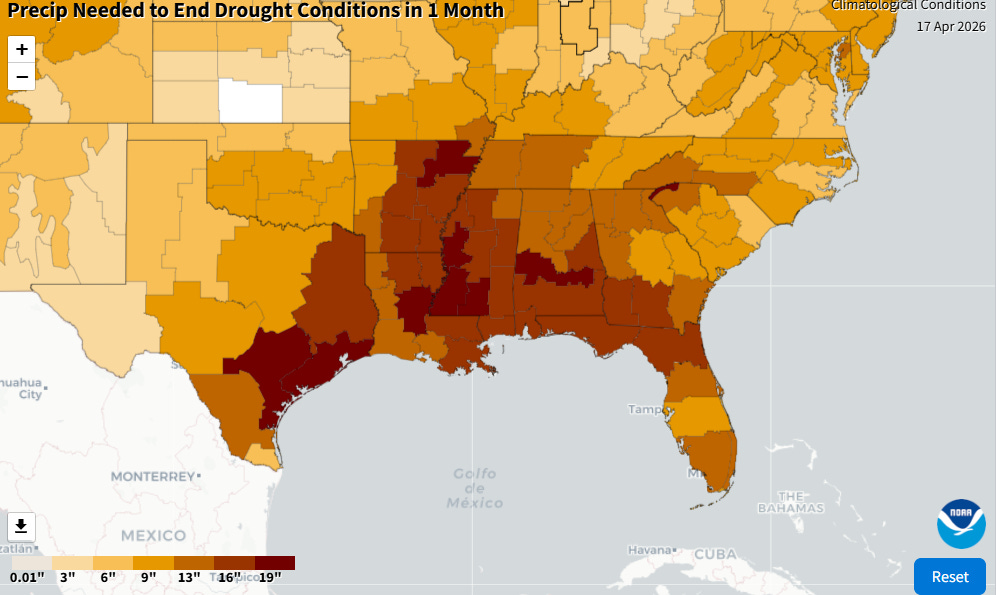
The other two areas of extreme to exceptional drought are in the South, one area running from south Texas to the Mid-South, and the other centered in northern Florida and southern Georgia. Obviously, these regions typically get much more rain than that the West, and these areas have been suffering from chronic below normal precipitation for the last year. Many areas now need more than a foot of rainfall to relieve the long term drought conditions. This has serious implications for water supply (e.g., Corpus Christi severe water crisis) and wildfire potential. Spring is the typical peak of wildfire season in Florida and surrounding areas, and there have already been significant issues with wildfires in recent weeks in the state. Dry and record warm temperatures in the last several days (Atlanta reached 90F on its earliest date on record Friday) has exacerbated the short term situation, and elevated wildfire conditions are expected across this region in the coming days.

Not a lot of relief is expected in the areas with most severe drought concerns over the upcoming week, with the exception of the area from south Texas into the Mid-South where showers and storms will provide some moderate amounts of rainfall.
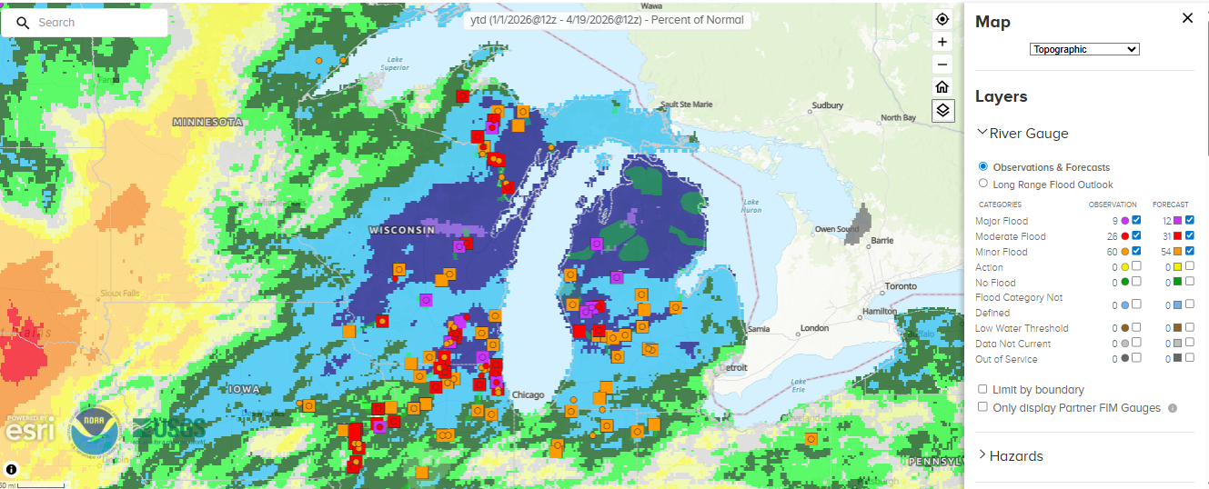
Meanwhile one of the few parts of the country that has seen above normal precipitation so far in 2026 has been the western Great Lakes region, and the issue here is definitely with too much rainfall as many rivers are in major flood.
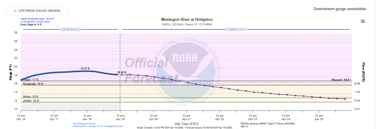
In fact, some rivers are at record levels. The Muskegon River is at record levels. The gage at Bridgeton shattered its previous record, reaching 19.27’ yesterday (records go back to at least the late 1970s).
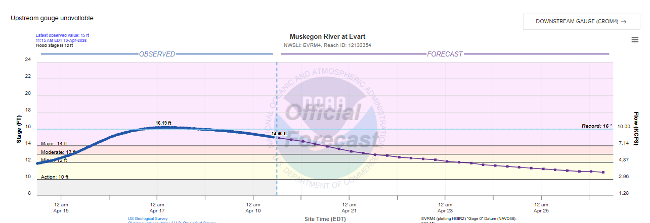
An upstream gauge at Evart also set a new record stage, and records here go back to at least the early 1930s.
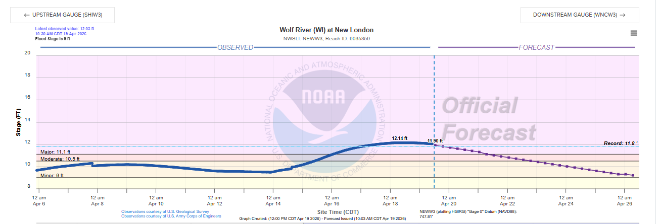
Record flooding is also occurring in parts of Wisconsin, with the Wolf River at New London reaching a record yesterday (records go back to at least the 1930s).
Needless to say, this is having major impacts to property in the region — evacuations have resulted and the governors of Wisconsin and Michigan have declared states of emergency. While the weather will not be as active for thunderstorms in this region in the upcoming week as was seen last week, more showers and storms will be possible later in the week.

Leave a comment