Colorado Front Range finally looks to get a snowstorm – now that it’s May
May 04, 2026
I want to start off today’s newsletter with a quick update on the ongoing start of the anual budget appropriations process for federal science agencies. Last week, the House Appropriations Commerce, Justice, Science (CJS) and Related Agencies Subcommittee met to consider — or “markup — it’s Fiscal Year 2027 draft bill. The CJS subcommittee has jurisdiction over a number key agencies for the meteorology community, including NOAA, NASA, and the National Science Foundation (NSF).
The subcommittee approved a bill along a party line vote that would appropriate $4.070B to NOAA for operations, research and facilities (ORF), the primary operating budget for the agency. This is well above the President’s request ($3.337B) but a cut of nearly 10% of what was appropriated for the agency in FY2026. At this point, we do not have access (at least I have not seen it yet) to the subcommittee’s bill report which will give much more detail on the subcommittee’s intent for specific agencies and projects. However, in the press release announcing the bill, Subcommittee Chair Hal Rogers (R-KY) stated that the bill was “increasing funding for the National Weather Service to protect Americans from severe weather and eliminate radar gaps.” That would obviously be good news for the NWS and meteorological operations — but given the proposed overall cut to NOAA, would likely mean large cuts to other NOAA programs including potentially NOAA Research (Office of Oceanic and Atmospheric Research) which the administration has again targeted for elimination its proposed FY2027 budget.
With regard to other science agencies, the House bill has a funding level of $6B for NASA Science, way above the $3.894B proposed by the administration but 17% below the FY26 level of $7.25B. NSF — the entity that funds the National Center for Atmospheric Research and large amounts of basic atmospheric science research — has a level of $8.75B. Again, this is more than double the $3.409B proposed by the President, but would represent a deep cut of about 26% compared to FY26.
Again, we are just at the start of the budgeting process, and more detailed budget documents from both the House and administration for the agencies discussed above are still to come. As of now, the subcommittees responsible for some other key weather related such as the US Geological Survey (USGS), Environmental Protection Agency (EPA) and Department of Energy have not released any FY2027 information. The Senate — the chamber that was much more favorable to science agencies last year and whose budget numbers ended up being closer to what was actually passed into law — has not released any FY2027 numbers. Of course, this also does not say anything about how the administration would actually spent and allocate money in FY27 — a key issue given the slow spending that has been seen in FY26.
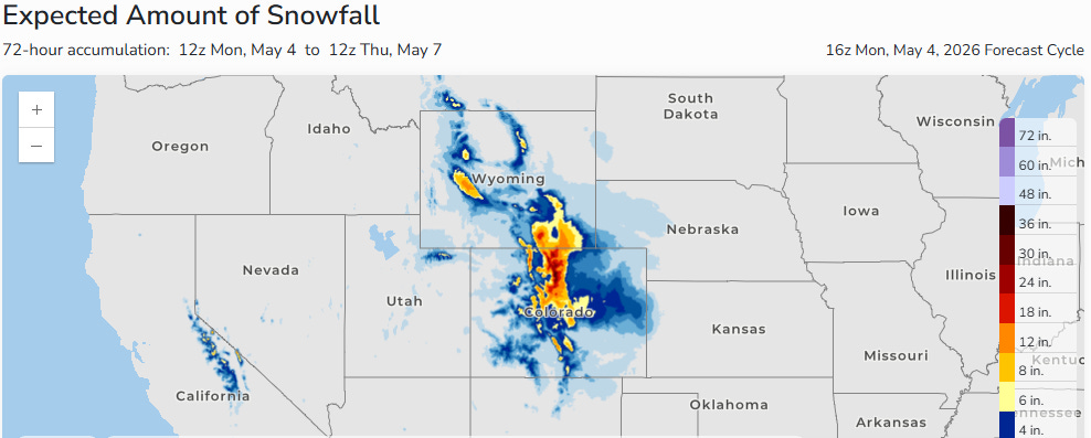
It is May — but we are not quite done talking about winter weather yet. The next in a series of upper level disturbances helping to keep an upper level trough anchored across the East will drop southeast across the Rockies and bring heavy snowfall Tuesday into Wednesday. May is the wettest month of the year for the northern Colorado and Wyoming Front Range, so getting an event like this in early May is not particularly unusual. However, it is very welcome for an area suffering from severe to exceptional drought.
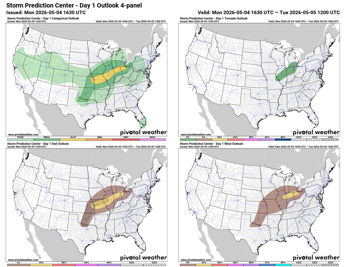
With regard to weather we more typically associated with May — severe storms — a slight (level 2 of 5) risk of severe weather is now in place for this afternoon and evening from the Kansas City metro area to western Lake Erie. Scattered strong to severe storms are expected to develop along a southward moving cold front — large to very large hail the primary risk in western parts of the slight risk, with damaging winds and possibly a few tornadoes in eastern areas. A conditional risk for a few severe storms with very large hail will extend back to the southwest into the Southern Plains.

A threat of severe weather will continue along this front as it sags toward the Mid-South on Tuesday. By Wednesday, another upper level disturbance will interact with the slow moving front to bring a potentially more organized and higher end risk for severe storms to parts of the South as seen on the day 3 NCAR AI severe weather probabilities (upper right hand graphic above).
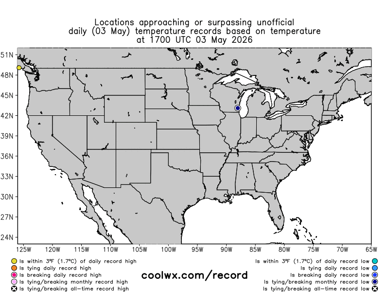
The record temperatures over the last day pretty clearly shows the weather pattern over the country: an upper level trough bringing abnormally cool temperatures to the Southeast while the Pacific Northwest saw record highs under an upper level high pressure area. Portland set a record high of 91F, and reached 90F on the second earliest date on record ever (earliest April 30 1998). The upper level high pressure area producing this anomalous warm weather is expected to intensify and expand over the next several days, and by early next week numerous record warm temperatures appear likely for the western United States.
Just a reminder that if and when severe weather becomes an issue, I will be sharing occasional thoughts and updates on Substack Chat, which is a benefit for those who support Balanced Weather with a paid subscriber — along with occasional posts on Facebook, BlueSky and Substack Notes.

Leave a comment