Severe weather looks to potentially ramp up Wednesday across the South
May 05, 2026
I want to start off this morning’s newsletter by sharing an article that the New York Times (gift link) shared in their Opinion section a few days ago. It is a story about a small town in Iowa that used state and local resources to effectively plug a gap in flood monitoring on a small stream near the Mississippi River.
I strongly encourage you to read the entire story. A quick summary is that the mayor of Riverdale, IA discovered last May that — much to his surprise and chagrin — the federally maintained streamflow gauge on flashy Duck Creek in his town had been pulled and was no longer in service, and that the federal scientist who oversaw the gauge and whom he had a relationship with had left the agency (I assume the US Geological Service) due to the DOGE Deferred Resignation program. Luckily, the mayor of the small town is a civil engineer for the US Army Corps of Engineers. He was able to work with the University of Iowa’s Iowa Flood Center to install a small, cheap experimental streamflow gauge they had developed on the stream. This gauge proved to be very beneficial in enabling the mayor to deal with a potential flash flood shortly after the gauge was installed.
My sense is the NYT shared this article with the framing of a positive story about how state and local governments can pull themselves up and fix problems — which of course it is. However, as someone who was intimately involved with the federal science apparatus meant to keep people safe and informed from flooding risks, I read this article with increasing anger and, indeed, despair about what we have lost in the last 15 months.
It starts with the fact that the gauge itself — which was obviously a key flood monitoring tool for this small town — was apparently pulled out of service without any coordination or notification. That is likely because of the fact that the federal scientist responsible for it abruptly left the government during the period of chaos when literally thousands of experienced federal scientists left agencies like NOAA and the USGS. Imagine how many times this scenario that affected Riverdale, IA has been repeated across the entire country in the last 15 months.
Now the town was left without any way to monitor their flashy stream. Luckily for them, their mayor happens to be a civil engineer for the federal government, enabling him to rapidly connect with the extant Iowa Flood Center and quickly get an inexpensive replacement gauge. As the NYT notes, it is awesome that Iowa has such a resource for its state. However, how many small towns and cities around the country are not lucky enough to have a flooding expert as their mayor and also do not have access to the Iowa Flood Center, which is a very unique research institution? The answer, of course, is likely hundreds or thousands.
We as citizens can and should have serious conversations about what the roles of federal, state and local government should be in weather and flood forecasting and monitoring, and how each of these levels of government should invest their limited resources. However, the fact is that state and local governments have traditionally not borne much responsibility in these areas. If we as a nation want to adjust the overall balance of responsibility, it should be done in an organized manner with a thoughtful plan — not by DOGE and OPM haphazardly getting rid of thousands of experienced federal scientists and reducing funding for critical items like streamflow gages without even notifying the affected local communities. (To be fair and clear, the NYT article does say that the DOGE cuts should be reversed.)
Furthermore, that plan needs to acknowledge that the resources that states and local communities have vary tremendously — and that by reducing the federal footprint of weather and flood forecasting and monitoring responsibilities and transferring it “downward,” we are likely ensuring a much more uneven level of warning and forecast services than we have today. Iowa is lucky to have some viable state resources to leverage to help them with flood forecasting — are we expecting even smaller resourced states like Mississippi and Vermont, which have their own serious flooding issues, to stand up their own state flood centers? How long will that take and how much will it cost?
The Texas Hill Country flash floods last year is an illustrative example of the real world, life and death nature of these questions. In the wake of that catastrophe there have been numerous calls for increasing the streamflow and rain gauge network on the upper Guadalupe River to enable the NWS and state and local officials to be able to much better track future flash flood waves moving down the river. Who should be responsible for procuring and maintaining those gauges? Luckily, the state of Texas likely has the resources that they can make this a priority if they so desire. There are dozens if not hundreds of flashy rivers and streams around the country that need similar hydrometeorological gauge networks. Are we as a nation willing to leave the responsibility of that monitoring to state and local jurisdictions? Maybe we are —but we need to be clear-eyed that without a serious plan and oversight, that decision will likely lead to uneven results and almost surely will allow catastrophic events to continue to happen without adequate warning.
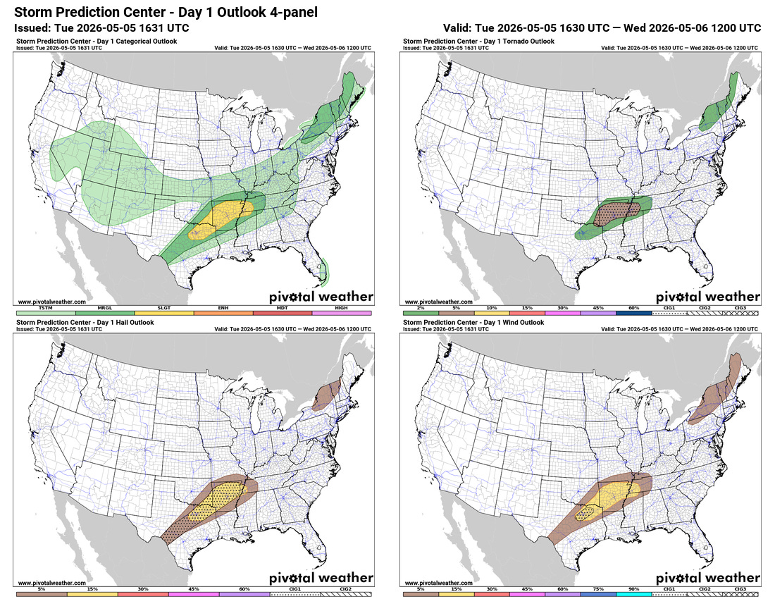
Finishing off today with a quick discussion of the severe weather potential the next couple of days. Some scattered supercell storms are expected to develop into this evening across parts of the south central United States along the slow moving cold front dropping south across the region. Large to very large hail, damaging winds and a few tornadoes are possible with the most intense storms.
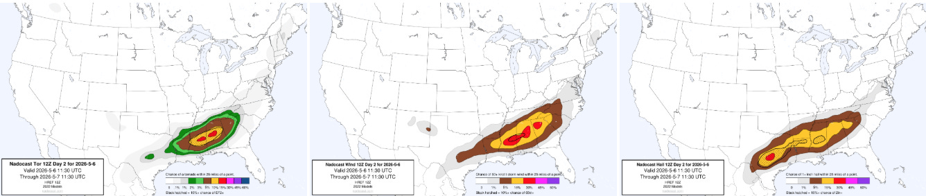
Wednesday into Wednesday night looks to have the potential to be a more widespread, higher end severe weather period across the South as the front becomes quasi-stationary and a new upper level disturbance interacts with it. There is still some uncertainty about how many storms will develop in this region and potentially interfere with how unstable the atmosphere becomes. However, very moist air will be flowing north off the unusually warm Gulf and if some daytime heating can help destabilize the atmosphere, a higher end severe weather and tornado threat could evolve as shown by the Nadocast AI severe weather probabilities above. We will be keeping a close eye on high resolution model and observations trends as we head into Wednesday.

Leave a comment