Potential for higher end severe weather in the South this afternoon and evening – and Colorado dealing with a late season heavy snowfall
May 06, 2026
I was happy to be one of the scientists interviewed by National Public Radio correspondent Frank Morris for his story about NWS budget and staffing issues that aired this morning. In my opinion, his story did a good job of looking at the issues in a measured and balanced manner, and I encourage you to take a listen.
One of the items that Frank discussed, and that has been a common topic of conversation among the media and meteorologists this spring, was the ongoing issues with NWS upper air balloons and potential impacts on the forecast. Interestingly enough, the atmosphere presented us another possible forecast situation last night in which upper air soundings may have played a role — and I think it is an illustrative example worth taking a look at.

As I highlighted in yesterday’s newsletter, the Storm Prediction Center had a slight risk of severe thunderstorms outlooked over the South Central US yesterday, and one of the areas of particular interest for possible tornadic activity was the Mid-South. Late Tuesday afternoon, SPC issued a mesoscale discussion highlighting an increasing tornado threat across northern and central Arkansas, and around 6 pm CT they issued a tornado watch for this region.
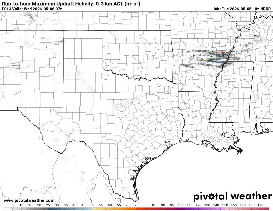
High resolution models were forecasting that supercell severe thunderstorms would develop along a southward moving cold front and move east/southeast just ahead of the cold front. The models forecasts of updraft helicity — a proxy for storm rotation — showed strong signals for low level rotation within these storms indicative of tornadic potential.

However, as the evening went along, very little in the way of severe or even strong thunderstorm activity evolved. Around 9 pm, SPC issued a mesoscale discussion to provide an update on their thinking about the watch. They noted that to this point all of the thunderstorm development had been behind the cold front and elevated — I talked about elevated thunderstorms in my Friday newsletter and why they are much less likely to produce tornadoes. SPC also noted, though, that the high resolution models continued to insist that surface-based thunderstorm development was still likely:
However, short-term model forecasts suggest that additional storms will develop over the next few hours ahead of the front from central Arkansas northeastward into western Tennessee. If this happens, then surface-based storms will become likely. The latest WSR-88D VWP at Little Rock has 0-6 km shear near 75 knots with 0-3 km storm-relative helicity around 550 m2/s2. Thisenvironment will be favorable for severe storms if cell coverage markedly increases late this evening as the HRRR suggests. Under this scenario, new weather watch issuance would probably be needed to the east of the current watch.
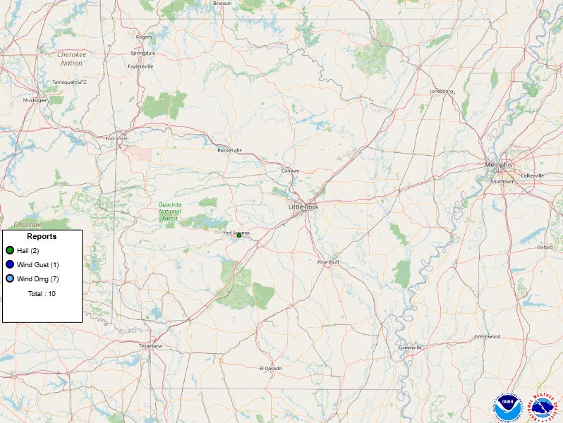
In the end, the surface-based thunderstorms never materialized. No tornado warnings were issued. Only a few severe thunderstorm warnings — primarily for marginally severe hail from elevated storms — were sent out well after midnight, many hours after the tornado watch had initially been issued and then expired. The lone severe weather report over the state of Arkansas overnight was a 1” hail report from Hot Springs.
It is important to recognize that NWS forecasters were missing a critical piece of information when making all of their forecasts and outlooks yesterday. The morning and evening upper air soundings from Little Rock were missing — as they have been since February 24th. My understanding is that the issue here is not directly related to meteorologist staffing but rather to an issue with the upper air building where balloons are prepped for release. I do not know why the outage has been so prolonged — but the bottom line is that the data is missing.
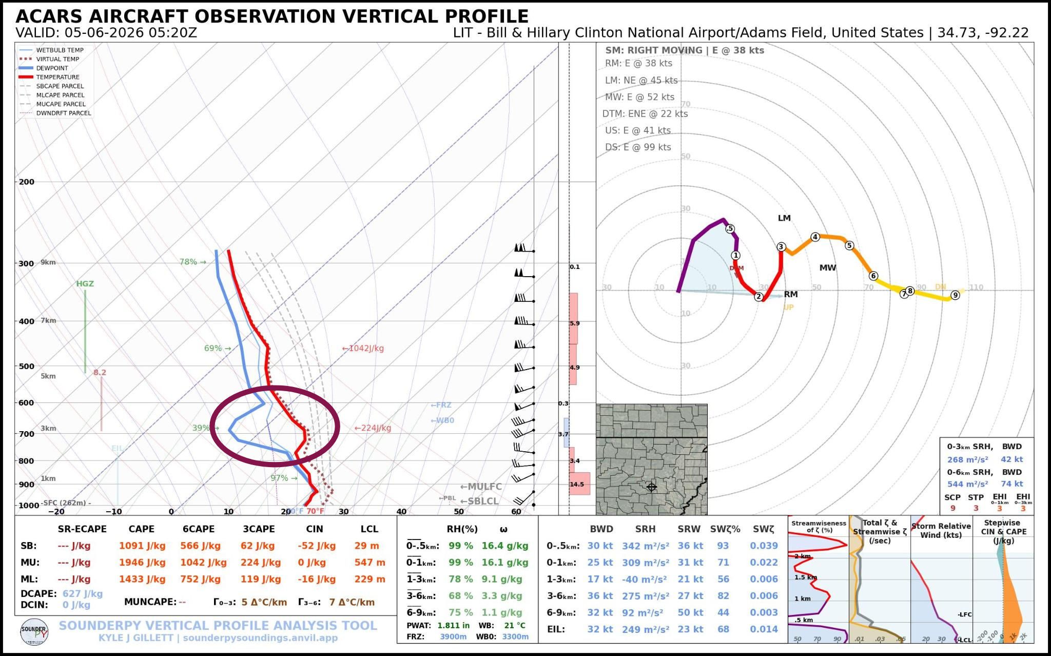
Luckily — and unlike nearly 40 years ago when I started in meteorology — we do have other ways to obtain upper air data for the models and forecasters to use. One of these is soundings obtained when specially equipped commercial aircraft are landing or taking off at an airport. One of these soundings was available from Little Rock shortly after midnight last night. It showed that there was a “cap” — an area where temperatures were increasing and moisture was decreasing as I highlighted above — at about 10,000 ft AGL.
Capping inversions such as this are a critical feature that meteorologists look for in making severe weather forecasts as they put a “lid” on rising air trying to develop into thunderstorms. Last night, the high resolution models continued to insist that this cap would erode and surface-based thunderstorms would form. This aircraft sounding shows that while the cap did become weaker, it remained strong enough to keep any surface based thunderstorms from developing ahead of the front and posing a more serious severe weather risk.
Unfortunately, aircraft soundings are only available occasionally, and in this case it arrived well too late to help with the tornado watch issuance (a mid-morning Tuesday partial aircraft sounding from Little Rock showed a much stronger cap). Would upper air sounding data from Little Rock have made a difference in the model and human forecasts, outlooks and watches for this event? Of course, there is no way to know for sure because the data is missing.
However, my experience based answer is: yes, it would have helped, but of course we cannot know how much. It could very well have kept what ultimately ended up being an unneeded tornado watch from being issued — a watch that likely resulted in significant extra staffing expenses for entities like NWS, emergency management, broadcast media, and potentially caused unnecessary cancelation of some events. Expenditures and decisions such as this are being made every day based on NWS forecasts, warnings and watches — and each step we take backwards in its capacity is going to lead to more unnecessary societal expense and disruption just as it can also lead to lack of warning and the resulting negative consequences.
So we have another critical and challenging severe weather forecast this afternoon and evening. The cold front that was being monitored for severe storm development last night is now slowly pushing into the Lower Mississippi Valley. A strong upper level disturbance is approaching the region from the west, and is expected to trigger the development of severe thunderstorms across this region this afternoon.
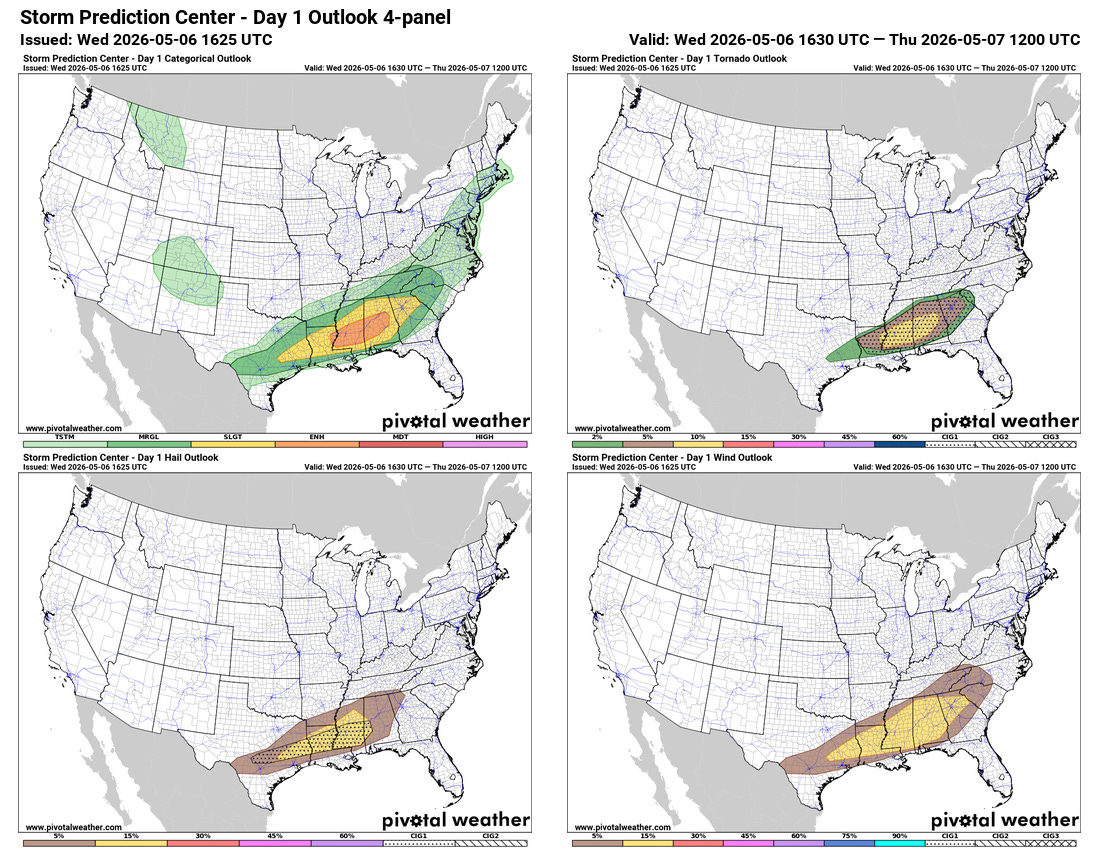
Mid level winds will become quite strong for early May, resulting in a favorable environment for rotating supercell storms capable of large hail and damaging winds. Clouds are rather widespread across the region at midday, but some breaks are occurring, and if the atmosphere from Louisiana into Alabama can become sufficiently unstable, these storms could be rather intense with the potential for very large hail and damaging winds. Later this afternoon, low level wind shear will also increase, which could result in an increase in the risk of tornadoes. An elevated (level 3 of 5) risk of severe weather is in place as shown above.

Even though this region remains in significant drought, thunderstorms with very heavy rainfall are expected to move repeatedly over the same areas along the US Highway 84 corridor of Mississippi and Alabama, which will likely result in flash flooding, with urban areas being particularly prone to more significant impacts. A moderate (level 3 of 4) risk of flash flooding is in place.

Snow! In May! As discussed a couple of days ago, parts of the central Rockies are finally getting the snowfall they dreamt about all winter and never really materialized.
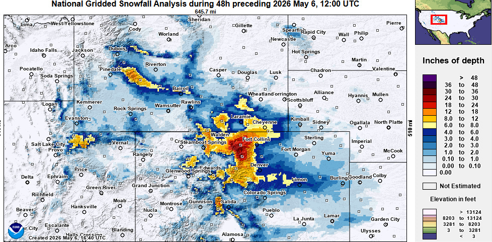
The snowfall has been heaviest in the high elevations and foothills northwest of Denver, where 1 to 2 feet of snow has fallen. The heavy snow on top of trees that have leafed and budded well earlier than normal resulted in downed trees and limbs and many power outages, peaking at more than 50K customers out in the area around Boulder. The moisture from this snowfall is obviously incredibly welcome to this drought plagued region.
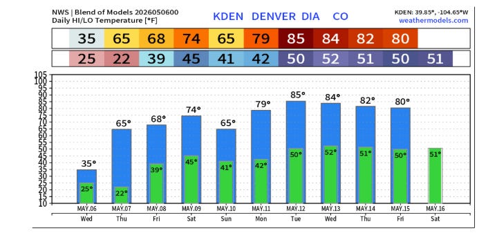
The snow itself will not be around long other than at the high elevations though. Temperatures will be in the 60s in the Denver metro by tomorrow, and mainly in the 70s and 80s for the coming 10 days.
Just a reminder that if and when severe weather becomes an issue today, I will be sharing occasional thoughts and updates on Substack Chat, which is a benefit for those who support Balanced Weather with a paid subscriber — along with occasional posts on Facebook, BlueSky and Substack Notes.

Leave a comment