Multiple rounds of severe storms with potential intense tornadoes centered on Mid-Missouri Valley region, while southern High Plains and Rockies deal with serious wildfire risks
May 17, 2026
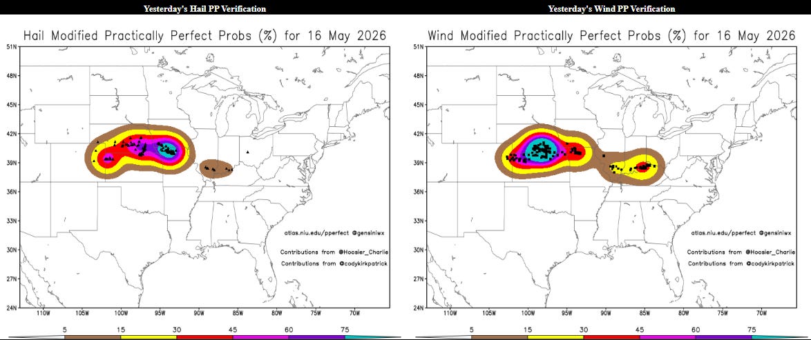
Saturday ended up being a very busy day for severe thunderstorms, with nearly 400 reports of severe weather including 60 reports of significant wind gusts (75 mph or greater) or hail (2” or greater) and a few tornadoes. Above are the post-analyzed hindcast severe weather probabilities based on the reports received, and the combination of the coverage and intensity of severe weather appears to have been more at a moderate (level 4 of 5) risk in retrospect. As I noted in yesterday’s post, the Nadocast AI probabilities and HREF (high resolution ensemble forecast) appeared to do a good job in capturing the area of intense supercell development in the vicinity of Mid-Missouri Valley that resulted in numerous very large hail reports.
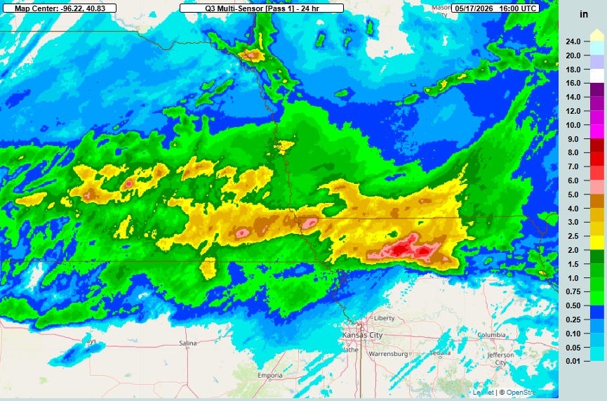
Training thunderstorms also produced some very heavy rainfall totals across this same region, with Grundy County in north central Missouri being ground zero with flash flooding causing buckling roads and a measured rainfall CoCoRaHs rainfall report of 7.43″ (thanks to my colleague Ken Howard for alerting me to this event).
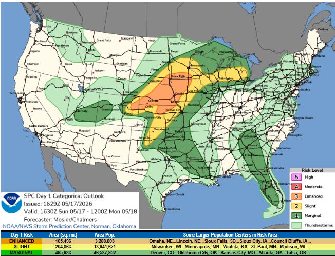
The very active severe weather pattern will continue today, as the Storm Prediction Center has a large enhanced (level 3 of 5) risk from southern Minnesota back into the central High Plains.
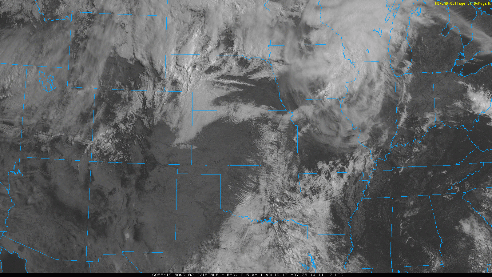
Morning visible satellite imagery shows that low level moisture is surging north through the central part of the country into an area that will see plenty of daytime heating today, resulting in a very unstable airmass across the region. The satellite imagery also suggests several east-west oriented boundaries leftover from yesterday’s thunderstorm activity, which will provide a particular focus for thunderstorm development as an upper level disturbance moves northeast into the region.
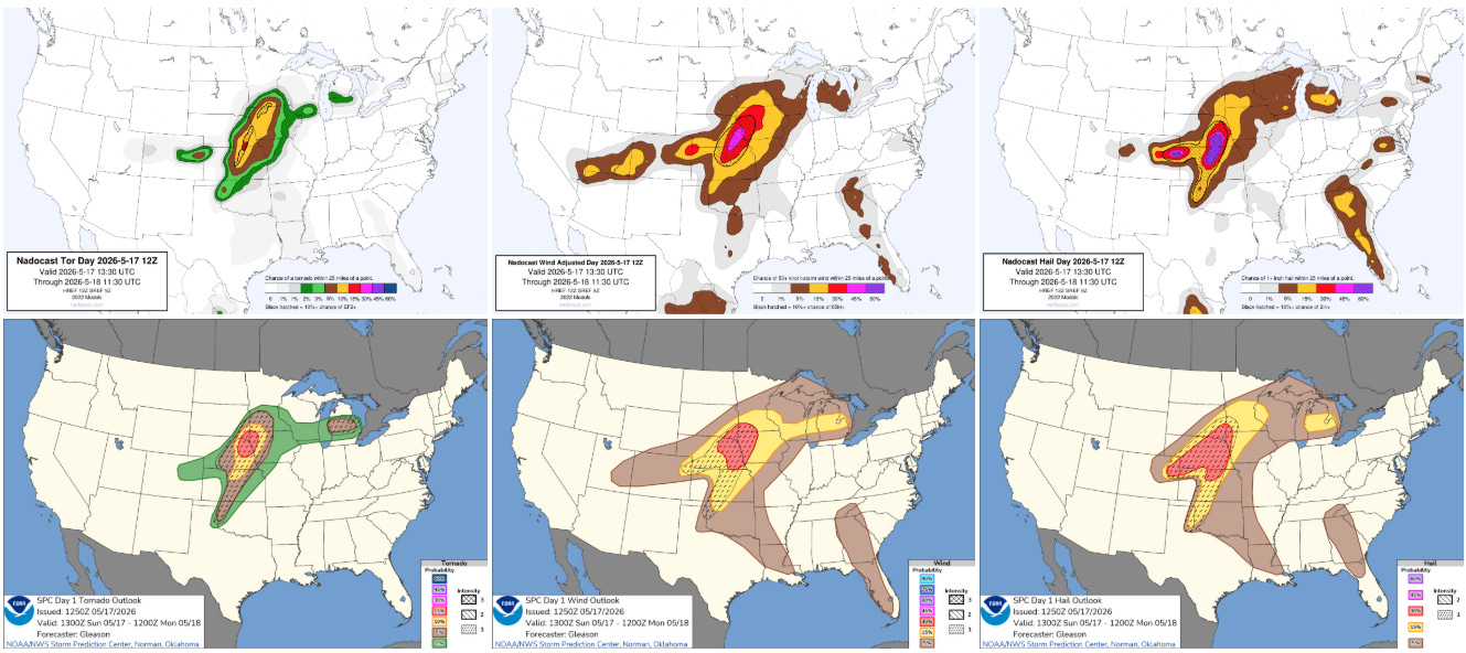
Severe weather hazard probabilities from the Nadocast AI system (top) and Storm Prediction Center bottom show that as severe thunderstorms develop late this afternoon, the most intense storms will have the potential to produce significant severe weather of all types, including strong tornadoes. The peak risk area looks as if it will be from central Kansas into far southwest Minnesota late this afternoon into this evening.
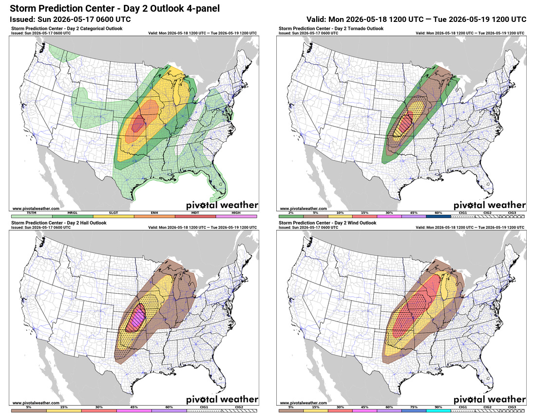
Yet another high end severe weather day is expected on Monday as the final, most intense upper level disturbance lifts northeast out of the trough that has been evolving over the western US. A moderate (level 4 of 5) risk of severe weather is centered on central and eastern Kansas into southeast Nebraska as an extremely volatile atmospheric setup is expected to support intense supercells capable of giant hail and strong to violent tornadoes Monday afternoon and evening.
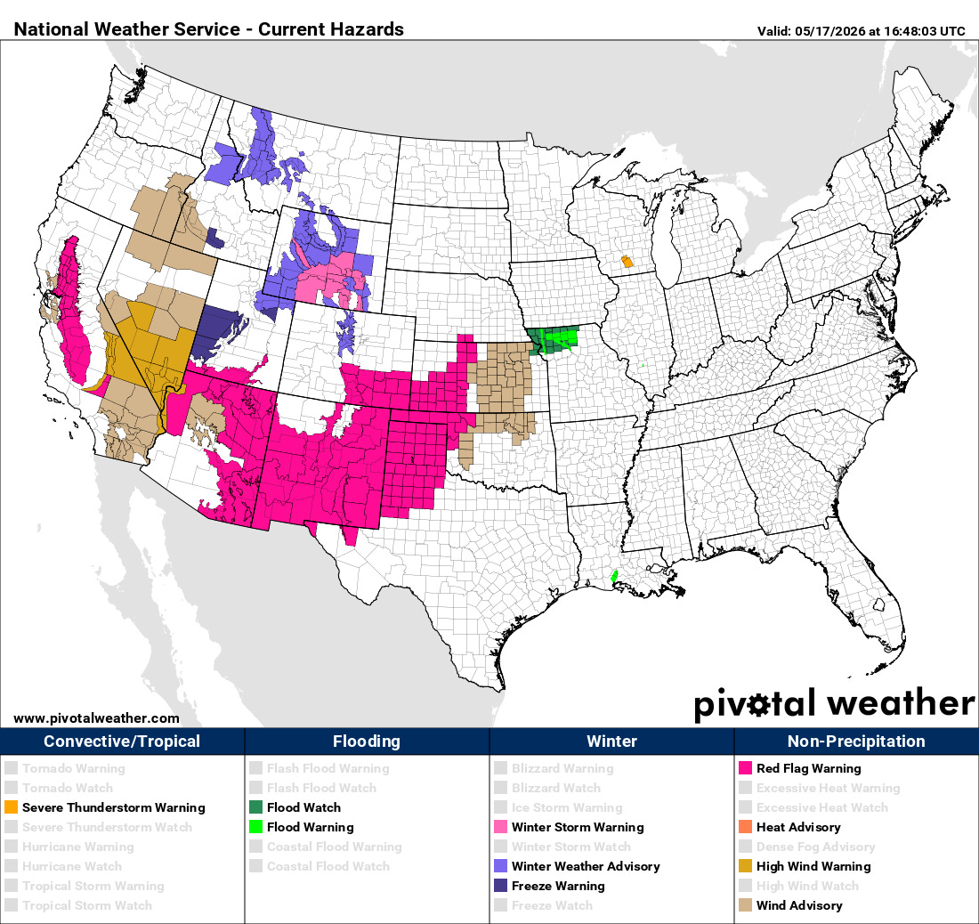
Unfortunately, this weather pattern is not only supporting high end severe weather risks, it is also favorable for serious wildfire danger. Red Flag Warnings are in place from the central Plains across much of the Southwest due to the combination of ongoing drought and strong, dry west to southwest winds that will be supportive of rapid fire growth and spread.
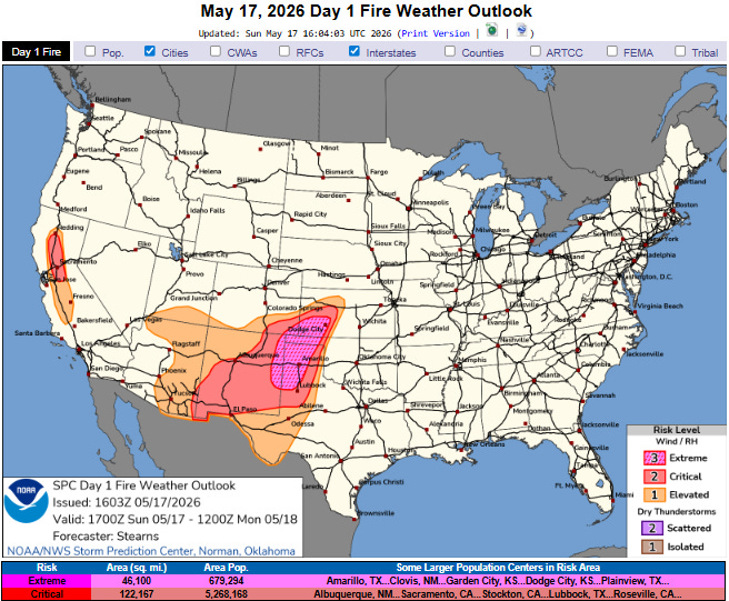
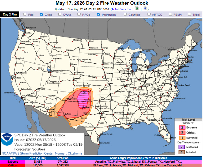
The most dangerous conditions are expected to be centered around the Texas and Oklahoma Panhandles where SPC has a relatively rare extreme (level 3 of 3) fire danger category forecast. This area has already been dealing with significant wildfires the last several days, and additional rapidly spreading fires are possible each of the next couple of afternoons due to the combination of very low relative humidity (bottoming out around 5% each afternoon) and sustained winds of up to 30 mph. Winds will be particularly strong on Monday afternoon when gusts to 50 mph look likely.
One final threat to note is flash flooding. While overall conditions over much of the central United States have been quite dry and this setup is not favorable for widespread heavy rainfall, as we saw over northern Missouri last night training thunderstorms in this moist environment can produce localized very heavy rainfall and flash flooding. A flash flood watch is in effect for northern Missouri where heavy rainfall fell the last 24 hours as shown in the hazard map above, and some isolated flooding issues could arise in other areas due to thunderstorm produced torrential downpours.
Programming note: As a reminder with severe weather expected the next few days that as my schedule permits I will be doing live Substack chats and occasional videos with updates and interesting things I see. I am definitely planning to do live chats later this afternoon and evening, and likely a video at some point this evening. These live events are benefits that paid Balanced Weather subscribers receive in thanks for their support. Any videos I do will be available as soon as I can get them processed as posts and on my YouTube Channel.

Leave a comment