Severe thunderstorms with intense tornadoes and giant hail, dangerous wildfires, and life-threatening flash flooding all a significant threat in different areas this afternoon and evening
May 18, 2026
Welcome to a new work week. An extremely active day of weather is expected today so going to get right into it – I’ll recap yesterday’s severe weather in a full recap post after today’s event.
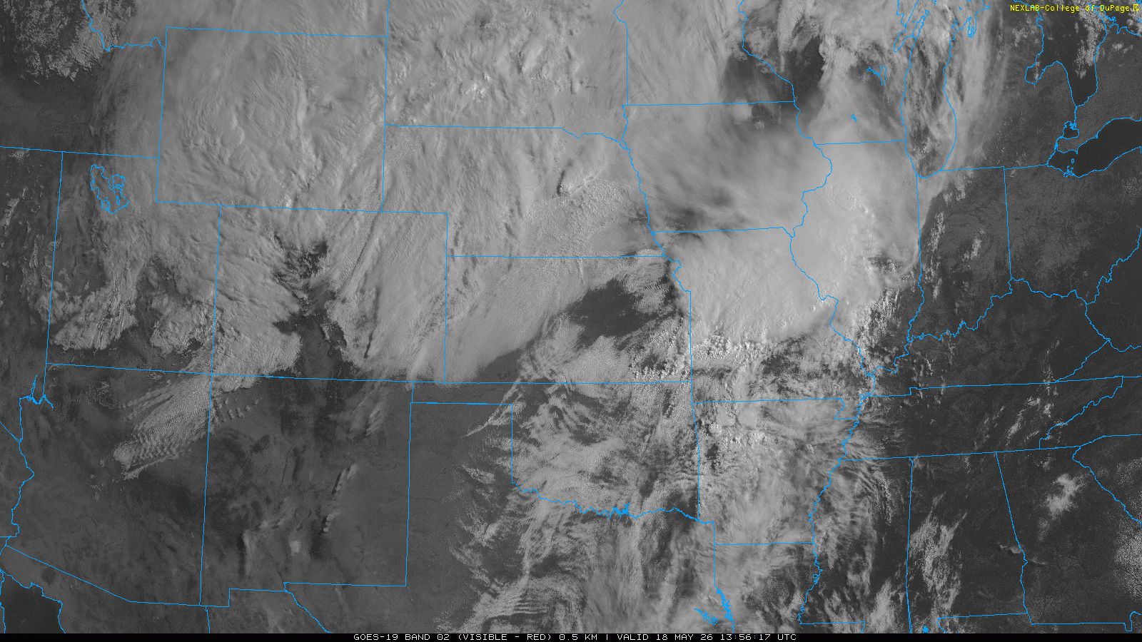
As is so often the case, the morning visible satellite loop does a great job of showing all of the various features in this very complex weather setup across the center of the country.

I cannot draw directly on the animation, so in this still image I am highlighting some of the features that will play a key role on today’s outbreak of severe weather and flash flooding in the central part of the country: an outflow boundary from overnight thunderstorms (purple dashed line), a stationary front marking the boundary between much cooler air and unseasonably warm air to the south of it (blue/red line), and the dry line (brown line) marking the edge of the very moist unstable air, with drier air (and extreme fire danger) west of it.
The orange ellipse marks the location of the strong upper level weather disturbance that we have been talking about driving this severe weather outbreak today. As this system is lifting northeast toward the Plains, southerly winds at lower levels of the atmosphere are increasing ahead of it. In the animation, you can see how this is causing the outflow boundary to stall and begin to retreat north, as well as the retreat of the low clouds marking the edge of the colder air across Kansas. East of the dry line across the eastern half of Kansas the atmosphere is rapidly modifying as sunshine and increasing southerly winds are yielding an increasingly moist and unstable atmosphere.
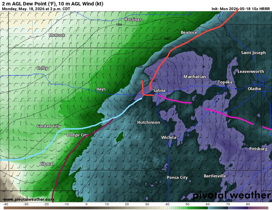
As the upper level disturbance continues to move northeast over the next several hours, a low pressure system will begin to develop at the surface. By mid-afternoon, the most recent run of the High Resolution Rapid Refresh (HRRR) model gives what looks like a reasonable depiction of the forecast evolution, with the low near Salina, and I have sketched in (crudely) the approximate positions of the various boundaries. There will probably be some subtle differences in the real atmosphere from the model forecast which will impact the actual atmospheric evolution.
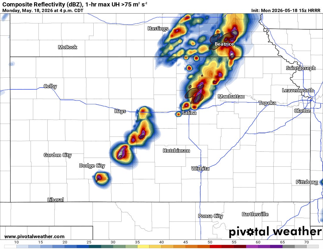
Regardless, between about 1 and 3 pm CT, several intense supercells are expected to develop in the volatile atmosphere across central Kansas — with the most serious tornado risk expected near the “triple-point” low and intersection of the old outflow boundary and front.
Low level shear will be extreme in this region as the low moves northeast, and if storms remain relatively discrete there will be a significant risk of intense tornadoes as shown by the HRRR forecast of low level rotation with these storms. If the storms develop into a line or have a lot of interaction between them, that could reduce the tornado risk some — but still a risk of strong tornadoes will continue as the band of storms moves east this evening. Giant hail and significant damaging straight line winds will also be possible.
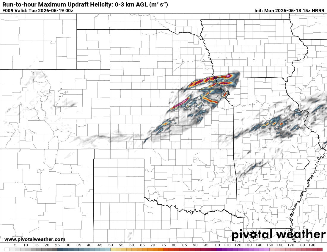
Farther east, the HRRR also implies some low level rotation in the storms developing along wherever the old outflow boundary sets up over Missouri and into southern Illinois. While the atmosphere will not be as unstable here as farther west, we will need to keep an eye on how unstable things become south of this old boundary and the potential for an increased severe/tornado risk here.
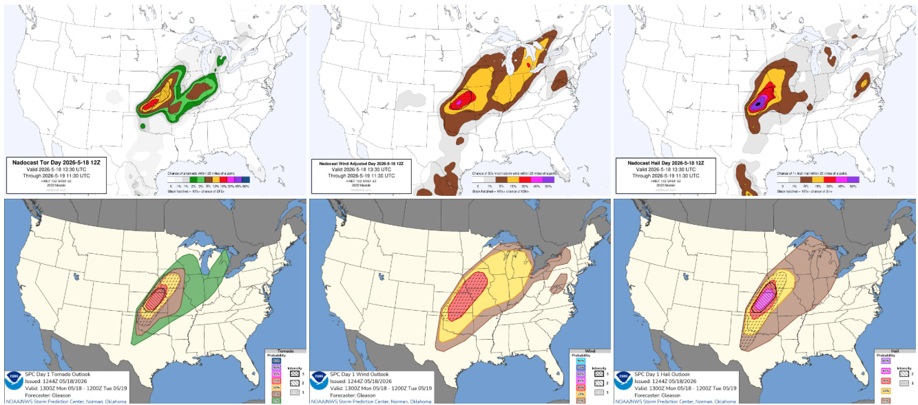
The most recent probabilistic forecasts from the morning Nadocast AI and the Storm Prediction Center continue to highlight Kansas into the Mid-Missouri Valley as the greatest potential for intense tornadoes and giant hail, and SPC has a moderate (level 4 of 5) risk in this area.
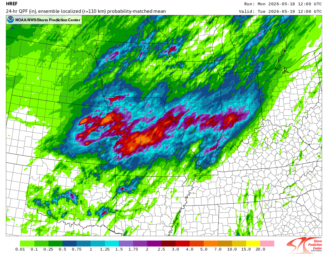
Heavy rain and flash flooding will also be a serious concern today, particularly along the old outflow boundary across Missouri and back up into the Mid-Missouri Valley where repeated rounds of thunderstorms with heavy rainfall are anticipated.

The Weather Prediction Center recently expanded a moderate (level 3 of 4) risk of flash flooding to encompass this entire area, and noted in their discussion that an “impressive setup for heavy rain” should develop this evening.
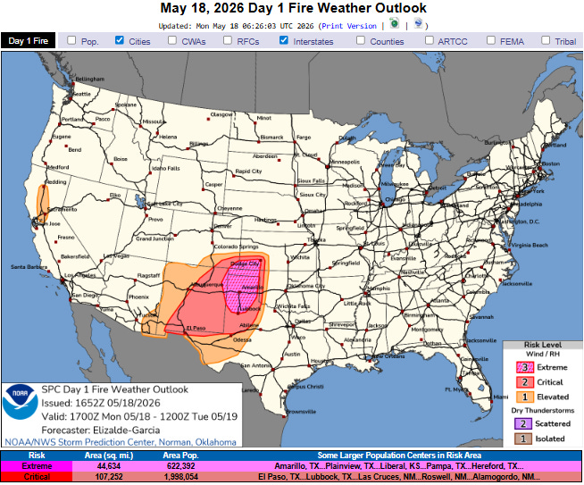
Last — and certainly not least — extreme wildfire danger is expected again this afternoon after this weekend saw several wildfires expand across the region and cause some evacuations. Sustained west to southwest winds of 25 to 35 mph with gusts as high as 50 mph will combine with extremely low (~5%) minimum relative humidities to results in dangerous wildfire conditions with SPC noting the potential for “wildfire spread at a life-threateningly fast pace.” Fire spread will be complicated late today and tonight as the cold front moves in from the north, causing an abrupt shift in the winds to northerly.
Given the extremely active weather anticipated today, I will be doing a live Substack chat much of the day starting at around 1 pm CT for paid subscribers. During the peak of any significant tornadic risk I am planning to do live video to look in detail at radar and other data. Depending on the magnitude of the risk (and if the chat load within the video doesn’t become too unmanageable) I may try to open this up for a period to all subscribers — but as a reminder, all of my live content (chat and video) is available as a thank you benefit to paid subscribers.

Leave a comment