Heavy rain in the South will help drought issues, but also bring a flash flood risk
May 20, 2026
Along with the ongoing wildfires in the south central United States the last several days, there has also been a rash of wildfires in California.
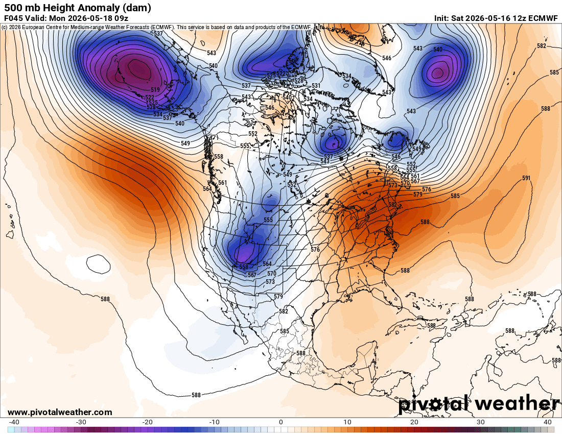
Having numerous active wildfires in California is somewhat unusual for this time of year. The strong upper level trough centered across the Rockies that produced all of the severe weather and active fire weather in the central part of the country is also a favorable weather pattern for offshore flow in California. This offshore flow is warmer and drier than the more typical springtime cool, moist onshore flow — and as stronger upper level disturbances moved southeast through the trough, periods of stronger offshore winds helped provide more favorable conditions for wildfires.
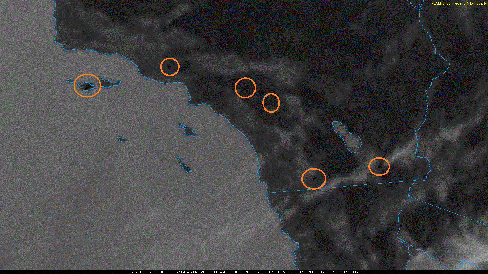
By yesterday afternoon, NOAA’s GOES satellite imagery was detecting hot-spots from several large wildfires across southern California. Based on data from the Watch Duty app, these fires are (from west to east) the Santa Rosa Island Fire, the Sandy Fire, the Bain Fire, the Verona Fire, the Tusil Fire and the Whitlock Fire. These fires have forced tens of thousands of people to evacuate and are mostly still uncontained. Thankfully, as the upper level trough east of the state breaks down this week, the weather pattern will become more typical of May with cooler, moister onshore flow which will hopefully enable firefighters to make significant progress on dealing with these fires. This morning’s post from the excellent Hotshot Wake Up Substack has more details about the California fires as well as other wildfire activity around the country.
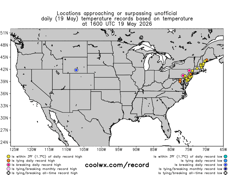
Downstream of the western upper level trough, a corresponding upper level ridge of high pressure has been bringing unusual warmth to the eastern United States as shown by yesterday’s loop of record temperatures from coolwx.com (note that you can also see some record lows in the cool air coming south behind the south moving cold front). Several of these records show up on this map with the bright pink of monthly records, and indeed a number of locations set all-time monthly records, including Newark with a high of 99F (tied previous record) and Philadelphia with a high of 98F (broke previous record of 97F). Per climatologist M. Herrera at Extreme Temperatures Around the World, the high of 97F at Cheswold, DE set a May monthly record for the state.
The number of monthly record high temperatures yesterday was a bit of another “wow” climate moment for me. Typically, monthly high temperatures in May are set right near the end of the month given that May is a transition month from spring to summer. Also, the current overall weather pattern is not that anomalous looking that it would scream to me a setup for a bunch of all-time records. The fact that a number were reached, including at least two at very long term climate sites (Philadelphia’s record goes back to 1873 and Newark back to 1843) is quite impressive.
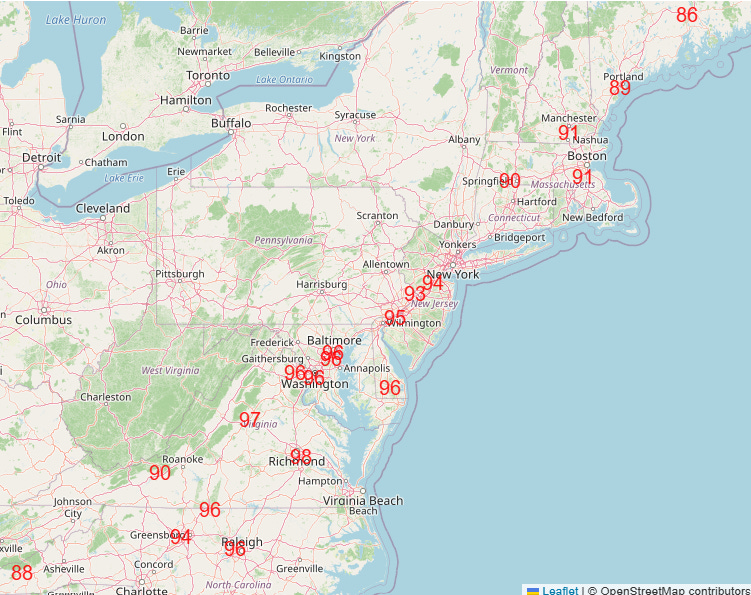
While it won’t be quite as hot today along the east coast, a number of daily record high temperatures should still be reached before the cold front finally pushes through and brings some cooler weather to the region.
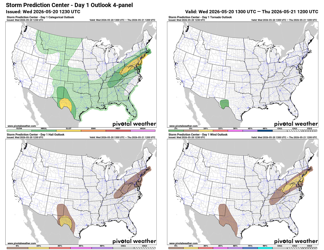
The cold front will also bring scattered strong to severe thunderstorms to the Mid-Atlantic region — the Storm Prediction Center has a slight (level 2 of 5) risk in place with damaging winds the primary expected risk. A slight risk is also in place for western Texas where supercells producing very large hail and possibly a couple of tornadoes are expected.
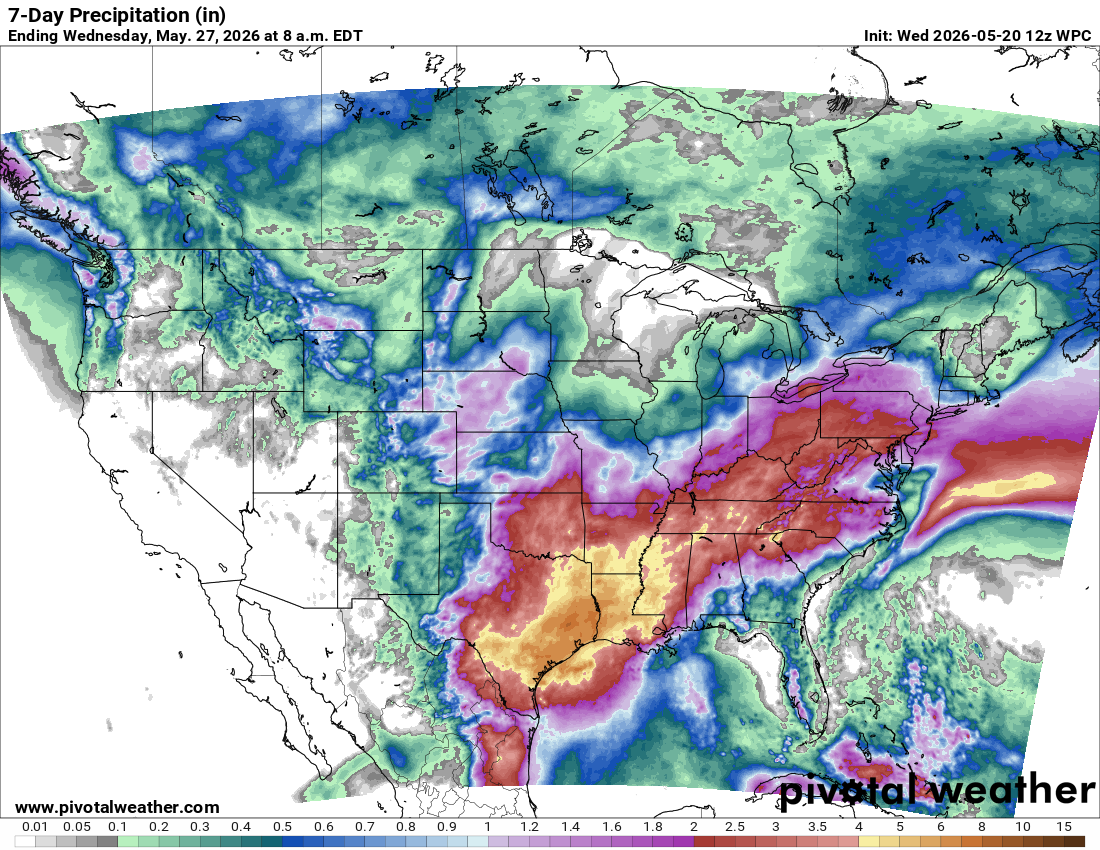
While some severe weather risk will continue to bubble up each day, particularly over the southern High Plains and the Southeast, heavy rainfall and flash flooding will become the increasing concern as we head through the remainder of the week. As the front stalls out, disturbances in the subtropical jet stream will interact with moisture pooling along the front to result in waves of thunderstorms with intense rainfall rates that could produce flash flooding in spite of also bringing some relief to ongoing drought over much of the area.

Today will see a large area of marginal to locally slight (level 2 of 4) risks of flash flooding from the Mid-Atlantic to the central Gulf Coast, with a larger slight risk over central Texas.

Today’s risk over Texas will expand to cover much of the south central United States on Thursday. For this weekend, the heavy rainfall and flash flooding threat will become particularly focused along the western and central Gulf Coast regions, where the models suggest multiple rounds of relatively slow moving thunderstorms producing heavy rainfall.
Programming note: On Thursday afternoon at 2:30 pm CT, I will be doing a video interview with Dr. David Sills, Director of the Northern Tornadoes Project and Deputy Director of the Canadian Severe Storms Laboratory. We will be talking about some of the exciting severe weather research going on in Canada — as well as some concerning issues with Canadian federal severe weather research that has some distinct parallels with issues the United States is facing. I think it will be a fascinating conversation, and I should have a recording posted on Substack and uploaded to the Balanced Weather YouTube channel by Thursday evening. Paid subscribers will receive an email later today or Thursday morning with the Google Meet link to listen in and ask questions on the live interview.

Leave a comment