Severe weather/wildfire risk of last several days transitions to heavy rainfall threat
May 19, 2026
Before I get into a recap of the last few days of severe weather and finally talk about some of the other weather stuff happening, I wanted to highlight a press release that NOAA issued yesterday about their observatory on Mauna Loa in Hawai’i. This observatory has been cutoff from regular vehicle traffic for more than 3 years after the volcano erupted in 2022, causing lava to flow across and bury more than a mile of the road to the observatory.
This damage caused a hiatus in operations of the observatory and a temporary move of the most critical operations — including the carbon dioxide measurements that serve as the basis for the famous Keeling Curve — to Mauna Kea. NOAA has been gradually working to restore access and operational capacity to the Mauna Loa Observatory ever since, and yesterday the agency announced that full vehicle access has been restored which will enable the final steps to bring the observatory back to full operational capacity to be implemented.
Obviously this is great news, but as Paul Voosen from Science pointed out, the bigger deal in the release is probably that NOAA is publicly committing to the observatory and to planned work to renovate and improve it. The observatory is operated by the Global Monitoring Lab (GML), one of the many NOAA Research labs that the Trump Administration has publicly announced it wants to eliminate along with its parent line office, the Office of Oceanic and Atmospheric Research (OAR, which the administration actually tried to pretend it had already successfully eliminated in its proposed FY2027 budget). The very fact that NOAA is outlining plans to update and modernize this observatory would seem at some level to be a tacit admission of the likely reality that the facility is going to remain open.
This jives with things I am hearing from colleagues still at NOAA that indicate that funding is flowing from higher levels to NOAA research labs and programs this year in a way that it did not in 2025. While this is more positive news, there are of course still plenty of issues. In particular, while the money is being allocated to the labs and programs, many of the incredibly complex new rules for purchasing, contracting and awarding research grants that were put in place by DOGE and other administration officials last year remain in effect, making the process of actually spending all of the money appropriated by Congress and allocated to the agencies extremely difficult.
Furthermore, while much of the media attention on job cuts in NOAA focuses on the scientists, the administrative side of the agency also lost a tremendous amount of personnel and experience with the DOGE reductions and early retirements. While the public may see these jobs as just “bureaucrats,” I know from personal experience that being able to successfully navigate the complex government processes for things like budgeting, awarding contracts and grants, and human resources are skills that take years of experience to obtain and are critical to support the scientific work agencies like NOAA perform.
Talking to colleagues still in NOAA, the loss of so many experienced administrative professionals is really making it challenging for the scientific goals of NOAA to be achieved, whether we are talking about the awarding of university research grants, obtaining contracts to repair critical weather observing facilities, or hiring science and technical employees. These are the kinds of issues I will be watching closely in the coming months.
Starting off the recap of yesterday’s busy weather with the severe thunderstorm activity, and as expected it was in fact active with over 400 reports of severe weather. The moderate risk area in the central US was hammered by numerous supercell severe storms which evolved into an intense QLCS (quasi-linear convective system or squall line) that moved east Monday evening. Numerous reports of tornadoes, significant damaging winds, and very large hail were received by the NWS. Luckily, though, the sheer number of storms and interactions between them helped minimize the potential for long tracked, violent tornadoes that the overall atmospheric setup could have supported.
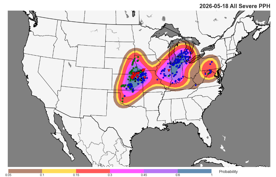
Where I want to give a mea culpa is allowing my focus on the central US severe weather risk to distract me from highlighting more aggressively the risk associated with the QLCS leftover from Sunday that revitalized and swept east through the Great Lakes region. As can be seen from the severe weather coverage map above, this area ended up having about as much overall severe thunderstorm activity as the moderate risk area. While it was not as high end and had limited tornado and large hail activity, the QLCS did produce a number of measured significant (75 mph or greater) wind gusts, including 75 mph at the NWS observing site and 81 mph at a nearby mesonet site in Grand Rapids. Around 100K customers were without power in the region at one point late Monday, mainly in Michigan.
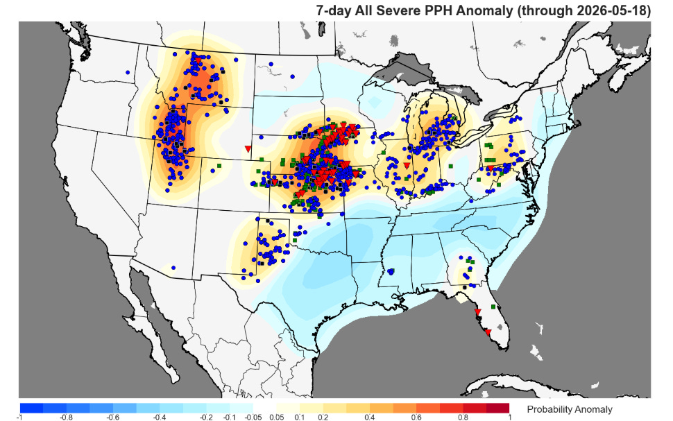
Yesterday was the conclusion of nearly a week of above normal severe weather that ran from the Northern Rockies east into the Lower Great Lakes, with the Mid-Missouri Valley being “ground zero” with multiple days of significant severe weather.
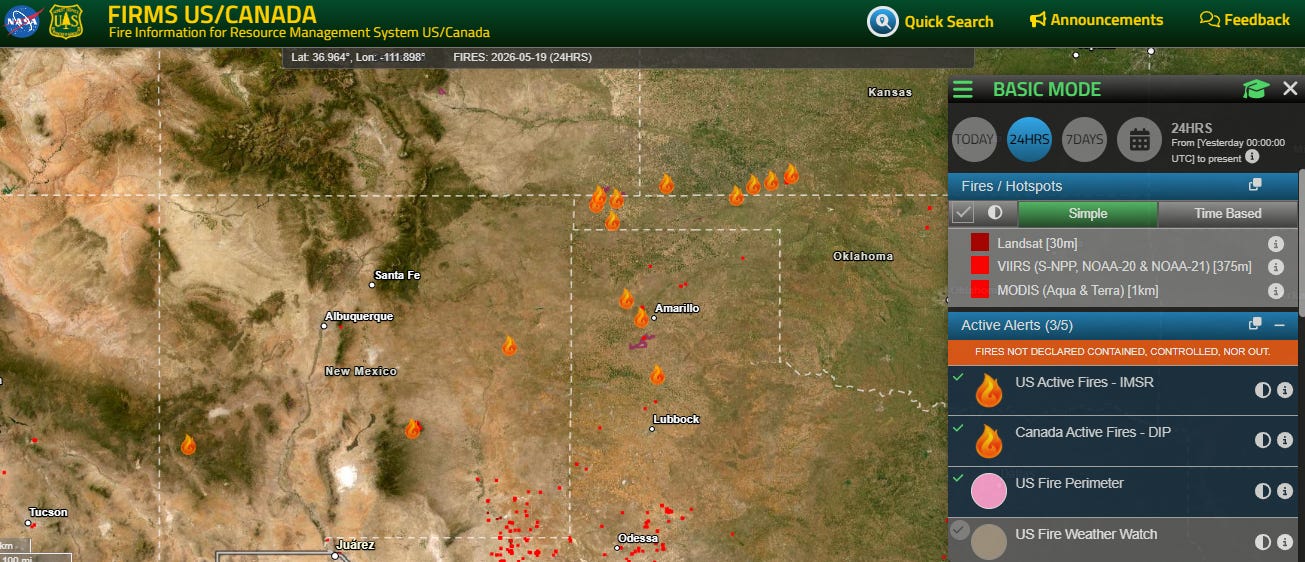
It has also been an active period for wildfires as well, with more than a dozen large wildfires now burning from New Mexico into southern Kansas. More evacuations were required Monday evening as fires spread in strong winds across southwest Kansas and the Texas Panhandle.
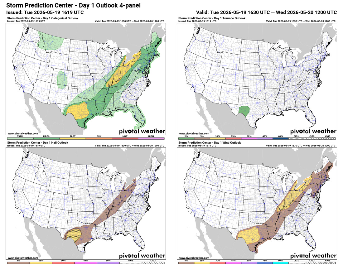
Today will be kind of a transition day as the cold front that was the focus of the severe weather on Monday continues to slowly sag south. Severe weather will continue to be a risk along it — but the magnitude and coverage will be less with slight (level 2 of 5) risks focused in the Lower Great Lakes and Texas.
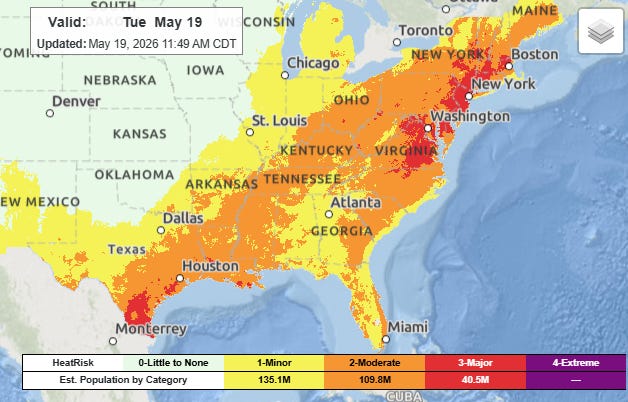
Ahead of the front, unseasonable heat will continue with record highs possible this afternoon over much of the Eastern Seaboard. Combined with high levels of humidity, major heat risk will build in the urban corridor from Virginia to southern New England, with early season head advisories in place for some areas.
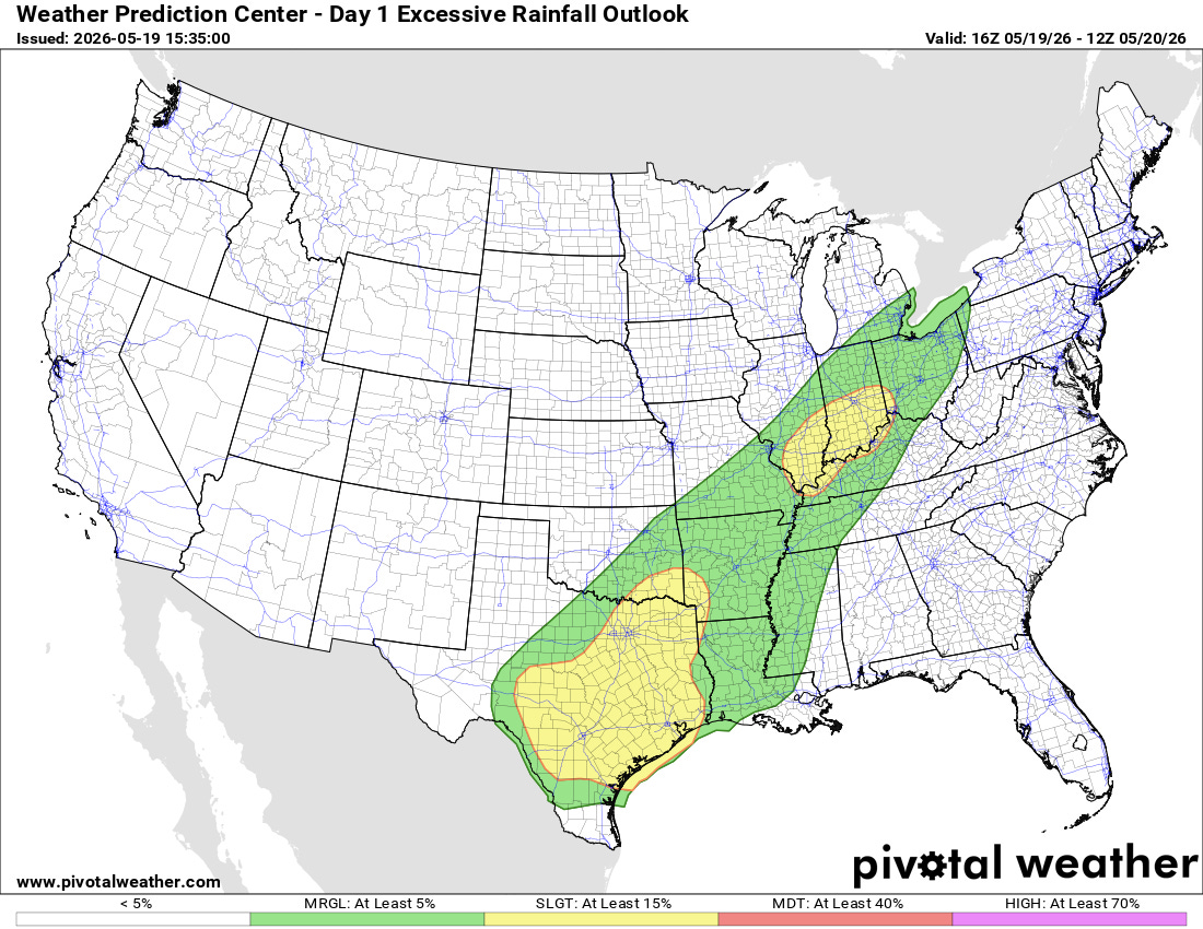
As the front continues to sag south over the next few days, the threat will gradually transition from severe weather to heavy rainfall and flash flooding. Today slight (level 2 of 4) risks of flash flooding are in place for the lower Ohio Valley and from the Arklatex to the western Gulf Coast.
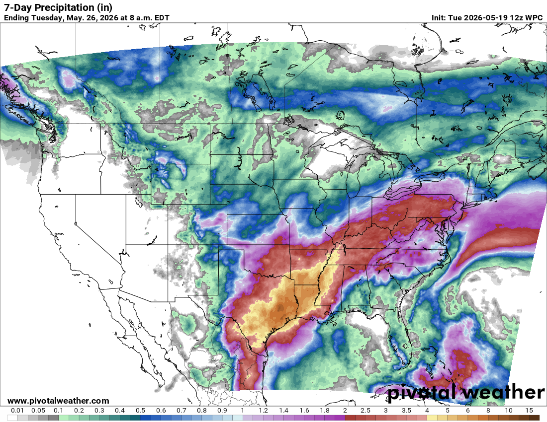
As the front stalls out, it will become a focus for heavy rainfall as disturbances in an active subtropical jet stream interact with high levels of moisture pooling along the front. While much of the area impacted is in significant drought, high rainfall rates over multiple days will also bring some risk of flash flooding.

Leave a comment