NWS Paducah has been down since late this morning, with severe weather and flash flood risks ongoing
Jun 08, 2026
For the second time in about 48 hours, an NWS office has suffered a massive communications failure during ongoing impact weather. In this case, the office is NWS Paducah KY, which serves western Kentucky, southwest Indiana, southern Illinois and southeast Missouri. On Saturday afternoon and evening, the NWS office in Wilmington, OH suffered a several hour comms failure during severe weather.
When an NWS office suffers a complete communications failure, the agency has “service backup” plans in which nearby offices step in and provide warnings and forecasts for the service area of the impacted office. In this case, the NWS office in Louisville, KY appears to have been the primary backup office. Per the excellent Iowa Environmental Mesonet website, the Louisville office looks to have issued 10 severe thunderstorm warnings, a tornado warning and a flash flood warning for the Paducah service area this afternoon as a complex of strong to severe storms moved across the region.
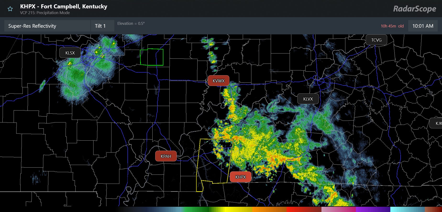
This radar image from RadarScope shows the radar image from the Fort Campbell, KY (KHPX) NEXRAD radar at 10:01 am CT, the last image received before the comms outage — and also shows that the radar data from the Paducah, Fort Campbell, and Evansville, IN (KVWX) radars are unavailable (red site IDs). NEXRAD radar data flows to data collection and processing sites at NWS offices. The Paducah office is the hub site for these three radars, and thus that data is unavailable.
Obviously, I do not know the specifics regarding the comms failure, but typically these sorts of prolonged outages are due to fiber communications issues. In this sort of comms outage, the local office would be able to view their own radar data, i.e., the Paducah forecasters would be able to see their radar data and potentially (have not been able to get a clear answer on this) some products from the Evansville and/or Fort Campbell radars.
However, none of that radar data is available to anyone else — so in a backup situation like this, typically forecasters at the impacted office (Paducah) would describe to forecasters at the service backup office (Louisville) what they are seeing in real-time on radar via chat or cell phone to help in the warning process. Having been on both ends of this process in various past situations while at NWS Jackson, I can assure you that while it is better than not having any local radar data, it is definitely suboptimal and not nearly as timely or effective as the “normal” warning process. Additionally, most NWS offices now have “Voice over IP” (VoIP) telephone systems — meaning if their internet is completely down due to a fiber cut, they also have no ingoing or outgoing landline telephone service, further hampering severe weather operations.
The radar data not being disseminated also means it is not being ingested into the critical Multi-radar Multi-sensor (MRMS) system that is used extensively by the NWS and private meteorologists for warning and forecast services. In this loop of the instantaneous rainfall rate from MRMS this afternoon, one can clearly see how the data becomes more “blocky” and “blobby” as the storms move into the degraded radar coverage in southeast Missouri, southern Illinois and western Kentucky — and then the fidelity improves again as the storms move closer to the operational radars in Louisville and Nashville.

The storms that moved across the area were rather impactful, causing several thousands of power outages in southeast Missouri and serious flash flooding in Cape Girardeau, MO. A person had to be rescued from the submerged vehicle in picture above, and law enforcement reported that the individual was transported to the hospital after they “nearly drowned.” Cape Girardeau Mayor Robbie Guard sent Heartland News this statement on Monday evening:
“This evening, our community experienced an extraordinary weather event, with multiple inches of rain falling in about an hour. This amount of rainfall overwhelmed drainage systems in some areas and has resulted in flooded roadways, stalled vehicles, and localized flooding throughout the city. Please know that city crews, emergency personnel, and public works employees are actively responding and doing everything possible to address impacted areas and keep residents safe. Their efforts will continue until conditions improve.”
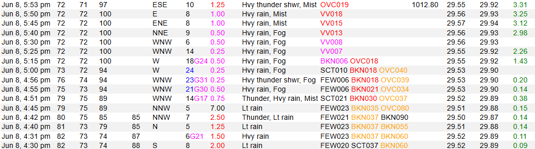
This significant flash flooding was not due to training thunderstorms, but rather just incredible rainfall rates overwhelming infrastructure and small streams, with the Cape Girardeau automated observing site reporting 3.31” (!) of rain in the hour ending at 6 pm CT.
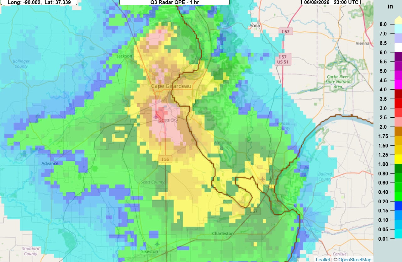
NWS offices extensively utilize rainfall and hydrologic products from the MRMS system in their flash flood warning operations — and these products rely heavily on low level radar coverage which would have been seriously degraded today in this area by the comms outage as I discussed above. The 1-hour MRMS rainfall estimate maxed out at about 2.5” near the airport, a significant underestimation of the actual 3+ inches of rainfall. To be fair, radar rainfall estimates are always imperfect at some level, but not having the low level radar data certainly did not help here.
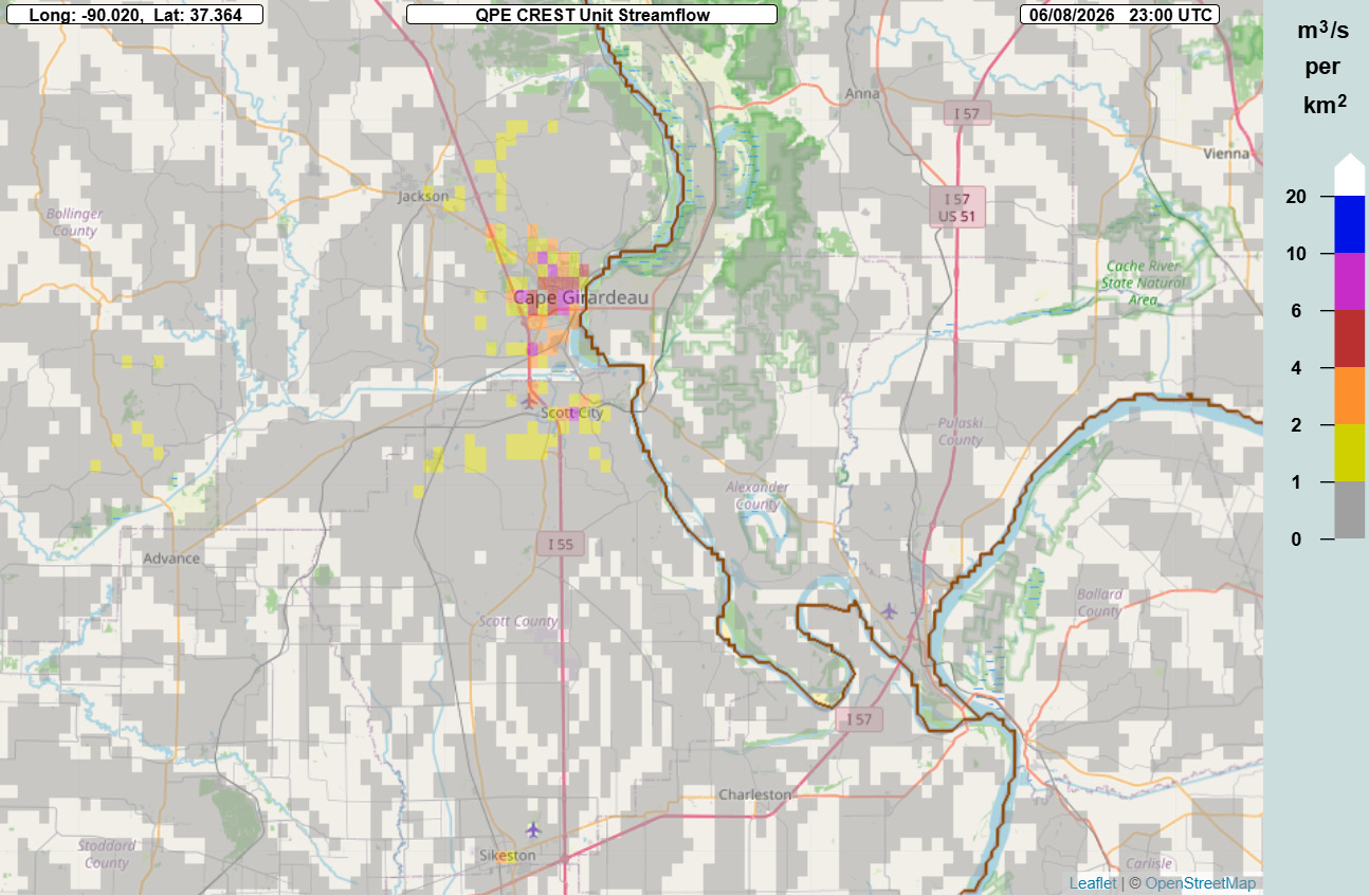
Even with this underestimate, the MRMS FLASH unit streamflow product — which takes the rainfall estimates and runs them through a hydrologic model to obtain inundation estimates — still showed high values over Cape Girardeau indicative of potentially significant flash flooding. The Louisville office did issue a flash flood warning for the area at 5:29 pm — this was already 30 minutes into the heavy rainfall and the warning stated that flooding was already in progress. The warning also was not a “considerable” level warning, meaning that the Wireless Emergency Alert cell phone alerting system was not triggered by the flash flood warning.
Obviously, how much the issues with the missing radar data and degraded comms might have played into what at a cursory analysis appears to be a less than optimal warning for this situation is unknown at this point — but it certainly could not have helped. Local storm reports also show several incidences of severe weather with very short (less than 5 minutes) of warning lead time or no warning at all — again, the comms situation cannot have helped with any of this.
I want to finish this post off by stating again that this vulnerability of NWS offices to single point of failure communications outages has been a well-known problem back to at least Hurricane Katrina, and while some positive steps have been taken in response, this clearly remains a serious issue given the fact we have had two major outages in the last 48 hours and I have seen several similar situations in recent months. While the NWS does have service backup procedures to ensure that warnings are still issued when comms failures happen, as this situation shows these procedures are not a true replacement for normal warning operations and leave the public more vulnerable when outages occur. In an era of limited resources, NOAA and NWS leadership has to make resolving these sorts of service vulnerabilities a top priority.

Leave a comment