More severe weather expected across central US today as active period of severe storms continues
Jun 09, 2026
Lots of weather to discuss again today, but before I get into it I want to share a couple of articles of interest. Selfishly, I will start with my own (lol): ICYMI, I made a post late last evening about the NWS office in Paducah, KY being out of service during impact weather yesterday. Luckily, communications were restored to the office at some point overnight, but this is the fourth time (that I know of) in the last 3 months that an office has lost all of its comms during active weather. In my post, I go “behind the scenes” to explain how the NWS works to continue warning and forecast services during outages like this — and why its not a full replacement for normal operations.

Yesterday, a magnitude 6.1 earthquake struck in the Gulf of Mexico just to the northwest of the western tip of Cuba. This was the largest earthquake ever recorded in the Gulf, and scientists Kyle Bradley and Judith Hubbard provided an incredible explanation of what likely happened in their excellent earthquake Substack. Luckily, no tsunami resulted from this strong earthquake.
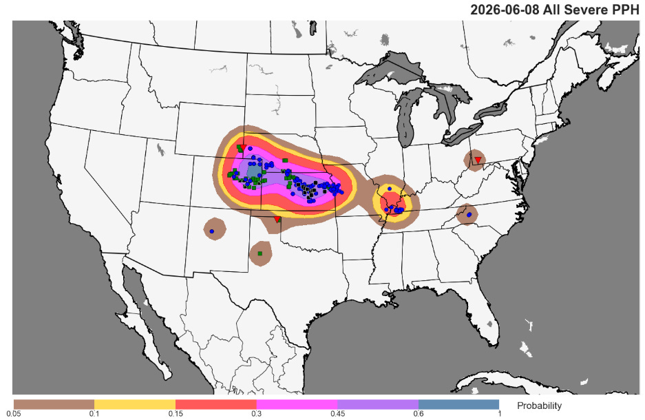
After a relatively quiet last few weeks of severe weather, early to mid June looks as if it will make up for lost time. Monday afternoon and night were quite active across the central US, as supercell severe storms produced very large hail up to 3” in diameter in parts of the Front Range and High Plains, followed by an intense bow echo sweeping east across central and eastern Kansas producing a swath of impressive straight line winds. The official automated observing site at Salina, KS reported a measured wind gust of 113 mph, and more than a dozen significant severe wind gusts (75+ mph) were received by the NWS. Tens of thousands of customers lost power during the height of the event, and significant damage was reported including in Salina.
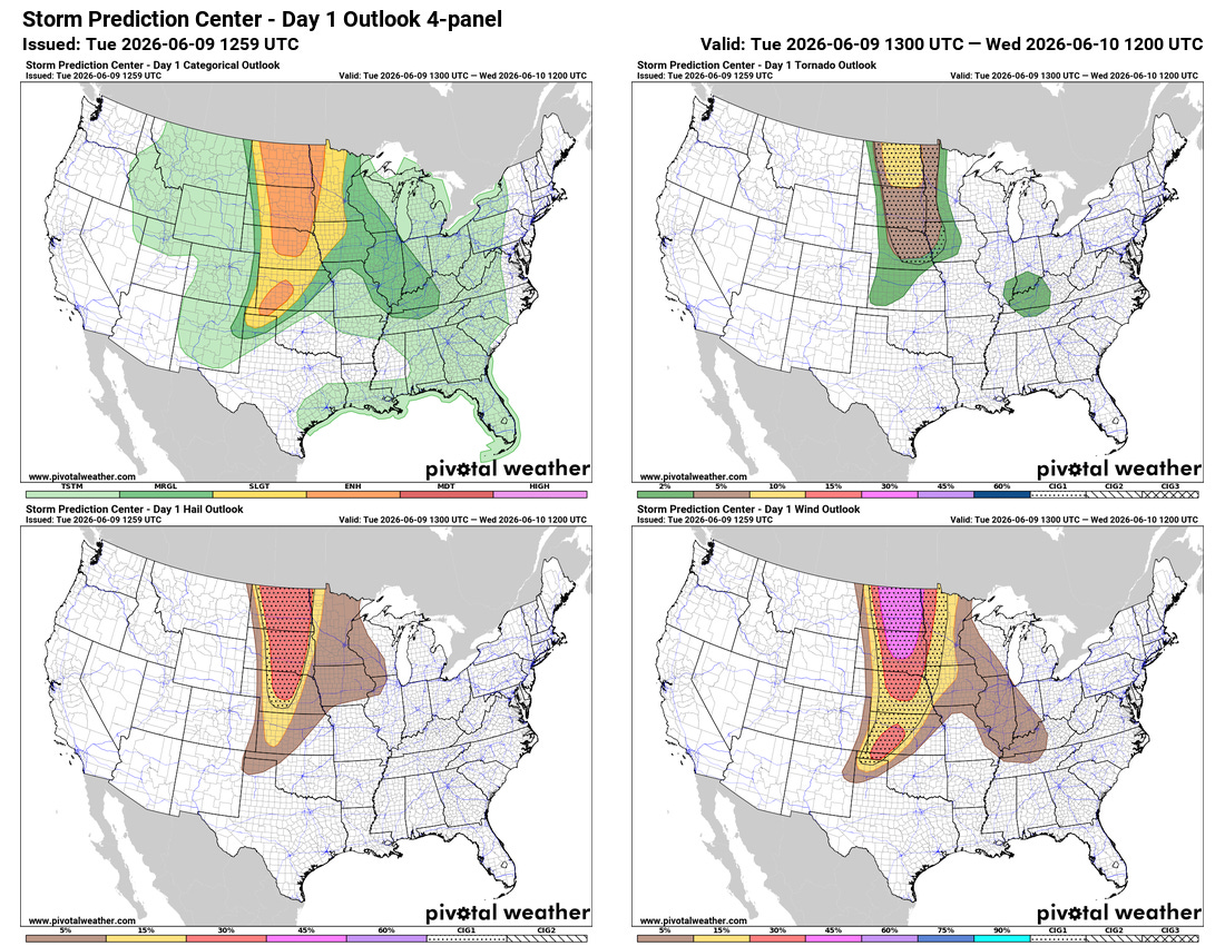
Another very active day is expected across the central part of the country as a strong upper level disturbance ejects northeast into the region and interacts with a very unstable atmosphere, resulting in high-end severe thunderstorm potential across a broad region from Kansas to the US/Canada border (and north into Manitoba). The greatest significant tornado potential looks to be with supercell storms that should evolve in North Dakota — with an even greater risk north of the border. Significant straight line winds are also anticipated as the storms evolve into more linear features and move east tonight. Severe storms will also be possible in the very moist and unstable atmosphere along a warm front extending southeast from this region, with the greatest risk likely in the lower Ohio Valley.
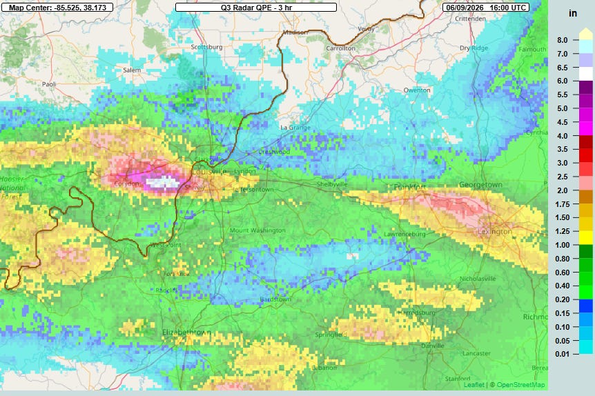
Flash flooding will also be a concern in the lower Ohio and Tennessee Valleys where the Weather Prediction Center has a slight (level 2 of 4) risk of excessive rainfall in place. Torrential rainfall of up to 6” in 3 hours this morning has caused significant flash flooding in the Louisville metro area, with water rescues in progress.
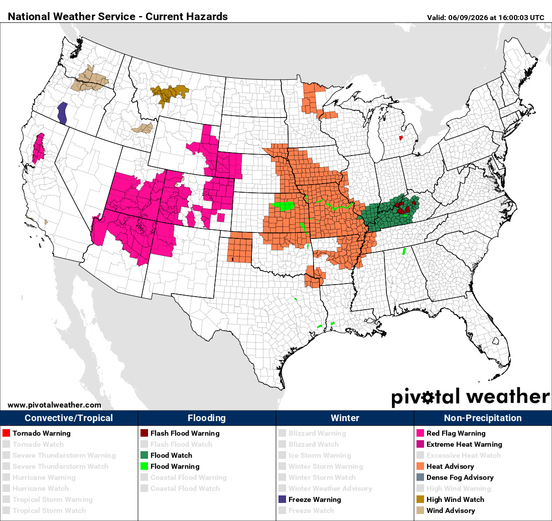
Flash flood watches are in effect from southeast Missouri across much of Kentucky. On the south and southwest side of the upper level disturbance driving the widespread severe weather risk today, dry and windy conditions will continue to support elevated fire danger and Red Flag Warnings are in effect for many areas.
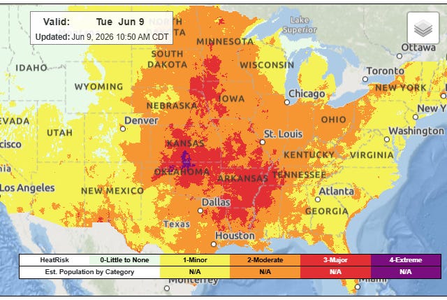
In between the fire danger and flash flood risks, near record heat and muggy conditions will result in widespread moderate to major heat risk, and heat advisories are in effect for many areas as seen in the NWS hazard map above.

Very active severe weather is expected to continue beyond today. On Wednesday as the upper level disturbance moves east, high end severe weather risks including the potential for strong tornadoes, very large hail and significant straight line winds will shift east toward the Upper Mississippi Valley including the Twin Cities region. That disturbance is expected to produce a risk of severe storms in the East on Thursday, while a new disturbance brings a renewed risk of significant severe weather to the Midwest as well (upper right graphic above). Given the high levels of moisture expected, flash flooding will also continue to be a concern as well.
Programming Note: Given the increase in active weather, I have started utilizing the Substack Chat feature again to share occasional updates. I will be utilizing chat and occasional live videos over the next several days — as a reminder, these are benefits that paid subscribers receive for their support of Balanced Weather. Any videos I do will also be recorded and shared to all subscribers.

Leave a comment