Lots of heat and fire danger from Texas across the Rockies
Jun 17, 2026
Happy hump day and welcome to what continues to be a very busy weather period Starting off this morning with the morning complex of thunderstorms impacting the Midwest. As I discussed in last night’s update, trends were hinting that this complex could be stronger and more expansive than earlier anticipated, and that indeed has panned out. The above loop of MRMS radar mosaic with storm reports overlaid (loop courtesy WeatherFront app) shows how this complex produced widespread damaging winds gusts across central Iowa and into central Illinois, including a measured wind gust of 94 mph in Marshall County, IA.
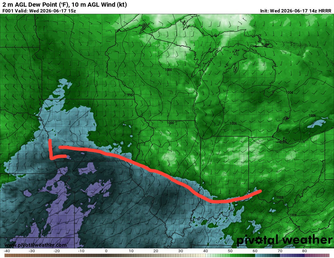
The fact that this complex became stronger and larger means that its cold thunderstorm outflow was even more effective at reinforcing the cool air on the north side of a well defined warm front running southeast across southern Iowa (crudely drawn in above), central Illinois and southern Indiana from an intensifying low pressure center near Omaha. As we have been discussing, that low is unusually strong for mid-June, and as it slides east, a strong southerly low level jet will try to push the warm front north — while the outflow and lingering thunderstorms north of the boundary will try to hold it in place.
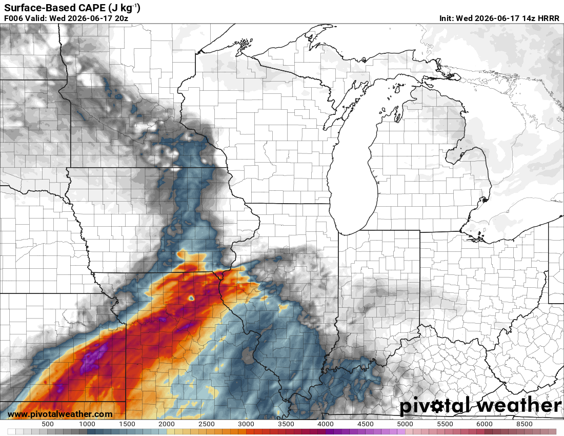
Meanwhile, south and southwest of the warm front strong June heating of a humid airmass will result in the airmass becoming very unstable with convective available potential energy values surging to 3000-4000 J/kg. That highly unstable airmass being transported into this region where the strong low pressure center will be moving in along the warm front will yield an unusually complex and volatile severe weather setup from northeast Missouri across central Illinois into western and central Indiana later this afternoon and into tonight.
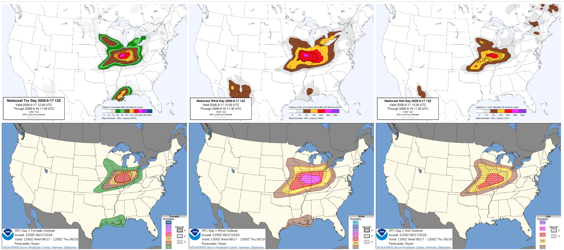
The evolution of this morning’s storms has resulted in the subtle shift to the southwest in the maximum severe weather risk with round 2 of the severe weather later today, with the morning Nadocast AI guidance now focused from the Mississippi River region north of St. Louis east into the southern two-thirds of Indiana. Numerous intense supercell severe storms are expected to develop in this volatile environment, with significant tornadoes, very large hail and 75+ mph wind gusts all possible.
The severe thunderstorms will continue southeast into a less supportive environment — but still with some severe weather risk — overnight. On Thursday, a less volatile but still complex scenario will evolve over the eastern United States with multiple bands of strong to severe storms developing ahead of the cold front driving today’s severe weather as well as Tropical Storm Arthur (more below) approaching the Southeast. Damaging winds and a few tornadoes should be the main risk with the severe storms on Thursday.
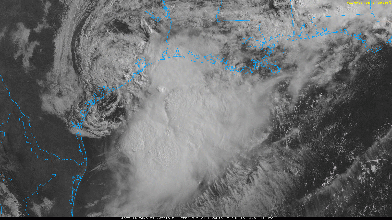
A bit to my surprise, NHC this morning designated the low pressure system along the Texas coast as Tropical Storm Arthur. While it has a quite well developed center in visible satellite and observational data near Matagorda Bay, the thunderstorm activity is well to the east of the center, and any storms that try to develop closer to the center are rapidly being blown east by strong upper level wind shear. However, there is an impressive curved band of thunderstorm activity over the northwestern Gulf east of the center, and data from a Hurricane Hunter reconnaissance flight and surface observations indicated sustained tropical storm force winds of 40 to 45 mph in that band. Given that, NHC has designated the system Arthur.

Arthur is not expected to last long, at least over North America — there are some signs that it could regenerate in a few days over the north Atlantic after it moves off the East Coast. More on that in coming days.
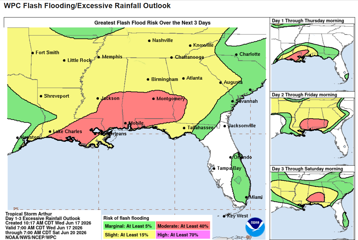
As we have been saying for days, the major risk with this system will be very heavy rainfall and the potential for significant flash and river flooding. While Arthur is not well developed as a tropical entity, it has a rather low (1001 mb) central pressure and strong southerly winds on its east side. Those winds will funnel extreme levels of moisture into the Gulf Coast region, which will interact with an old front and favorable jet stream dynamics to produce numerous waves of showers and storms with torrential rainfall.
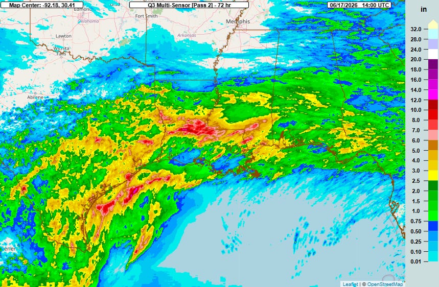
This weather setup has already brought very heavy rainfall and some flooding to the region over the last few days, with a particularly heavy band of 6-12” of rainfall across parts of central Louisiana per MRMS multi-sensor estimates above.
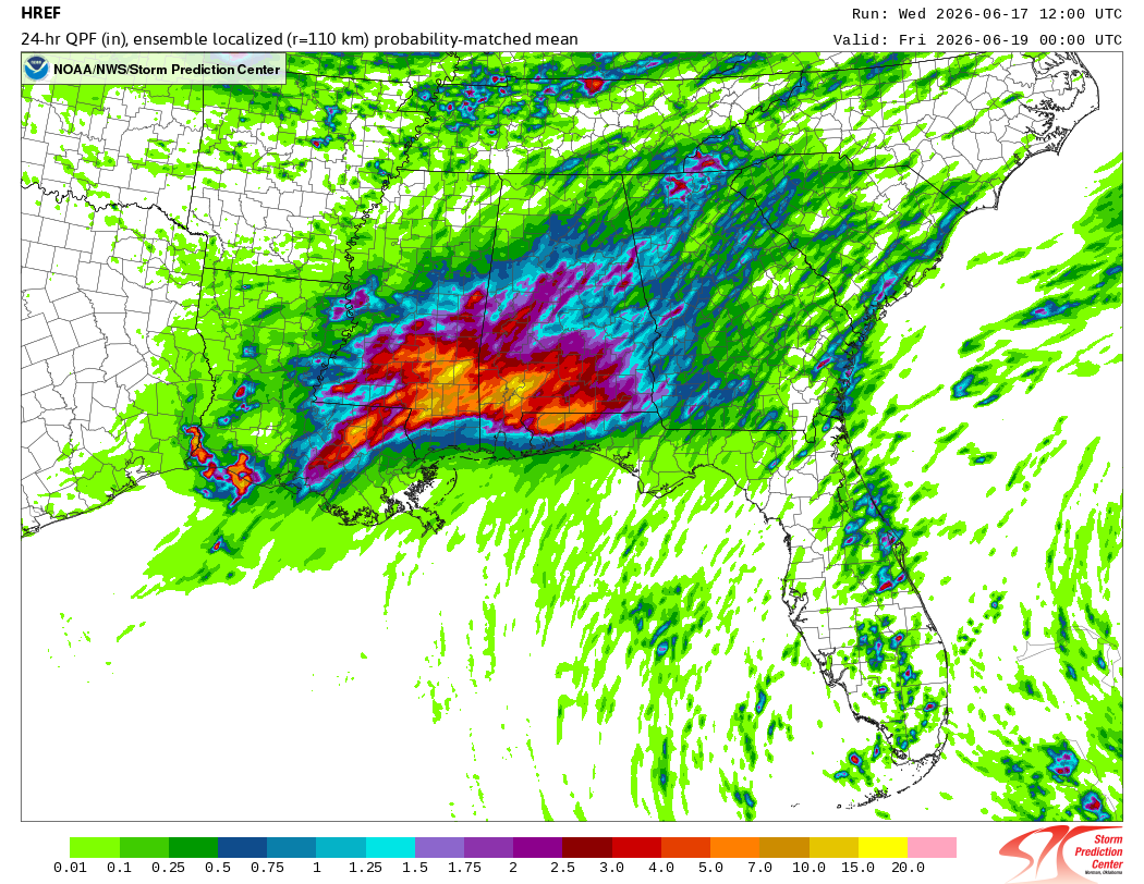
Most of the showers and storms remain offshore this morning, but that will begin to change later today and especially tonight into Thursday as the center of Arthur moves northeast. This morning’s data from the High Resolution Ensemble Forecast (HREF) shows the potential for pockets of 15-20” of additional rainfall through Thursday afternoon across parts of eastern Louisiana, southern Mississippi and Alabama, and the western Florida Panhandle. Obviously, those types of rainfall amounts would produce major, potentially life-threatening flash flooding along with serious river flooding if it falls within a river basin.
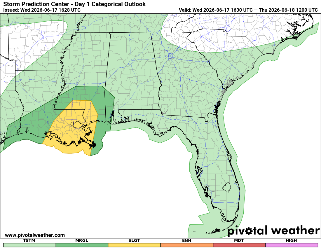
As I have been mentioning, increasing moisture and wind shear will also result in a risk of some shallow, tropical supercell storms along the central Gulf Coast, and the most recent Storm Prediction Center outlook now has a slight (level 2 of 5) risk of severe weather for tonight with tornadoes the primary risk.
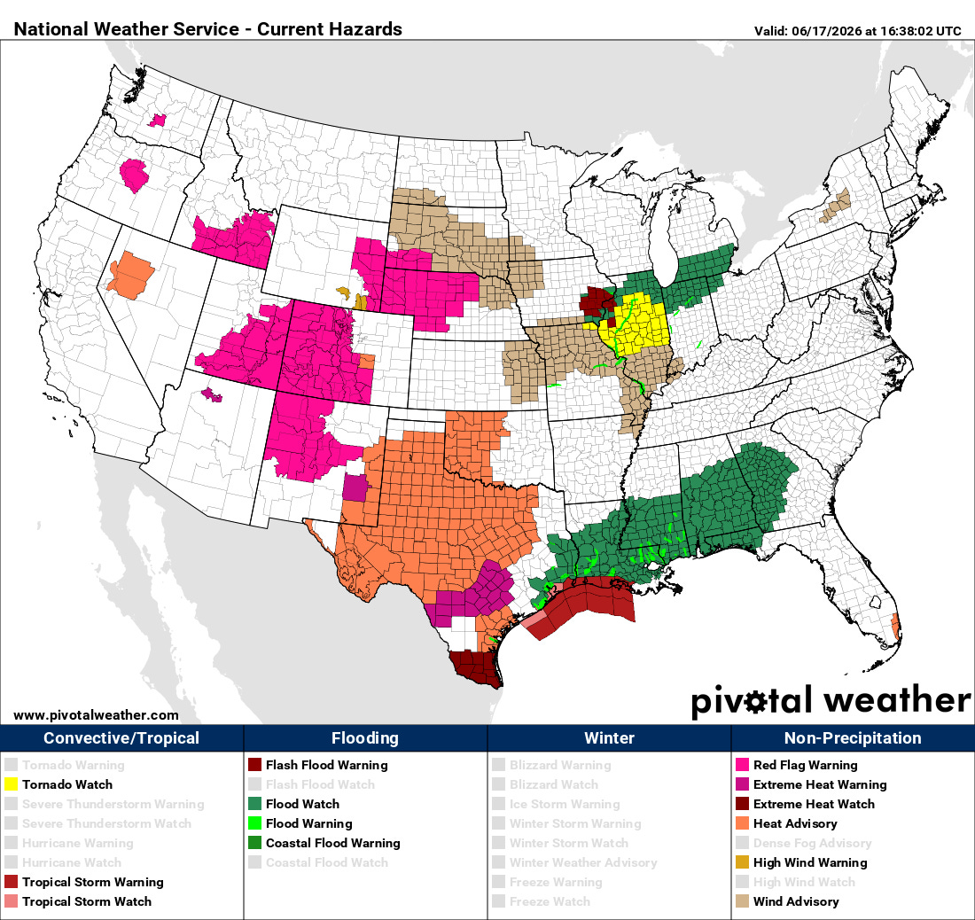
On the west side of all this mess, extreme heat and fire danger are are serious concern today, with extreme heat warnings, heat advisories and red flag warnings in effect for a number of areas as shown above.
I will be working around a medical appointment at mid-afternoon — but otherwise plan on providing frequent updates about all of today’s weather for paid subscribers via Substack Chat and live videos (assuming I get my technical issues sorted out), and on BlueSky and Facebook. Any videos I do will be shared with all subscribers as soon as they can be processed.

Leave a comment