Nearly 20″ of rain in 6 hours measured in central LA; tornadoes also a risk today, with severe storms also possible along the East Coast
Jun 18, 2026
This morning is one of those days where there is so much going on I literally do not know where to start. Before I dive into the major impact weather, I wanted to share this breaking news from the New York Times (gift article) that the Trump Administration is backing down from plans to dismantle the National Science Foundation’s Ocean Observatories Initiative after a bipartisan bill was passed in the U.S. Senate yesterday to prohibit the administration from making any changes to the OOI system.
I had not really written about this particular push by the administration to terminate a science program because I am not familiar with the OOI and I have plenty of other ongoing situations that I am familiar with – and because to be honest I have received mixed information from colleagues about exactly how impactful cutting the OOI would be, at least to weather and climate operational applications. Having said that, it seems clear the Congress was very unhappy with the idea of closing down an ocean and climate change monitoring system that has had hundreds of millions of dollars invested in it just when we are on the threshold of a potential record El Nino event.
From a broader perspective, this tangible bipartisan pushback from Congress indicates to me that Republican tolerance for the administration’s cuts to science programs is waning. It will be interesting to see how this is reflected in the ongoing development of FY2027 appropriations bills for entities like NOAA and NSF.
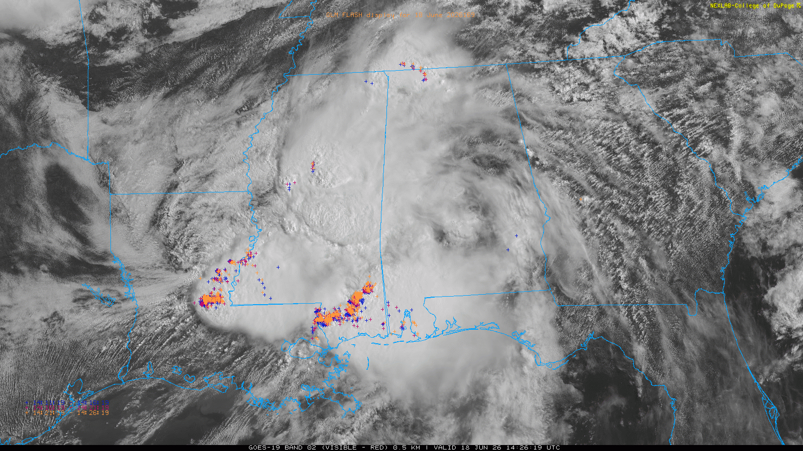
We have already seen some incredible high impact weather this morning, with serious flash flooding and a number of tornadoes in parts of the central Gulf Coast region associated with the remnants of Arthur. This incredible GOES visible satellite loop with GOES Lightning Mapper (GLM) lightning data overlaid shows not only the two major areas impacted — one over central Louisiana and the other the Northshore New Orleans metro up into southeast Mississippi — but also the atmospheric processes happening.
In the western area, the center of the low pressure associated with Arthur is moving very slowly over northeast Louisiana, and to its south there is a persistent band of convergent air. We can actually see bands of cumulus clouds converging into the band and feeding into the complex of storms that is centered near Simmesport, LA.
Incredible rainfall totals of up to 20” in less than 12 hours have occurred in this area. A Citizen Weather Observer Program site just west of Simmesport reported 19.74” of rain in the 6 hours ending at Noon CT, and the USGS gage on the Atchafalaya River at Simmesport had 11.82” in 6 hours.
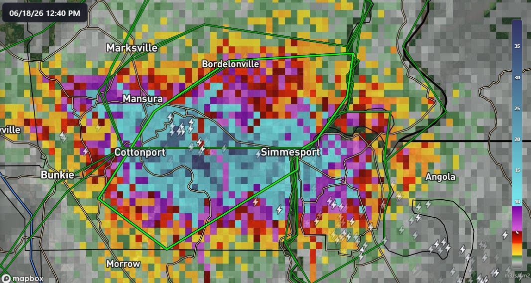
The MRMS FLASH unit streamflow inundation product shows some of the highest values I have ever seen — values of 10 indicate significant flash flooding, and there are maxes near 40 here. This is a relatively rural part of central Louisiana, but for residents and people traveling in the area, this is an extremely dangerous, life threatening flash flood event.
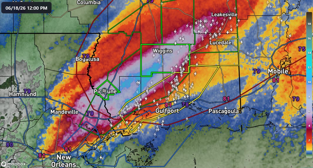
The other area being heavily impacted this morning is much more heavily populated. A swath of 6-12” of rain in 6 hours fell from the west side of New Orleans across the North Shore and into Southeast Mississippi. Major flash flooding appears to have occurred in the Slidell, LA area as well as Picayune, MS — and a flash flood emergency was recently issued for Stone County, MS including Wiggins.
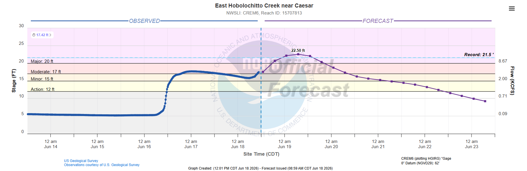
The East Hobolochitto Creek that runs along the south side of Picayune, MS is now forecast to reach a record stage, surpassing by a foot the prior record set during Hurricane Isaac in 2012. This result in significant flooding impacts to homes and structures along the creek, as well as flooding of Mississippi Highway 43.
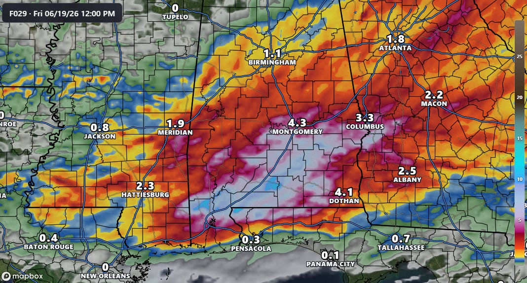
This event is nowhere near done, as waves of very heavy rainfall are expected to continue across southeast Mississippi and parts of Louisiana this afternoon, and continue to expand east into southern Alabama, the western Florida Panhandle and parts of Georgia through Friday morning. As I have been emphasizing, while we cannot predict the exact locations where they will fall, the high resolution models are giving clear signals that these extreme rainfall totals of a foot (or more) in 6-12 hours are likely in spots where storms stall out and train for a period.
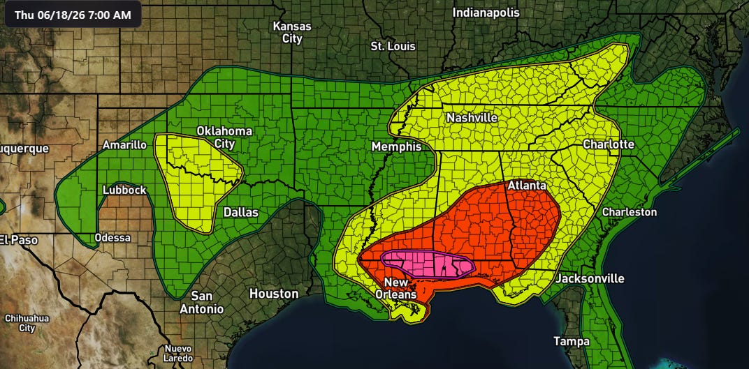
Catastrophic, life threatening flooding will be possible in these areas., and the NWS Weather Prediction Center has moderate (level 3 of 4, red above) and high (level 4 of 4, purple) risk areas in place through tonight.
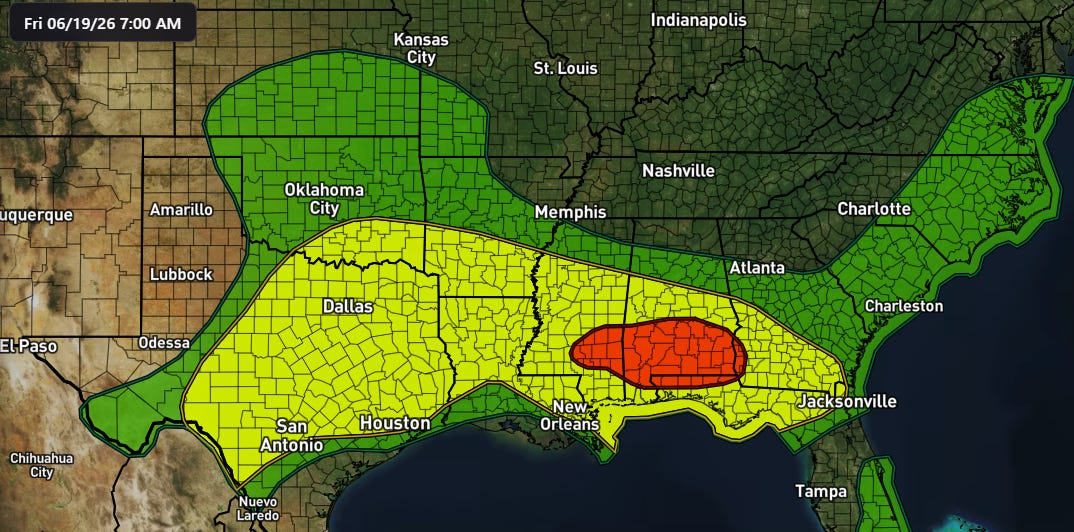
The risk will continue into Friday as the tropical moisture interacts with a stalling cold front as well as the remnants of Arthur pushing across the Southeast.
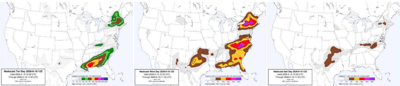
As we have been discussing the last couple of days, the overall weather setup and the AI guidance were suggesting a risk of tornadoes as well with tropical supercell storms along the Gulf Coast, and there have already been several radar confirmed tornadoes across the region this morning, including ones in Louisiana that caused damage in the Northshore region near Slidell and another in New Orleans. The risk of severe weather and tornadoes will shift expand east through the day as shown in the Nadocast tornado probabilities in the left hand graphic above.
Severe weather will also be a risk along the East Coast today, with bands of storms potentially producing damaging winds (middle graphic above). Tornadoes will also be possible across parts of upstate New York and New England with potential supercell storms in this area. Severe storms will also be possible across parts of the Southern Plains, as high based storms in a very hot environment could produce some isolated significant downburst winds.
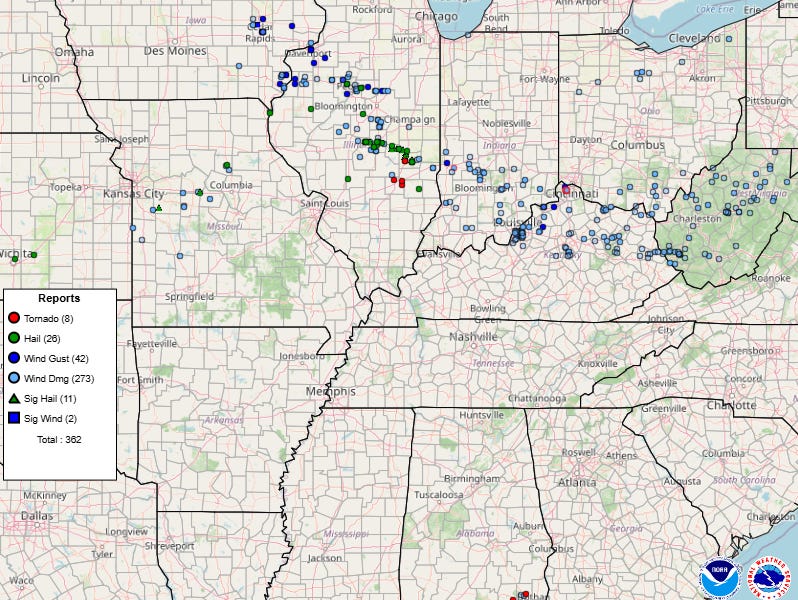
There is so much to say about yesterday’s severe weather that there is not time to go into right now. As expected, there was a tremendous number of supercell severe storms that erupted across northern Missouri and central Illinois and moved east-southeast across Indiana and eventually became more of a line of storms that produced widespread damaging winds across the Ohio Valley and central Appalachians. A number of significant tornadoes occurred, including longer track tornadoes near Effingham, IL and Gosport, IN. Fox Weather reports that Interstate 69 remains closed due to the Gosport tornado — I do not know why that tornado and others across southern Indiana are not on the NWS report map because there were clear tornadic debris signatures with them. Regardless, these were highly impactful storms with many heavily damaged communities, and NWS will be conducting numerous damage surveys in coming days.
Graphics in today’s post not from NOAA websites are courtesy of the WeatherFront app.
Programming Note: Given the increase in active weather, I have started utilizing the Substack Chat feature again to share real-time updates. I will also be doing some live videos over the next couple of days to provide briefings and updates about the evolution of severe weather and flash flooding risks. As a reminder, these are benefits that paid subscribers receive for their support of Balanced Weather. Any videos I do will also be recorded and shared to all subscribers. I also provide updates on my BlueSky and Facebook feeds, and via occasional Substack Notes. To see an example of my Substack chat updates from the Thursday night severe weather in the Midwest, click here.

Leave a comment