More severe weather and flash flooding anticipated in central US this weekend
Jun 19, 2026

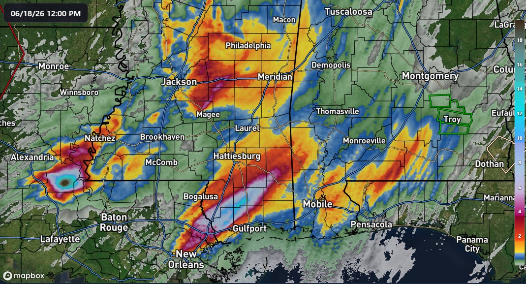
Thunderstorms producing tremendous rainfall rates moved through large parts of the South over the last 48 hours causing flash flooding. Where storms slowed and trained over areas for several hours, incredible amounts of rain fell in a relatively short period of time, causing catastrophic, life-threatening flash flooding.
Areas of the Mississippi Gulf Coast were particularly impacted Thursday, with dozens of people having to be evacuated by boat from areas around Perkinston, MS in Stone County, just inland from the coast. Flooded homes were reported in Hancock County and water rescues in Jackson County on the coast.
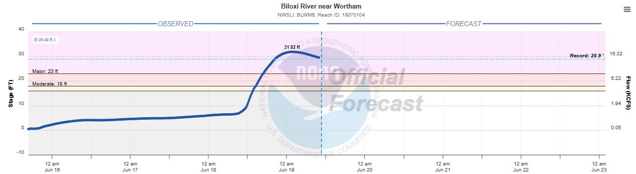
The Biloxi River at Wortham, MS crested early this morning nearly 2 feet above its prior record, set during the historic early May 1995 central Gulf Coast flood event.
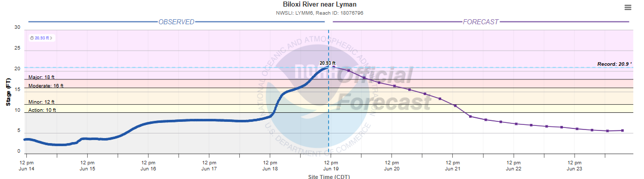
The downstream gage on the Biloxi at Lyman just exceeded its May 1995 record as well (records go back at least 60 years). According to NWS flood impact statements, numerous subdivisions and structures are impacted by flooding when the Biloxi River reaches these levels.
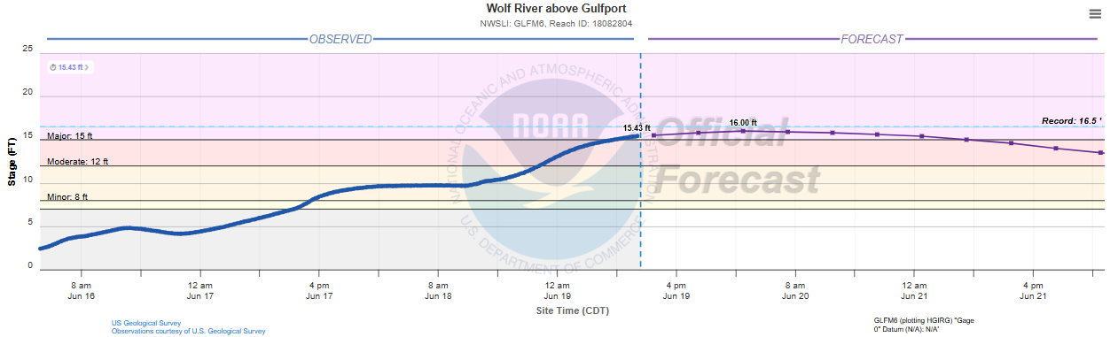
Just to the west, the Wolf River at Gulfport has also exceeded its 1995 flood, and is now just below the record level set in 2012 during Hurricane Isaac. Numerous homes are also likely being flooded along the Wolf River as well.

Farther west in Avoyelles and Pointe Coupee parishes in central Louisiana, relentless storms with 5” per hour rainfall rates dumped more than 20” of rain in about 6 hours Thursday, causing catastrophic flash flooding. Numerous water rescues and evacuations were needed here as well. Corneice Watson in Simmesport, LA told WAFB-TV that her house is “literally gone. The water is so tall we can’t even get to our house.” More than 200 homes were flooded in Avoyelles Parish.
A point that I want to stress is that much of the media coverage I am seeing is focused on all of this being caused by Tropical Storm Arthur, which of course is true. But all of these impacts would have happened regardless if Arthur had “become” a tropical storm or not. Arthur as a tropical entity was a pretty disorganized mess and its low pressure system was the result of both tropical and non-tropical atmospheric processes. The thunderstorms that caused the flooding over central Louisiana were directly associated with Arthur’s remnant low pressure system; the thunderstorms farther east were a result of a strong low level jet of southerly winds transporting tremendous moisture north and interacting with a front and upper level atmospheric dynamics from the jet stream to the north of the area.
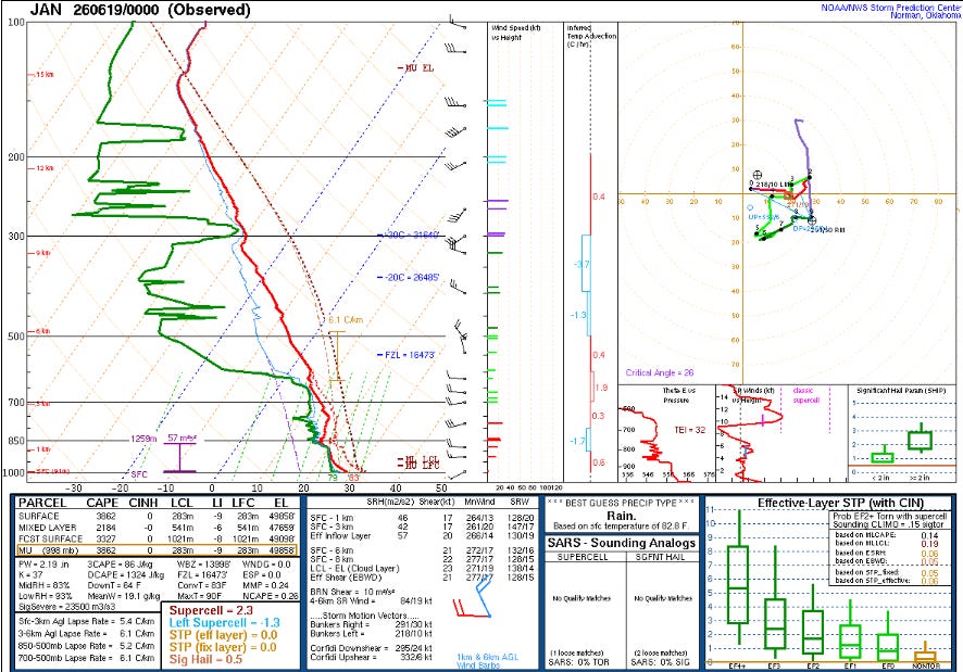
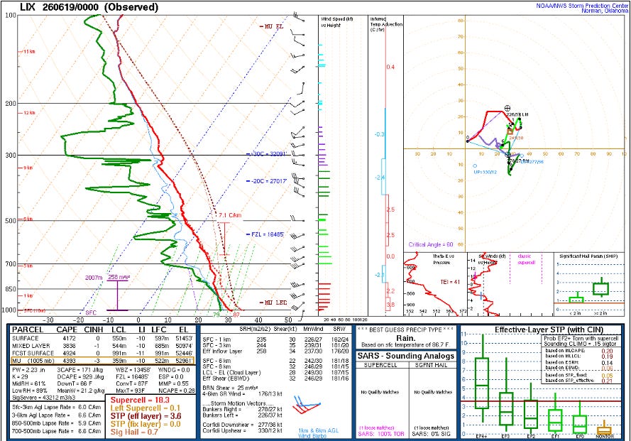
Upper air balloon data from last evening at Jackson and Slidell reveal what was truly noteworthy about this weather setup: the extreme values of both moisture and instability. The precipitable water (parameter that integrates moisture over the depth of the atmosphere) values at both sites were at record high levels for the date per the SPC sounding climatology webpage. Often when moisture levels are that high the atmospheric instability is not — but in this case, both soundings are quite unstable. This not only allowed for very efficient rain producing storms with MRMS instantaneous rainfall rates at times showing 7” per hour rates, it also allowed these storms to produce quite a bit of severe weather (more on that below).
The 12-24” of rainfall that caused all of this flooding didn’t fall in a matter of days or even a day, it fell in a period of several hours. If the 23.35” rainfall report at the CWOP site at Plaucheville, LA is verified, it will set a new 24-hour rainfall record for the state of Louisiana. Nearly all of this rain fell in only 6 hours. Flash flooding is not just about rainfall amounts, it is about rates — and rates like this are what cause streams and infrastructure to be overwhelmed rapidly and put people in life-threatening situations as we saw on Thursday. Luckily, based on media reports it seems as all of the water rescues were successful and no fatalities have been reported.
Increased atmospheric moisture is one of the most obvious and well understood implications of climate change, and it does not only impact rainfall, it impacts temperatures and human health. Surface dewpoint values of 80F were relatively rare a century ago, but have been becoming increasingly common as our climate has warmed. I took a look at a couple of observing sites in Mississippi and the trend is clear. For example, at McComb, MS 80F dewpoint days were only observed twice in the 30 years prior to 1976. In the 50 years since, they have been observed on 105 days, including on 85 days in the last 30 years.
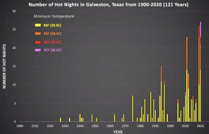
Higher near surface atmospheric humidity results in warmer overnight low temperatures, and the numbers of record warm minimum temperatures has been growing dramatically in recent years. That trend has been particularly notable in areas along warm bodies of water like the Gulf of Mexico. The graph above shows the number of “hot” (morning low of 84F or higher) nights at Galveston. While there is certainly some natural variability which I also could see in the dewpoint data at the sites I looked at in Mississippi, the overall trend is clear.
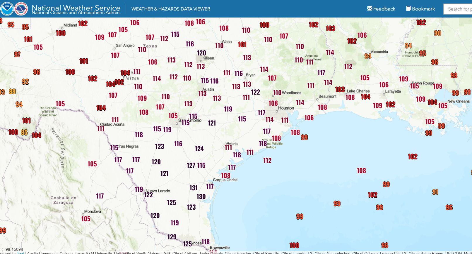
Obviously, all of this also results in a trend toward higher heat index values — and yesterday was an incredible example of this. Numerous locations in Texas saw heat index values top out above 120F with a few sites even creeping to 130F — the observing site at McAllen, TX reported a heat index of 129F at 3 pm (101F temperature, 83F dewpoint).
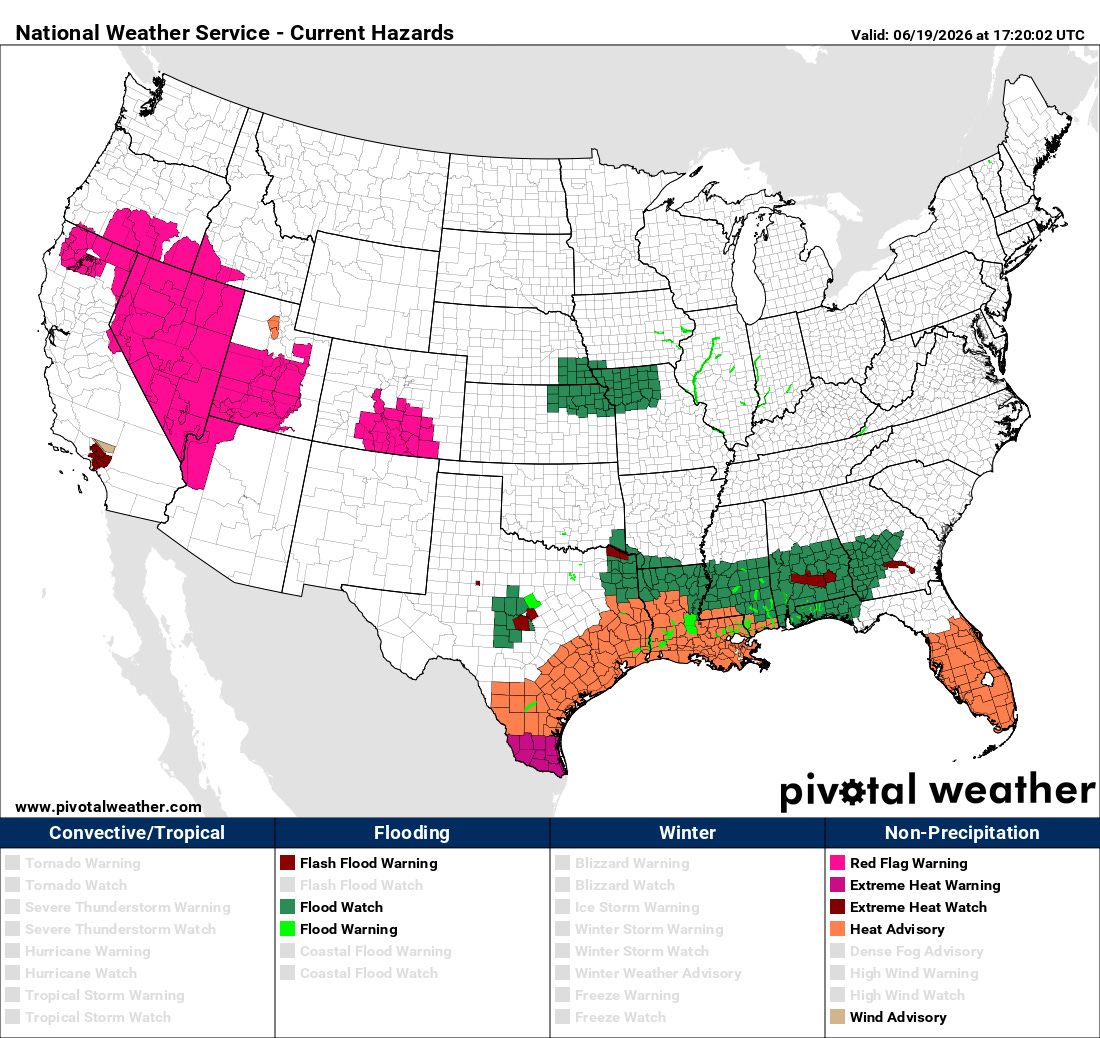
While extreme heat index values will not be as widespread over Texas today, heat advisories are in place for much of the western and central Gulf Coast, with extreme heat warnings in effect for Deep South Texas. Excessive heat and humidity have also been plaguing Florida, where heat advisories are in place as well today. Fire weather is a significant concern in the West today, as high based dry thunderstorms and breezy conditions are expected to raise wildfire concerns with red flag warnings in effect.
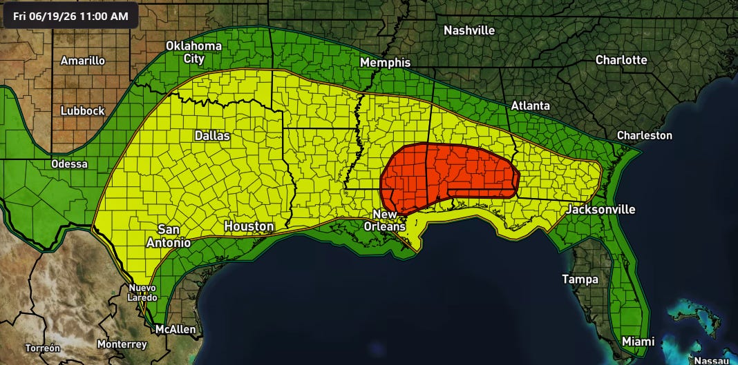
Flash flooding will also continue to be a risk across the south today as thunderstorms will continue to develop in the lingering high levels of moisture and instability as a cold front slowly sags into the area. The flash flooding risk will be highest in the areas that saw the heaviest rainfall on Thursday and ground conditions will not allow much absorption of new rainfall.

A few severe thunderstorms will be possible in the South today as well after Thursday saw a number of tornadoes and reports of wind damage from south Louisiana across the Southeast. Georgia was particularly impacted with nearly 70,000 customers without power at the peak last evening. Another band of severe storms impacted the Northeast, producing a number of reports of wind damage and knocking out power to at least 150,000 customers (all power outage reports from PowerOutage.us).
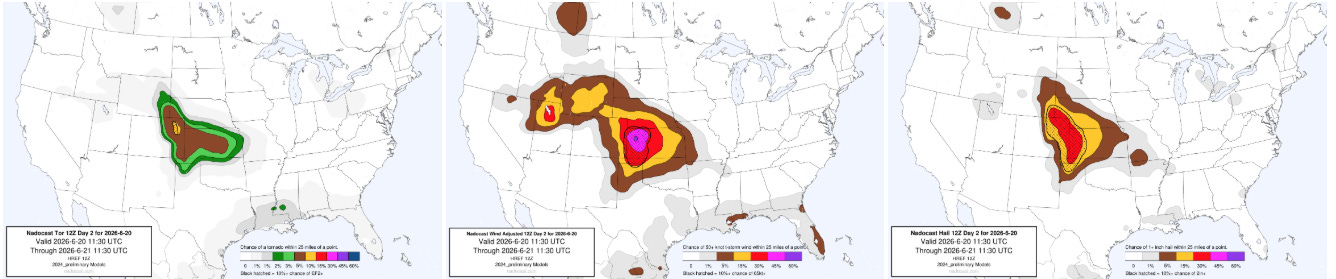
The risk of severe weather will shift back into the central United States on Saturday as moisture and instability will move back north, and an upper level disturbance will trigger supercell severe storms that seem likely to produce very large hail and potentially some tornadoes, particularly in eastern Colorado. As the storms become more of a squall line, the risk for significant straight line wind damage will increase across western Kansas and nearby areas.
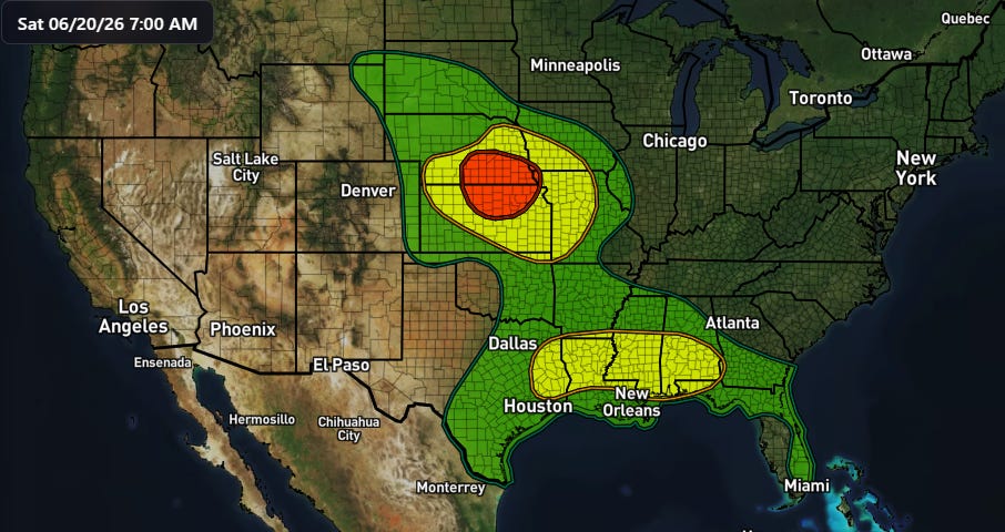
Flash flooding risk will also increase across the central United States on Saturday and Saturday night, with a moderate (level 3 of 4) risk of flash flooding in place from the NWS Weather Prediction Center.
Graphics in today’s post not from NOAA websites or otherwise noted are courtesy of the WeatherFront app.
Programming Note: Given the increase in active weather, I have started utilizing the Substack Chat feature again to share real-time updates. I will also be doing some live videos over the next couple of days to provide briefings and updates about the evolution of severe weather and flash flooding risks. As a reminder, these are benefits that paid subscribers receive for their support of Balanced Weather. Any videos I do will also be recorded and shared to all subscribers. I also provide updates on my BlueSky and Facebook feeds, and via occasional Substack Notes. To see an example of my Substack chat updates from the Thursday night severe weather in the Midwest, click here.

Leave a comment