Central US braces for another round of severe weather and flash flooding this weekend
Jun 20, 2026

Today is #ShowYourStripes day, the day when the weather and climate community tries to raise awareness about global warming using the “stripes” graphics developed by British climate scientist Ed Hawkins. These graphics are intended to simply communicate the trend of global temperatures over the last two centuries. #ShowYourStripes day is on June 20 each year, timed to coincide with the summer solstice, which this year will occur at 4:24 am ET tonight.
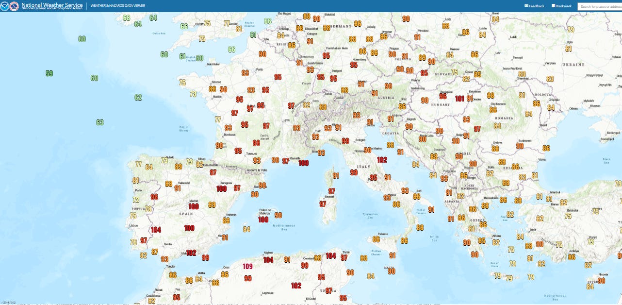
You can peruse my newsletter from this day last year that focused on the origin of #ShowYourStripes and global warming. This year the atmosphere is putting on a rather impressive performance to coincide with the solstice. Europe is suffering through another serious prolonged heatwave, as today temperatures surged into the 90s across much of the continent, with 100s in parts of Spain and coastal France.
Climatologist M. Herrera noted on his excellent BlueSky account that a number of sites in France set June monthly records this afternoon. This comes after he reported that Friday saw numerous June records set across France, including 101F (38.4C) at Paris Luxembourg Gardens.
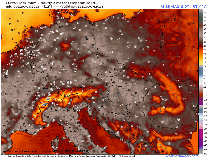
Unfortunately, these last few days are just the start of what is expected to be a period of record heat will last most of next week. Temperatures are expected to rise in the 35 to 40C (95 to 105F) range across large parts of Europe.
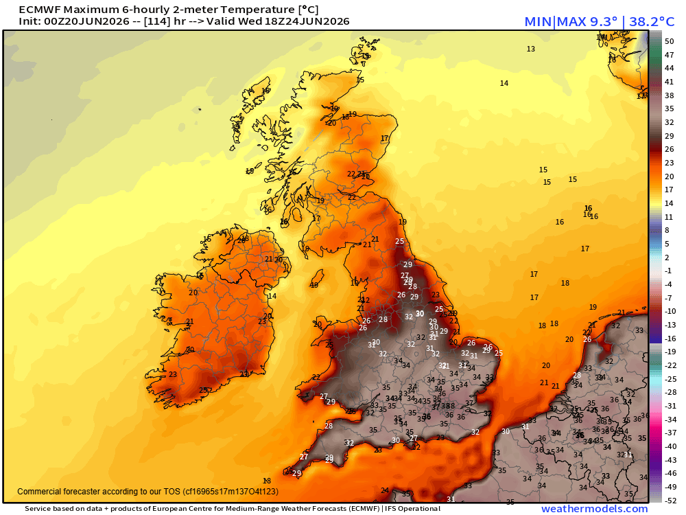
The UK will get into the act as well, with maximum temperatures expected to rise in the 30s Celsius across much of England by Tuesday and Wednesday, with the potential for areas around London to approach 100F. Amber heat warnings have already been issued by the UK Met Office for early next week, as it warns that “some locations could see temperatures above 30C (86F) for six or seven consecutive days, with overnight temperatures remaining above 20C (68F) in places.”
The BBC notes in their article about the impending heat wave in the UK that “the Met Office says heatwaves are becoming more frequent and more intense globally due to human-induced climate change. Scientists project that hot spells will become more common in our changing climate, particularly in the south-east of the UK, saying it is ‘virtually certain that human influence has increased the occurrence and severity of extreme heat events.’” As a reminder, air conditioning is much less common in Europe than in the United States, hence these prolonged heat waves pose an even more serious threat to human life.
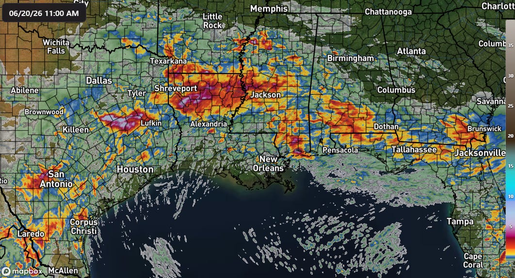
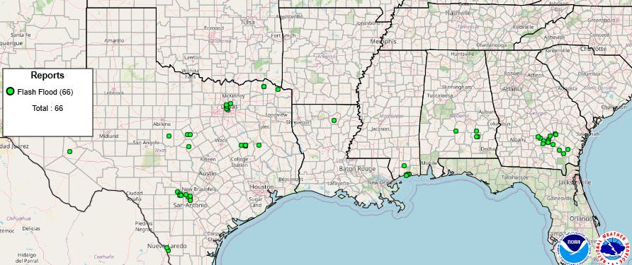
Meanwhile, the southern US continues to deal with intense rainfall and flash flooding fueled by the unusual levels of moisture across the region (e.g, Jackson, MS has now had 6 consecutive upper air balloon soundings back to Wednesday evening with very high precipitable water values of 2” or greater). Thunderstorms with high rainfall rates left swaths of heavy rainfall where they trained over the last 24 hours, with some of the heaviest over east Texas where MRMS 24 hour multi-sensor estimates approached 10”. Numerous reports of flash flooding were received across the southern US by the NWS.
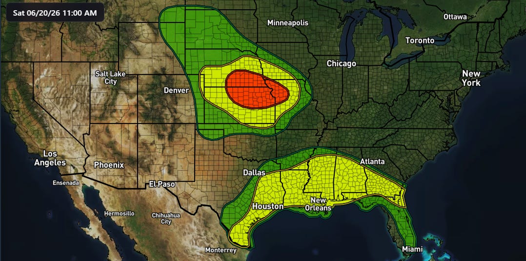
Along with the continued risk of flash flooding and heavy rain in the South, this afternoon and tonight will also see a moderate (level 3 of 4, red in map above) risk of flash flooding across the Mid-Missouri Valley region as an upper level weather disturbance moving east across the Rockies will bring a focused risk for training thunderstorms with heavy rainfall.
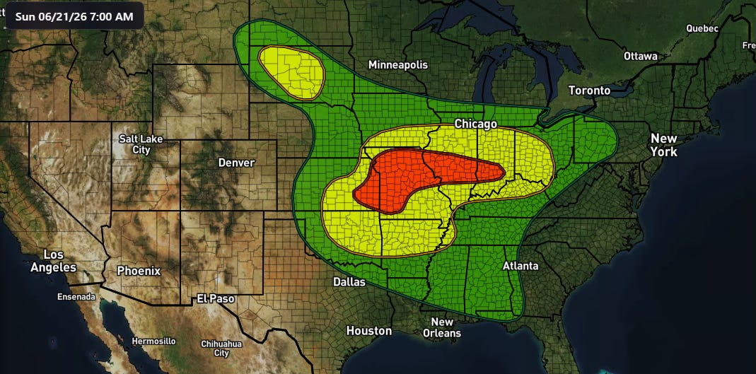
As the weather disturbance shifts east Sunday, the moderate risk will shift east to include the Mid-Mississippi valley.
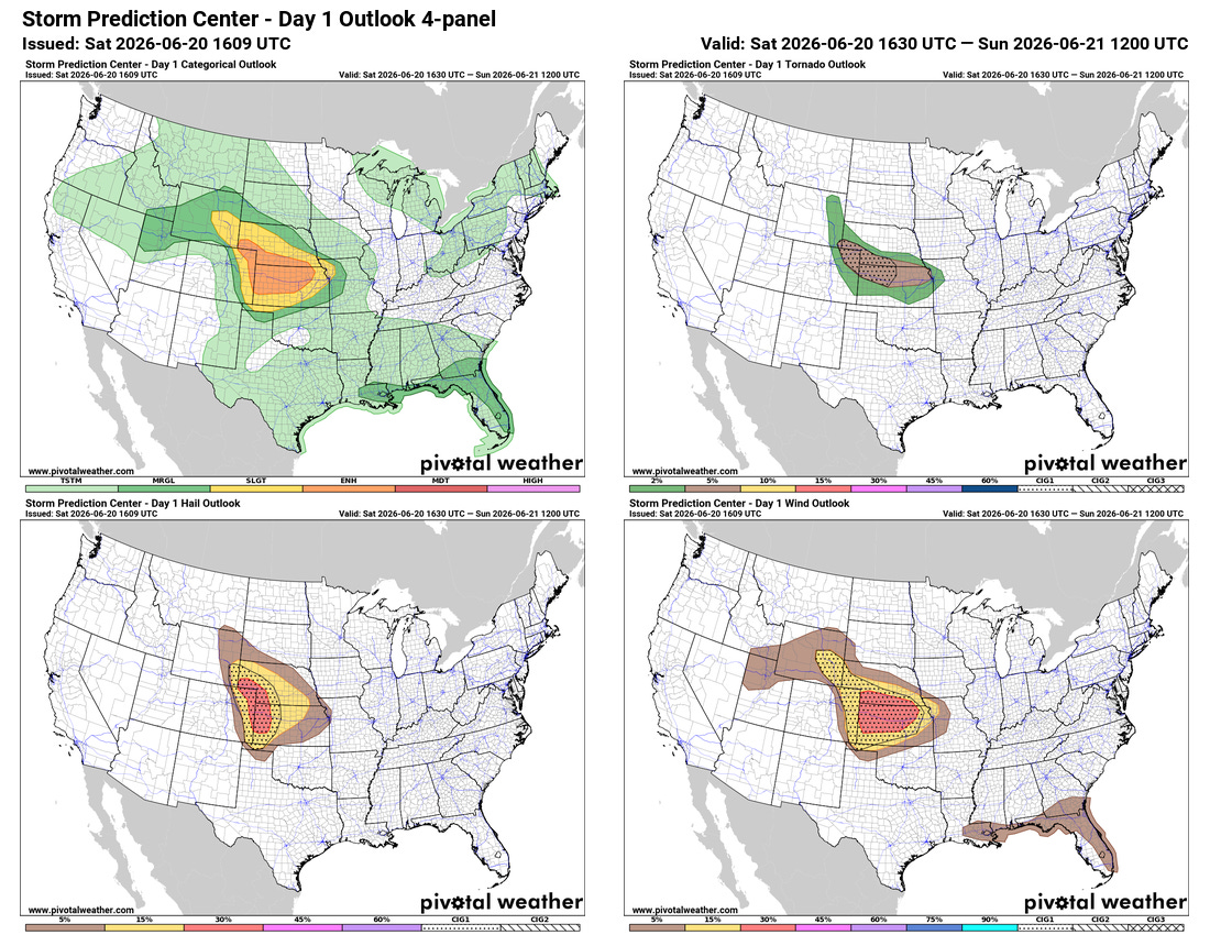
Severe thunderstorms will also be a significant concern with this system, with supercell storms expected to develop late today in the central High Plains with a risk of very large hail and some tornadoes. As these storms evolve and eventually form into a line of severe storms later tonight, they should spread east and southeast with an increasing risk of significant straight line damaging winds across Kansas and southern Nebraska.
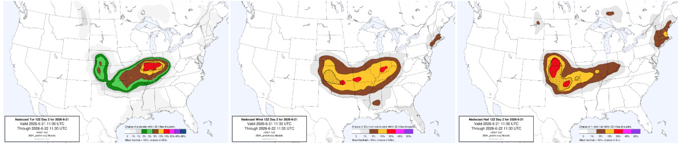
Severe weather will continue to be a risk with this system on Sunday. The magnitude and location of the severe weather risk will be modulated by the evolution of storms tonight into early Sunday — but high resolution models suggest the potential for some higher end severe storms including tornadoes and significant straight line winds. Right now the Nadocast AI probabilities show the most focused tornado risk along the I-70 corridor from St. Louis to Indianapolis — but that risk will likely evolve a bit as we get a better handle on thunderstorm evolution. The bottom line is that folks from the Front Range east to the Ohio Valley should be keeping an eye on later forecasts with regard to the evolving severe weather and flash flood risk.
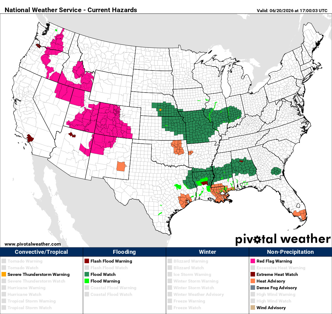
In the West, Red Flag Warnings continue for many areas as fire danger remains high and wildfires continue to ignite and grow across many states. A hot and mostly dry period is anticipated for much of the West into next week.
Programming Note: Given the ongoing active weather, I am utilizing the Substack Chat feature to share periodic real-time updates. I also do occasional live videos to provide briefings and updates about the evolution of severe weather and flash flooding risks. As a reminder, these are benefits that paid subscribers receive for their support of Balanced Weather. Any videos I do will also be recorded and shared to all subscribers. I also provide updates on my BlueSky and Facebook feeds, and via occasional Substack Notes.

Leave a comment