American Meteorological Society issues statement regarding OMB’s proposed federal grant rule changes
Jul 02, 2026
Before I get into the ongoing impact weather around the globe, I wanted to highlight that the American Meteorological Society yesterday released its summary comments on the Office of Management and Budget’s proposed rule changes governing federal science grants. I wrote about these proposed changes and my concerns about them a month ago, and the AMS raised similar and other very valid concerns in their comments that I encourage you to read. As a reminder, public comments on the proposed rule changes are open until July 13, and you can provide input here.
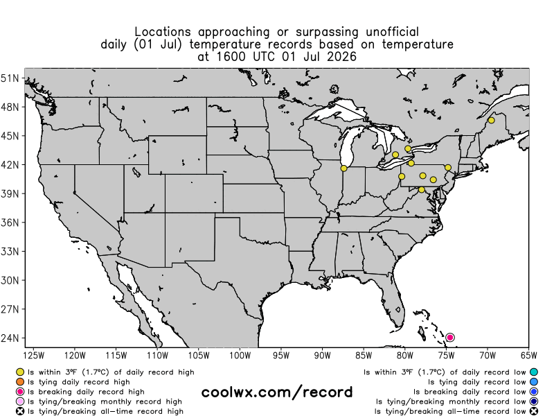
Wednesday saw the Eastern heatwave kick into a higher gear, as numerous daily record warm temperatures (maximums and minimums) were set across the northeast quarter of the country. This included new record highs at Cleveland (97F), Toledo (99F), Syracuse (96F) and Washington-Dulles, DC (97F). As expected, the record warm minimums were even more widespread, and included 80F at Chicago O’Hare, 75F at Buffalo, 78F at Milwaukee, 79F at Madison, WI, and 77F at South Bend (broke prior record by 3F). NYC Central Park reported a low this morning of 82F which would tie a record for the date and be tied for a top 10 warmest morning on record. The extreme warmth is of course not stopped at the border, and climatologist M. Herrera reported that Sarnia in southwest Ontario set an all-time record warm minimum with 26.8C (80F) on Wednesday.
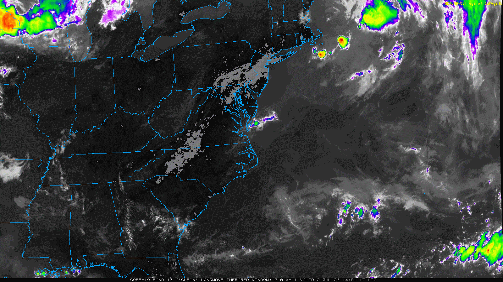
The morning infrared satellite loop interestingly shows where the strongest heating is occurring this morning, as the expanding gray areas indicated where the satellite is measuring building surface heat.
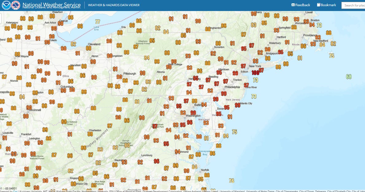
Temperatures are running several degrees hotter today than 24 hours ago, with JFK and Newark airports already reaching 100F before Noon ET.
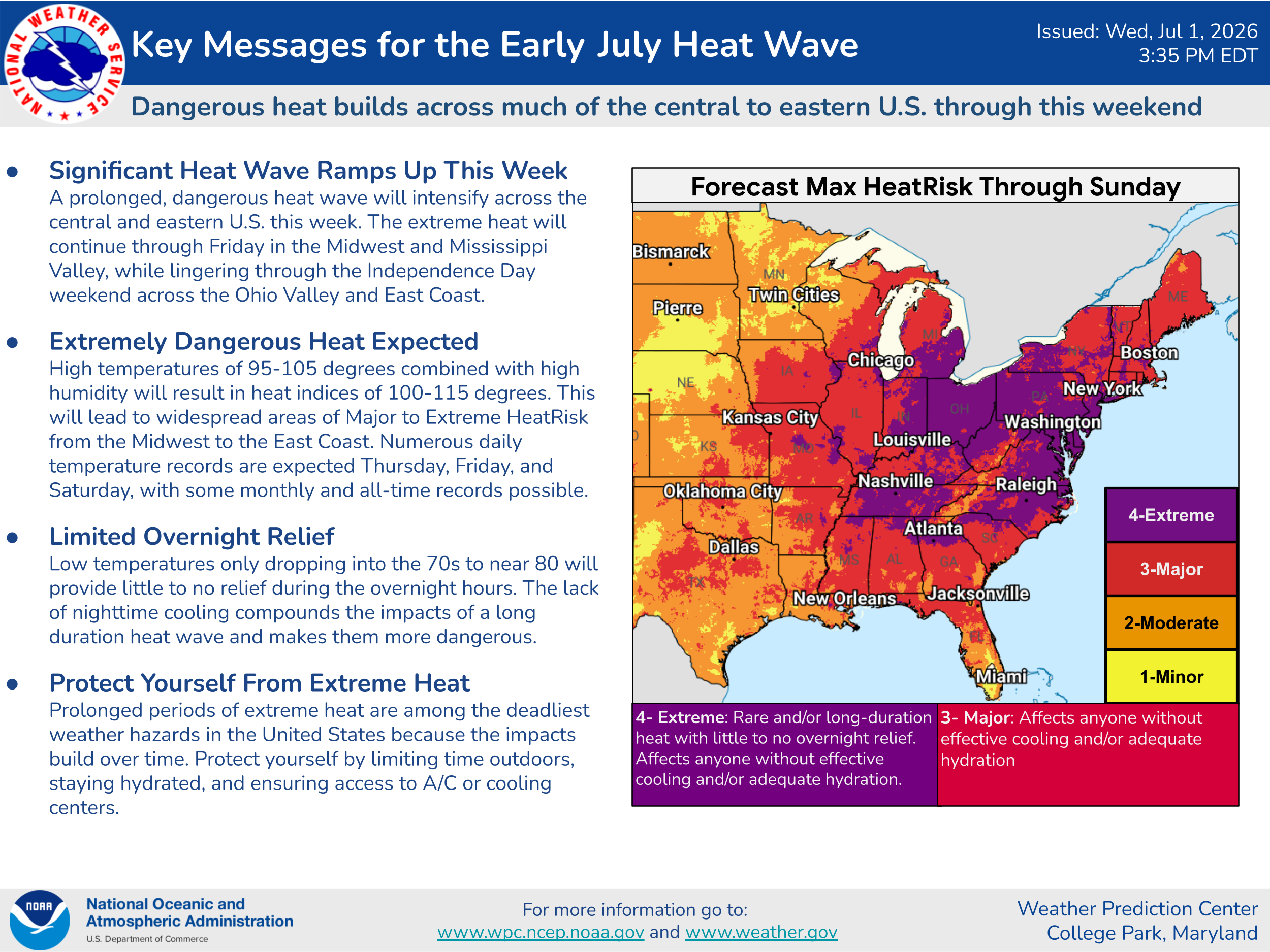
The overall impacts from this extended heatwave are still pretty well on track, and well summarized in this key messages graphic from the Weather Prediction Center.
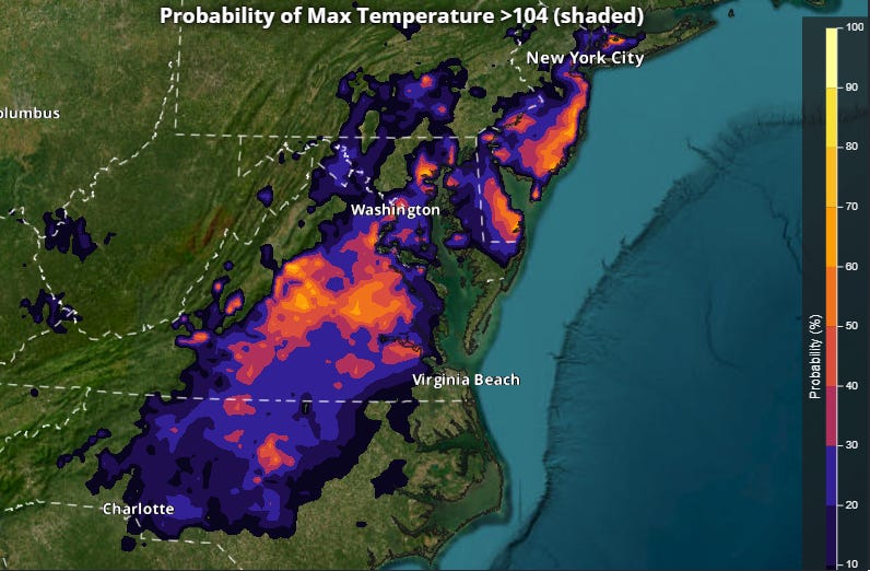
Friday still appears as though it will be the peak day of the heatwave as the upper level high pressure dome will start to erode into the weekend. Probabilities from the NWS National Blend of Models (NBM) ensemble continue to show meaningful probabilities of high temperatures of 105F or greater along the I-95 corridor, which could set monthly records and approach all-time record highs in some locations.
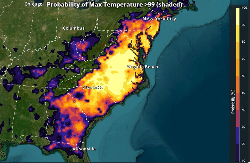
While Friday will be the peak, there will not be a strong front moving through the region east of the Great Lakes, and the trend toward “cooler” weather will be gradual. High probabilities of temperatures 100F or higher will continue on the Fourth of July all along the East Coast from NYC to the Florida Panhandle.
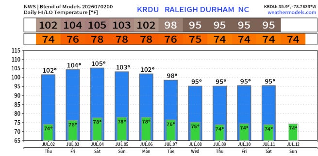
The Carolinas will be the last spot to see relief, with temperatures likely to reach or exceed 100F in many locations into the first part of next week.

The potential for thunderstorms and associated cloud debris remain one of the question marks regarding the temperature forecast, particularly this weekend as the upper level high pressure ridge helping to suppress storms continues to weaken. This will also open the door for the risk of severe weather to expand into the Mid-Atlantic, with severe storms capable of damaging winds an increasing threat.
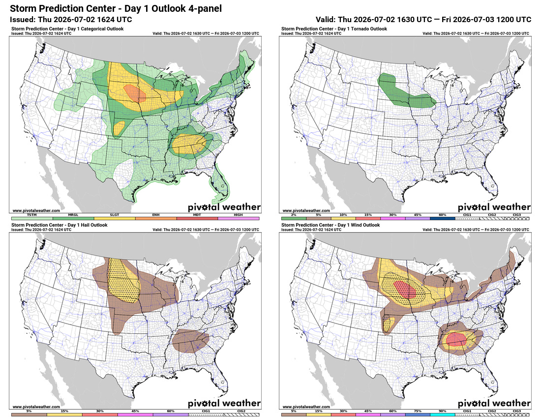
For today, the primary risk of severe storms should be over the Northern Plains and Upper Midwest. Clusters of severe storms with damaging wet microburst wind gusts are also expected in the Tennessee Valley region.
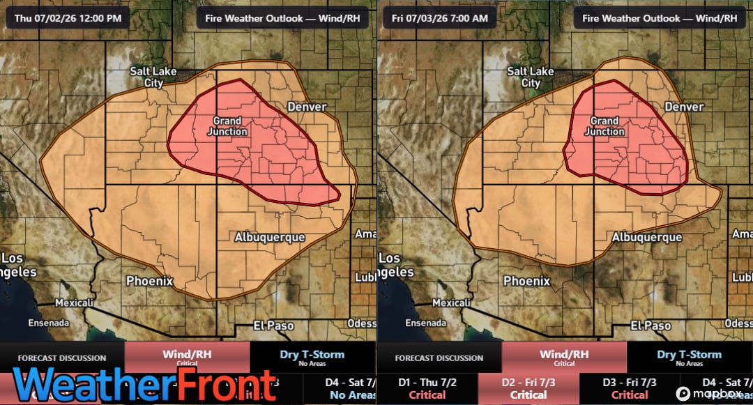
Critical fire weather conditions will continue in the Four Corners region today and again Friday afternoon and evening as dozens of wildfires continue to burn in the region, forcing evacuations, destroying buildings and homes and causing fireworks restrictions for the Independence Day weekend.
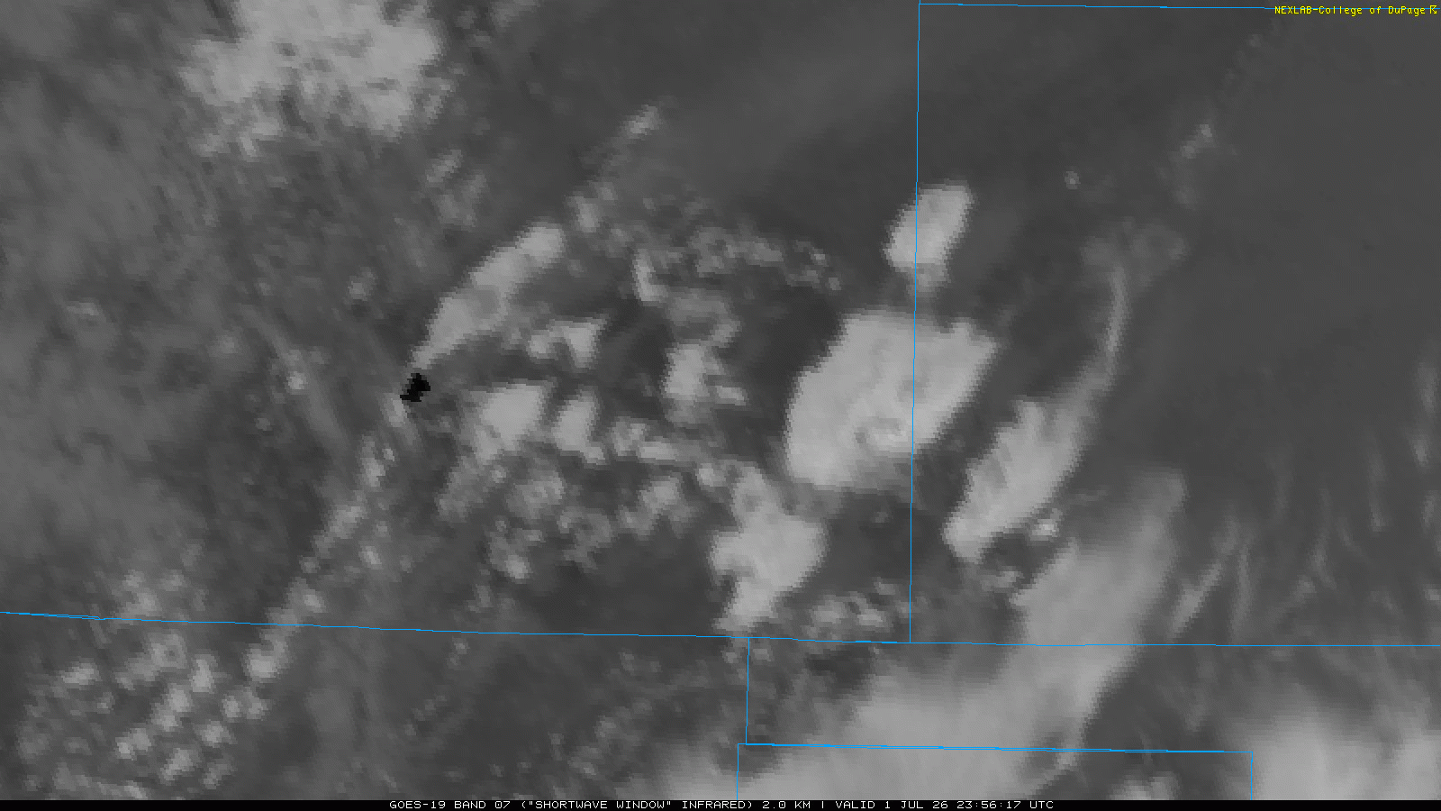
The Aspen Acres fire west of Pueblo was particularly active on Wednesday afternoon, with shortwave infrared satellite imagery showing a large intense hotspot, and periodic buildups of pyrocumulus and even pyrocumulonimbus. The fire nearly doubled in size on Wednesday to just shy of 50,000 acres, and has destroyed at least 180 buildings.
A trend toward lighter winds early next week across the region will also unfortunately be accompanied by a trend toward increasing heat, with widespread well above normal temperatures expected across the West as we move closer to mid-July. While there should also be a gradual building of monsoon thunderstorm activity across the Southwest that could start to bring some rainfall, it will also be accompanied by increased lightning activity. Given the already serious wildfire activity and ongoing drought, we will be watching forecast trends closely the next few weeks.
Programming Reminder: Given the ongoing active weather, I am utilizing the Substack Chat feature to share periodic real-time updates. I also do occasional live videos to provide briefings and updates about the evolution of severe weather and flash flooding risks. As a reminder, these are benefits that paid subscribers receive for their support of Balanced Weather. Any videos I do will also be recorded and shared to all subscribers. I also provide updates on my BlueSky and Facebook feeds, and via occasional Substack Notes.

Leave a comment