
Positive news on NWS hiring front to replace staff lost in OMB/DOGE cuts
Jul 06, 2026
Obviously there continues to be a lot of active weather nationally and globally, but I want to start off this week talking about some National Weather Service news and issues. CBS News published an article today evaluating the state of the NWS as we enter hurricane season and a year after significant job losses due to OMB and DOGE federal reductions. As in most reporting on the NWS staffing and budget issues these days, they highlight (again) the issues with upper air balloon soundings — and I wanted to expound a little bit on my quotes in the article on the subject.
While I continue to emphasize that we really do not know what impact the reduction in upper air balloons and changes in the cadence of releases (many sites switching from a morning balloon release to a midday release) has tangibly had to model forecasts, what has become clear to me in conversations with colleagues and numerous references to the issue in articles and forecast discussions is that meteorologists’ confidence in the models and their own ability to analyze some situations has been damaged by the lack of upper air data. Again, there really is not any way to quantify how much of an impact that is having on forecast and warning services, but it is likely having some. Hazardous weather warnings and outlooks are still ultimately made by a human being, so if that human has less confidence in the data they are relying upon, it will have consequences. As I have mentioned in earlier posts, my discussions with atmospheric scientists with much more expertise than I have in numerical weather models suggests that the serious reduction of upper air data from Alaska discussed in the article by my retired NWS colleague Rick Thoman is probably having the biggest actual impact on global model forecasts.
The article provides an update on significant progress the NWS has made in hiring in recent months, which is obviously good news and getting more entry level meteorologists in the pipeline should help with the upper air balloon release cadence issues in the Lower 48. One area that I remain particularly concerned about for the NWS is the stability and robustness of the WSR-88D (NEXRAD) Doppler weather radar network, and the number of electronics technicians with actual experience in maintaining these aging radars. The “88” in WSR-88D stands for 1988, the year the prototype for this radar was deployed — operational deployment occurred through the 1990s. While the radar has of course had periodic updates to both its software and hardware over the decades, it has become an increasingly challenging system to maintain and recent analyses have shown that the radar network will have increasing degradation in the coming years.
Very observant readers may have noticed that the radar loop I posted in yesterday’s newsletter showing the severe storms impacting central Oklahoma was not from the operational NWS radar for central Oklahoma (KTLX), but rather from the NWS Radar Operations Center (ROC) radar KCRI. I used this radar because the operational KTLX radar located just northeast of Norman was inoperable much of the holiday weekend due to issues with the radar’s cooling system, and per the local office remains vulnerable to further outages due to this situation.
Central Oklahoma is lucky to have research and testbed radars as well as an operational FAA Terminal Doppler Weather Radar (TDWR) that can help provide radar coverage if the operational NEXRAD is offline. Unfortunately, many parts of the country are not so fortunate, and if their radar is down, there is a serious loss of data.
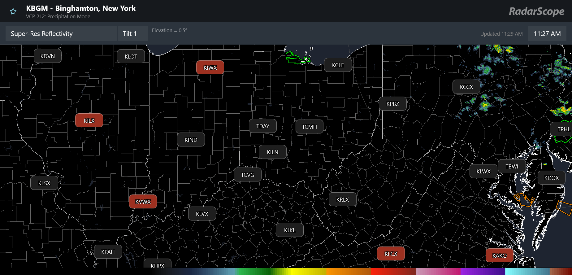
This current RadarScope map shows that five operational NWS radars are currently not providing data (the red shaded site identifiers) across the central and eastern United States where thunderstorms have been an issue in the last few days.
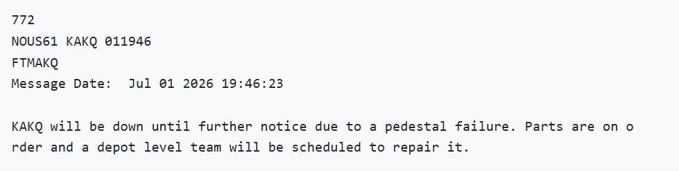
The NWS Wakefield, VA radar (KAKQ) has been down since July 1st and per this NWS message will be down “until further notice due to a pedestal failure.” A pedestal failure is a catastrophic issue for a radar as the pedestal is the large piece of equipment supports and rotates the radar dish. Repair will take a significant period of time as the necessary parts and equipment (including a crane) must be obtained and lined up.
The Northern Indiana radar (KIWX) has been down since July 3rd, and the latest message from the NWS office indicates that parts needed to repair the radar are on order and the hope is for the radar to be operable again on Tuesday. The Evansville, IN (KVWX) radar is offline due to cooling issues that sound similar to the one experienced by the KTLX radar this weekend. The southwest Virginia radar (KFCX) has been down the last few hours for unknown reasons. The only one of these five radars that appears to be down for routine maintenance and should quickly return to service is the Central Illinois radar (KILX).
These sorts of issues with radars suffering significant and prolonged outages due to equipment failure are only expected to become more common as the network continues to age — and are complicated by the loss of experienced electronics technicians in the last year due to the OMB and DOGE cuts. Of course, missing radar data is a significant problem for NWS offices and meteorologists when dealing with hazardous weather operations — but the Doppler weather radar network is truly a critical piece of national infrastructure. We as a society rely on it for so many applications, from keeping the national airspace safe to water resource management to simply being able to look at a weather app and see if it is going to rain while we are out jogging. I think we take it for granted — and I fear that as the network continues to degrade in the coming years, we may learn the hard way just how important it is.
NOAA is currently working on developing the Radar Next program that will determine the structure and technology of the nation’s next weather radar network — but developing and implementing that new network will obviously take many years. Private sector companies such as Climavision have been partnering with government and academic entities to deploy smaller, less expensive Doppler radars to help fill gaps in the NEXRAD network (a whole other topic which I plan to cover soon) — and these private radar networks will likely become a part of the future national weather radar network.
I think it will be crucial for NOAA and the broader weather community to closely monitor the trends in NEXRAD availability in the coming months and work to develop contingency strategies on how to fill any prolonged critical gaps that may arise in the network due to radar failures. For example, NOAA could look at procuring mobile radars that could be deployed to help fill gaps along the coast during a hurricane landfall or in an area threatened by a tornado outbreak, or partner with private companies or academic institutions that could provide such services. These strategies could then be utilized even once a new, robust network is deployed to help enhance radar coverage and services when high impact weather events occur.
For many meteorological and societal applications, weather radar data is truly critical information that cannot be provided by other means. Our government agencies and the meteorological community needs to work together to ensure that we have the radar data needed to continue to support everything that relies upon it.
I will have posts and/or videos about the various ongoing weather events later today.


Leave a Reply